Wabasha County lies in southeastern Minnesota, where the Mississippi River forms a long eastern edge and deeply cut valleys break up the interior uplands. Lake City sits near the northern river corridor, Wabasha and Kellogg occupy the eastern side, Mazeppa and Zumbro Falls anchor the west, and Plainview and Elgin lie in the southern extension of the county. Because the landscape changes quickly from low river bottoms to high ridges, the road, water, and elevation views add different pieces of the same picture. High-resolution JPG versions of the maps shown on this page are available in the ZIP download box below.
A useful way to orient yourself is to start with the Mississippi River and U.S. 61. That highway follows the river corridor through Lake City, Wabasha, and Kellogg, while U.S. 63 turns inland from Lake City toward Zumbro Falls. Minnesota Highway 60 connects the western side of the county with Wabasha, and Minnesota Highway 42 provides an important connection between the Plainview area and Kellogg. These routes do not cross a uniform plain; they pass through a county where narrow valleys, tributary ravines, and steep bluff country create strong local differences in terrain.
Table of Contents
The Mississippi River corridor from Lake City to Wabasha and Kellogg
The county map is dominated by the Mississippi River along the eastern boundary. Wabasha is positioned near the middle of that river edge, Lake City is farther north, and Kellogg is south of Wabasha. Minneiska appears near the southeastern edge beyond Kellogg. U.S. 61 ties these river communities together, so it is the clearest road reference for understanding the eastern side of Wabasha County. The map also shows how close the highway remains to the broad river valley for much of this route.
Lake City also marks the northern end of a major inland connection. U.S. 63 leaves the river corridor and runs southwest toward Zumbro Falls, where it meets the east-west route marked by Minnesota Highway 60. From Wabasha, Highway 60 reaches west toward the same interior area. South of Wabasha, Kellogg connects to Minnesota Highway 42, which turns southwest toward Plainview. These roads help explain why the county is not organized around a single central town; its travel pattern is divided among the river edge, western valleys, and southern uplands.
Farther west, Mazeppa lies close to the county line, with Zumbro Falls to its east. Millville and Hammond occupy smaller positions in the southwest, while Plainview and Elgin sit in the southern projection of the county. Bellechester appears near the northwestern boundary. The outline of Wabasha County is therefore irregular rather than rectangular, with a long river side, a western step, and a southern extension that contains a separate cluster of communities.
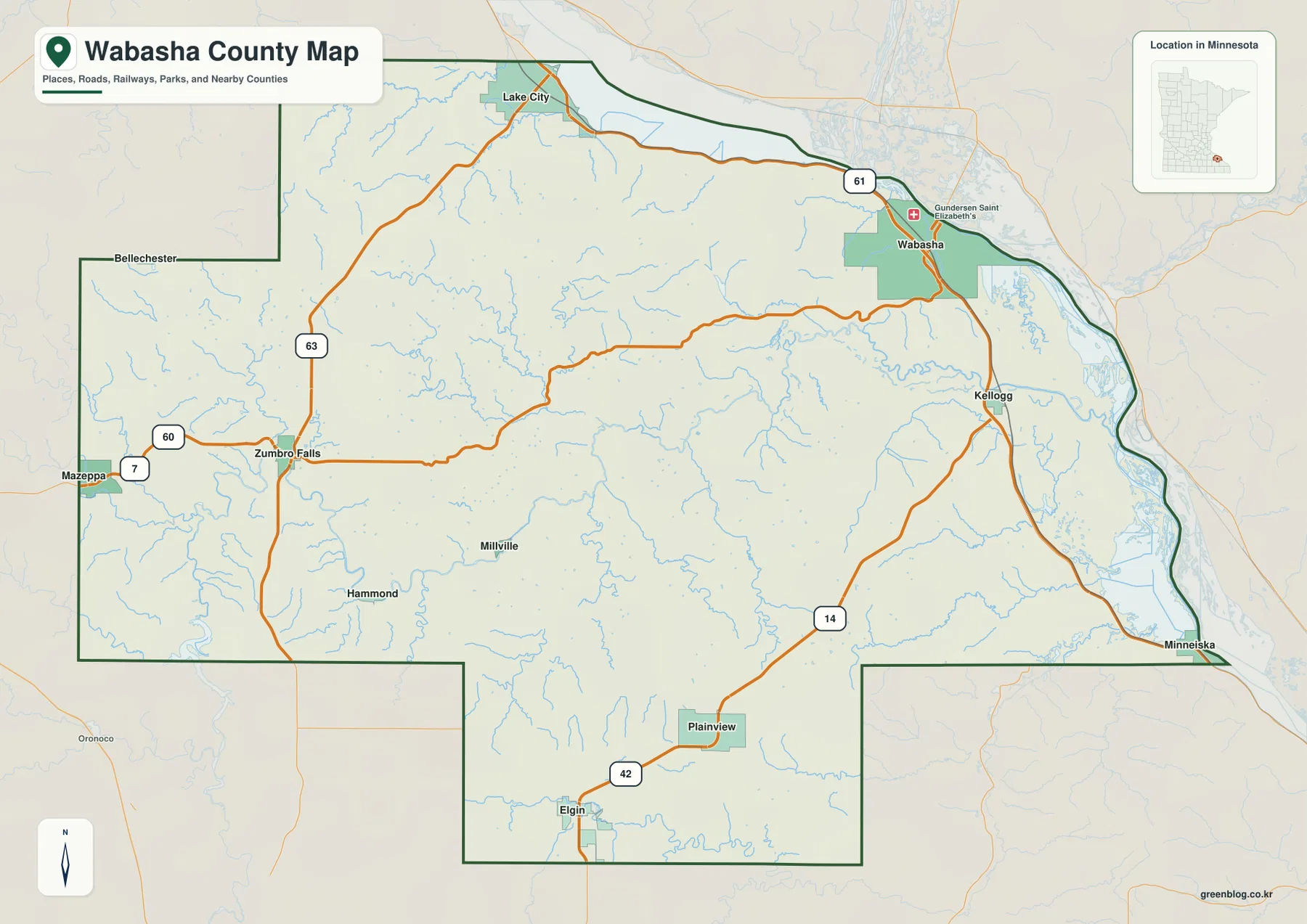
This map is designed for county-scale orientation, not parcel surveying or legal boundary determination. Along the Mississippi River especially, islands, channels, and broad water areas make the landscape more complicated than a single boundary line suggests. The map is useful for regional context, travel planning, and educational reference, but property or jurisdictional decisions should be checked against current official county or state records.
Six cities reveal the split between river towns and inland communities
The city map highlights Lake City, Plainview, Wabasha, Elgin, Mazeppa, and Kellogg. Its reference ranking places Lake City first, followed by Plainview and Wabasha, with Elgin, Mazeppa, and Kellogg completing the set. Those figures are best treated as map reference values rather than substitutes for a current official census estimate. Their main value here is visual: the six places are spread across very different parts of the county instead of forming one compact urban cluster.
Lake City and Wabasha are both associated with the Mississippi side of the county, but they are separated by a substantial stretch of river corridor and surrounding bluff terrain. Plainview and Elgin are inland in the south, far from the low river margin. Mazeppa sits near the western edge and relates more closely to the Zumbro Falls side of the county, while Kellogg occupies a river-side position where the route toward Plainview meets U.S. 61. This distribution makes the city map especially helpful for understanding why different roads matter in different parts of Wabasha County.
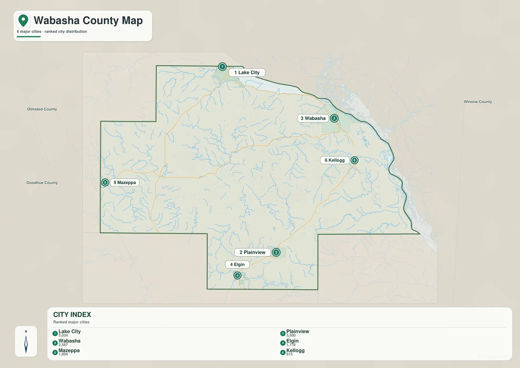
The simplified city view is useful when the full road network feels crowded. It quickly shows which towns belong to the river edge and which are inland. A trip between Lake City and Wabasha follows a very different geographic setting from one between Mazeppa and Plainview, even when both journeys remain within the same county. Returning to the general map after learning these positions makes the numbered highways and smaller communities much easier to place.
Zumbro and Whitewater valleys cut across the interior uplands
The terrain-and-water map changes the emphasis from roads to drainage and relief. The Mississippi River forms the broad eastern water corridor, while the Zumbro River enters the southwestern part of the county near Zumbro Lake and winds through a lower valley. In the southeast, the Whitewater River approaches the Mississippi, and the North Fork Whitewater River crosses the southern extension. These larger streams are joined by many short tributaries, producing a dense network of valleys across the interior.
Several smaller named waters help show how broken the landscape is. Trout Brook and Spring Creek appear in the western half, Long Creek crosses the central area, and E Indian Creek is labeled farther east. Truesdale Lake and Robinson Lake sit near the northeastern Mississippi corridor, while McCarthy Lake appears farther south. None of these features dominates the county alone, but together they explain the many narrow green valleys and steep-sided ravines visible on the relief background.
North of Wabasha, the Mississippi widens toward the Lake Pepin area, giving the northern river corridor a different character from the narrower reaches farther south. On the western side, Zumbro Falls and Mazeppa are more closely associated with the Zumbro River system. Plainview and Elgin sit above a web of smaller tributaries, and the Whitewater drainage becomes increasingly important toward the southeast. The county therefore contains several distinct water settings rather than one river system repeated from end to end.
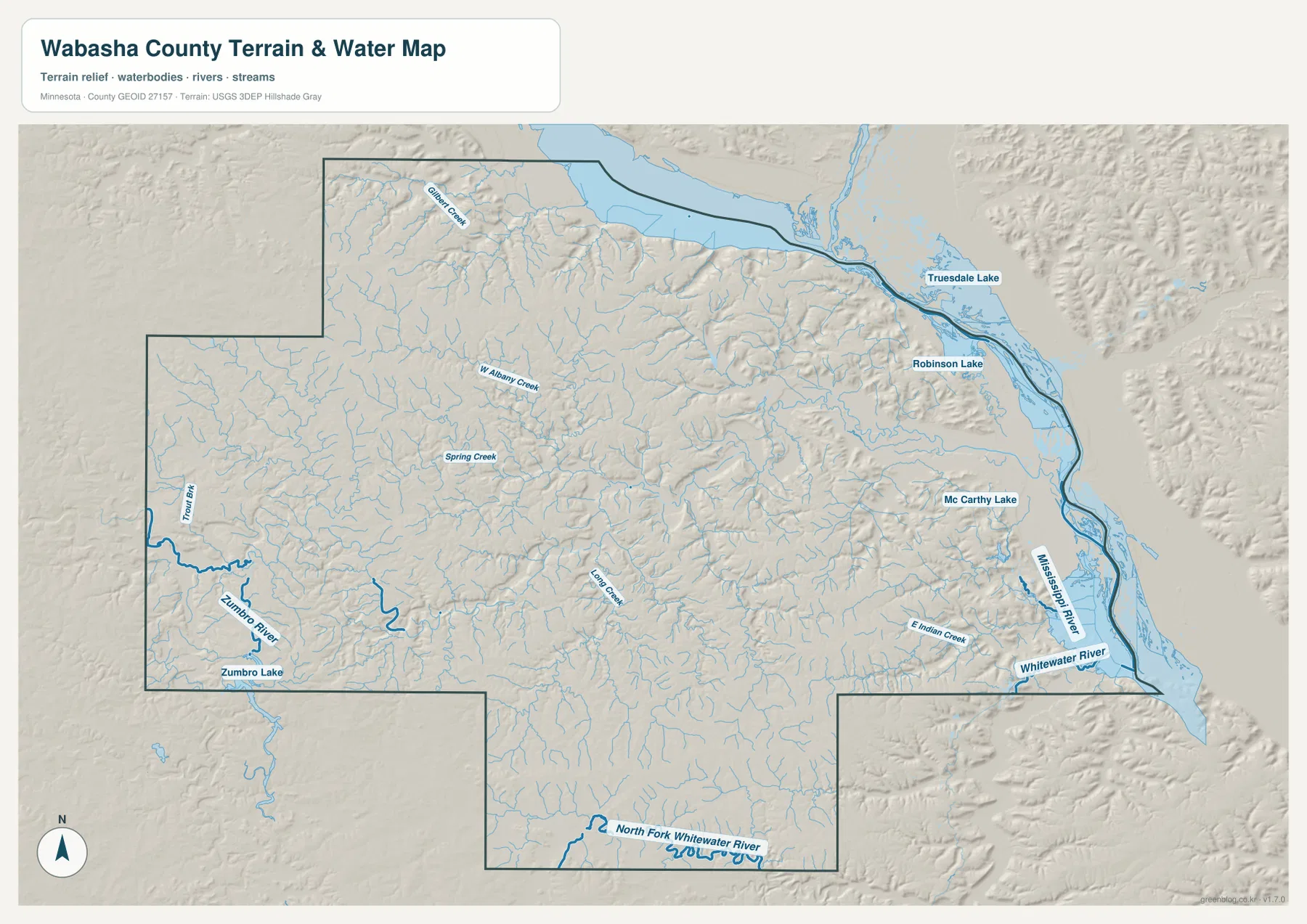
This is a geographic reference map, not a flood-risk, navigation, water-depth, or water-quality product. Conditions on rivers and smaller streams can change, and professional or safety-sensitive decisions require current agency data. For county orientation, however, the map is useful because it shows which communities sit near major rivers, where tributary valleys cut into the uplands, and why the eastern bluff country looks so different from the broader western interior.
A 201–379 meter range separates river bottoms from high ridges
The elevation legend gives an actual county range of roughly 201 to 379 meters, with a mean near 304 meters. The lowest greens form a long strip along the Mississippi River, including the lower ground near Wabasha and Kellogg. Immediately west of that low corridor, brown and orange ridges rise sharply. The contrast is much stronger than it is in many flatter Minnesota counties, and the shaded relief makes the branching ravines especially easy to see.
The same pattern appears near Lake City, where low river-side ground sits close to higher inland ridges. Across the central and eastern county, tributaries have cut narrow valleys into the uplands, producing repeated fingers of lower green terrain between higher brown slopes. The western side around Mazeppa and Zumbro Falls is generally broader in appearance, but the Zumbro River and its tributaries still create noticeable lower corridors through the surrounding land.
Plainview and Elgin occupy the southern inland section, where higher colors cover much of the map but stream valleys continue to break up the surface. Following the position of Minnesota Highway 42 from Plainview toward Kellogg illustrates the larger change well: the route connects higher inland country with the much lower Mississippi corridor. The elevation map is therefore useful not only for finding high and low points but also for understanding why roads and towns occupy particular valleys or ridge approaches.
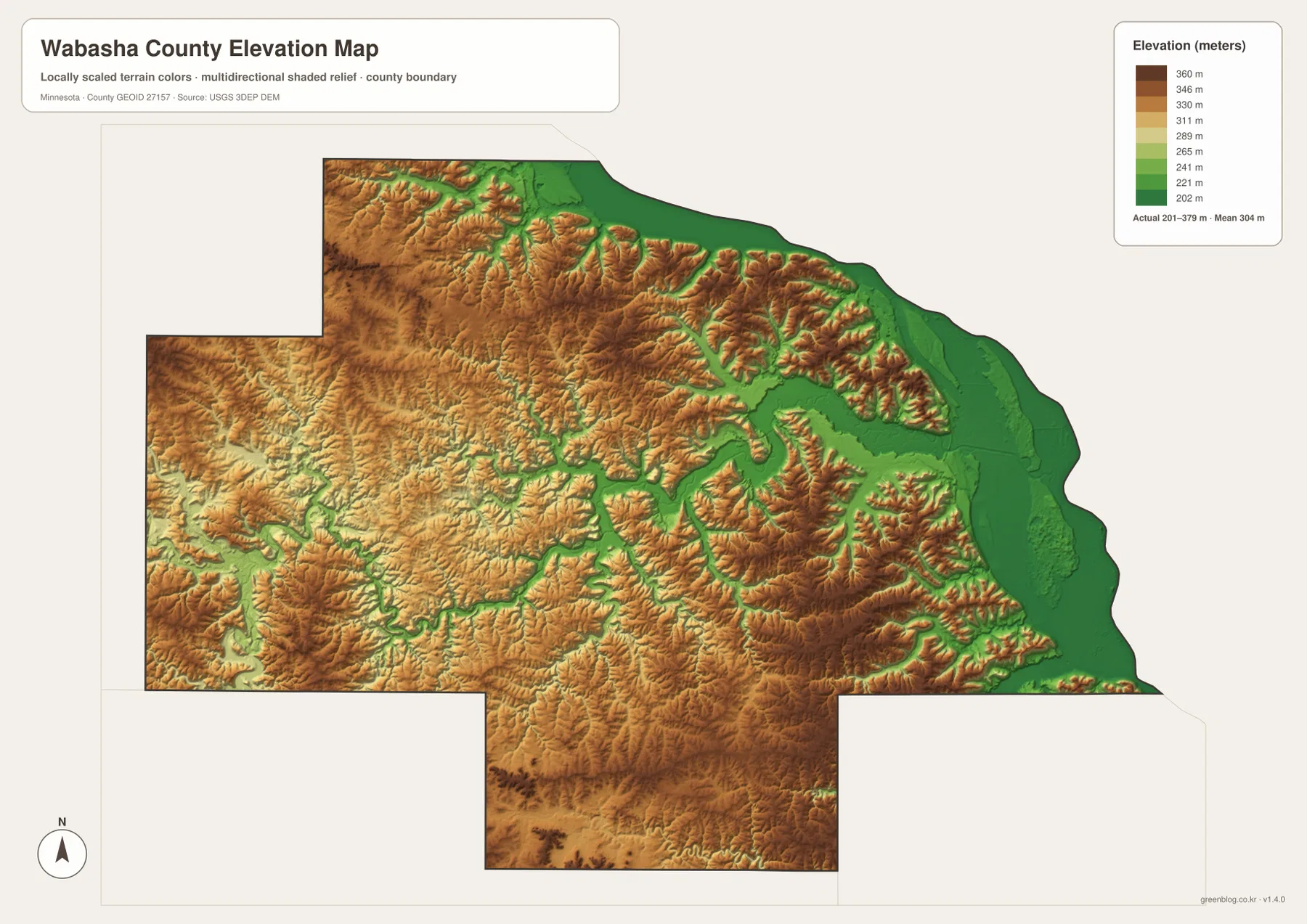
The elevation image is generalized for county-scale comparison. It should not be used to determine the precise elevation of a house, road segment, construction site, or drainage feature. Engineering, surveying, and site design require higher-resolution source data and field verification. Here the map works best as a visual explanation of the broad difference between the Mississippi lowlands, the Zumbro and Whitewater valleys, and the higher ridges between them.
Reading roads and terrain together
U.S. 61 can look like a simple north-south river highway on the county map, but the elevation view reveals how tightly that corridor is squeezed between low Mississippi ground and steep interior hills in many places. Minnesota Highway 60 leaves Wabasha and climbs away from the river toward Zumbro Falls through a much more broken inland landscape. The water map reinforces the same idea by showing numerous tributary valleys between the major towns.
From Lake City, U.S. 63 provides another clear example. It departs the river side and heads southwest toward Zumbro Falls, moving from low terrain into higher country. Once Zumbro Falls becomes the reference point, the Zumbro River is more useful for understanding the landscape than the Mississippi. Farther south, Plainview and Elgin belong to the upland part of the county, while Kellogg sits at the transition back toward the eastern lowland.
For a first look at Wabasha County, start by locating U.S. 61, the Mississippi River, U.S. 63, Zumbro Falls, and Plainview on the general map. Then compare the Zumbro and Whitewater systems on the water map before checking the green river bottoms and brown ridges on the elevation view. Moving through the maps in that order turns a complicated outline into a set of recognizable regions: river corridor, western valley country, and southern upland communities.
Download files and appropriate uses
The WebP images on this page are optimized for quick viewing. The ZIP package contains high-resolution JPG originals of the same county, city, water, and elevation maps, each at 3638×2572 pixels. The larger files are better for zooming into labels, printing classroom material, preparing presentations, or keeping an offline county reference. They are not substitutes for live navigation, legal parcel records, flood studies, engineering plans, or survey-grade elevation products.
Frequently Asked Questions
Which road is most useful for connecting Wabasha and Lake City?
U.S. 61 is the main map reference because it follows the Mississippi River corridor through both places. U.S. 63 turns inland from Lake City toward Zumbro Falls, while Minnesota Highway 60 heads west from Wabasha. Driving times and road conditions can change, so current transportation information should be checked separately when planning an actual trip.
Which rivers stand out on the Wabasha County maps?
The Mississippi River is the largest feature and forms the long eastern edge of the county. Inland, the Zumbro River is prominent in the southwest, while the Whitewater River and North Fork Whitewater River are important in the southeast and southern extension. Numerous smaller creeks cut the uplands between these larger river systems.
What does the elevation map show most clearly?
The legend shows an actual range of about 201 to 379 meters and a mean near 304 meters. Low green terrain follows the Mississippi River, while much higher ridges rise immediately inland and are dissected by narrow tributary valleys. The map is intended for regional comparison, not precise site elevation or surveying.
Map File Information
The ZIP contains high-resolution JPG originals of the Wabasha County general map, city map, water map, and elevation map shown on this page.
- Included Files: 4 high-resolution JPG maps
Related Maps
Sources and references
- Wabasha County official website — county government and local information
- Minnesota Department of Transportation Wabasha County Maps — road and county mapping references
- USGS National Hydrography — rivers, streams, and water features
- USGS 3D Elevation Program — elevation and terrain reference data
- Wabasha County Historical Society — county history and Mississippi River Valley context
Green Map creates custom-edited map images using open geographic data sources such as geoBoundaries, Natural Earth, OpenStreetMap, and government open data. These maps are edited visual materials, not raw data files, and are provided for education, documents, presentations, and graphic reference.