Scott County sits southwest of Minneapolis–Saint Paul and combines a busy northern suburban area with smaller river and farm communities farther south and west. Shakopee, Savage, and Prior Lake are clustered in the north, while Jordan, Belle Plaine, and New Prague are more widely separated. The Minnesota River curves around much of the western and northern county edge, U.S. 169 links several of the best-known communities, and the eastern interior rises well above the river valley. The maps on this page separate those features into general, city, water, and elevation views, and the original high-resolution JPG files can be downloaded for printing or enlargement. High-resolution map files are available for download in the section below.
A useful way to orient yourself is to start with Shakopee and the Minnesota River. Shakopee lies just south of the river, Savage is immediately to the east, and Prior Lake is farther south. Jordan and Belle Plaine sit closer to the river corridor in the west, while Credit River and Elko New Market occupy higher ground toward the east and southeast. Lakes such as Prior, Spring, and Cedar are interspersed with creeks and rolling terrain, so Scott County changes quickly from a dense urban edge to open countryside, lake districts, and river lowlands.
Table of Contents
Use Shakopee and the Minnesota River to get oriented
The Minnesota River is the clearest natural reference on the county map. It follows much of the western boundary, bends around the northwest side, and then continues along the north near Shakopee. That winding river edge is easy to distinguish from straighter county lines and helps explain Scott County’s position relative to Carver, Hennepin, and Sibley counties. Shakopee, Jordan, and Belle Plaine are all close enough to the river to make it a useful landmark when moving from one part of the county to another.
U.S. 169 is the most obvious north-south route on the general map. It passes through Shakopee and continues southwest toward Jordan and Belle Plaine, tying together communities that otherwise sit in very different landscapes. Minnesota 41 crosses the river into the Shakopee area, Minnesota 282 connects Jordan and the Prior Lake side of the county, and Minnesota 13 runs south from Prior Lake. Minnesota 21 serves Jordan and continues toward New Prague, while Interstate 35 clips the eastern side near Elko New Market. Together these roads provide several clear anchors without turning the map into a turn-by-turn navigation product.
The road pattern also shows why travel within Scott County can feel different depending on where you start. A trip from Shakopee toward Jordan follows the U.S. 169 corridor, while destinations near Prior Lake, New Prague, or Elko New Market may depend on different state highways. The northern area has more closely spaced roads and urban development; the southwest has longer gaps between towns. For actual driving, current construction, closures, traffic, and local street access should be checked with live transportation information.
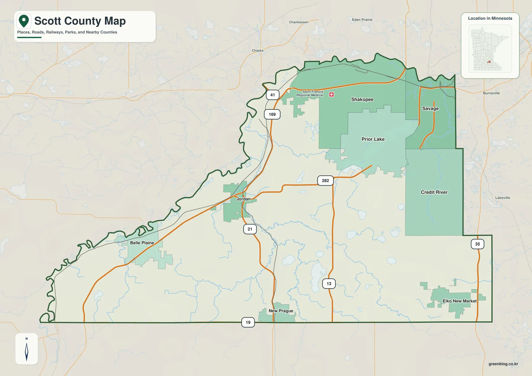
The distribution of towns becomes clear even before switching to the city-only view. Shakopee and Savage form a close pair in the north, with Prior Lake nearby to the south. Jordan lies farther west, Belle Plaine is in the southwest, and New Prague is on the southern edge of the county. Elko New Market and Credit River help define the eastern side. This arrangement matters because the label “Scott County” can refer to places that are relatively close to the Twin Cities or to much quieter areas many miles from the northern cluster.
Northern cities are close together; southern communities are farther apart
The city map removes most background detail and emphasizes the principal communities. Shakopee, Savage, and Prior Lake are grouped tightly in the north and northeast, while Jordan, Belle Plaine, and New Prague are spread across the western and southern parts of the county. The ranking printed on the supplied city map reflects the data used when that map was created and should not automatically be treated as the newest population estimate. Its strongest value here is spatial: it makes the concentration of the three northern cities immediately visible.
Shakopee is the easiest urban anchor because it is both the county seat and a major road center near the Minnesota River. Savage lies to the east near the Dakota County side, and Prior Lake is south of both. The spacing among these cities is much tighter than the spacing farther down the county. South of the northern cluster, open land becomes more prominent before Jordan, Belle Plaine, New Prague, and other smaller communities appear.
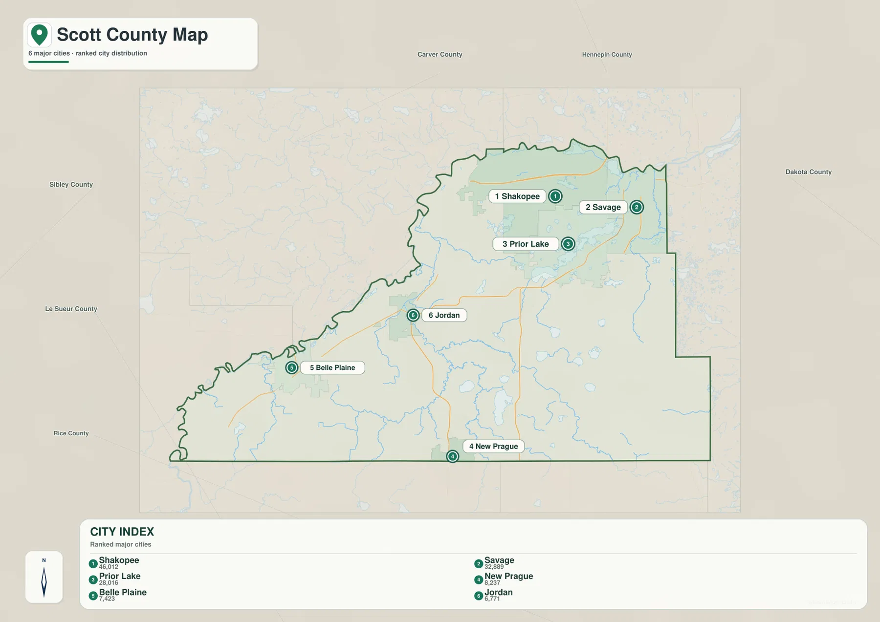
Jordan is a particularly useful midpoint for understanding the county. It is near U.S. 169 and Minnesota 21 and close to Sand Creek and the Minnesota River lowlands. Belle Plaine is farther southwest near another large bend of the river, while New Prague straddles the southern county edge and connects Scott County with neighboring areas. Elko New Market is not part of the six-city ranking displayed on this map, but it remains an important southeastern reference on the general county map because it lies near Interstate 35.
For classroom work, presentations, or simple orientation, the city map is often the quickest way to explain where the major communities sit. When the question involves how those places connect, however, the general map is a better companion. It adds U.S. 169, state highways, the county boundary, and the Minnesota River, making it easier to explain why Shakopee, Prior Lake, Jordan, and Belle Plaine occupy distinct parts of the same county.
The Minnesota River frames the county, while lakes fill the interior
The water map is dominated by the Minnesota River along the west and north, but Scott County has a much richer interior network than that single river suggests. Sand Creek runs through the Jordan area toward the larger river, while Picha Creek and Porter Creek occupy lower routes through the central and northern interior. Raven Creek and Fabor Creek appear in the southwest. These streams are smaller than the Minnesota River, yet they help explain the numerous shallow valleys visible on the terrain and elevation views.
The central and eastern parts of the county contain a noticeable group of lakes. Prior Lake and Spring Lake are closest to the northern population center, while Cedar Lake and Pleasant Lake lie farther south. O’Dowd Lake and Cynthia Lake add smaller water bodies within the same broad lake district. The Credit River runs through the eastern side, and the Vermillion River appears near the southeastern boundary, showing that not every local stream follows a direct route to the Minnesota River.
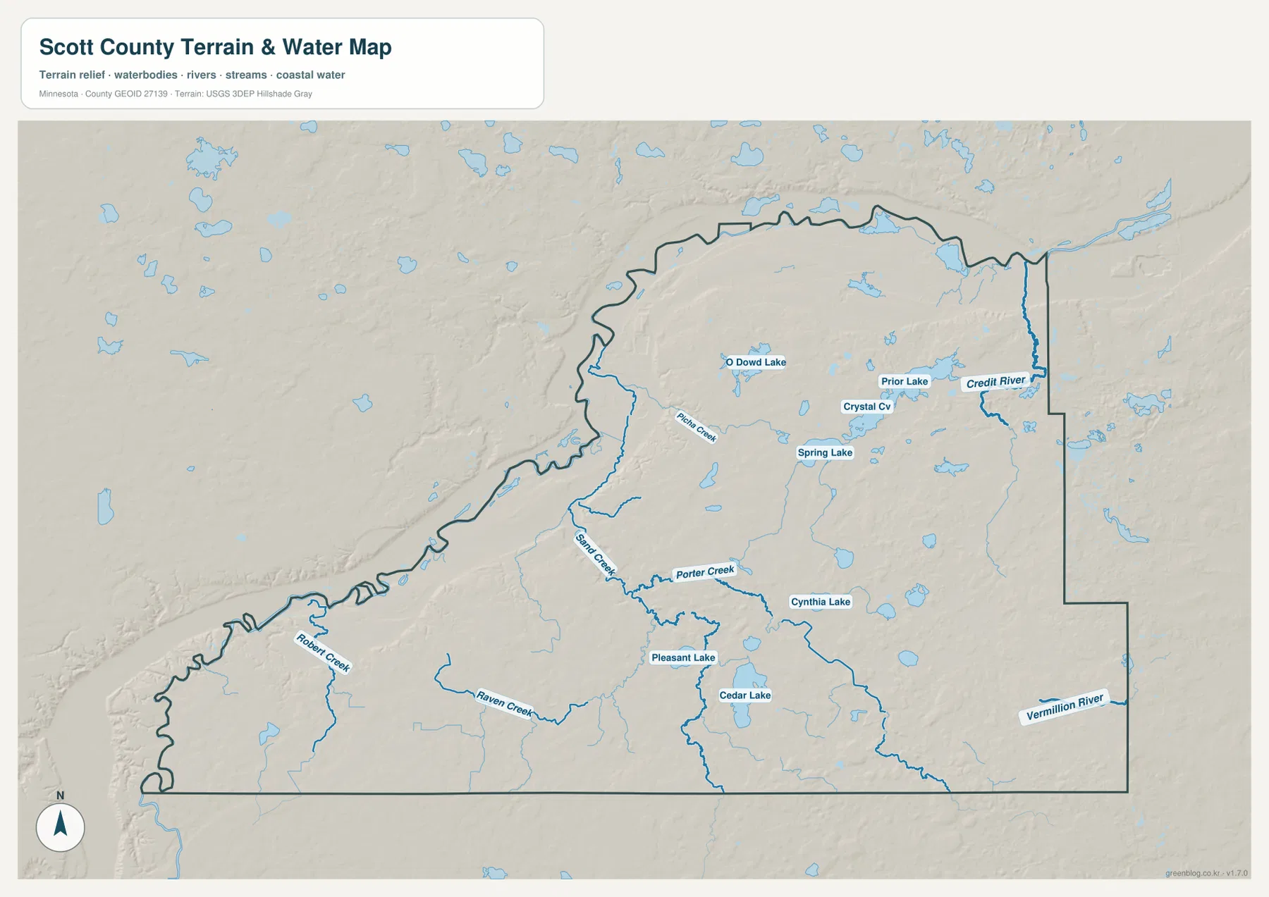
Several of these lakes are tied to public recreation areas. Scott County’s official parks information describes Cedar Lake Farm Regional Park on the south shore of Cedar Lake and Spring Lake Regional Park near Spring Lake and Prior Lake. That connection gives the map practical context: the blue lake shapes are not simply cartographic decoration but recognizable destinations used for parks and outdoor recreation. Shoreline access can still vary by location, so the map should not be read as a guide to public versus private property.
This water map is meant for geographic orientation, not for flood insurance, water quality, fishing regulations, boating rules, or legal access. A stream or lake shown on the page may have seasonal or regulatory conditions that are not represented here. Likewise, low land next to the Minnesota River does not by itself establish flood risk for a specific parcel. Use dedicated official sources when those details matter.
A 213–372 m elevation range separates river bottoms from eastern hills
The elevation map shows an actual range of about 213 to 372 meters, with a mean near 284 meters. The lowest greens follow the Minnesota River along the northern and western edge and extend into the valleys near Shakopee, Jordan, and Belle Plaine. Moving inland, the colors shift through yellow toward brown, with much higher ground appearing across the eastern and southeastern parts of the county. Credit River and Elko New Market are useful place names for finding that higher side of the map.
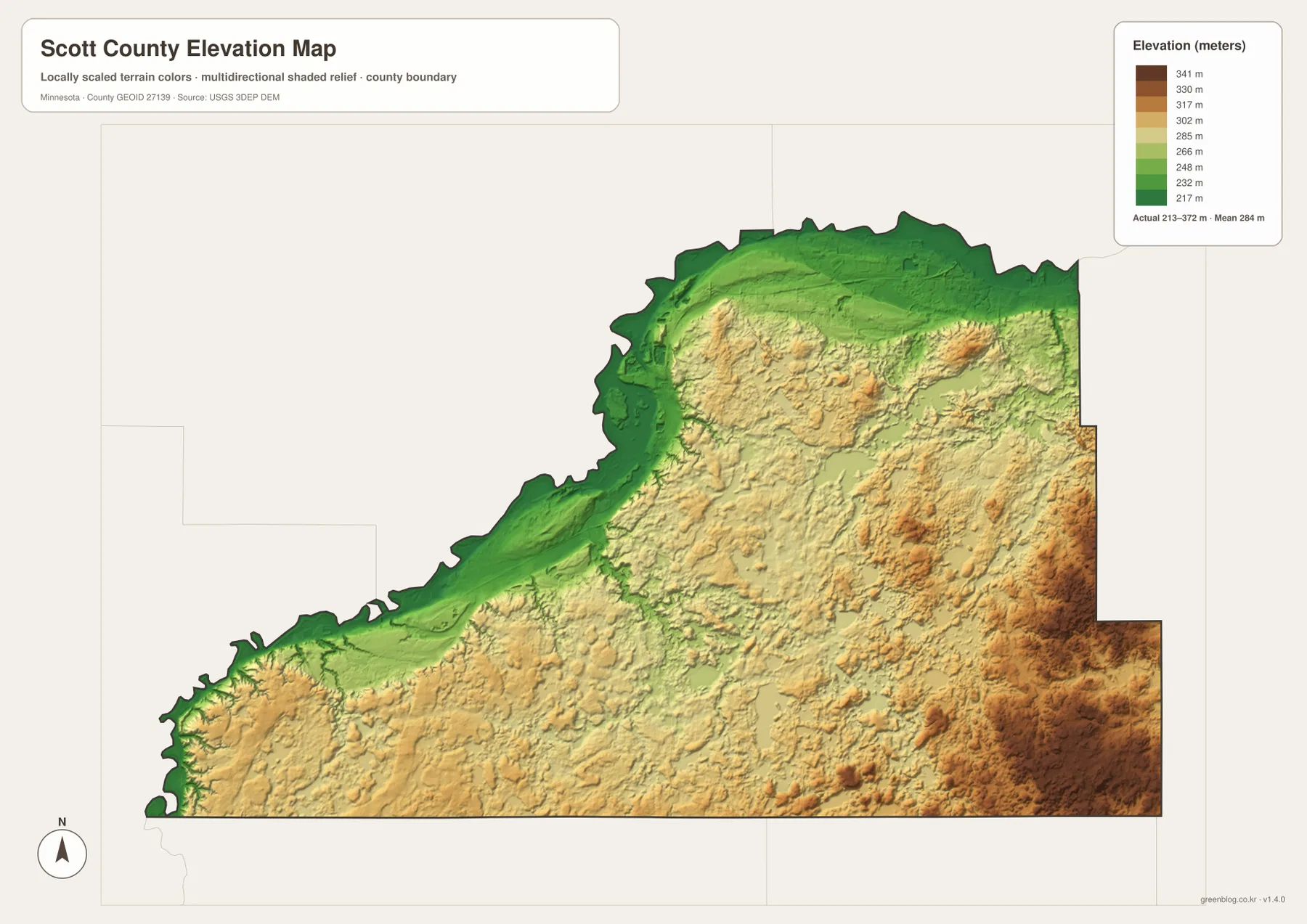
Comparing the elevation and water maps helps explain many of the narrow low corridors inside the county. Sand Creek, Picha Creek, and other streams follow lower ground on their way toward larger valleys. The lakes also sit among rolling terrain rather than on a perfectly level surface. Scott County’s parks information describes the Murphy-Hanrehan Park Reserve area near the northeast as hilly glacial terrain, which matches the more broken relief visible in that part of the elevation map.
Shakopee and Prior Lake are close on a city map, but the elevation view shows that their physical settings are not identical. Shakopee is immediately south of a broad river lowland. Higher terrain appears quickly to the south, and the Prior Lake area lies farther into that rolling interior. Jordan and Belle Plaine also sit close to low river country, whereas the southeastern side around Elko New Market rises more consistently. Those differences are large enough to be visible even at county scale.
The colored elevation surface is a countywide reference rather than a survey product. It can show which parts of Scott County are broadly higher or lower and help explain how river valleys relate to nearby uplands. It should not be used to determine a building-site elevation, design drainage, establish a parcel boundary, or replace engineering measurements. For precise work, use USGS 3D Elevation Program data or an appropriate professional survey source.
Choose the map that matches the question
The general county map is the best first choice when you need several kinds of information at once. It places Shakopee, Prior Lake, Jordan, Belle Plaine, New Prague, and Elko New Market within the county boundary and shows the major roads that connect them. It is also the only view that makes it easy to discuss roads and the Minnesota River at the same time. If the goal is simply to compare the main communities without smaller labels, the city map is cleaner and faster to read.
Use the water map when the question centers on the Minnesota River, Sand Creek, Credit River, or the cluster of lakes around Prior Lake and Spring Lake. Add the elevation map when you want to explain why the river edge is low or why the southeast appears hillier. Looking at the two together makes the connection between streams and low valleys easy to see without requiring specialized GIS software or technical background.
The WebP images embedded on the page are optimized for quick online viewing. For printing, large slides, worksheets, or any use where small road labels need to stay clear, the original JPG files are preferable. The download archive contains four high-resolution images—the general county, city, water, and elevation maps—and each is 3638 by 2572 pixels. They are useful for educational materials, regional orientation, presentations, and personal reference, but they are not substitutes for legal parcel maps, engineering plans, or live navigation.
Frequently Asked Questions
What is the quickest way to locate Shakopee and Prior Lake?
Find the Minnesota River along the northern county edge and look just south of it for Shakopee and U.S. 169. Prior Lake is south of the Shakopee–Savage area and is easy to recognize by both the city name and the nearby lake. Use the city map for the simplest comparison, or the general map when roads and the river also matter.
Which rivers and lakes stand out most on the Scott County maps?
The Minnesota River is the largest reference because it curves around the western and northern sides of the county. Sand Creek, Picha Creek, Porter Creek, and the Credit River add important interior waterways. Prior Lake, Spring Lake, Cedar Lake, and Pleasant Lake are among the most visible lakes. The water map is designed for location and comparison, not for flood risk, water quality, fishing rules, or property access.
Why is the Minnesota River edge so much lower on the elevation map?
The Minnesota River occupies one of Scott County’s broadest low corridors, so its valley is shown in green along much of the northern and western boundary. Elevation rises inland, and higher yellow and brown terrain becomes widespread toward the east and southeast. With an actual county range of about 213 to 372 meters, the difference is large enough to stand out clearly at this scale.
Map File Information
The ZIP includes the original JPG versions of the Scott County general, city, water, and elevation maps shown on this page.
- Included Files: Use only the versions confirmed in the article and supplied images
- File Type: Use the confirmed download contents
- Intended Use: Printing, education, presentations, and map-based projects
Related Maps
Sources and references
- Scott County official profile — county geography and Minnesota River boundary context
- Scott County official parks information — local lakes, parks, and terrain context
- U.S. Census Bureau TIGER/Line Shapefiles — county boundaries, roads, and place reference
- USGS National Hydrography — rivers, streams, and water features
- USGS 3D Elevation Program — elevation and terrain reference
Green Map creates custom-edited map images using open geographic data sources such as geoBoundaries, Natural Earth, OpenStreetMap, and government open data. These maps are edited visual materials, not raw data files, and are provided for education, documents, presentations, and graphic reference.