Lyon County occupies a broad section of southwestern Minnesota, with Marshall standing out as the principal city and road junction. Minneota and Ghent lie to the northwest, Cottonwood is northeast of Marshall, Balaton sits in the south, and Tracy is close to the southeastern edge. The maps on this page make those relationships easy to compare without reducing the county to a single town or highway.
The article includes a county reference map, a city map, a terrain-and-water map, and an elevation map. The web images are previews, while the download box farther down the page provides the same four subjects as high-resolution A3 JPG files in one ZIP archive for printing, classroom material, presentations, and general local reference.
Each view emphasizes a different part of the county. Marshall is the clearest transportation reference, the Yellow Medicine River system defines much of the northern water network, the Redwood and Cottonwood rivers occupy different parts of the south, and the elevation surface shows a pronounced change from higher ground in the southwest to lower terrain toward the north and northeast.
Table of Contents
Marshall as the county’s main geographic reference
Marshall is slightly east of the middle of Lyon County and is visually the largest urban area on the supplied reference map. Several major routes meet in and around the city, which makes it a useful starting point for describing the rest of the county. Minneota and Ghent are northwest of Marshall, Cottonwood is northeast, and Balaton and Tracy are farther south.
The county outline is taller than it is wide and is not a perfect rectangle. Small steps and offsets occur along parts of the boundary, while the surrounding labels place Yellow Medicine County to the north, Redwood County to the east, Murray County to the west, Lincoln County to the southwest, and Pipestone County farther southwest. That context is useful because a map focused only on Marshall would hide Lyon County’s broader position in southwestern Minnesota.
Several local reference points are visible around Marshall, including Southwest Minnesota Regional Airport and a medical symbol. These features are not intended as a complete facilities directory. Their value is that they help show the scale and placement of the Marshall urban area within a county that is otherwise dominated by smaller communities and open rural space.
Communities spread from Minneota to Tracy
The city map highlights six communities: Marshall, Tracy, Minneota, Cottonwood, Balaton, and Ghent. Their positions form a dispersed pattern rather than a tight cluster. Minneota occupies the northwest, Cottonwood is in the northeast, Marshall sits east of center, Balaton lies near the southern part of the county, and Tracy anchors the southeast.
Ghent fills part of the gap between Minneota and Marshall. The broader county reference map also labels Lynd, Russell, and Garvin, which adds useful detail when the six-city view feels too simplified. Looking at the two maps together separates two questions: where the principal communities are located, and how roads connect them across the county.
The city map includes rank numbers beside the highlighted places. Those numbers are useful as a quick index, but the strongest geographic information is the distribution of the markers. Marshall and Tracy are both in the eastern half yet remain widely separated, while Minneota and Cottonwood occupy opposite sides of the northern portion of Lyon County.
U.S. 59, U.S. 14, and state routes around Marshall
U.S. 59 is one of the easiest routes to recognize because it runs north-south through Marshall and continues toward the southern county line near Garvin. U.S. 14 crosses the southern part of Lyon County from west to east and reaches Tracy. MN 23 approaches from the southwest through the Russell and Lynd area before continuing toward Marshall and the northeastern part of the county.
MN 19 and MN 68 provide additional east-west references near Marshall. Together, these routes show why the city functions as a transportation hub rather than simply the largest settlement. Smaller county roads fill the rural spaces between the main communities, but the simplified map keeps the emphasis on the highways and state routes that are easiest to use for county-scale orientation.
This road layer is static and should not be treated as a live navigation product. Construction zones, temporary closures, seasonal restrictions, and actual travel times can change after a map is created. For driving, use the map to understand the county’s layout, then check current Minnesota Department of Transportation information or a navigation service for trip details.
Three river systems shape different parts of Lyon County
The Yellow Medicine River is the dominant named water feature along the northern edge of the terrain-and-water map. Its South Branch is labeled in the northwest, and numerous smaller tributaries spread across nearby farmland before joining larger channels. Three Mile Creek appears north of the county’s center and provides another useful named reference within the upper half of the map.
The Redwood River is prominent in the southwest and bends northward through the western interior. Farther east, the Cottonwood River crosses the southeastern portion of the county, where Meadow Creek and many smaller tributaries create a denser network of channels. The separation between these river systems makes it clear that southern Lyon County does not drain toward one single watercourse.
Named lakes add smaller landmarks across the map. Cottonwood Lake appears in the northeast, while Wood Lake and Rock Lake are farther southwest. Lake Yankton lies in the southern area, and Lake Marshall is shown near the southeastern drainage. None dominates the county in the way a large lake might elsewhere in Minnesota, so the water map is especially useful for locating these scattered features.
Higher southwest terrain fades toward the north and northeast
The elevation map reveals one of the county’s clearest physical patterns. Browns and tans cover much of the southwest, while greener colors dominate the north and northeast. The legend on the supplied image lists an actual elevation range of about 318 to 532 meters and a mean near 399 meters, giving useful scale to the color change.
Shaded relief adds detail within that broad gradient. Valleys and shallow ridges are more apparent in the southwest, and lower corridors extend through the central and northeastern parts of the county. Comparing this surface with the water map helps explain why many tributaries follow particular low areas, although the pair should not be interpreted as a formal hydrologic or engineering model.
The elevation layer is generalized for county-scale viewing. It is appropriate for comparing broad areas of higher and lower ground, but not for obtaining a precise elevation for a parcel, road grade, building site, or drainage design. Site-specific work should rely on USGS source data or professional survey information.
A county reference view for towns, roads, and neighboring areas
The general county image combines the widest range of information. It labels Marshall, Minneota, Cottonwood, Ghent, Lynd, Russell, Balaton, Tracy, and other local points while also showing highways, the county boundary, surrounding counties, and a light network of streams. That combination makes it the most practical single map for a general introduction to Lyon County.
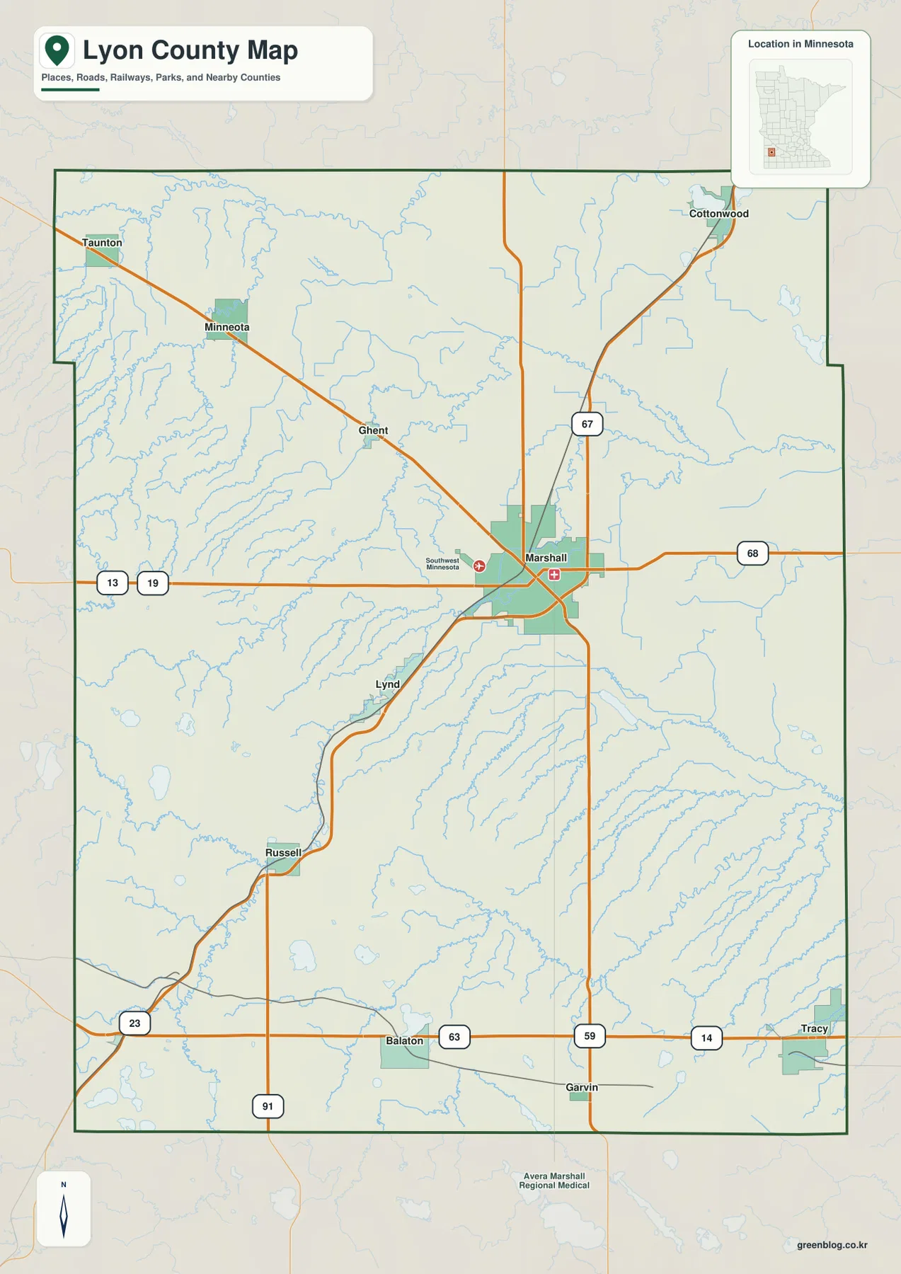
Use this view when the reader needs several layers at once. It works well for explaining where Marshall sits in relation to Tracy or Minneota, identifying the main road corridors, or placing Lyon County next to the counties that surround it. More specialized maps below remove some of that information so one subject can stand out.
A cleaner city view for comparing six communities
The city map reduces much of the road and place-name detail so the six highlighted communities are easier to compare. Marshall, Tracy, Minneota, Cottonwood, Balaton, and Ghent are marked clearly within the county outline, making the map useful for classroom explanations, local presentations, or a quick overview of settlement distribution.
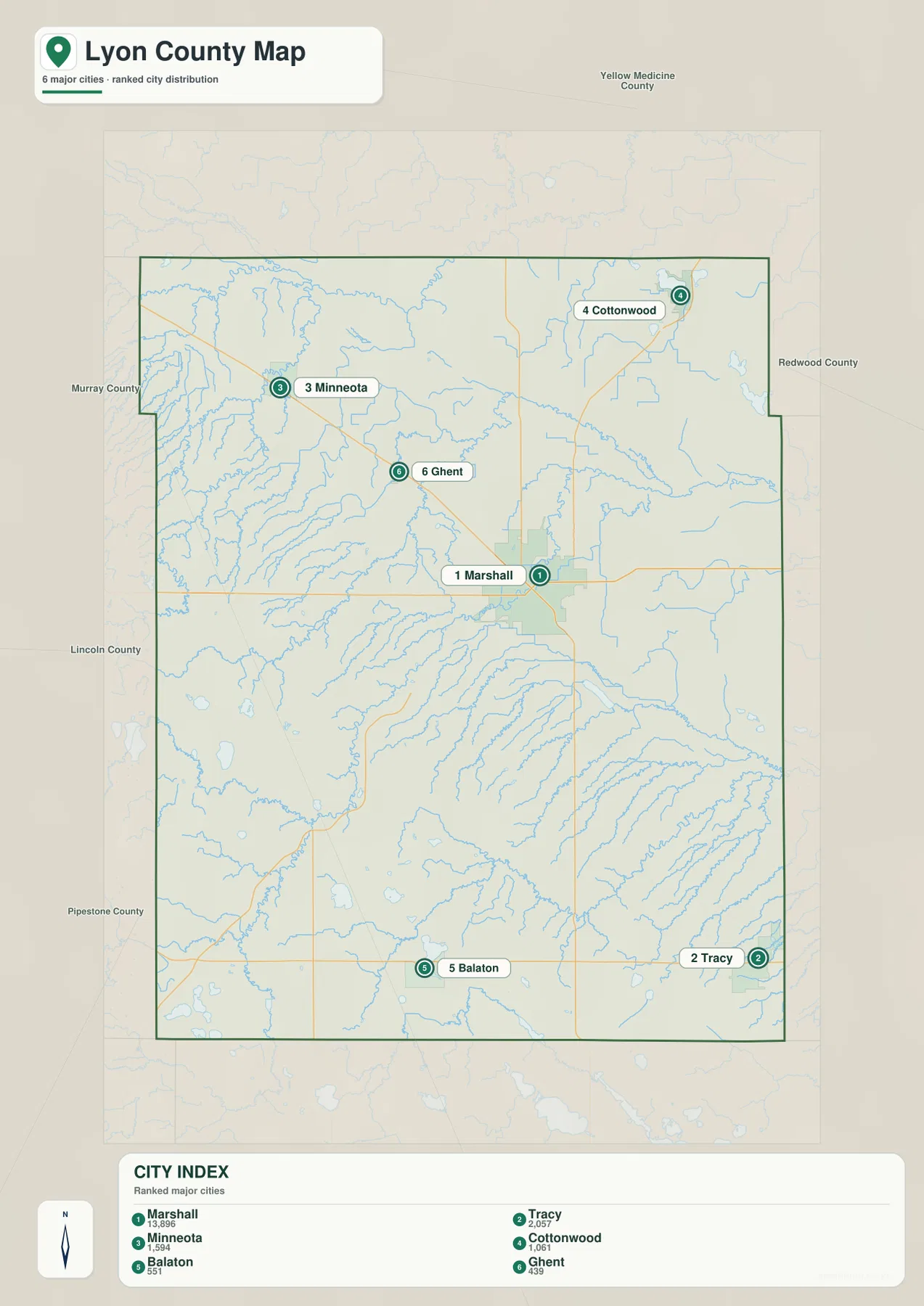
The spacing between markers should be read as map position, not as a substitute for road mileage or travel time. When an actual route matters, compare this image with the county reference map, which shows the principal highways and additional towns between the highlighted communities.
A water-focused view of rivers, creeks, and small lakes
The terrain-and-water map gives the strongest visual emphasis to the Yellow Medicine, Redwood, and Cottonwood river systems. It also labels Three Mile Creek and Meadow Creek and makes several small lakes easier to locate than they are on the road-oriented reference map.
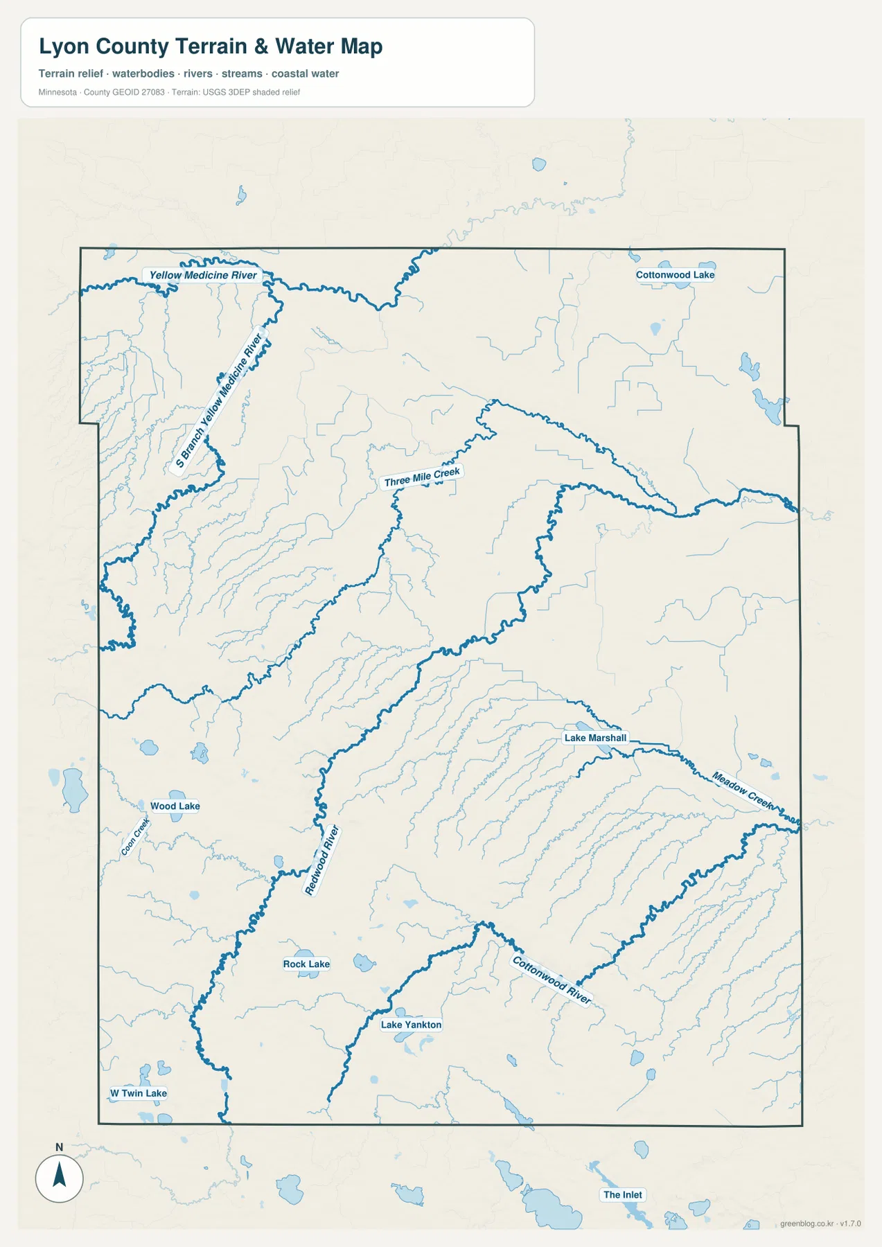
This image is a geographic reference, not a flood map, parcel product, shoreline-regulation map, or navigation chart. Flood risk, regulated waters, channel conditions, and legal boundaries require the current records of the appropriate local, state, or federal agency.
An elevation view centered on the southwest-to-northeast change
The elevation map removes most roads and town labels so the land surface becomes the subject. Higher southwestern terrain is shown with warmer colors, while lower northern and northeastern areas appear greener. Relief shading makes valleys and subtle ridges visible through the transition zone.
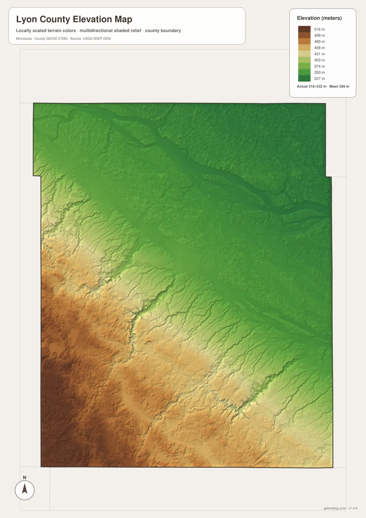
This is the most useful view for seeing the county’s broad relief at a glance. Pairing it with the water map can clarify why streams occupy particular low corridors, while the general map is better when road names and community locations are the primary concern.
Choosing the right file for print, classwork, or local reference
For a one-page county handout, the general reference map offers the most balanced mix of towns, roads, surrounding counties, and water features. The city view is cleaner when the goal is to compare the positions of major communities. River and lake topics are easier to explain with the water map, while the elevation map is the better choice for discussions of relief and drainage.
Using two maps together can be more effective than forcing every subject into one graphic. The reference and city maps work well as a pair for settlement and transportation, while the water and elevation maps complement each other for natural geography. The downloadable A3 originals preserve more detail than the web previews and can be reduced for smaller print layouts when necessary.
Frequently Asked Questions
Where is Marshall within Lyon County?
Marshall is slightly east of the county’s center and is the strongest road and population reference on the supplied maps. Minneota and Ghent are northwest, Cottonwood is northeast, Balaton is south, and Tracy is farther southeast.
Which rivers stand out on the Lyon County water map?
The Yellow Medicine River and its South Branch are prominent in the north. The Redwood River occupies the southwest and western interior, while the Cottonwood River and Meadow Creek are major features in the southeast. Three Mile Creek and several named lakes provide additional references.
What is the clearest elevation pattern in Lyon County?
The southwest is generally higher, while the land becomes lower toward the north and northeast. The supplied legend shows an actual range of about 318 to 532 meters and a mean near 399 meters, which is appropriate for county-scale comparison rather than survey or engineering work.
References and official resources
County background and local mapping resources are available from the official Lyon County About Us page and the county’s Map Gallery. For road information, the Minnesota Department of Transportation Lyon County highway map provides an official transportation reference.
Water features can be checked against USGS National Hydrography, and elevation data are available through the USGS 3D Elevation Program. The maps on this page are intended for general geographic reference and do not replace legal boundary, flood, survey, navigation, or engineering products.
Map File Information
The ZIP archive contains the Lyon County reference map, city map, terrain-and-water map, and elevation map as high-resolution A3 JPG files for printing, teaching, presentations, and general local reference.
- Printable Size: High-resolution A3 layout
- File Type: Four JPG files in one ZIP archive
Related Maps
Green Map creates custom-edited map images using open geographic data sources such as geoBoundaries, Natural Earth, OpenStreetMap, and government open data. These maps are edited visual materials, not raw data files, and are provided for education, documents, presentations, and graphic reference.