Otsego County sits in the north-central part of Michigan’s Lower Peninsula, with Gaylord serving as the clearest road and settlement reference point. I-75 runs north and south through the county, M-32 crosses Gaylord from west to east, and Old US-27 continues toward Vanderbilt. The maps on this page focus on those roads, the county’s river headwaters, Otsego Lake, smaller inland lakes, and the contrast between higher uplands and lower stream valleys. The original A3 JPG map files used here are also available together in one downloadable ZIP.
The county is especially interesting because several drainage systems begin close to one another. The Sturgeon River, Pigeon River, and Black River appear in the northern and northeastern part of the water map, while Otsego Lake and the North Branch Au Sable River occupy the southern half. Elevation adds another layer: broad higher ground covers much of the southwest and south, while greener lowlands follow several northern and eastern river corridors. Reading these features together gives a better sense of Otsego County than treating it as a single flat block of northern Michigan.
Table of Contents
Gaylord sits where the county’s main north-south and east-west routes meet
Gaylord is the strongest visual anchor on the general county map. I-75 passes through the central part of Otsego County, and M-32 crosses the city from west to east. Old US-27 follows the same broad north-south corridor and continues toward Vanderbilt, creating an easy way to orient the two best-known settlements on the page. Around Gaylord, the road network is denser than it is in the northeastern interior, which makes the city stand out even before the label is read.
Vanderbilt lies north of Gaylord along the Old US-27 and I-75 corridor. Moving away from that corridor, the pattern changes quickly. The northeastern side of the county has fewer major through roads on the map and more branching local routes, while the southern and western portions show straighter roads around lakes, rural land, and the approaches to Gaylord. That contrast is useful when explaining why a short distance on the county map can lead from a developed service center into a much more lightly settled forest landscape.
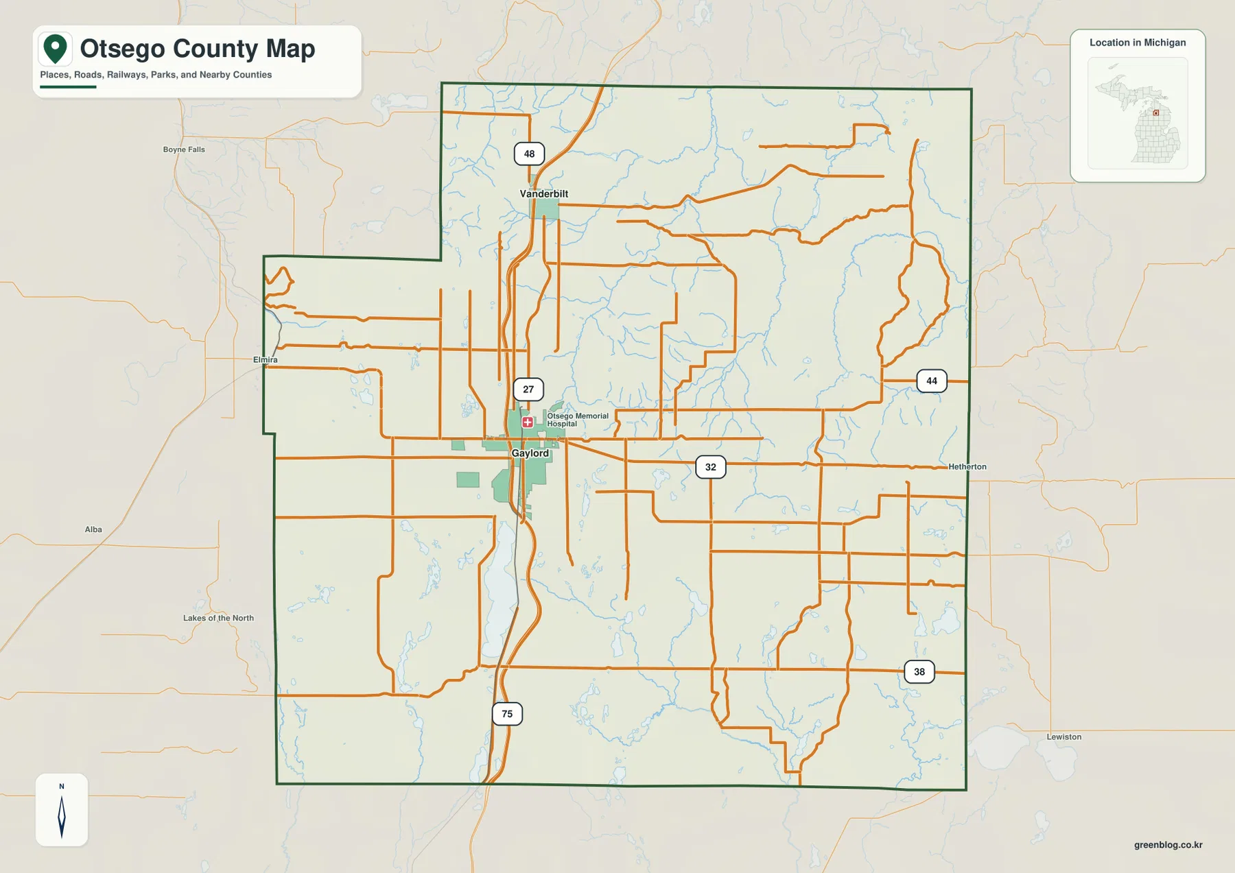
M-32 provides the clearest east-west reference through Gaylord. Roads continue toward Elmira on the west side and toward the eastern county line beyond the city, while nearby labels such as Boyne Falls and Lewiston help place Otsego County within the broader northern Lower Peninsula. Those outside labels are context rather than a complete list of neighboring communities. For navigation, construction closures, winter driving, or traffic conditions, this overview should be paired with a current road service rather than treated as a live route map.
The county boundary is mostly compact but is not a perfect rectangle. A noticeable step in the northwest side breaks the outline, while the southern edge is comparatively straight. That shape matters when comparing the road network with communities just outside the county. The general map is best used to understand where Gaylord, Vanderbilt, Otsego Lake, major highways, and broad river corridors sit in relation to the boundary, not to determine parcel lines or exact municipal limits.
The city index highlights Gaylord and Vanderbilt without implying a distance between them
The city index is intentionally simple. Gaylord is marked as number 1 and Vanderbilt as number 2, with the printed index showing values of 4,357 and 341. Those figures belong to the supplied map graphic and should not be treated as a substitute for the latest Census estimate. More importantly, there is no connector line or mileage figure between the two markers. The map shows relative position and ranking, not straight-line distance, driving distance, or travel time.
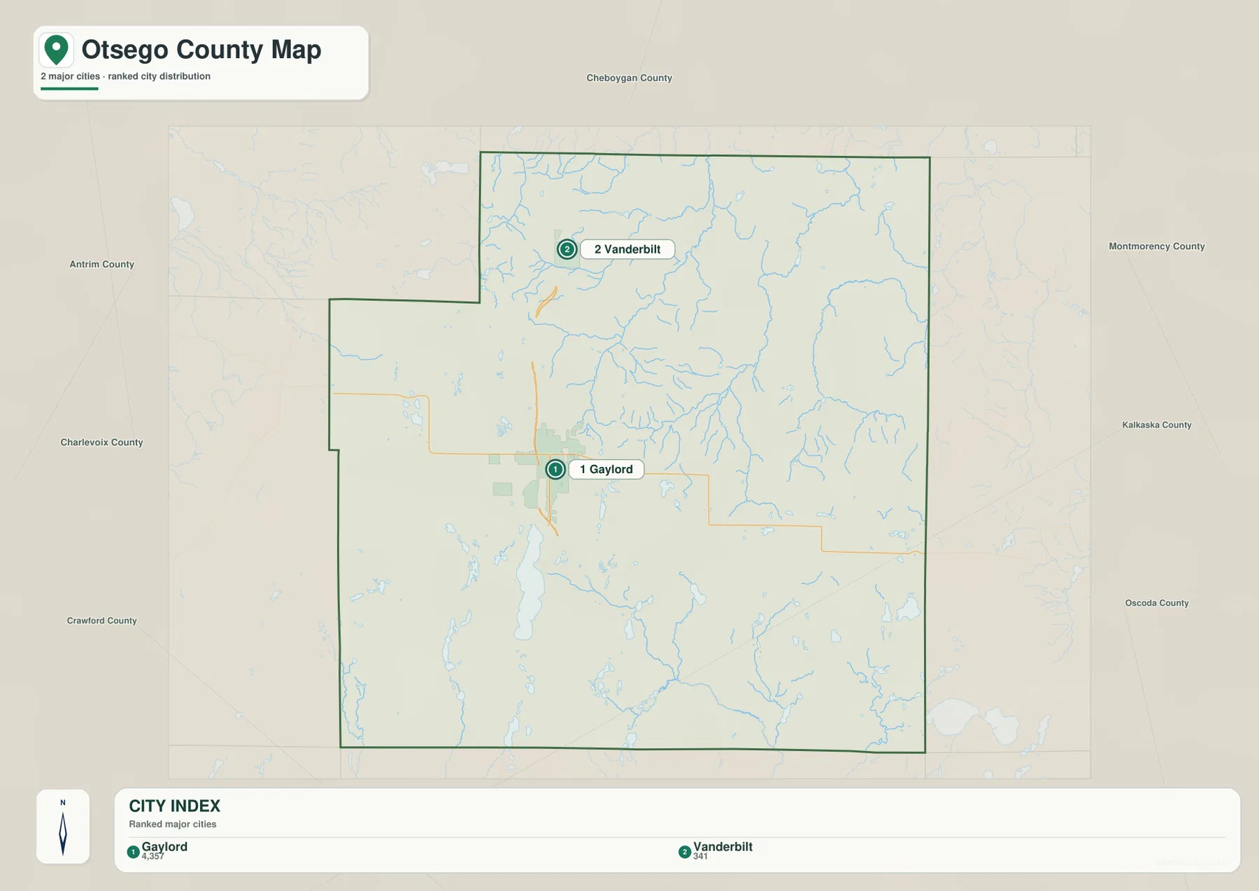
The “major cities” wording in the graphic is a generic map label rather than a statement that both places have the same legal status. Michigan’s official local codes identify Gaylord as a city and Vanderbilt as a village. The Library of Michigan also lists Elmira, Johannesburg, and Waters among Otsego County communities. In other words, the two-marker index is a selective visual summary. It works well when a reader wants a quick reference for the most prominent labeled settlements, but it is not a complete municipal or community directory.
Using the index together with the general map is more informative than using either alone. The index makes the north-south separation of Gaylord and Vanderbilt immediately obvious, while the road map explains how I-75 and Old US-27 relate to that pattern. Smaller communities require a more detailed local map, but the two-map comparison is enough for a county overview, a classroom handout, or a regional presentation where the main objective is orientation rather than street-level navigation.
Three northern river systems contrast with Otsego Lake and the Au Sable headwaters to the south
The northern half of the terrain-and-water map is crossed by several named rivers. The Sturgeon River runs through the north-central area, while the Pigeon River and Black River occupy the northeastern side. Numerous smaller tributaries feed those channels, creating a dense branching pattern across the forested interior. The rivers are close enough on a county-scale map to invite comparison, but each follows a separate valley and should not be read as one connected main stem.
West of the Sturgeon River, Club Stream is labeled among smaller headwater channels. Farther south, lakes become more prominent. Big Lake, Turtle Lake, Little Bear Lake, Crapo Lake, Guthrie Lake, Lake Manuka, and Lake Tecon are among the named waters shown on the map. Their sizes differ considerably, yet they are useful location references in areas where the road network is less visually dominant. Together they also show why a county known for forests can still have a very water-rich landscape.
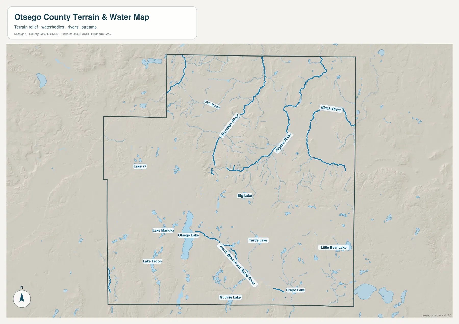
Otsego Lake is the most prominent lake on the southern half of the map. From the lake area, the North Branch Au Sable River runs southward, creating a striking contrast with the Sturgeon, Pigeon, and Black river systems farther north. The Visit Gaylord tourism office describes Otsego County as having more than 90 inland lakes and the headwaters of five rivers, and identifies Otsego Lake as the county’s largest lake. The supplied map does not label every lake or every headwater, but it clearly supports the broader picture of several drainage directions meeting within a relatively compact county.
This water map is a geographic reference, not a flood, depth, navigation, wetland-regulation, or property-access map. River and lake names can help a reader understand location, but they do not show safe boating routes, seasonal water levels, legal access points, or flood insurance zones. For those purposes, use current Michigan DNR, county, or federal resources. For a county overview, however, the map is especially effective at showing how the northern headwater rivers and southern lake-and-river system occupy different parts of Otsego County.
Higher southern and western uplands fall toward lower river corridors in the north and east
The elevation map changes the way the county reads. Browns and tan shades cover much of the southwest and south, indicating broad higher terrain, with additional ridges and knobs in the western and central portions. Green shades become more common across the north and northeast, where river valleys cut through lower ground. Gaylord sits near the transition between these zones rather than at either extreme, which helps explain why a road-centered city and several river headwaters can exist within a short distance of one another.
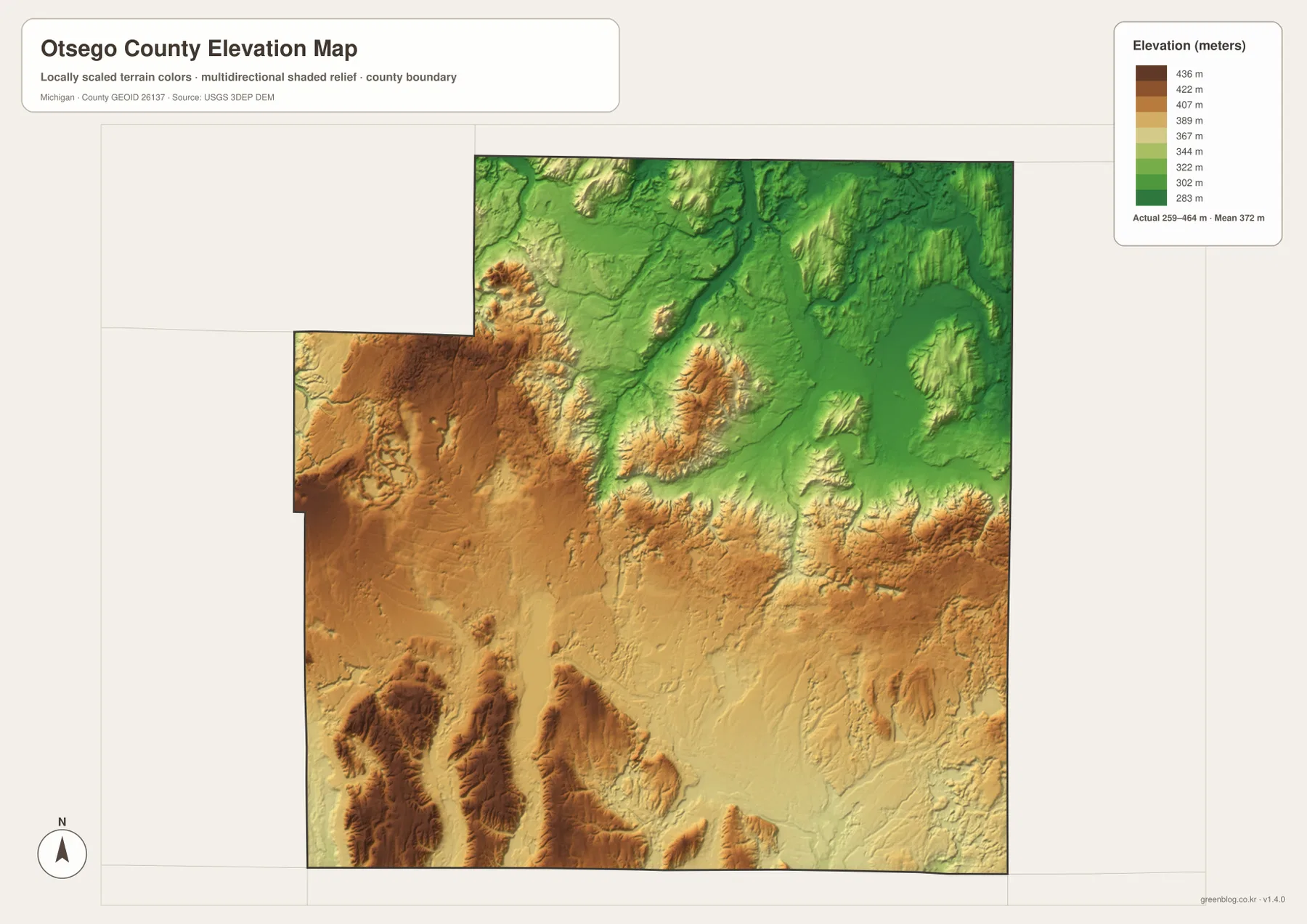
The legend uses representative color steps from roughly 283 to 436 meters, while a separate note on the map reports an actual surface range of about 259 to 464 meters and a mean near 372 meters. Those numbers should not be confused. The top value in the color legend is not necessarily the county’s exact highest point; the legend is a visual scale, while the separate range summarizes the underlying surface used for the map. This distinction is important when readers want to compare broad relief without assuming survey-level precision.
Comparing elevation with the water map makes the terrain easier to interpret. The Pigeon and Black river corridors follow lower green areas in the northeast, and the Sturgeon River also occupies ground below the higher southern uplands. Around Otsego Lake and the North Branch Au Sable River, lower terrain forms another distinct pathway through the southern part of the county. Higher ridges between these drainages help separate waters that eventually travel in different directions, although the generalized map is not intended to define precise watershed boundaries.
The elevation image is useful for regional explanation, education, and visual comparison. It should not be used for building elevations, road grades, drainage design, flood determinations, or boundary surveying. Those tasks require original elevation data, detailed contours, engineering products, or field measurements. For ordinary readers, the main takeaway is simpler: Otsego County has substantial relief, and the lower river corridors cut through a landscape that rises noticeably toward several western and southern uplands.
Otsego Lake and Pigeon River Country show two different sides of the county
South of Gaylord, Otsego Lake provides the clearest large-water reference on the county maps. Otsego County Parks operates Otsego Lake County Park on the lakeshore, while Michigan DNR manages Otsego Lake State Park nearby. The DNR describes the state park as a 62-acre lakeside recreation area with a sandy beach and access to the Iron Belle Trail. Those facilities are not drawn in detail on the supplied county maps, but the lake’s position helps readers connect Gaylord’s road network with a major recreation area immediately to the south.
The northeastern side tells a different story. Michigan DNR describes Pigeon River Country State Forest as a 109,000-acre backcountry area a few miles northeast of Gaylord and notes that it extends across Otsego and neighboring counties. That context fits the water map, where the Pigeon River and Black River are among the most prominent named features in the northeastern interior. The county map on this page does not attempt to show the state forest boundary, trails, campgrounds, or elk-viewing areas, so visitors should use the dedicated DNR map for recreation planning.
The Library of Michigan lists nine townships in Otsego County—Bagley, Charlton, Chester, Corwith, Dover, Elmira, Hayes, Livingston, and Otsego Lake—and names communities including Gaylord, Vanderbilt, Elmira, Johannesburg, and Waters. The supplied maps deliberately emphasize broader geographic relationships instead of every township boundary and community label. That makes them useful for explaining the county’s shape, principal roads, major waters, and terrain while leaving administrative detail to official local maps.
Choose the map by whether you need roads, water, or relief
For a first look at Otsego County, the general map is the most complete single image because it combines the boundary, Gaylord, Vanderbilt, I-75, M-32, Old US-27, local roads, and surrounding place context. The city index is better when the goal is simply to emphasize the two ranked settlement markers. It should not be used for mileage because no distance connector is shown. The terrain-and-water map is the clearest choice for the Sturgeon, Pigeon, and Black rivers, Otsego Lake, the North Branch Au Sable River, and the county’s many smaller named lakes.
The elevation map becomes most useful when paired with the water map. It shows why several rivers occupy lower corridors and why the county’s southern and western sections have a different landform character from parts of the north and northeast. The downloadable ZIP contains the original JPG versions of the general county map, city index, terrain-and-water map, and elevation map used on this page. Each image is 3638 × 2572 pixels in an A3 landscape format, suitable for large-screen viewing and many classroom or presentation uses.
These maps are reference graphics rather than legal, engineering, emergency-response, or real-time navigation products. Use Census TIGER/Line data for authoritative boundary work, USGS National Hydrography for detailed water data, and the USGS 3D Elevation Program for original elevation resources. When planning a park visit or outdoor activity, check current Otsego County and Michigan DNR information as well. The maps are most valuable when the goal is to understand the county quickly and communicate its main geographic features clearly.
Frequently Asked Questions
Does the city index show the distance between Gaylord and Vanderbilt?
No. The city index marks Gaylord as number 1 and Vanderbilt as number 2, but it does not draw a connector line or print a mileage value. It is meant to show relative position and ranking. For driving distance, travel time, or route conditions, use a current navigation or road service that can account for I-75, Old US-27, closures, and seasonal conditions.
Which map best shows Otsego Lake and the northern river headwaters?
The terrain-and-water map is the best choice. It labels Otsego Lake and the North Branch Au Sable River in the south, while the Sturgeon River, Pigeon River, and Black River are prominent across the north and northeast. Smaller lakes are also named, making this version the clearest single view for comparing the county’s different drainage areas.
Can the 259–464 meter elevation range be used as survey data?
No. The range printed on the elevation map summarizes the generalized surface used for a county-scale graphic, and the mean is shown near 372 meters. The map is useful for seeing higher southern and western uplands versus lower northern and eastern valleys, but exact site elevations require detailed USGS data or professional field measurements.
Map File Information
Download the high-resolution JPG maps used on this page as one ZIP file for Otsego County.
- Included Files: county map, city map, terrain and water map, elevation map
- File Type: ZIP containing 4 JPG files
Related Maps
Sources and references
- Otsego County, Michigan — official county information and local services
- Otsego County Parks & Recreation — county parks, including Otsego Lake County Park
- Library of Michigan – Otsego County — county history, townships, and communities
- Michigan DNR – Pigeon River Country State Forest — forest, recreation, and regional context
- U.S. Census Bureau – TIGER/Line Shapefiles — county boundaries and geographic data
- U.S. Geological Survey – National Hydrography — rivers, streams, and lake reference data
- U.S. Geological Survey – 3D Elevation Program — elevation data and terrain reference
Green Map creates custom-edited map images using open geographic data sources such as geoBoundaries, Natural Earth, OpenStreetMap, and government open data. These maps are edited visual materials, not raw data files, and are provided for education, documents, presentations, and graphic reference.