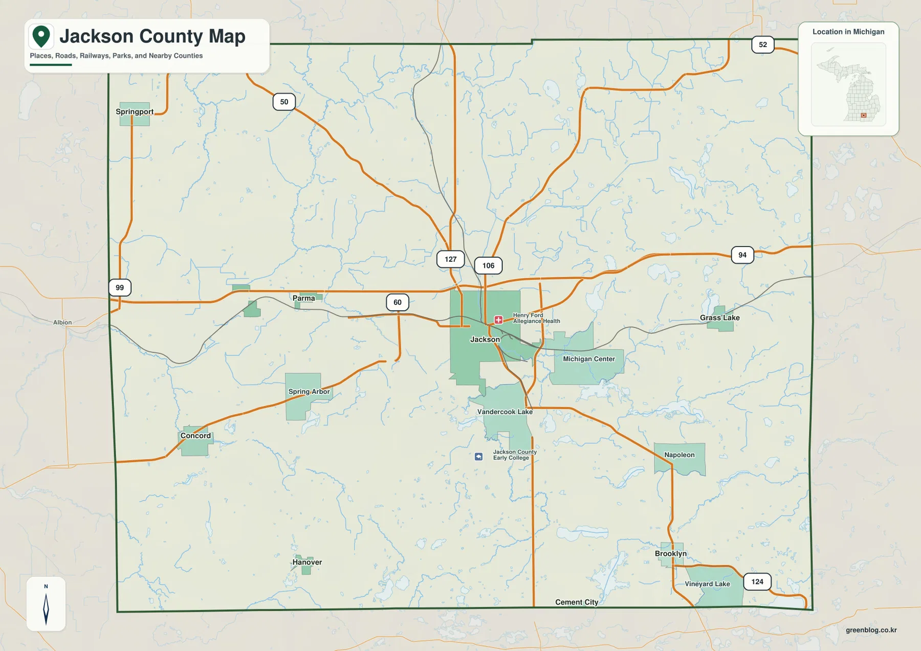
Jackson County sits in southern Michigan, with the city of Jackson forming the clearest geographic anchor where the I-94 east-west corridor meets the US-127 north-south route. The county becomes more dispersed away from that center: Parma and Concord lie to the west, Grass Lake and Michigan Center are to the east, and Napoleon and Brooklyn occupy the southeast. Rivers and lakes add another layer of orientation, especially in the southern and eastern sections. This page brings those features together through a general county map, a ranked city distribution map, a terrain-and-water map, and an elevation map, with matching high-resolution JPG files available in one downloadable ZIP.
Jackson County’s official website highlights a region with many lakes, parks, and separate communities, and that description is easy to recognize on the maps. Roads and built-up areas are densest around Jackson, while the southern half contains numerous named lakes and smaller settlements. To the west, Spring Arbor, Concord, Hanover, Parma, and Springport provide distinct reference points rather than one continuous urban area. Reading the county successfully therefore means combining the road network with water and relief instead of treating Jackson city as the only useful landmark.
Table of Contents
Jackson and the I-94–US-127 junction establish the county’s main road framework
The general county map places Jackson slightly north of the geographic center and gives it the largest developed footprint. I-94 crosses the county from west to east just north of the city core, while US-127 provides the strongest north-south reference. Together they make Jackson an efficient starting point for locating other communities. Parma lies west of the city near the I-94 corridor, Grass Lake is farther east, and Michigan Center sits southeast of Jackson between the city and the eastern lake country.
South of Jackson, the settlement pattern spreads into several smaller places. Vandercook Lake adjoins the southern side of the city area, Napoleon appears farther southeast, and Brooklyn lies near the lower-right portion of the county. Cement City and Vineyard Lake sit close to the southern boundary, while Hanover is shown in the southwest. These locations are less dependent on one dominant freeway than central Jackson, so local roads and nearby lakes become more useful for orientation.
The western half has its own set of anchors. Spring Arbor is southwest of Jackson, Concord is farther west, and Springport sits near the northwest boundary. Numbered state routes such as M-50, M-60, M-99, M-106, and M-124 supplement I-94 and US-127 across parts of the county. Their value on this map is practical: a reader can first find the nearest major corridor, then use a smaller route and a community name to narrow the location without needing every local street.
Eastern Jackson County is organized differently. Grass Lake lies near the I-94 corridor, Michigan Center is closer to Jackson and farther south, and lake-dotted rural areas separate many of the built-up places. Napoleon and Brooklyn extend the settlement pattern toward the southeast rather than continuing one straight east-west line. Looking at these communities together makes the county feel less like a single metropolitan extension and more like a central city surrounded by multiple smaller towns, villages, and lake communities.
The ranked city map shows a dominant Jackson surrounded by five much smaller centers
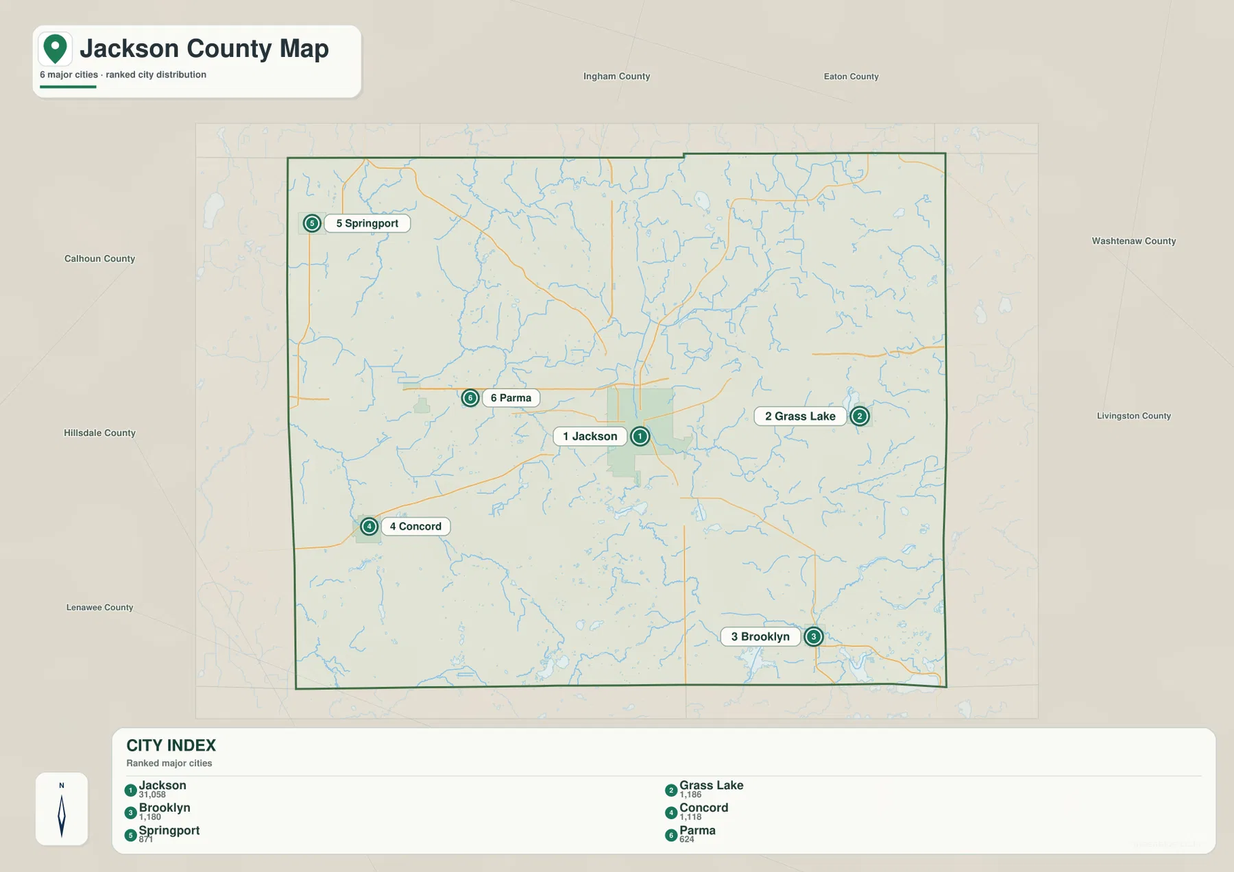
The city distribution graphic ranks six places and makes the scale difference immediately visible. The values printed on the map are Jackson 31,058, Grass Lake 1,186, Brooklyn 1,180, Concord 1,118, Springport 871, and Parma 624. They should be treated as the map’s ranking values rather than a substitute for the latest Census estimate. Their main purpose here is to show how much larger Jackson is than the other labeled communities while still preserving the geographic importance of those smaller places around the county.
The six locations are spread across nearly every side of the county. Grass Lake is east of Jackson, Brooklyn is southeast, Concord is southwest, Springport is northwest, and Parma is west. That distribution helps explain why one road does not connect all of the important places in a simple sequence. A trip toward Springport uses a very different direction from a trip toward Brooklyn, even though both begin from the same central reference point in Jackson.
This graphic does not draw straight-line connectors or provide mileage between the places. It is best used for relative position, not travel distance. The surrounding county labels add regional context: Grass Lake lies toward Washtenaw County, Springport toward the Calhoun and Eaton side, and Brooklyn toward the southern and southeastern part of Jackson County. For driving distance or route time, current navigation data is still necessary, but for a quick understanding of where the county’s principal named communities are distributed, the ranking map is effective.
Grand, Kalamazoo, Raisin, and Portage waterways divide the county into several drainage areas
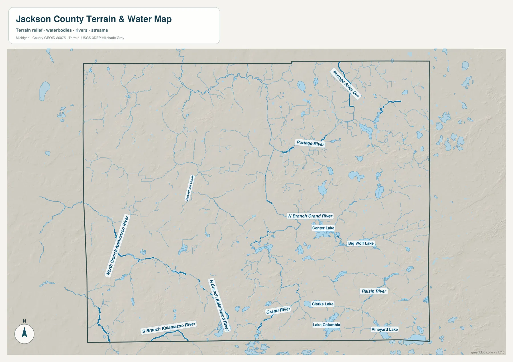
The terrain-and-water map reveals a county crossed by several different river systems rather than one single trunk stream. North Branch Grand River and Grand River appear through the central and south-central area. Farther southwest, North Branch Kalamazoo River and South Branch Kalamazoo River form a separate network. Raisin River is labeled in the southeast, while Portage River and Portage River Drain identify a different waterway system in the northeast. These names create useful geographic zones that complement the road map.
Lakes are especially conspicuous across the eastern and southern half. Center Lake and Big Wolf Lake sit in the east-central area, Clarks Lake lies farther south, Lake Columbia is near the southern boundary, and Vineyard Lake appears near the southeast edge. Many smaller unnamed or less prominently labeled water bodies surround them. This concentration helps distinguish the Brooklyn, Napoleon, and eastern lake country from the more road-oriented Jackson core.
The western side has a different hydrologic character. Sandstone Creek is labeled west of the center, and the two Kalamazoo River branches become important references toward the southwest. Comparing them with the Grand River system shows that the western and central parts of Jackson County do not all drain through the same mapped channel. For a place near Concord or Hanover, knowing which creek or river branch is nearby can be more useful than simply describing the location as “west of Jackson.”
Portage River in the northeast and Raisin River in the southeast further separate the eastern side into recognizable sections. The official county overview also emphasizes the large number of lakes in Jackson County, which fits the dense pattern of blue water bodies visible here. This map is intended for geographic reference, however. It does not show current flood stage, water depth, navigability, fishing rules, or legal access, so those questions require current information from the appropriate agency or land manager.
Elevation from about 271 to 358 meters highlights the high southwest and lower central corridors
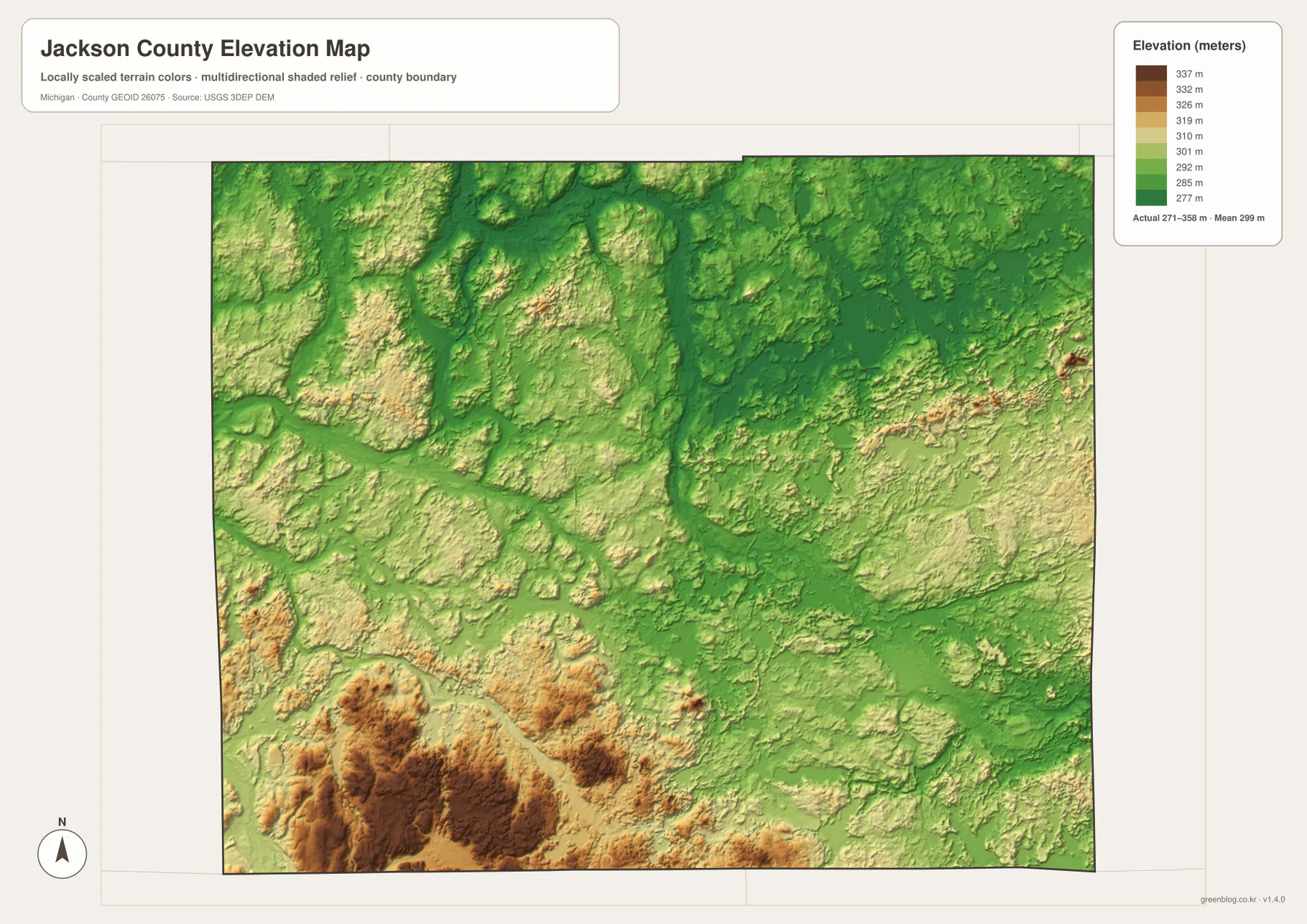
The elevation map reports an actual displayed range of about 271 to 358 meters, with a mean near 299 meters. Green represents lower ground, while yellow, tan, and brown indicate progressively higher terrain. The strongest concentration of dark brown appears in the southwest, where a broad group of hills stands above much of the county. Additional raised terrain appears in the northwest and in smaller pockets toward the eastern edge, but the southwest is the clearest high-relief area.
The high southwest is not a flat plateau. Lower valleys and narrow green corridors cut between the ridges, giving the terrain a broken appearance. Those depressions often correspond with creeks or river branches visible on the water map. Concord and Hanover sit in a part of the county where this relief is much more obvious than it is around central Jackson. The comparison helps explain why a simple road map can understate how varied the western and southwestern landscape actually is.
Much of the central and north-central county appears in greener, lower tones. Jackson itself occupies mixed moderate terrain rather than one of the darkest high areas. The east is also mostly moderate but includes small ridges, low lake basins, and a few locally higher patches. Grass Lake and the southeastern lake district therefore should not be described as perfectly flat; the map shows repeated local changes even where the broad colors remain green to yellow.
The 271- and 358-meter figures describe the range of a generalized county-scale elevation surface, not surveyed elevations for individual parcels, roads, or buildings. Shaded relief is useful for recognizing large terrain contrasts and valley patterns, but it is not an engineering or legal measurement product. Construction, drainage design, slope calculation, and other precise applications should use source elevation data or professional surveying. For ordinary geographic reading, the map clearly communicates the contrast between the elevated southwest and the lower central corridors.
Use roads for the first location check, then add water or relief when the place is less obvious
When a location is described by a town or highway, the general county map is the most efficient starting point. Jackson provides the central reference, I-94 organizes the east-west direction, and US-127 establishes the north-south frame. From there, Parma and Concord lead the eye west, Grass Lake and Michigan Center lead east, and Napoleon and Brooklyn move the search into the southeast. The ranked city map is useful as a second view when the question is simply how the major named communities are distributed around Jackson.
For a river or lake reference, the terrain-and-water map is more direct. Grand River and its north branch help identify the central and south-central area, the Kalamazoo River branches distinguish the southwest, and Raisin River marks the southeast. Center Lake, Big Wolf Lake, Clarks Lake, Lake Columbia, and Vineyard Lake add more precise anchors within the lake-rich southern half. Pairing one of those names with a nearby town is often enough to narrow a location substantially.
If the description depends on high or low ground, begin with the elevation map. The high southwestern block, central green corridors, and smaller eastern ridges offer a quick terrain framework before roads are added. The WebP images in the article are 1800 × 1273 pixels for efficient on-screen viewing. The downloadable JPG files are 3638 × 2572 pixels each, providing more room to enlarge small labels or print the maps at a larger size.
Each map has a distinct role without replacing the others. The general map is best for communities, roads, and the county boundary; the ranked city graphic shows the distribution of the six highlighted places; the water map identifies rivers, creeks, and lakes; and the elevation surface explains the southwest-to-central relief contrast. For example, a reader looking for Brooklyn can first find it in the southeast on the road map and then use Lake Columbia, Vineyard Lake, and the surrounding terrain to understand the local setting more precisely.
Frequently Asked Questions
Where are Grass Lake and Brooklyn relative to Jackson?
Grass Lake is east of Jackson near the I-94 corridor, while Brooklyn is southeast in the lake-rich southern part of the county. The ranked city map shows their relative positions but does not provide straight-line or driving mileage. For trip planning, current navigation information should be used because road distance and travel time depend on the exact starting point and route.
Which map is best for seeing Grand River and the southern lakes together?
The terrain-and-water map is the clearest choice. It labels North Branch Grand River and Grand River along with Center Lake, Big Wolf Lake, Clarks Lake, Lake Columbia, Vineyard Lake, and other waterways. If roads and communities are also important, compare it with the general county map to place those water features relative to Jackson, Napoleon, Brooklyn, and the main highway network.
What files are included in the Jackson County map download?
The ZIP contains four high-resolution JPG files: the general county map, the ranked city distribution map, the terrain-and-water map, and the elevation map. Each image is 3638 × 2572 pixels. The water map is not intended for flood or navigation decisions, and the elevation map is not survey-grade, so specialized work should rely on the appropriate current official source.
Map File Information
Download the map files associated with this page for reference, printing, and compatible visual projects.
- Included Files: Use only the versions confirmed in the article and supplied images
- File Type: Use the confirmed download contents
- Intended Use: Printing, education, presentations, and map-based projects
Related Maps
Sources and References
The resources below provide official county background and source information for boundary, hydrography, and elevation mapping. These maps are designed for county-scale geographic reference. Legal boundaries, current flood conditions, exact elevations, engineering work, and similar specialized decisions should be checked against the latest purpose-specific agency data.
- Jackson County, Michigan official website – county government, GIS, parks, transportation, and local services
- Jackson County Official Greeting – overview of the county’s lakes, parks, education, and community features
- U.S. Census Bureau TIGER/Line Shapefiles – county boundary and geographic data
- USGS National Hydrography – rivers, streams, lakes, and related hydrography data
- USGS 3D Elevation Program – elevation data
Green Map creates custom-edited map images using open geographic data sources such as geoBoundaries, Natural Earth, OpenStreetMap, and government open data. These maps are edited visual materials, not raw data files, and are provided for education, documents, presentations, and graphic reference.