Iron County occupies a broad part of the western Upper Peninsula of Michigan along the Wisconsin border. Iron River and Crystal Falls provide two easy reference points on the southern US-2 corridor, while Amasa sits much farther north along US-141. Beyond the roads, the county is defined by an extensive network of rivers, lakes, and wooded uplands: the Michigamme River and Reservoir dominate the eastern water map, the Brule and Menominee rivers follow parts of the southern edge, and higher ground becomes especially prominent in the west and north. The maps on this page can be viewed online, and the same four subjects are available as high-resolution JPG files in a downloadable ZIP.
Iron County’s official website describes the county as a Wisconsin-border community in Michigan’s Upper Peninsula that was organized in 1885, with mining and logging central to its early development. The modern map still has a spacious, rural appearance: the larger settlements do not form one continuous built-up strip, and long stretches of forest, streams, and lakes separate them. Iron River, Caspian, and Gaastra form a close western cluster; Crystal Falls stands apart to the east; Alpha is smaller and farther south; and Amasa marks the northern US-141 corridor. Looking at those communities together with the water and elevation maps gives a much clearer picture than roads alone.
Table of Contents
US-2 ties Iron River and Crystal Falls together across the southern half
The general county map is easiest to enter through US-2, which crosses the southern portion of Iron County from west to east. It passes the Iron River area and continues toward Crystal Falls, creating a practical reference between the county’s two largest mapped centers. Near Iron River, M-73 and M-189 help establish north-south orientation, while US-141 turns north from the Crystal Falls side toward Amasa. Local roads branch from these routes, but the county is large enough that following every minor line from the beginning can be confusing. Starting with US-2 and US-141 makes the overall layout much simpler.
Iron River is closely grouped with Caspian and Gaastra in the southwest. Their developed areas appear near one another, so they read as a compact cluster compared with the rest of the county. Crystal Falls is well to the east and is also marked with the Iron County courthouse, making it another strong visual anchor. Alpha appears southeast of the main western cluster, while Amasa is separated from all of them by a long northward stretch of US-141. This arrangement makes Iron County look less like a county organized around one central city and more like several distinct community areas joined by a few major roads.
The southern boundary is another useful clue because it is far from a simple straight line. Iron County’s official description places the county along Wisconsin, and the map shows a winding state edge shaped in part by the river landscape. M-189 runs south from the Iron River area toward that border, while the southeastern side approaches the Menominee River corridor. For quick orientation, a reader can combine the US-2 line, the US-141 northward branch, the Iron River–Caspian–Gaastra cluster, Crystal Falls, and the irregular Wisconsin boundary before turning to smaller road names.
Five ranked communities reveal a western cluster and a separate Crystal Falls center
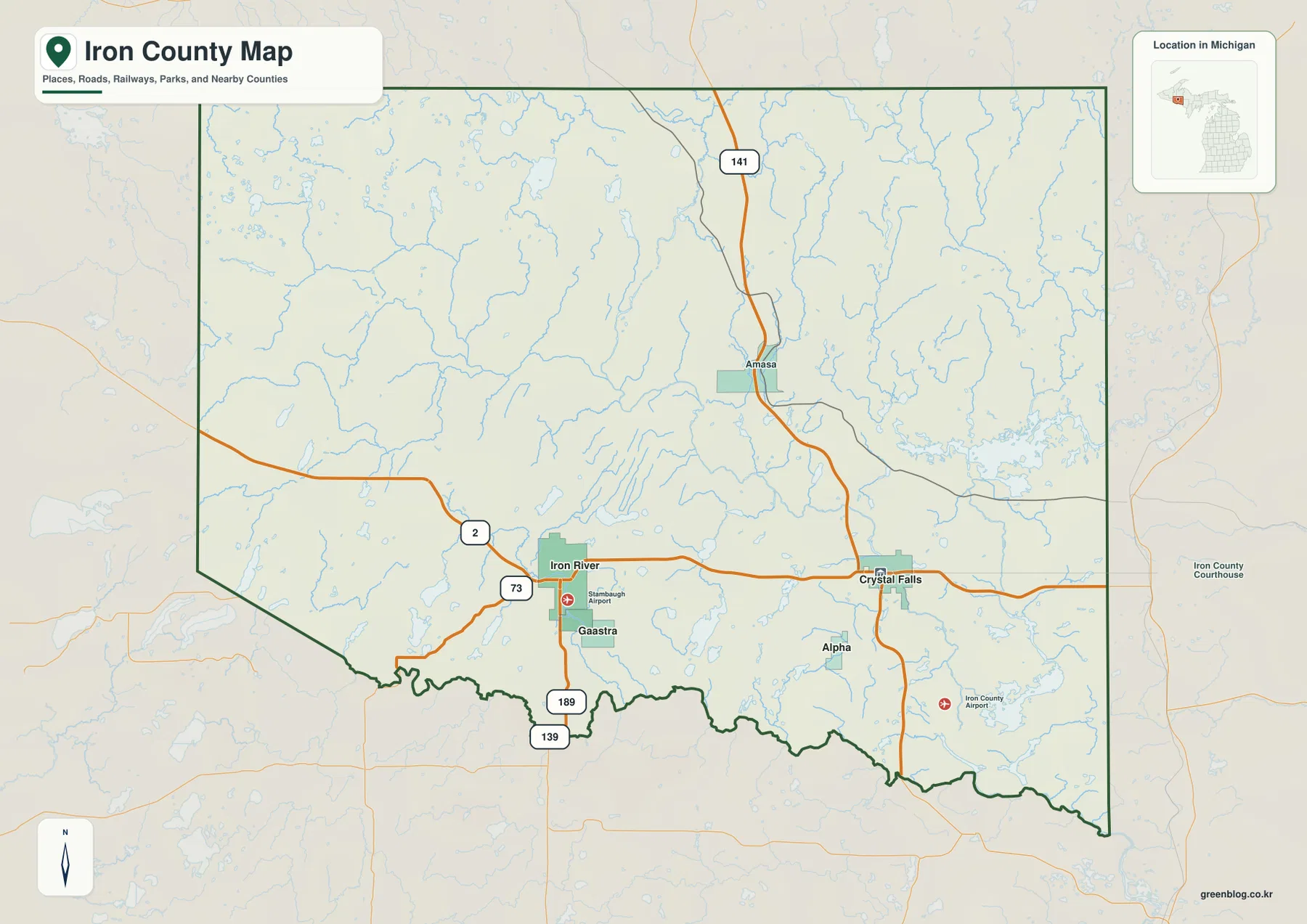
The city-distribution map highlights Iron River, Crystal Falls, Caspian, Gaastra, and Alpha. Values printed on the graphic are 3,002 for Iron River, 1,719 for Crystal Falls, 600 for Caspian, 296 for Gaastra, and 215 for Alpha. These figures belong to the dataset used for this map and should not be treated as a live population count; anyone who needs the latest official number should check the U.S. Census Bureau source listed below. For orientation, the map’s value is in showing how the five places compare in relative prominence and where they sit inside the county.
Iron River, Caspian, and Gaastra are concentrated in the southwest, with only short map distances separating the three labels. Iron River is the strongest reference in that group. Crystal Falls, by contrast, stands well to the east and creates a second center along US-2. Alpha is smaller and lies south of the main road corridor near the Crystal Falls side. The pattern matters because a location described as being near Iron River belongs to a very different part of the county from one described as being near Crystal Falls, even though both are reached from the same broad east-west highway.
Amasa does not appear among the five ranked communities, but it remains important on the general map because it marks the northern US-141 corridor. That difference illustrates why the city map and the road map work best together. The ranked graphic emphasizes the most prominent population centers, while the general map restores smaller places that are useful for geographic orientation. When a local name is unfamiliar, a practical sequence is to identify the nearest ranked community first, then use Amasa or another smaller label, a highway, and a nearby river or lake to narrow the location further.
The Michigamme system and the Brule–Menominee border rivers shape the water map
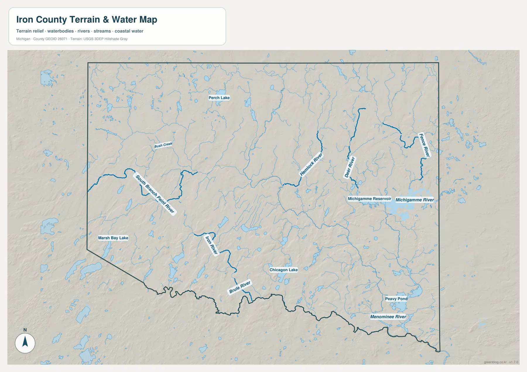
The eastern half of the terrain-and-water map is dominated by the Michigamme River and Michigamme Reservoir. The river curves through the east-central county, while the reservoir creates a broad water body that is easy to recognize even at a reduced map size. Farther north and northeast, the Fence River, Deer River, and Hemlock River descend through separate valleys. These named waterways help explain why the eastern interior looks more intricate than it does on the road-focused map: many of the visible breaks in the terrain follow rivers rather than transportation routes.
The western and central sections have a different set of landmarks. South Branch Paint River crosses the west-central area, and the Iron River itself appears farther south as it approaches the state boundary. Perch Lake provides a northern lake reference, Marsh Bay Lake sits near the southwest, and Chicagon Lake stands out closer to the middle of the county. None of those water bodies is as dominant as the Michigamme system, but they are valuable for local orientation. In large forested areas with relatively few major roads, a named lake or stream can distinguish one part of the county from another more effectively than a minor road line.
Along the south, the Brule River and Menominee River are especially important because the map shows them following parts of the Wisconsin boundary. The Brule appears across the south-central edge, while the Menominee bends along the southeastern side. Peavy Pond is labeled near the eastern end of this river system. Together, these features create a clear contrast with the interior streams: Iron County does not drain toward one single river corridor. The western tributaries, the eastern Michigamme system, and the southern Brule–Menominee rivers organize different parts of the county.
This is a geographic reference map rather than a flood, navigation, fishing-regulation, or property-access map. A blue stream line confirms the mapped location of a watercourse, but it does not establish current depth, flood probability, boating suitability, or legal public access. Those questions require current purpose-specific agency information. For ordinary county orientation, the water map is very effective: it shows where Michigamme Reservoir sits relative to Crystal Falls, where Chicagon Lake falls between the southern community areas, and how the Brule and Menominee river corridors relate to the state boundary.
Elevation from about 339 to 574 meters separates western uplands from southeastern valleys
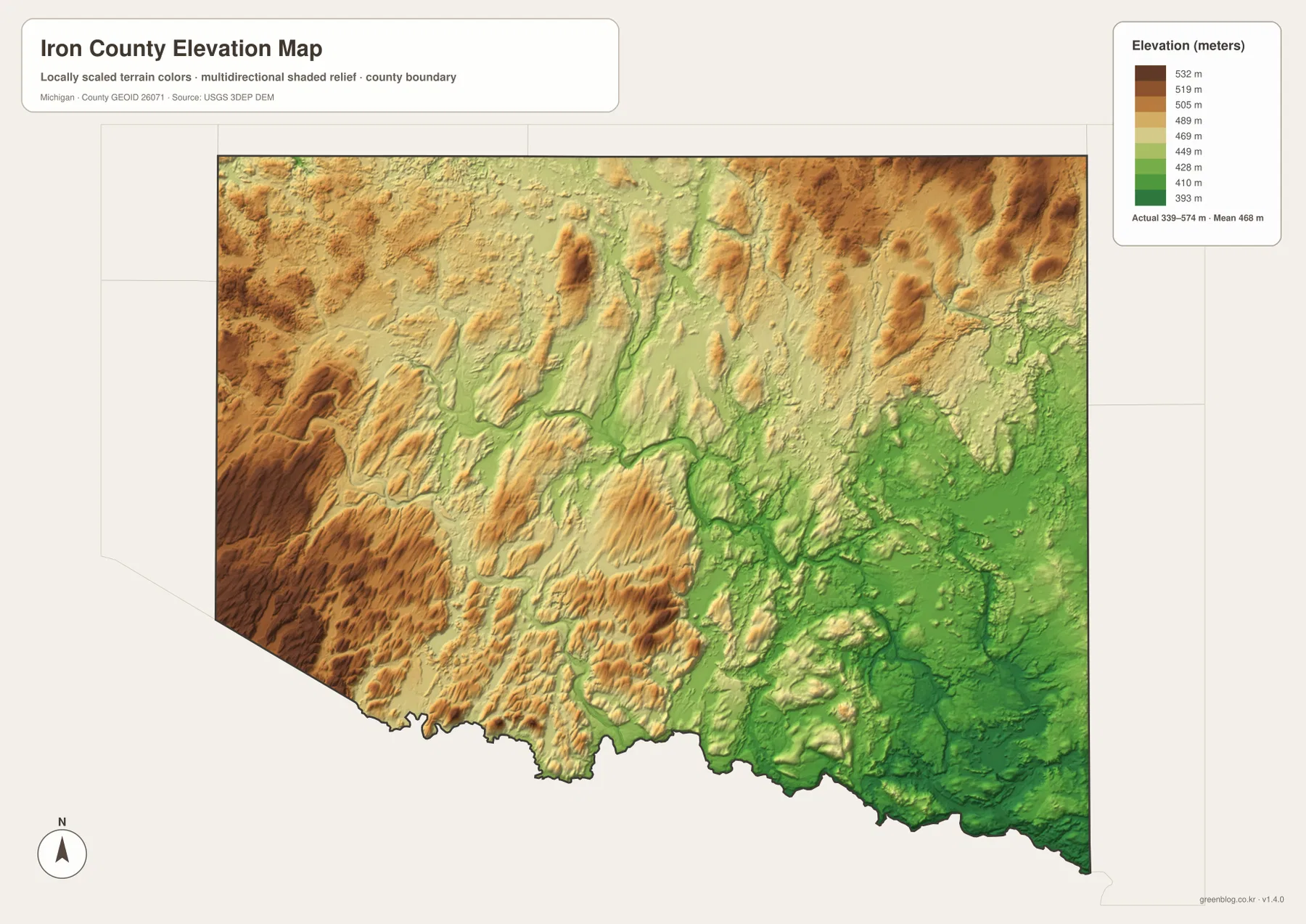
The elevation map reports an actual countywide range of roughly 339 to 574 meters, with a mean near 468 meters. Its locally scaled colors use green for lower ground and tan through brown for progressively higher terrain. The broadest high areas appear in the west and north, while greener lowlands become more extensive toward the east and southeast. The strongest contrast occurs where river valleys cut through the higher surface, especially in the Michigamme and Menominee portions of the county.
Western Iron County contains repeated ridges and uplands rather than one smooth plateau. The southwest also shows broad brown terrain broken by lower stream valleys. Across the center, elongated rises alternate with green channels, giving the surface a pronounced rolling form. Northern areas remain relatively high overall, yet narrow lower valleys extend inward along the drainage network. The southeastern corner has more continuous green terrain, which corresponds closely to the large river system seen on the water map.
The 339- and 574-meter values describe the displayed county-scale surface and are not survey elevations for a parcel, road, or building site. Shaded relief is generalized so the major differences in terrain remain visible at a regional scale. Construction, engineering drainage, precise slope calculations, and legal site work require source elevation data or professional surveying. For general map use, however, the surface communicates one important fact very clearly: the west and north are generally higher, while major river valleys create lower corridors toward the southeast.
Combining roads, rivers, and relief makes a large forested county easier to navigate
A practical way to use the set is to begin with the nearest major community and highway. Places near Iron River, Caspian, or Gaastra belong to the western US-2 area; locations near Crystal Falls or Alpha are farther east; and sites near Amasa are best approached from the US-141 corridor. After that first step, the water map can identify a nearby river, reservoir, or lake, and the elevation map can show whether the surrounding land belongs to the higher western terrain or one of the lower river valleys. This sequence is often faster than trying to interpret every minor road on one crowded map.
For example, a place east of Crystal Falls can be checked first against the US-2 and US-141 junction area and then compared with the Michigamme River and Reservoir. South of Iron River, M-189 and the Wisconsin boundary provide a stronger framework, with the Iron River watercourse and nearby lakes adding local clues. At the far southeastern side, the Menominee River and Peavy Pond become more useful than any western community name. Each part of Iron County has a different combination of reference points, which is why separate road, water, and elevation images are more readable than a single map overloaded with every feature.
The body images are 1800 × 1273 WebP files intended for efficient on-screen viewing. The ZIP contains 3638 × 2572 JPG versions, giving more room for printing or zooming into small labels. Use the general county map for roads, communities, and boundaries; the city-distribution map for the relative placement and prominence of the five ranked communities; the terrain-and-water map for named rivers, reservoirs, and lakes; and the elevation map for broad differences between uplands and river valleys. The four files can also be compared side by side when one subject alone does not provide enough context.
Frequently Asked Questions
How are Iron River and Crystal Falls connected on the county map?
Both communities lie along the southern US-2 corridor, but they are separated by a substantial rural stretch. Iron River is grouped closely with Caspian and Gaastra in the southwest, while Crystal Falls is farther east near the US-141 junction. Actual driving distance and travel time can vary with the chosen route and current conditions, so a current navigation service is appropriate for trip planning.
Which map is best for finding the Michigamme and Menominee rivers?
The terrain-and-water map is the clearest choice because it labels the Michigamme River and Reservoir, Deer River, Fence River, Brule River, Menominee River, Chicagon Lake, and Peavy Pond. If roads and towns are also important, compare it with the general county map to see those water features in relation to Crystal Falls, US-2, and US-141.
What is included in the Iron County map download?
The ZIP contains four high-resolution JPG files: the general county map, the ranked city-distribution map, the terrain-and-water map, and the elevation map. Each image is 3638 × 2572 pixels. The water image is not intended for flood or navigation decisions, and the elevation image is not survey-grade, so specialized work should rely on the appropriate current official source.
Map File Information
Download the map files associated with this page for reference, printing, and compatible visual projects.
- Included Files: Use only the versions confirmed in the article and supplied images
- File Type: Use the confirmed download contents
- Intended Use: Printing, education, presentations, and map-based projects
Related Maps
Sources and References
The official resources below provide county background, current statistics, and the source datasets used for boundary, hydrography, and elevation mapping. These maps are designed for county-scale geographic reference, so legal boundary questions, flood risk, exact elevations, and other specialized decisions should be checked against the latest purpose-specific agency data.
- Iron County, Michigan official website – county location, history, government, and local information
- U.S. Census Bureau QuickFacts: Iron County, Michigan – current population, area, and county statistics
- U.S. Census Bureau TIGER/Line Shapefiles – county boundary and geographic data
- USGS National Hydrography – rivers, streams, lakes, and related hydrography data
- USGS 3D Elevation Program – elevation data
Green Map creates custom-edited map images using open geographic data sources such as geoBoundaries, Natural Earth, OpenStreetMap, and government open data. These maps are edited visual materials, not raw data files, and are provided for education, documents, presentations, and graphic reference.