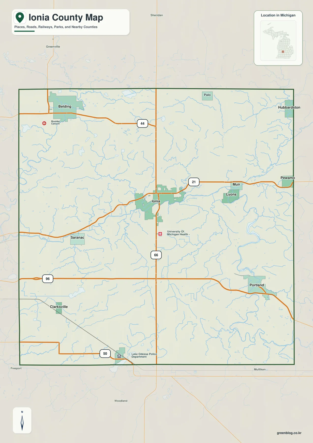
Ionia County sits in west-central Lower Michigan between the Grand Rapids and Lansing sides of the state, and its maps make sense fastest when Ionia is used as the central reference point. Belding is separated to the northwest, Portland is near the southeastern side, Lake Odessa is close to the southern boundary, and Saranac and Lyons occupy different parts of the east-west corridor. This page brings those communities together with the county boundary, major numbered roads, rivers, smaller streams, lakes, and relief. The same map set is also available as high-resolution JPG files in the download box below for printing or closer inspection.
The county government’s overview describes Ionia County as lying between Mid-Michigan and West Michigan and notes its rolling hills and tributaries connected with the Grand River. That description fits the supplied maps well. The road view shows several separated communities rather than one continuous urban belt, while the water map reveals a dense network centered on the Grand, Maple, Flat, and Looking Glass rivers. The elevation image then explains why those waterways matter visually: broad green lowlands follow the larger river valleys, with higher tan and brown ground rising around them. Reading the maps together turns a set of town names into a much clearer picture of the county.
Table of Contents
Start in Ionia, where the central road pattern is easiest to follow
Ionia is the best first landmark on the general county map because it sits close to the middle and is also the county seat. The route labeled 21 crosses the central part of the county, passing from the Saranac side through Ionia and continuing east toward Muir and Pewamo. Route 66 runs north-south through Ionia, giving the center a strong cross-county reference. Farther northwest, route 44 reaches the Belding area. In the southern half, route 96 passes through Portland, while route 50 appears near the Lake Odessa side of the southern boundary. The roads therefore form several useful local frames rather than a single countywide hub-and-spoke pattern.
The county edges help reinforce that orientation. Montcalm County is to the north, Clinton and Gratiot counties are on the eastern side, Kent and Barry counties are west of Ionia County, and Eaton County is along the southwestern side. Ionia County’s own planning material lists the same six neighboring counties. That context is especially useful near the edges, because Belding is much closer to the northwest side than to Portland, and Portland sits much closer to the southeastern boundary than to Belding. A reader who starts with the neighboring counties can usually tell which part of Ionia County a town or road label belongs to before looking at smaller features.
The overview also labels Muir, Lyons, Pewamo, Saranac, Clarksville, and Lake Odessa in addition to the larger built-up areas. Ionia and Belding are shown with visibly broader developed footprints, while Portland forms a separate cluster in the southeast. Muir and Lyons line up east of Ionia near route 21 and the river network. Saranac provides a western reference on the same general corridor, and Lake Odessa anchors the south. This dispersed arrangement is one of the county’s most useful map-reading clues: knowing the nearest community is often more helpful than trying to judge a location only from the rectangular county outline.
Six ranked communities show how widely the county’s population centers are separated
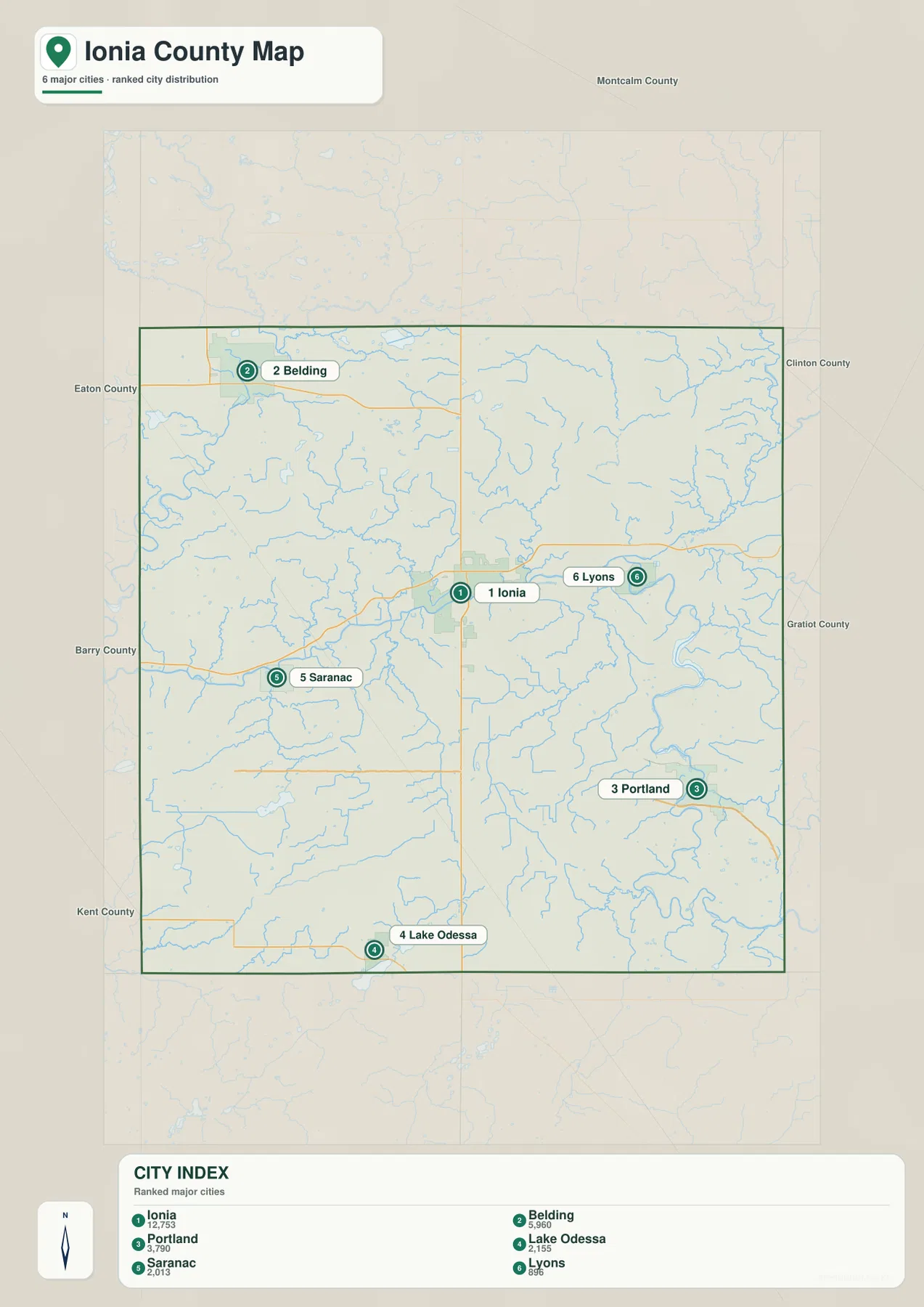
The city-distribution graphic highlights six communities and prints a comparison value for each one: Ionia 12,753, Belding 5,960, Portland 3,790, Lake Odessa 2,155, Saranac 2,013, and Lyons 896. Those figures are the values attached to this particular map and should not be treated as a live population counter; readers who need a current official estimate can use the U.S. Census Bureau source linked below. For map reading, however, the ranking is useful because it shows how strongly Ionia stands out among the six places and how Belding and Portland form the next two major reference points.
The geographic spacing matters just as much as the ranking. Belding is isolated in the northwest, Saranac lies west of the county center, Ionia occupies the middle, Lyons is east of Ionia, Portland is well to the southeast, and Lake Odessa is close to the southern edge. None of those places forms a continuous built-up strip with all the others. Large rural spaces, stream valleys, and local roads separate them. As a result, the county is easier to understand as a collection of distinct community areas connected by a few major roads than as a single urban corridor.
Pairing the city graphic with the road map makes each location more memorable. Ionia aligns with the crossing of routes 21 and 66; Belding relates most clearly to route 44 and the northwest corner; Portland is associated with route 96 and the southeastern Grand River bends. Saranac sits on the western approach toward Ionia, while Lyons lies east of the center near the main river corridor. Lake Odessa is separated to the south near route 50. This comparison is particularly useful when a place name appears in an address or local document and the reader wants to identify the correct part of the county before zooming in elsewhere.
The Grand and Maple rivers make the eastern half the strongest water-map feature
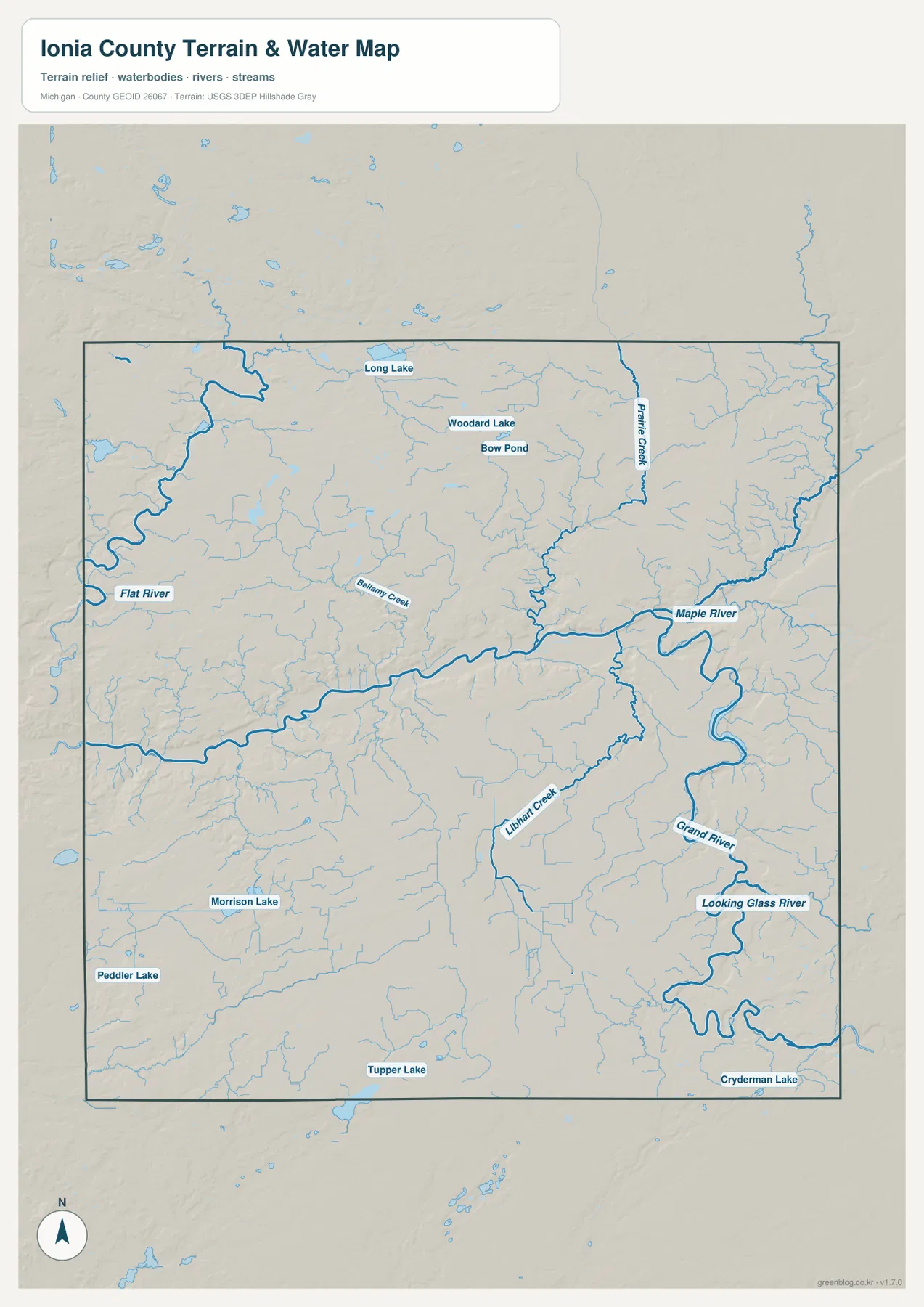
The terrain-and-water map is dominated by the Grand River. It crosses the central part of Ionia County and then bends through the east and southeast, creating a broad recognizable corridor. The Maple River approaches from the northeast and joins the larger system, while the Looking Glass River appears in the southeast. Together they make the eastern half of the county look much more intricate than the road map alone suggests. The map is especially helpful around Ionia, Lyons, and Portland, where town locations and major river bends can be compared directly.
Other named waterways fill in the picture. The Flat River runs near the western side and is a useful landmark for the Belding area. Bellamy Creek crosses the central-western part of the county toward the Grand River system. Prairie Creek is labeled in the northeast, and Libhart Creek appears farther south and east. Numerous smaller unnamed channels branch between these named streams. They create a fine network across the county rather than leaving large areas without visible drainage, which helps explain the repeated narrow valleys that appear later on the elevation map.
The map also labels several smaller lakes and ponds. Long Lake, Woodard Lake, and Bow Pond appear in the northern part of the county. Morrison Lake and Peddler Lake provide references in the southwest, Tupper Lake sits near the southern edge, and Cryderman Lake is shown in the southeast. These water bodies are not as important to countywide orientation as the Grand or Maple rivers, but they are valuable local markers. They can distinguish one rural area from another when the surrounding road pattern is sparse and many nearby streams look similar.
This water map is intended for geographic reference, not for flood determination, boating navigation, parcel boundaries, or public-access decisions. A stream shown on the image does not indicate current depth, bridge clearance, legal access, or flood probability. Those questions require the appropriate current agency data. At the county scale, the map has a simpler job: it shows where the major rivers, selected tributaries, and named lakes lie, and it makes their relationship to the county boundary much easier to see than a road-heavy map would.
An elevation range of about 188–290 meters makes the river valleys stand out
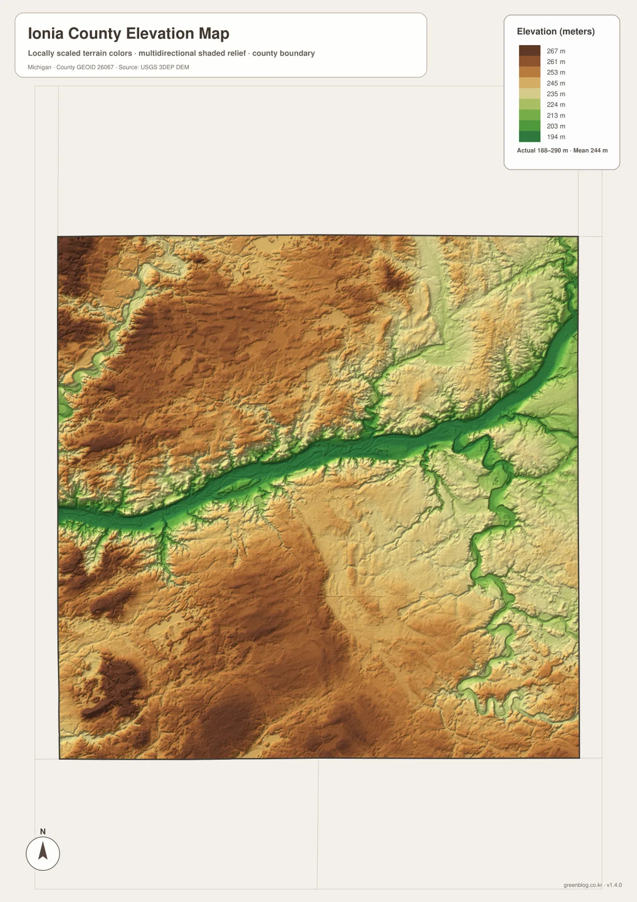
The elevation legend gives an actual mapped range of roughly 188 to 290 meters and a mean near 244 meters. Because the colors are locally scaled, green represents the lower parts of Ionia County while tan and brown represent progressively higher ground within the same county. The most obvious feature is a long green corridor across the middle and into the eastern side. Another green corridor bends southward in the east. When the elevation image is compared with the water map, those low areas line up closely with the Grand River and associated valleys.
Higher ground is broadest in several western and northwestern areas, with additional higher patches in the southwest. The difference is not mountainous, but the shaded relief makes the rolling terrain visible. Narrow green cuts extend into tan and brown ground where smaller tributaries occupy local valleys. This creates a textured surface that the general road map cannot show. Around the major river corridor, the transition from low green ground to higher surrounding terrain is especially clear, giving the central and eastern portions of the county a recognizable valley-and-upland pattern.
The 188- and 290-meter values should be understood as the displayed range for this generalized countywide surface, not as survey-grade elevations for individual parcels or structures. The image is appropriate for comparing broad relief, identifying lower river corridors, and explaining why neighboring parts of the county can look different. It should not replace a professional survey, engineering elevation model, or site-specific drainage study. For general geographic reference, its strength is exactly the opposite: it removes unnecessary detail so the main relief pattern can be seen at a glance.
Roads and rivers divide Ionia County into several practical reference areas
A useful way to remember the county is to connect each major community with the strongest nearby map feature. In the northwest, Belding pairs naturally with route 44 and the Flat River side of the county. The central area is defined by Ionia, routes 21 and 66, and the Grand River corridor. East of Ionia, Muir and Lyons lie along the same general east-west band but closer to the Maple River connection. In the southeast, Portland is tied to route 96 and a large bend of the Grand River. Lake Odessa provides a separate southern reference near route 50.
That framework also explains why no single map answers every question equally well. The overview is best when the task is to locate a town, road, county edge, or neighboring place. The city graphic simplifies the county to six ranked communities so their spacing can be compared quickly. The water image removes much of the road emphasis and brings the rivers, creeks, and lakes forward. The elevation view then strips the landscape down even further to relative height and shaded relief. Switching between them is more effective than trying to place every label and data layer on one crowded image.
Ionia and Portland illustrate that method clearly. Both are important county reference points, yet they occupy very different settings. Ionia sits near the central road crossing and the east-west river corridor. Portland is farther southeast, where route 96 and a prominent Grand River bend provide the stronger clues. Belding differs from both because its location is defined by the northwest corner, route 44, and the Flat River side. Once those three anchors are understood, Saranac, Lyons, and Lake Odessa are easier to place in relation to them.
Use the high-resolution JPG files when labels need more room
The embedded WebP images are sized for comfortable web viewing at 1273 × 1800 pixels. The downloadable originals are 2572 × 3638 pixel JPG files, providing more room for small place names, stream lines, and road labels when the map is enlarged or printed. The archive keeps the county overview, city distribution, terrain-and-water, and elevation views as separate files. That separation is useful for classroom handouts, presentations, reports, or personal reference because a reader can select only the layer needed for a particular explanation.
These maps remain county-scale references rather than turn-by-turn navigation or legal survey products. They do not show every street, parcel, bridge condition, drainage structure, or current road closure. The water graphic is not a flood map, and the elevation graphic is not an engineering surface. For orientation, however, the simplified design is useful: it keeps Ionia, Belding, Portland, the main numbered routes, named rivers, and broad relief readable without forcing all of that information into a single overloaded image.
Frequently Asked Questions
Which map is easiest for comparing Ionia and Portland?
Start with the county overview. Ionia appears near the center where routes 21 and 66 meet, while Portland is farther southeast along route 96 and close to a large bend of the Grand River. The city-distribution map is useful as a second view because it removes many smaller labels and makes the spacing between the two communities more obvious.
Why does the Grand River corridor appear green on the elevation map?
Green represents the lower parts of the locally scaled elevation surface. The Grand River and its associated valleys sit below much of the surrounding rolling ground, so a green band follows the central and eastern river corridor. Comparing the elevation view with the water map makes the match much clearer, especially where the Maple River and other tributaries approach the larger system.
What files are included in the Ionia County map download?
The ZIP contains four high-resolution JPG files: the county overview, ranked city-distribution map, terrain-and-water map, and elevation map. Each JPG is 2572 × 3638 pixels. They are suitable for printing and enlargement, but the water map should not be used as a flood or navigation product and the elevation image should not replace survey-grade or engineering measurements.
Map File Information
Download the map files associated with this page for reference, printing, and compatible visual projects.
- Included Files: Use only the versions confirmed in the article and supplied images
- File Type: Use the confirmed download contents
- Intended Use: Printing, education, presentations, and map-based projects
Related Maps
Sources and references
For current county information and the public datasets commonly used to check boundaries, waterways, and elevation, the following sources provide useful follow-up material. These edited maps are intended for broad geographic reference, so legal, engineering, flood, or site-specific questions should be checked against the appropriate official product.
- Ionia County – About Ionia County – official county overview and regional context
- U.S. Census Bureau QuickFacts: Ionia County, Michigan – current demographic and county statistics
- U.S. Census Bureau TIGER/Line Shapefiles – county boundaries and geographic data
- USGS National Hydrography – rivers, streams, and surface-water data
- USGS 3D Elevation Program – elevation data
Green Map creates custom-edited map images using open geographic data sources such as geoBoundaries, Natural Earth, OpenStreetMap, and government open data. These maps are edited visual materials, not raw data files, and are provided for education, documents, presentations, and graphic reference.