Chippewa County spans the eastern end of Michigan’s Upper Peninsula, from high forested ground along the western interior to Sault Ste. Marie and the St. Marys River in the northeast, then south toward De Tour Village and Drummond Island. The county is unusual because its geography is split between broad inland terrain and a long international water corridor filled with bays, channels, and islands. Sault Ste. Marie is the major riverfront city, while De Tour Village marks the southeastern mainland near the approach to Drummond Island.
This page uses the supplied county, city-distribution, terrain-and-water, and elevation maps to explain those differences without treating every part of the county as the same landscape. High-resolution JPG originals are available in a ZIP download for printing, classroom work, presentations, and detailed reference. The most useful contrast is between the elevated western M-28 interior and the much lower St. Marys River and southeastern coastal side.
M-28 crosses the sparsely settled western mainland, I-75 leads directly into Sault Ste. Marie, and M-129 helps connect the central county with the northeast. Farther southeast, M-48 and M-134 lead toward De Tour Village, where the mainland road system ends at a complex shoreline. Drummond Island continues the county eastward beyond that road network.
Table of Contents
M-28 interior roads give way to the Sault Ste. Marie and De Tour corridors
Sault Ste. Marie contains the densest road pattern on the general county map. I-75 reaches the city from the south, while M-129 and local roads connect surrounding inland areas with the riverfront urban zone. Because the St. Marys River forms the eastern edge, the road network is compressed onto the land side of the river rather than spreading evenly in all directions.
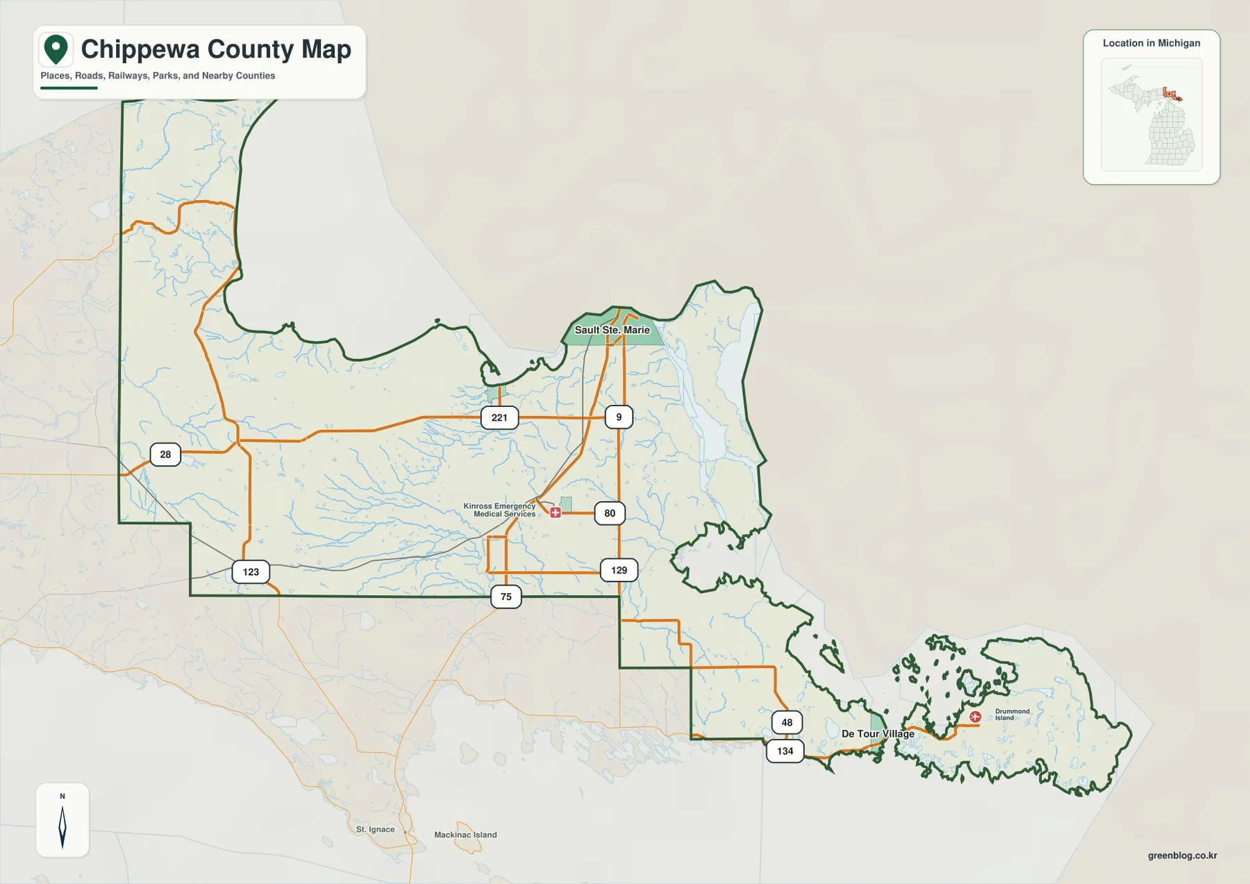
M-28 is the key road across the western and central interior. Long stretches pass through forested country with few settlement labels, while M-123 and M-221 serve smaller northern areas. The gaps between major roads are much larger than around Sault Ste. Marie, reflecting a landscape where rivers, wetlands, and uplands occupy more space than urban development.
Near Kinross, I-75, M-80, and M-129 create a more connected central road pattern. This area sits between the western interior and the St. Marys River side, making it a practical transition point on the map. From here, northbound travel leads toward Sault Ste. Marie, while southeastern routes continue through lower terrain toward M-48 and M-134.
M-134 reaches De Tour Village near the southeastern mainland edge. Drummond Island lies just offshore, so the county continues beyond the end of the mainland road network. The map is useful for regional orientation, but current winter closures, construction, and island transportation schedules need to be checked with live travel information.
Two highlighted settlements show the reach of the eastern shoreline
The city-distribution map highlights only Sault Ste. Marie and De Tour Village. Sault Ste. Marie sits beside the St. Marys River in the northeast, while De Tour Village is near the far southeastern mainland edge. There is no connector line or distance measurement on this map, so it should be used to compare relative positions rather than road or straight-line distance.
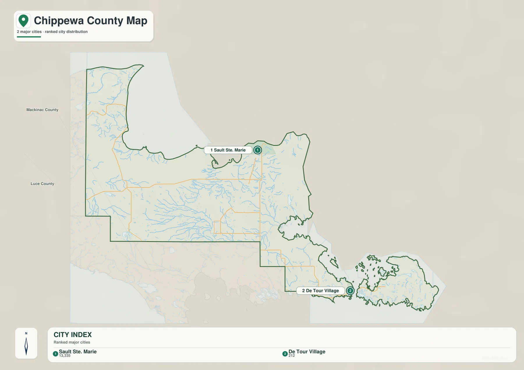
The CITY INDEX shows reference values of 13,335 for Sault Ste. Marie and 212 for De Tour Village. These values are ranking inputs for the map, not a claim about the latest official population. Current estimates should be checked in the appropriate U.S. Census Bureau release when up-to-date population figures are needed.
Sault Ste. Marie is the clear urban center in both the general and city maps. I-75 and local roads converge there, and the St. Marys River runs directly along the city’s eastern side. The elevation view also shows a broad low river corridor, reinforcing the close relationship between the city and the waterway.
De Tour Village has a much smaller road footprint, but its location becomes more meaningful when the water map is added. Channels, islands, and the approach to Drummond Island dominate the southeastern geography. Kinross and other inland places appear on the general map but are not part of this two-place ranking.
The St. Marys River corridor meets long interior drainage systems
The St. Marys River is the defining water feature along the eastern side of the county. It runs past Sault Ste. Marie and continues south through broad channels and island groups toward Lake Huron. Around De Tour Village and Drummond Island, the shoreline becomes especially intricate, making the county boundary as much a water geography as a land boundary.
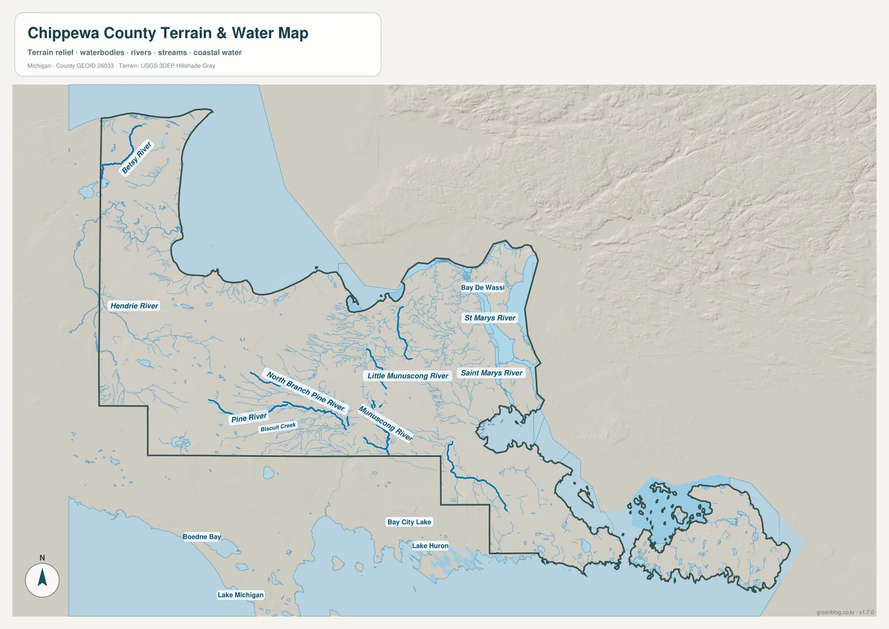
Munuscong River and Little Munuscong River drain the east-central mainland toward the lower St. Marys River side. Numerous small tributaries spread through low terrain, and the surrounding relief map shows broad green areas rather than the higher brown uplands of the west. The river network helps explain why the central-east landscape appears flatter and wetter.
Pine River and North Branch Pine River extend across the central and southwestern interior. Tributaries such as Biscuit Creek join them as they move through forested country toward lower ground. Instead of one dominant inland lake, much of Chippewa County is organized by long branching rivers and wet corridors.
Betsy River and Hendrie River cross the western interior, where the relief is much stronger. Their valleys cut lower paths between ridges and provide geographic reference points even in areas with few towns or major roads. This map is not a navigation or flood product, so water depth, channel suitability, legal access, and flood risk require current official sources.
Western ridges stand above the St. Marys River and island lowlands
The elevation legend reports an actual county range of about 173 to 327 meters, with a mean of 218 meters. Dark green marks the lower parts of the county, lighter green and yellow show intermediate ground, and brown identifies the higher uplands. The color scale is local to this county and should be used for relative comparison within Chippewa County rather than against another county map.
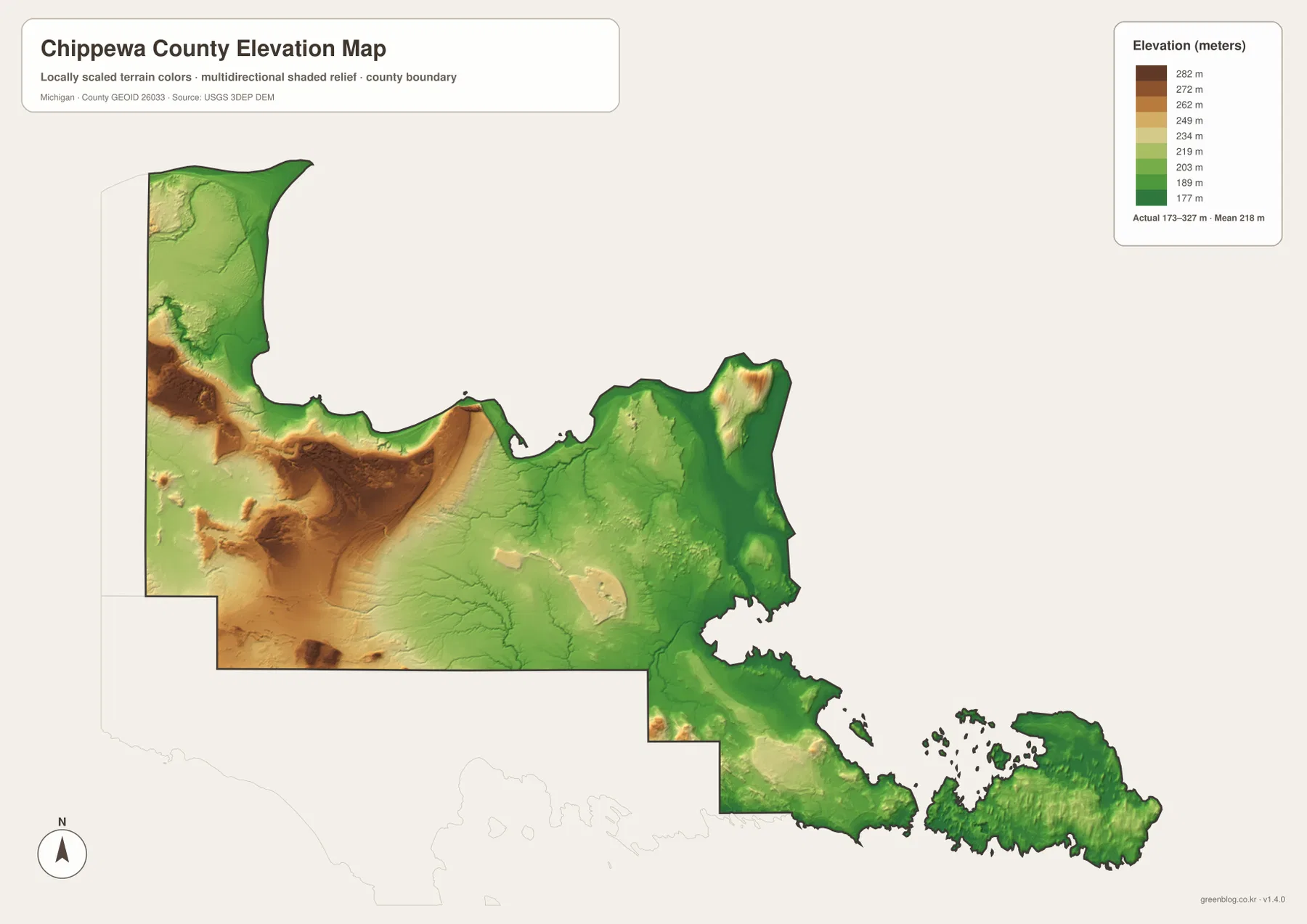
The strongest brown terrain is concentrated in the west and northwest near the Luce County side. River valleys cut green channels through these uplands, creating a repeated ridge-and-valley pattern around the M-28 interior. The western road map and elevation surface together show why this part of the county feels very different from the riverfront east.
Central Chippewa County is more moderate in elevation. Pine River, Munuscong River, and smaller drainage lines occupy lower corridors through light-green and yellow terrain. Moving eastward, the broad western uplands become less dominant and low wet areas become more widespread.
Sault Ste. Marie and the St. Marys River side are among the lowest broad areas on the map. De Tour Village and Drummond Island also remain mostly green or light green, with only modest local rises. The elevation surface is a county-scale reference rather than survey-grade data, so engineering, construction, and parcel-level work requires authoritative detailed elevation sources.
Four parts of the county explain its geographic range
The western M-28 interior is defined by long forested distances, sparse settlement, and higher relief. Betsy, Hendrie, and Pine river systems cut through the uplands, while major roads remain widely spaced. It is the part of the county least similar to the Sault Ste. Marie riverfront.
The Kinross area forms a practical transition zone. I-75, M-80, and M-129 provide clearer road connections than farther west, while small streams continue east toward lower St. Marys River terrain. Elevation is more moderate, and the landscape begins to flatten compared with the western ridges.
Sault Ste. Marie combines the county’s strongest urban road pattern with one of its largest low river corridors. The St. Marys River defines the eastern edge of the city, and I-75 gives the urban area a direct north-south connection. The relationship between road density, low relief, and river access is especially clear when the general, water, and elevation maps are compared.
De Tour Village and Drummond Island represent the coastal and island end of the county. M-134 reaches the mainland shore, then channels and islands take over as the dominant geographic features. This southeastern lowland is a sharp contrast with the western interior, and the difference is visible even before individual place labels are added.
For road and place reference, the general county map is the most complete option. The city map is useful for the two highlighted settlements, the water map explains the St. Marys River and interior drainage, and the elevation map shows the west-to-east relief contrast. The downloadable ZIP below contains the original high-resolution JPG versions for larger displays and print use.
Frequently Asked Questions
Which map is best for comparing Sault Ste. Marie with De Tour Village and Drummond Island?
Use the general county map for roads, named places, and the position of Drummond Island relative to the mainland. Add the terrain-and-water map when the St. Marys River channels, shoreline, and island geography matter more than the road network.
How do the western rivers differ from the St. Marys River side?
Betsy, Hendrie, and Pine river systems cut through higher western terrain, while Munuscong River and the St. Marys River side occupy broader lowlands in the east. Comparing the water and elevation maps makes that contrast much clearer.
Where is the highest terrain in Chippewa County?
The highest broad uplands are concentrated in the west and northwest, while Sault Ste. Marie, the St. Marys River corridor, De Tour Village, and Drummond Island are generally lower. The legend shows a county range of roughly 173 to 327 meters, but exact site elevations should be checked in authoritative elevation data.
Map File Information
The ZIP contains the high-resolution JPG originals for the Chippewa County general map, city-distribution map, terrain-and-water map, and elevation map.
- Included Files: general county map, city-distribution map, terrain-and-water map, elevation map
- File Type: JPG
Related Maps
Sources and reference links
For county government and local information, see the official Chippewa County website. For boundary and road-reference data, consult U.S. Census Bureau TIGER/Line. Water features can be cross-checked with USGS National Hydrography, and elevation data with the USGS 3D Elevation Program. These maps are general reference products and do not replace legal boundaries, surveys, navigation charts, or flood determinations.
Green Map creates custom-edited map images using open geographic data sources such as geoBoundaries, Natural Earth, OpenStreetMap, and government open data. These maps are edited visual materials, not raw data files, and are provided for education, documents, presentations, and graphic reference.