Hancock County stretches from a broad inland section of eastern Maine to one of the state’s most intricate coastal landscapes. Ellsworth is the easiest starting point on the map because several important roads meet there before continuing toward Bucksport, Blue Hill, Mount Desert Island, Bar Harbor, and the Schoodic side of the coast. This page compares county roads and boundaries, the city index, and the river-and-coast map, and the same high-resolution maps can be downloaded as JPG files in one ZIP archive. High-resolution map files are available for download in the section below.
The county changes character sharply from north to south. Inland, the boundary encloses a long expanse filled with lakes, streams, and relatively sparse settlement labels. Farther south, the outline breaks into peninsulas, islands, harbors, and narrow passages around Blue Hill Peninsula, Mount Desert Island, Deer Isle, and the open Atlantic. Looking at the three maps together makes it easier to understand why a place that appears compact on a statewide inset becomes geographically complex at the coast.
Table of Contents
Ellsworth as the Road Gateway to a Deeply Indented Coast
Ellsworth stands out on the county map as the main road junction in the southern mainland. Route 1A and Route 3 approach from the west, while U.S. 1 and several state routes continue east and south through the county. Hancock County’s official website places county government offices and the courthouse in Ellsworth as well, so the map’s visual emphasis matches its administrative role. Starting here gives the reader a practical reference point before tracing roads toward the islands and peninsulas.
Route 3 is especially useful for understanding the connection between Ellsworth and Mount Desert Island. The National Park Service directs visitors bound for the Mount Desert Island section of Acadia National Park through Ellsworth and then along Route 3. On the county map, Bar Harbor sits on the eastern side of the island while Southwest Harbor lies farther around the southwestern shore. The coastline between them is anything but straight, so the road network has to follow the shape of the island rather than a simple north-south line.
West of Ellsworth, Bucksport occupies a position near the Penobscot River side of the county. Farther south, Castine sits on a projecting coastal area, while Blue Hill lies inland from the surrounding bays and peninsulas. Routes 15, 172, 175, and 176 help orient this southwestern portion of Hancock County. The roads are useful not only as transportation references but also as a way to separate settlements that may look close on a small statewide map yet are divided by long inlets and irregular shorelines.
The eastern coast has a different pattern. U.S. 1 continues east of Ellsworth and connects with Route 186, which leads toward Winter Harbor and the Schoodic Peninsula. The National Park Service gives the same general approach for the Schoodic section of Acadia: travel east from Ellsworth on U.S. 1 and then turn onto Route 186. This helps distinguish Winter Harbor from Bar Harbor. They are both associated with the Acadia coast, but they sit on separate landforms with water between them.
The county boundary continues much farther north than the better-known coastal places might suggest. Route 9 crosses the upper part of the mapped road network, Route 193 appears toward the northeast, and Routes 180, 179, 182, and 200 connect areas north and east of Ellsworth. Settlement names are less dense here, but lakes and streams remain abundant. The statewide locator reinforces this shape: Hancock County occupies part of Maine’s eastern coast and then extends a considerable distance inland.
Neighboring county labels provide additional orientation. Penobscot County is to the north and northwest, Washington County to the east, and Waldo, Piscataquis, and Knox counties appear around the western side of the map. Hancock County’s own boundary-history page lists Ellsworth along with towns such as Bar Harbor, Blue Hill, Bucksport, Castine, Deer Isle, Mount Desert, Southwest Harbor, Stonington, and Winter Harbor. That list helps explain why the southern boundary has so many separate island and shoreline pieces instead of one smooth edge.
What the Single-City Index Says—and What It Does Not
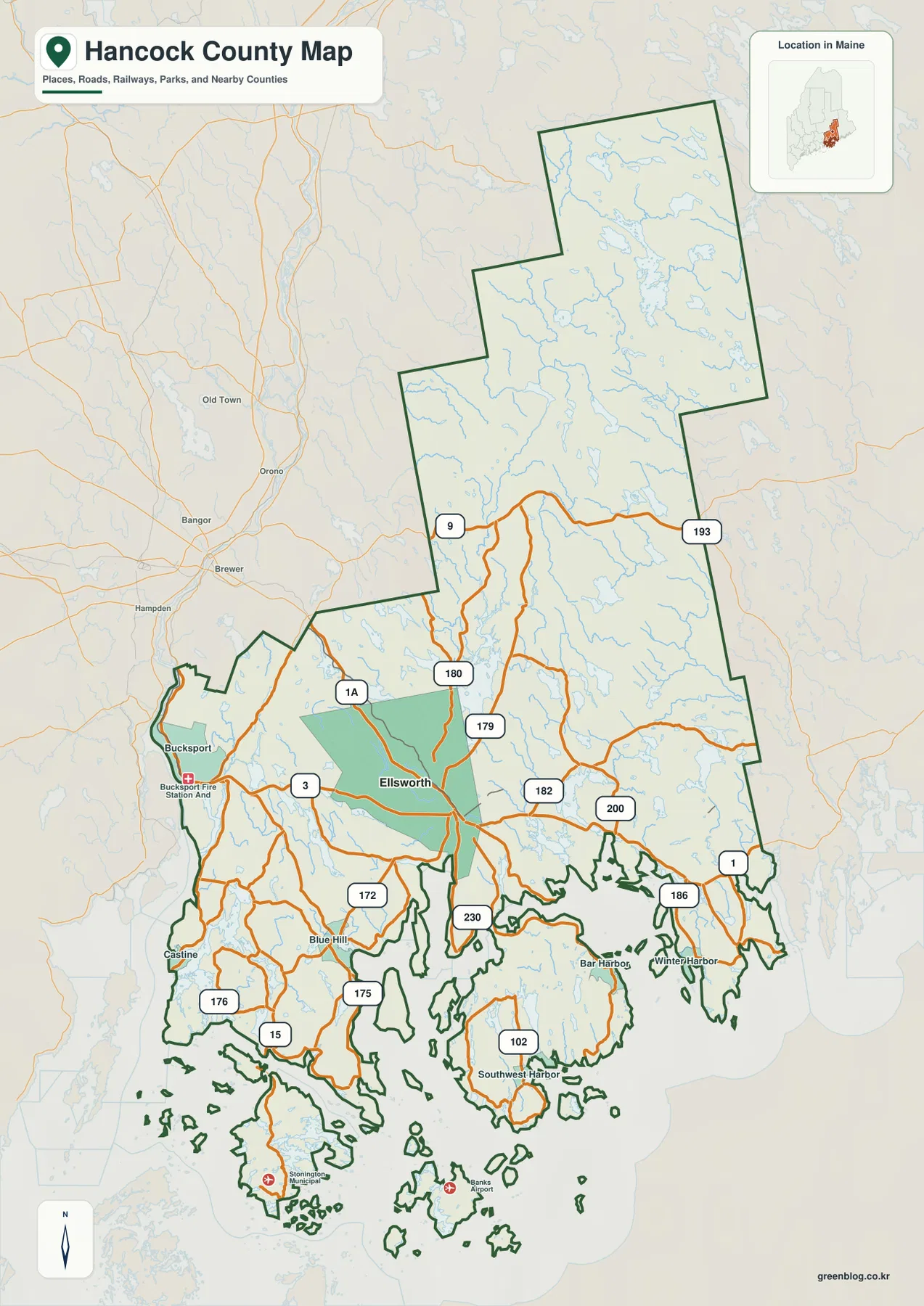
The city-index map is unusually simple: Ellsworth is the only ranked major city shown. That does not mean the rest of Hancock County lacks important communities. Bar Harbor, Bucksport, Blue Hill, Castine, Southwest Harbor, Winter Harbor, and many other places are visible on the broader county map, but they do not all share the same municipal classification. The index should therefore be read as a compact city-focused graphic rather than a ranking of every significant settlement in the county.
Ellsworth is positioned in the southern mainland rather than at the outer coast. This location becomes more meaningful when compared with the road map. Route 1A and Route 3 arrive from the west, U.S. 1 continues east, and Route 3 also provides the familiar approach toward Mount Desert Island. Ellsworth therefore works as a bridge between inland Hancock County and the coastal destinations that spread south and east from the city.
A numeric index value appears beside Ellsworth in the supplied graphic, but the map package does not establish the reference year or statistical definition for that number. For that reason, this article does not treat it as a current population estimate. Anyone who needs up-to-date population totals should check a current Census Bureau product. Here, the useful information is the city’s mapped location and its relationship to the much larger county boundary.
The city map also makes the county’s north-south scale easier to notice. Ellsworth sits well below the middle of the boundary, while the county continues far to the north with very few large settlement labels. Penobscot, Washington, Waldo, Piscataquis, and Knox counties are named outside the boundary, providing regional context without cluttering the interior. The apparent emptiness in the north should not be mistaken for an absence of geographic features; the water map shows just how dense the lake and stream network is there.
For a presentation that needs one clear reference city, the index graphic is efficient. For a lesson or regional comparison that needs Bar Harbor, Bucksport, Blue Hill, Castine, or the island communities, the full county map is the better choice. Using the two together lets the reader understand why Ellsworth functions as a central reference point without reducing Hancock County to a single urban place.
Union River Branches, Narraguagus River, Bays, and Islands
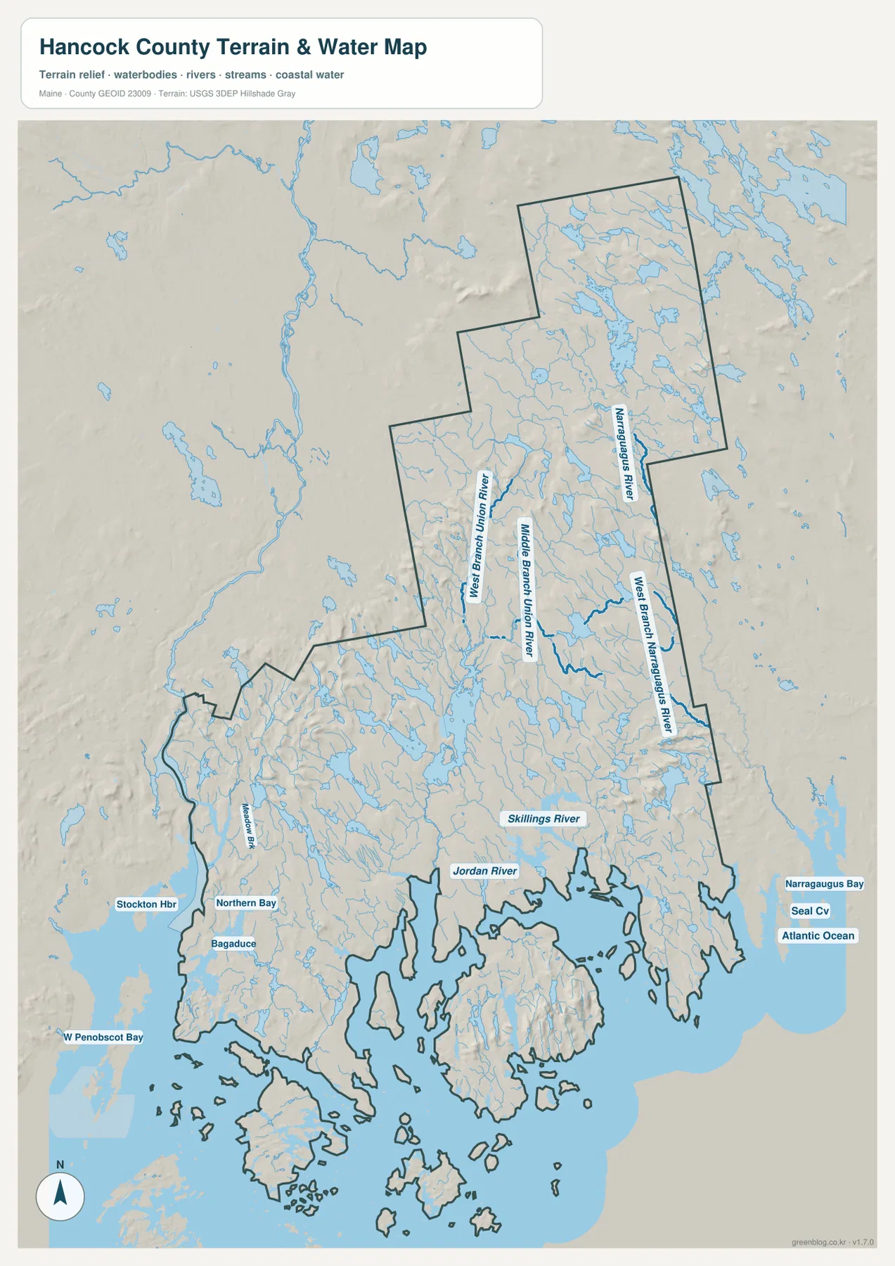
The terrain-and-water map changes the emphasis from roads to drainage and coastline. North of Ellsworth, the West Branch Union River and Middle Branch Union River are labeled among a dense pattern of lakes and tributaries. These branches show that the broad inland section is strongly shaped by water even where few settlement names appear. Following the drainage southward helps connect the inland landscape with the lower river and coastal waters around Ellsworth.
On the eastern side of Hancock County, the Narraguagus River and West Branch Narraguagus River form another prominent system. They run through a different part of the county from the Union River branches and give the northeastern area its own geographic reference. Farther south and east, Narraguagus Bay opens toward the Atlantic. Reading the river labels together with the bay makes it clear that eastern Hancock County is not simply an extension of the Ellsworth-Mount Desert coast.
Closer to the middle coast, Skillings River and Jordan River are labeled near a maze of coves, inlets, and projecting land. These are smaller coastal rivers, but they are useful landmarks because they sit where the mainland begins to fragment into narrow peninsulas and island-dotted water. The map is especially helpful here: a road-only view can make the land seem dominant, while the water layer reveals how much of the county’s southern geography is defined by tidal shoreline.
The southwestern coast carries another group of names. Stockton Harbor, Northern Bay, and Bagaduce appear near the Blue Hill and Castine side, with West Penobscot Bay beyond. South of this area, Deer Isle, Stonington, and numerous smaller islands occupy a broken coastal zone. After locating Castine and Blue Hill on the road map, these water labels make the shape of the peninsulas much easier to understand.
To the east, Narraguagus Bay, Seal Cove, and the Atlantic Ocean mark the outer coast beyond the Winter Harbor and Schoodic area. Between the western Penobscot Bay waters and the eastern Narraguagus side lie Mount Desert Island, multiple peninsulas, and many offshore islands. That variety is one of the most distinctive features of Hancock County. The county is not organized around a single river mouth or one continuous shoreline; instead, several drainage systems meet a coast divided into many separate basins and channels.
Shaded relief in the background adds broad terrain context. Inland areas contain rolling, irregular ground around the lakes, while Mount Desert Island and several peninsulas also show stronger relief than low coastal flats. The shading is useful for seeing general changes in landform, but it is not survey-grade elevation. It should not be used to measure a precise slope, site elevation, or engineering constraint.
The same caution applies to the water layer. It is a general reference map of rivers, streams, lakes, bays, coastal water, and terrain. It does not provide flood probabilities, live water levels, depth soundings, tides, navigation marks, or legal water boundaries. Boating, flood planning, emergency response, and property decisions require current information from agencies such as USGS, NOAA, FEMA, the State of Maine, or the relevant local authority.
Separating Mount Desert Island, Blue Hill Peninsula, and Schoodic
A common challenge when reading Hancock County at small scale is that many famous coastal places appear close together. The county map shows that Bar Harbor is on Mount Desert Island, while Blue Hill is on the mainland side of a separate peninsula. From Ellsworth, Route 3 leads toward Mount Desert Island; roads such as Route 172 lead toward the Blue Hill area instead. Water between the peninsulas and islands means that short straight-line separations do not necessarily translate into equally short driving routes.
Southwest Harbor provides another useful example. It lies on the southwestern side of Mount Desert Island, not on the mainland opposite Blue Hill. Route 102 is one of the island roads visible on the map, while Route 3 approaches the island from the Ellsworth side. Looking at the water map after the road map helps explain why the island’s communities face different bays and channels even though they share the same landmass.
Blue Hill, Castine, and the Deer Isle-Stonington direction belong to the western side of the county’s coastal pattern. Route 15 reaches toward the islands, while Routes 175 and 176 help trace mainland communities around the bays. Stockton Harbor, Northern Bay, and Bagaduce on the water map provide additional landmarks. Together these features make the southwestern coast easier to distinguish from the Mount Desert Island area farther east.
Winter Harbor and the Schoodic area sit east of Mount Desert Island across separate coastal water. U.S. 1 and Route 186 provide the clearer mainland approach from Ellsworth. The National Park Service also treats Schoodic Peninsula as a separate approach from the Mount Desert Island side of Acadia. That distinction is useful for interpreting the county map: two destinations can both be associated with the same national park region while still occupying different peninsulas and requiring different road routes.
Choosing the Right Hancock County Map for the Task
Use the county road map when the main question is where towns and routes sit in relation to one another. Begin with Ellsworth, then follow Route 3 toward Bar Harbor, U.S. 1 toward the Winter Harbor side, or the western roads toward Bucksport, Blue Hill, and Castine. Because the county outline includes many islands, this map is also useful for recognizing which pieces of land belong to Hancock County rather than a neighboring coastal county.
Use the city index when the purpose is narrower: showing Ellsworth as the county’s ranked major city and locating it inside the full county shape. The graphic deliberately removes many settlement labels, so it should not be treated as a complete community map. Its strength is simplicity. A reader can immediately see that Ellsworth lies in the southern mainland while much of Hancock County extends northward beyond it.
Use the terrain-and-water map when rivers, bays, islands, or broad landform differences matter most. The West and Middle branches of the Union River help organize the inland side, the Narraguagus system defines much of the east, and Penobscot Bay waters contrast with Narraguagus Bay and the Atlantic coast. It is also the clearest of the three graphics for explaining why southern Hancock County has such an irregular outline.
The WebP images embedded in the article are optimized for on-screen viewing. The downloadable archive contains the corresponding three high-resolution JPG originals, each measuring 2572 × 3638 pixels. For a printed handout, a useful sequence is to begin with the county road map, use the city index to emphasize Ellsworth, and finish with the water-and-terrain map to explain the rivers, bays, islands, and coastal shape.
All three maps are general geographic references. They are not substitutes for legal boundary surveys, parcel records, live traffic data, flood studies, navigation charts, or engineering-grade elevation measurements. Hancock County’s complicated coast makes that limitation particularly important: a simplified map can provide orientation, but decisions involving safety, ownership, travel restrictions, or precise measurements should be checked against current authoritative sources.
Frequently Asked Questions
How are Ellsworth and Bar Harbor connected on the Hancock County map?
Ellsworth is on the southern mainland, while Bar Harbor is southeast of it on Mount Desert Island. Route 3 provides the clearest mapped connection from Ellsworth toward the island and Bar Harbor. For an actual trip, use current road and traffic information because travel time can change with construction, seasonal congestion, and local conditions.
Why does the City Index show only Ellsworth?
The City Index is a ranked-major-city graphic, not a complete list of every important community. Hancock County contains many well-known towns and island communities, including Bar Harbor, Bucksport, Blue Hill, Castine, Southwest Harbor, and Winter Harbor, but they are better viewed on the full county map. The index is most useful for highlighting Ellsworth’s position inside the county.
Can the terrain and water map be used for flood or boating decisions?
No. It shows the general locations of rivers, lakes, bays, coastal water, and terrain relief, but it does not include flood probability, current water levels, tides, depth soundings, channels, or navigation aids. Flood planning and boating decisions should rely on current official information from agencies such as USGS, NOAA, FEMA, the State of Maine, and local authorities.
Map File Information
Download the three high-resolution Hancock County JPG maps described on this page in one ZIP archive.
- Included Files: county and road map, city index map, terrain and water map
- Printable Size: 2572 × 3638 pixels each
- File Type: JPG
Related Maps
Sources and References
- Hancock County, Maine – Official County Website
- Hancock County, Maine – County Boundaries
- U.S. National Park Service – Acadia National Park Basic Information
- U.S. Census Bureau – TIGER/Line Shapefiles
- USGS – National Hydrography
Green Map creates custom-edited map images using open geographic data sources such as geoBoundaries, Natural Earth, OpenStreetMap, and government open data. These maps are edited visual materials, not raw data files, and are provided for education, documents, presentations, and graphic reference.