Whitley County lies in southeastern Kentucky, where Corbin and Williamsburg anchor the main road network and the Appalachian terrain becomes more rugged toward the south and east. This Whitley County Kentucky Map collection shows Corbin, Williamsburg, Rockholds, I-75, US 25W, KY 92, KY 11, the Laurel River drainage, and elevations ranging from about 213 to 671 meters.
The web previews provide quick reference, and a downloadable ZIP contains the four original high-resolution JPG maps. The road, city, water, and elevation files make it easier to compare the I-75 corridor with the narrow mountain valleys and high ridges away from the main north–south route.
Table of Contents
I-75 links Corbin and Williamsburg through the main north–south corridor
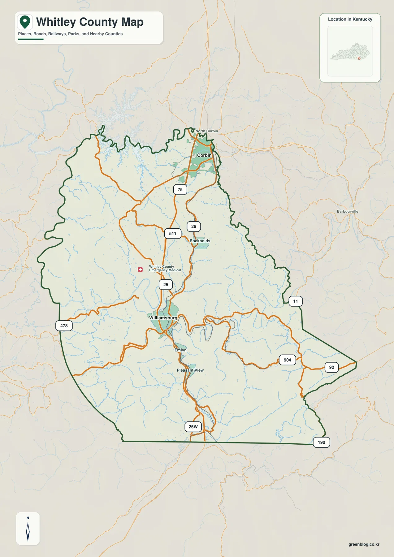
I-75 is the clearest transportation feature on the general map. It enters near Corbin in the north, passes west of Rockholds, and continues south to Williamsburg. Below Williamsburg, US 25W carries the same north–south pattern toward Tennessee. Those two routes provide the simplest framework for reading the rest of the county.
Corbin has the densest road pattern in the north, with North Corbin nearby and KY 26 connecting the local network. From Williamsburg, KY 92 runs east across the mountain country, while KY 904 and KY 11 provide additional routes through the eastern side. KY 478 reaches toward the west, and KY 190 appears near the southeastern edge.
Emlyn and Pleasant View are labeled south of Williamsburg. Roads become increasingly winding away from the I-75 corridor because narrow valleys and high ridges leave fewer direct routes. The county map is intended for geographic orientation rather than current traffic, construction, speed limits, or private access conditions.
Corbin and Williamsburg provide two clear city anchors
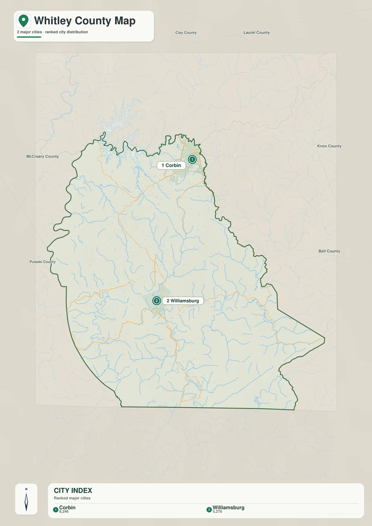
The city map removes most route detail and highlights Corbin and Williamsburg. Corbin sits close to the northern boundary, while Williamsburg lies farther south. Their alignment along I-75 makes the county’s basic north–south organization easy to understand.
Clay and Laurel Counties are labeled to the north, Knox and Bell Counties to the east, and McCreary and Pulaski Counties to the west. The southern boundary reaches Tennessee. The figures printed in the city index belong to the map’s source snapshot and should not be treated as current official population counts.
Laurel River and a dense creek network fill the mountain valleys
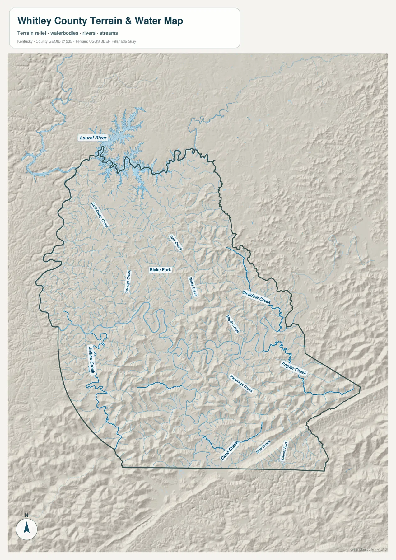
The Laurel River is the largest named water feature on the northern side. Its broad bends stand out near the northwest, with Bark Camp Creek and many shorter tributaries entering the surrounding hills. Youngs Creek, Carr Creek, Blake Fork, and Watts Creek help organize the central drainage.
Farther east, Meadow Creek and Maple Creek occupy long narrow valleys. Poplar Creek and Patterson Creek are prominent in the southeast, while Jellico Creek forms a strong southwestern reference. Cane Creek, Mud Creek, and Laurel Fork appear near the southern edge. Together, these waterways show how thoroughly the uplands are divided by valleys.
This file is a geographic water reference, not a flood map, navigation chart, depth map, parcel survey, or legal shoreline record. Flood risk, water depth, access, and regulatory questions require current specialized agency data.
Elevation from 213 to 671 meters rises sharply into the southern and eastern ridges
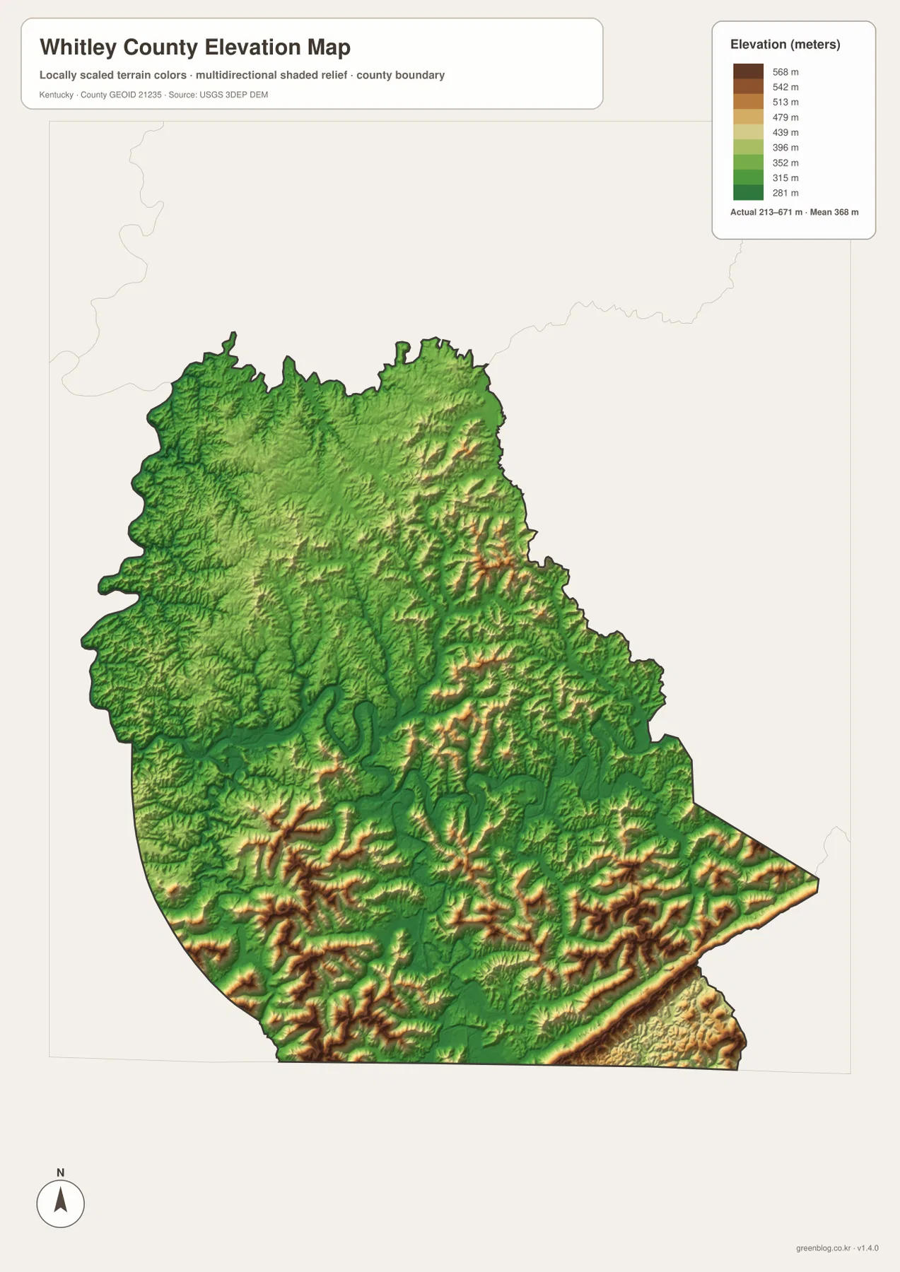
The elevation legend reports an actual county range of about 213 to 671 meters, with a mean near 368 meters. Green represents lower ground, while yellow, orange, and brown mark progressively higher terrain. The lower colors follow stream corridors through the north and center, while warmer colors increase rapidly toward the south and east.
The southeastern and southern edges contain some of the most continuous high ridges on the map. Poplar Creek, Patterson Creek, Cane Creek, and other streams occupy narrow green valleys between them. Corbin and the northern side lie in generally lower terrain, while Williamsburg sits among valley floors and surrounding uplands.
The 213–671 meter range is useful for county-scale comparison, not survey or engineering work. Construction grades, bridge elevations, drainage calculations, and parcel-level measurements require higher-resolution USGS data and, where necessary, professional field surveying.
Following Corbin to Williamsburg reveals the county’s strongest terrain transition
Starting at Corbin and following I-75 toward Williamsburg is the easiest way to compare the map layers. The road map emphasizes the highway and communities, the water map adds an increasing number of mountain creeks, and the elevation file shows the transition from lower northern valleys into higher southern ridges.
East from Williamsburg along KY 92 and KY 904, Meadow Creek, Maple Creek, Poplar Creek, and other streams become stronger references. South toward US 25W and KY 190, Jellico Creek and Cane Creek help organize another series of narrow valleys approaching Tennessee.
Choose the Whitley County file that matches the detail you need
The general county map is the best starting point for Corbin, Williamsburg, numbered roads, and the county outline. The city map is cleaner when only the two major city references matter. The terrain-and-water file is strongest for Laurel River and the creek network, while the elevation map makes the 213–671 meter relief easiest to compare.
- County map: Use it for Corbin, Rockholds, Williamsburg, Emlyn, Pleasant View, I-75, US 25W, KY 26, KY 92, KY 11, KY 190, KY 478, and KY 904.
- City map: Use it to compare Corbin and Williamsburg and the directions of Clay, Laurel, Knox, Bell, McCreary, and Pulaski Counties.
- Terrain and water map: Use it for Laurel River, Bark Camp Creek, Blake Fork, Meadow Creek, Poplar Creek, Jellico Creek, Cane Creek, and other tributaries.
- Elevation map: Use it to compare the approximately 213–671 meter relief, especially lower northern valleys and the high southern and eastern ridges.
Each original JPG measures 2572 × 3638 pixels in portrait orientation, preserving more small road and creek labels than the web previews. Keeping the original aspect ratio is recommended for printing.
Frequently Asked Questions
Which map is best for Corbin, Williamsburg, and I-75?
The general county map is the best choice because it combines Corbin, Rockholds, Williamsburg, I-75, US 25W, KY 26, KY 92, KY 11, KY 190, KY 478, and KY 904 in one view.
Where can I see Laurel River and Poplar Creek most clearly?
The terrain-and-water map shows Laurel River, Bark Camp Creek, Blake Fork, Meadow Creek, Poplar Creek, Patterson Creek, Jellico Creek, Cane Creek, and many smaller tributaries. It is a geographic reference rather than a flood, depth, navigation, or legal-boundary map.
What stands out most on the 213–671 meter elevation map?
The north and central stream corridors are relatively low, while the south and east contain closely spaced high ridges separated by narrow valleys. The county mean is about 368 meters, but the map is intended for regional comparison rather than construction or survey measurements.
Map File Information
The ZIP contains high-resolution JPG versions of the Whitley County general map, city map, terrain-and-water map, and elevation map. Use the previews to check Corbin, Williamsburg, the I-75 corridor, Laurel River tributaries, and the 213–671 meter relief before opening the original files.
- Included Files: Use only the versions confirmed in the article and supplied images
- File Type: Use the confirmed download contents
- Intended Use: Printing, education, presentations, and map-based projects
Related Maps
Sources and references
The geographic discussion is based primarily on the supplied Whitley County maps, with official county, city, boundary, hydrography, and elevation sources used for context.
- Whitley County Fiscal Court — official county government information.
- City of Corbin official website — official city information and services.
- U.S. Census Bureau TIGER/Line Shapefiles — official geographic boundary and road data.
- USGS National Hydrography — federal hydrography background for rivers, creeks, and water features.
- USGS 3D Elevation Program — federal elevation and terrain data program.
Green Map creates custom-edited map images using open geographic data sources such as geoBoundaries, Natural Earth, OpenStreetMap, and government open data. These maps are edited visual materials, not raw data files, and are provided for education, documents, presentations, and graphic reference.