Webster County stretches across part of western Kentucky, with Providence, Dixon, Sebree, Clay, Slaughters, and Wheatcroft spread across a landscape of short ridges, shallow creek valleys, and rural road corridors. This Webster County Kentucky Map collection shows those communities with US 41A, KY 56, KY 120, KY 132, KY 283, the Deer Creek drainage, and terrain ranging from about 103 to 196 meters.
Visitors can review the web previews first and then download a ZIP containing the four original high-resolution JPG maps. Kentucky’s state profile places Webster County in the Western Coal Field region, and the map set reflects that rolling western-Kentucky setting: the central and western interior contains many short ridges, while broad low areas appear toward the east and southwest.
Table of Contents
Providence, Dixon, and Sebree organize the main road view
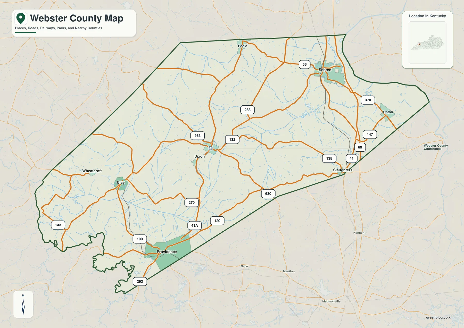
Providence, Dixon, and Sebree provide three convenient reference points. Providence sits in the south, Dixon is close to the middle of the county, and Sebree lies in the northeast. US 41A and KY 109, KY 120, and KY 293 serve the Providence side. Around Dixon, KY 132, KY 983, KY 270, and KY 283 connect in several directions, while Sebree is tied to KY 56 and KY 370.
Clay and Wheatcroft form another cluster on the western side. KY 109 and KY 143 help organize the Clay area, and Wheatcroft provides a useful reference for the western edge. East of Dixon, Slaughters and Onton sit near routes labeled KY 138, KY 147, KY 69, and the north-south highway corridor. The road map therefore has several local centers rather than one single hub.
Dixon is especially useful because the Webster County Fiscal Court is located there and the town sits near the middle of the county’s road network. From Dixon, Providence is clearly south, Sebree is northeast, and Clay is west. That orientation makes it easier to follow the smaller state highways without treating every road label as equally important.
The general map is a geographic reference rather than live navigation. It does not show current traffic, construction, speed limits, or private access conditions. Use a current road service for driving decisions and use this file to understand the relationship among communities, route numbers, and the county boundary.
Six city markers show how settlements are spread across the county
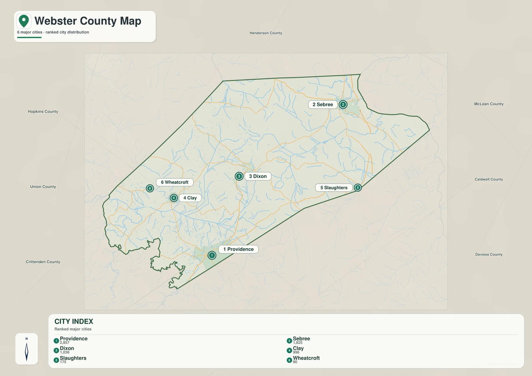
The city-distribution map removes most road detail and makes the county’s settlement pattern easy to see. Providence is the southern marker, Sebree is far to the northeast, and Dixon occupies the central interior. Clay and Wheatcroft sit relatively close together on the west, while Slaughters marks the eastern edge.
Neighboring county labels add regional context. Henderson County lies north, McLean and Caldwell Counties are on the eastern side, Crittenden County is southwest, and Union and Hopkins Counties appear to the west and south. Those surrounding names help explain the long east–west shape of Webster County and the spacing between its communities.
The population figures printed in the city index belong to the source snapshot used to create the map and should not be treated as current official totals. Recent demographic work should use the U.S. Census Bureau. The value of this file is spatial: it shows where the six major community references sit inside the county and how far apart they appear.
Deer Creek, Knoblick Creek, and smaller tributaries cut across the interior
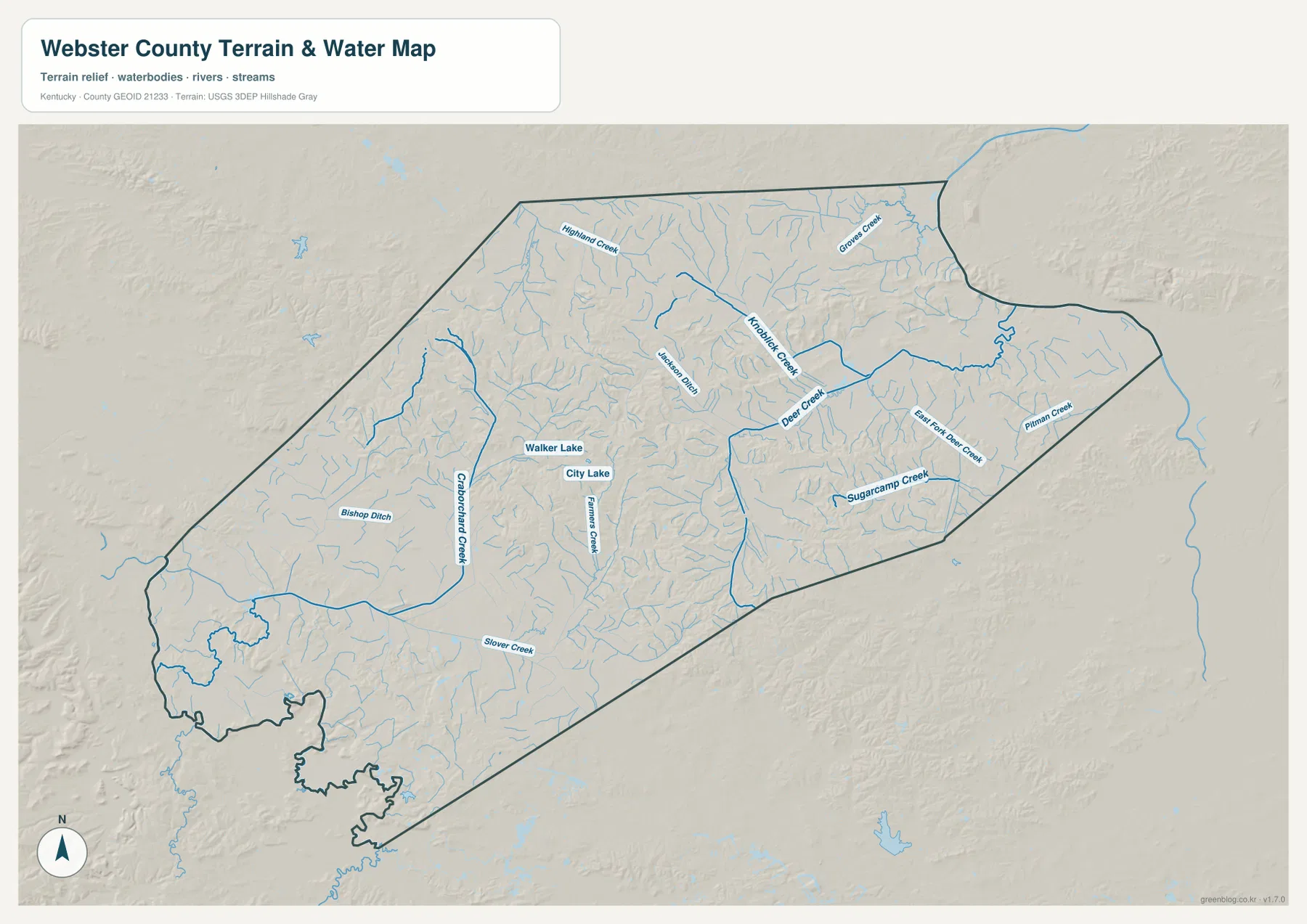
Webster County does not have one large river dominating the map. Instead, several medium and small streams spread across the interior. Deer Creek is one of the most prominent, with East Fork Deer Creek and Knoblick Creek nearby. Pitman Creek and Sugarcamp Creek occupy the southeastern side, creating long low corridors through otherwise rolling ground.
Crab Orchard Creek runs through the west-central area, while Slover Creek follows a long course across the south. Highland Creek and Groves Creek appear in the north, and Bishop Ditch marks a smaller drainage feature toward the west. Many unnamed blue lines branch away from these waterways, showing how extensively short stream valleys divide the county.
Walker Lake and City Lake sit close together near the middle of the county, and Sullens Pond is labeled farther north. These small water bodies are minor compared with a large reservoir, but they help locate the interior drainage system. Comparing the water map with the elevation file also shows how many named creeks occupy the lowest ground between ridges.
This file is intended to show relative water locations, not flood risk, water depth, navigation, legal shoreline boundaries, or parcel ownership. Current specialized agency data is required for those purposes.
Relief from 103 to 196 meters creates a patchwork of lowlands and short ridges
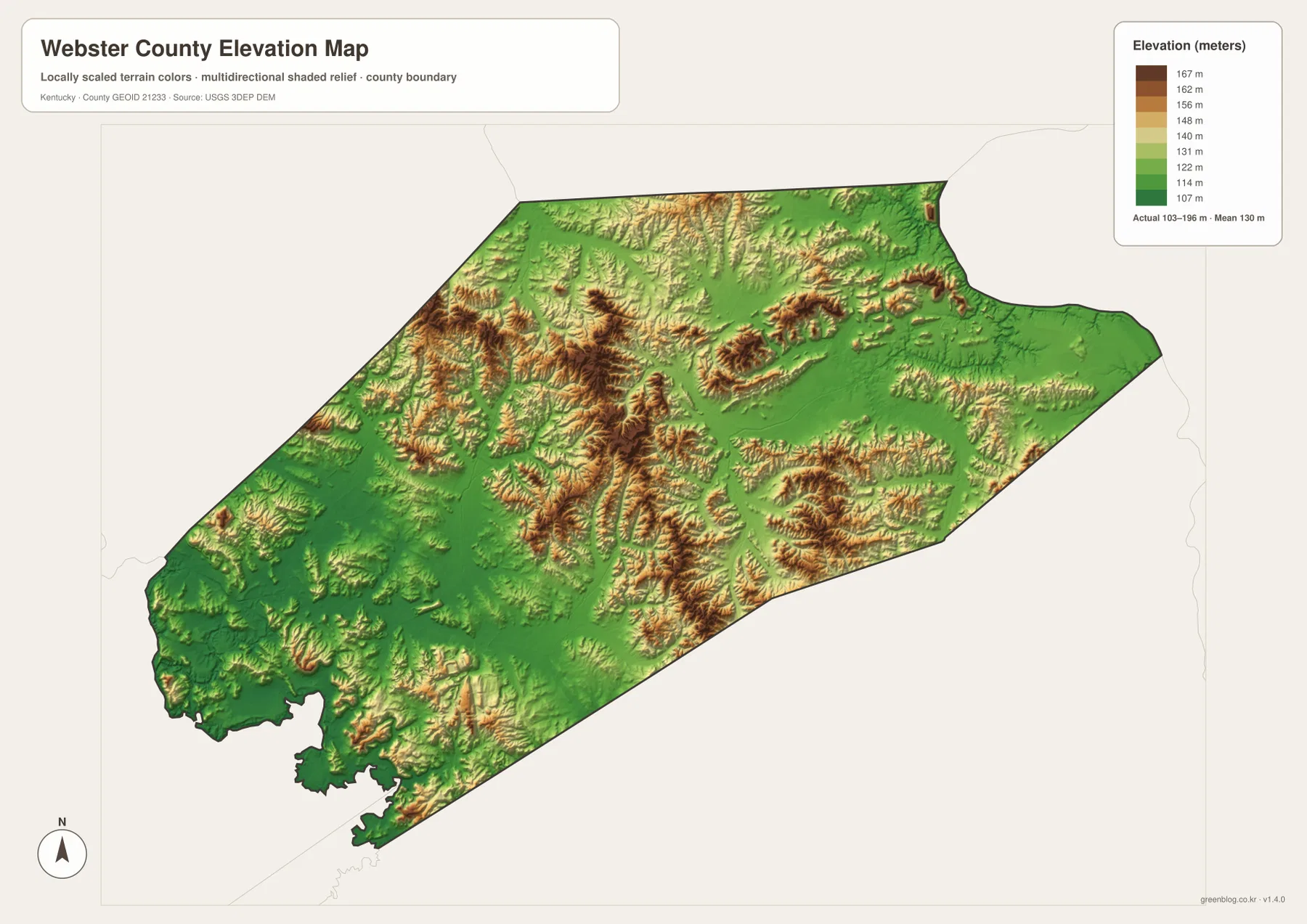
The elevation legend reports an actual range of about 103 to 196 meters, with a mean near 130 meters. Green marks the lower ground, while yellow, orange, and brown represent higher ridges. The central and northwestern interior contains many of the strongest clusters of higher relief, broken apart by narrow green creek valleys.
The eastern and northeastern side contains broader low areas, although small ridge groups still appear near Deer Creek and south of Slaughters. Around Dixon, higher and lower ground sits close together, which fits the winding local road pattern seen on the general map. The county is not mountainous, but the repeated short ridges are strong enough to shape roads and drainage.
Clay and Wheatcroft sit among mixed terrain in the west, while the far southwest drops back into lower greens. Providence and the southern side also contain broad lower areas cut by small streams. The contrast across the county is therefore less about one high mountain range and more about many compact ridge groups separated by shallow drainage corridors.
The 103–196 meter range is useful for county-scale comparison, not survey or engineering work. Building elevations, road design, mining grades, and drainage calculations require higher-resolution source data and, where necessary, professional field measurements.
A Providence–Dixon–Sebree route highlights the county’s changing terrain
Starting at Providence and moving toward Dixon, US 41A and the KY 120/KY 270 area provide useful road references. The water map adds Crab Orchard Creek and a dense network of small tributaries, while the elevation map shows short ridges alternating with lower valleys. The layers explain why the route network is not simply a set of straight lines.
Northeast from Dixon toward Sebree, KY 283 and KY 56 help organize the road view. Knoblick Creek and Deer Creek become stronger water references, and the elevation surface gradually opens into broader low areas toward the east. Sebree also connects toward the Slaughters and Onton side, making it a useful anchor for the northeastern quarter of the county.
Clay and Wheatcroft provide a western comparison. They are relatively close together on the city map, but the water and elevation files show numerous short valleys and ridge segments around them. Looking at all three areas—south, northeast, and west—makes Webster County’s internal variation much clearer.
Choose the Webster County file that fits the task
The general county map is the best starting point for communities, route numbers, and the county outline. The city map is cleaner when the six major settlement references are all that matter. The terrain-and-water file is useful for Deer Creek, Knoblick Creek, and the smaller drainage network, while the elevation map makes the 103–196 meter relief easiest to compare.
- County map: Use it for Providence, Dixon, Sebree, Clay, Slaughters, Wheatcroft, US 41A, KY 56, KY 120, KY 132, KY 283, KY 370, and the county boundary.
- City map: Use it to compare the six major city references and the directions of Henderson, McLean, Caldwell, Crittenden, Union, and Hopkins Counties.
- Terrain and water map: Use it for Deer Creek, East Fork Deer Creek, Knoblick Creek, Sugarcamp Creek, Crab Orchard Creek, Slover Creek, Walker Lake, and City Lake.
- Elevation map: Use it to compare the approximately 103–196 meter relief, especially the ridge clusters in the central and western interior and the lower east and southwest.
Each original JPG measures 3638 × 2572 pixels in landscape orientation, preserving more road and creek labels than the web previews. Keeping the original aspect ratio is recommended for printing.
Frequently Asked Questions
Which map is best for Providence, Dixon, Sebree, and the main roads?
The general county map is the best choice because it combines the six major communities with US 41A, KY 56, KY 120, KY 132, KY 283, KY 370, and the county boundary in one view.
Where can I see Deer Creek and Knoblick Creek most clearly?
The terrain-and-water map shows Deer Creek, East Fork Deer Creek, Knoblick Creek, Sugarcamp Creek, Crab Orchard Creek, Slover Creek, Walker Lake, City Lake, and many smaller tributaries. It is a geographic reference rather than a flood, navigation, or legal-boundary map.
Can the 103–196 meter elevation map be used for surveying or engineering?
No. The elevation file is designed for county-scale comparison of low valleys and higher ridge groups. Construction, mining, drainage design, and property-level survey work require more precise source data and appropriate field measurements.
Map File Information
The ZIP contains high-resolution JPG versions of the Webster County general map, city map, terrain-and-water map, and elevation map. Use the previews to check Providence, Dixon, Sebree, the main routes, Deer Creek and Knoblick Creek, and the 103–196 meter relief before opening the original files.
- Included Files: Use only the versions confirmed in the article and supplied images
- File Type: Use the confirmed download contents
- Intended Use: Printing, education, presentations, and map-based projects
Related Maps
Sources and references
The geographic discussion is based primarily on the supplied Webster County maps, with official county, city, boundary, hydrography, and elevation sources used for context.
- Webster County, Kentucky official website — county government and local information.
- City of Providence official website — official city information and local services.
- U.S. Census Bureau TIGER/Line Shapefiles — official geographic boundary and road data.
- USGS National Hydrography — federal hydrography background for rivers, creeks, and water features.
- USGS 3D Elevation Program — federal elevation and terrain data program.
Green Map creates custom-edited map images using open geographic data sources such as geoBoundaries, Natural Earth, OpenStreetMap, and government open data. These maps are edited visual materials, not raw data files, and are provided for education, documents, presentations, and graphic reference.