Scott County sits in north-central Kentucky with Georgetown as its main urban center, a broader southern half, and a noticeably narrower northern section around Sadieville. This Scott County Kentucky Map page follows that shape through the county road network, the positions of Georgetown, Stamping Ground, and Sadieville, the many branches of the Eagle Creek system, and an elevation range of roughly 200 to 326 meters. High-resolution JPG versions of the maps are available in the ZIP download after the web previews.
The county changes character over a relatively short distance. Georgetown is surrounded by the densest road pattern, including U.S. 25 and I-75, while Stamping Ground lies west of that corridor among rural roads and shallow valleys. Farther north, the outline tightens around Sadieville and the road network becomes more dispersed. The water and elevation layers add another part of the picture: small tributaries occupy many low corridors, with rolling ridges between them rather than one continuous flat surface.
Table of Contents
Georgetown as the road reference point for Scott County
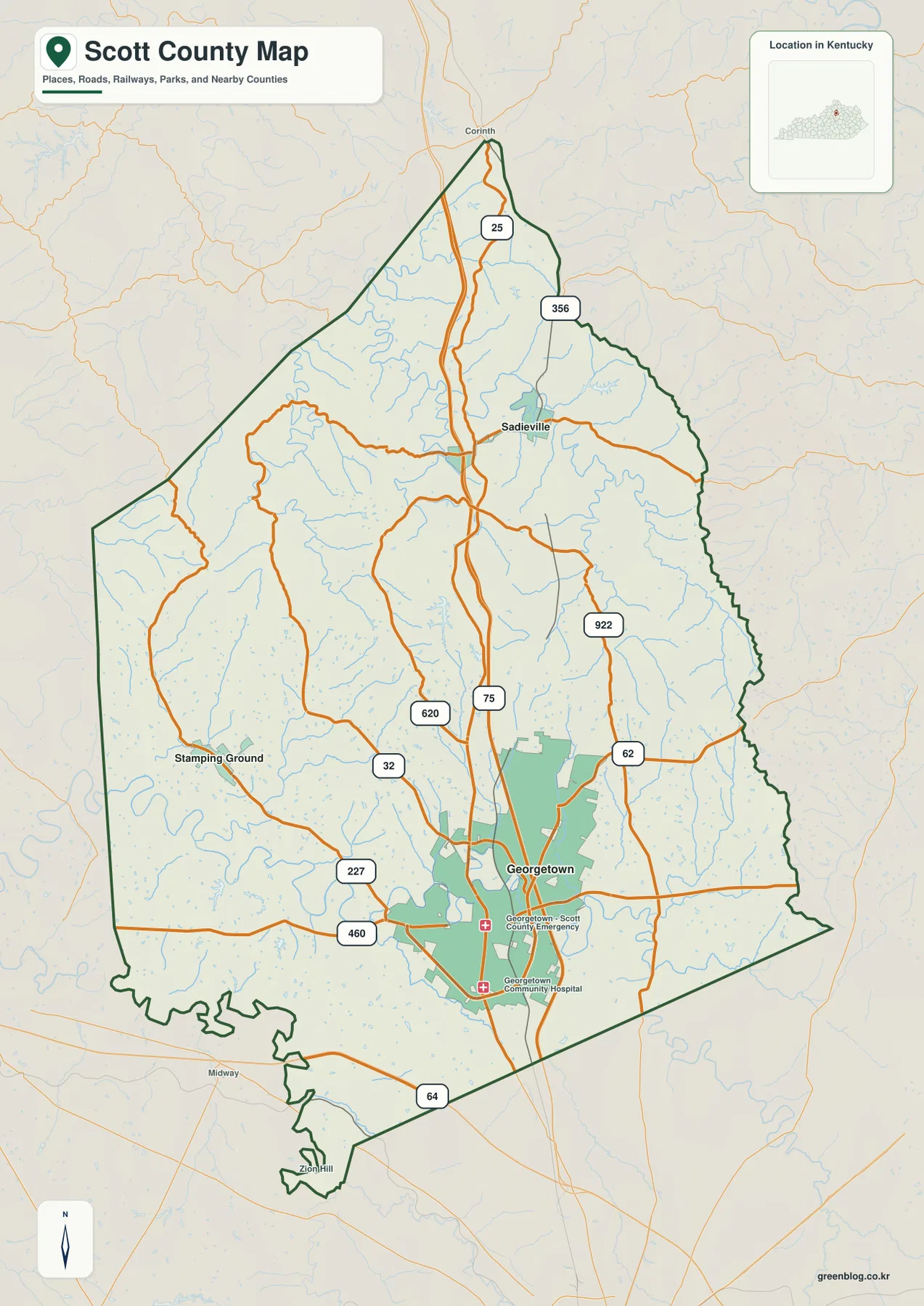
Georgetown provides the clearest starting point for reading the county map. Its developed area occupies the south-central part of Scott County, where U.S. 25 and I-75 pass through or near the city before continuing north. KY 62 heads east from the Georgetown area, while U.S. 460 and KY 227 lead westward. KY 620, KY 922, and smaller roads spread into the surrounding countryside, so the map shows both the regional routes and the local connections without separating them into different diagrams.
North of Georgetown, U.S. 25 continues through the long central portion of the county toward Sadieville. KY 356 turns east near Sadieville, and Corinth appears close to the narrow northern end as another orientation point. I-75 remains important for north-south travel, but the page is not a live navigation product; it does not show traffic, construction, lane closures, or current exit conditions. Its value is in showing how the main routes fit inside the county boundary and how they relate to the named communities.
Stamping Ground sits on the western side of the broader southern half. KY 32 crosses the area from east to west, while KY 227 bends toward Georgetown and the south. A finer web of rural roads fills the space between those routes. Midway is labeled just beyond the southwestern edge and Zion Hill appears farther south, which helps establish the Woodford County direction without implying that every visible label lies inside Scott County.
The boundary itself matters because Scott County is not a simple rectangle. It is broad around Georgetown and Stamping Ground, then tapers toward the north, with irregular bends along the southwestern and eastern sides. Looking at roads and boundary together makes it easier to distinguish the Georgetown side of the county from the western Stamping Ground area, the northern Sadieville section, and the edges facing Fayette, Woodford, Franklin, Bourbon, Harrison, Grant, and Owen counties.
Georgetown, Stamping Ground, and Sadieville on one simplified view
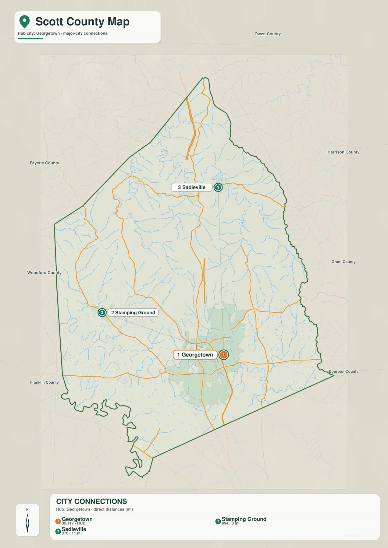
The city-connection map strips away many small road labels so the three featured communities can be compared quickly. Georgetown is in the south-central part of the county, Stamping Ground is west of it, and Sadieville is farther north. The map gives approximately 8 miles from Georgetown to Stamping Ground and about 11 miles from Georgetown to Sadieville. Those numbers are straight-line distances shown by the graphic, not driving distances, so a road trip between the same places will usually be longer.
Georgetown and Stamping Ground look close on the simplified map, yet the full county map adds the roads and terrain that separate them. U.S. 460 and KY 227 provide westward orientation from Georgetown, and KY 32 crosses the Stamping Ground area. Between the two are rural roads, stream valleys, and rolling ground. For that reason, the simplified map works well for relative position, while the county map is more informative when the question is how the places are connected by roads.
Sadieville occupies a different setting. It lies in the narrower northern part of Scott County, where U.S. 25 and KY 356 are the most obvious nearby route references. Large developed areas become less prominent north of Georgetown, while local roads and creek corridors remain visible. The difference is easy to see when the city view is compared with the county map: the southern half is organized around Georgetown, while the north contains smaller settlements stretched through a more confined section of the county.
Neighboring county labels make the simplified map useful beyond the three towns themselves. Fayette County lies to the southeast, Woodford County to the southwest, Franklin County to the west, Owen County to the northwest, Grant County to the north, Harrison County to the northeast, and Bourbon County to the east. A reader who already knows Lexington, Frankfort, or another nearby destination can use those directions to place Scott County in a wider regional context.
Eagle Creek branches and the county’s closely spaced valleys
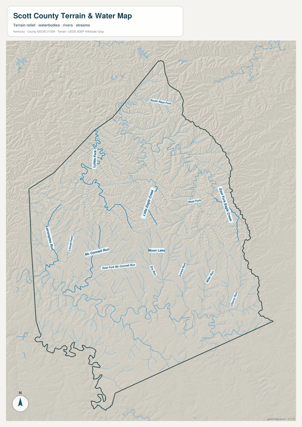
Scott County does not have one large river or reservoir dominating the supplied water map. Instead, the strongest pattern is a dense network of small streams. East Fork Eagle Creek extends along the eastern side, with West Fork shown to its west. Little Eagle Creek is prominent nearer the middle of the county, and Lytles Fork winds through the northwestern half. Numerous smaller branches feed those named waterways, dividing the rolling uplands into many short ridges and shallow valleys.
Other names help separate the network into recognizable areas. South Rays Fork crosses the northern section, while Lecomptes Run and Long Fork appear on the western side. Mc Connell Run and East Fork Mc Connell Run lie southwest of the center, and Dry Run, Lanes Run, Miller Run, and Griffin Run occupy parts of the south and southeast. Even where the labels become small, the blue stream lines remain frequent, showing that local drainage is spread throughout the county rather than concentrated in a single channel.
Moon Lake appears as a small water body near the south-central area, but the tributaries tell more about the county’s terrain than the lake itself. Many blue lines follow lower corridors, with ridges occupying the ground between them. When the water layer is placed beside the elevation map, the stream courses often match green or lighter low areas. That connection helps explain why some local roads bend along valleys or cross streams repeatedly instead of following a rigid rectangular grid.
The water layer is intended for county-scale geographic reference. It does not define flood-hazard zones, legal stream boundaries, parcel limits, water depth, water quality, or navigation conditions. Small channels can also be simplified at this scale. Flood safety, engineering, property, or development decisions should therefore rely on the current official datasets created for those purposes rather than on the general map shown here.
From roughly 200 m creek bottoms to 326 m rolling uplands
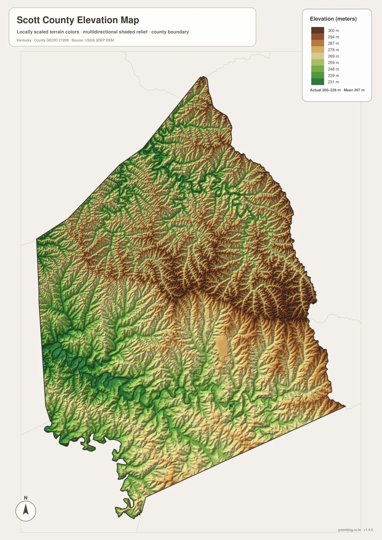
The elevation map shows an actual mapped range of about 200 to 326 meters, with a mean near 267 meters. Greens mark the relatively lower parts of Scott County, while yellow, tan, and brown represent progressively higher ground. Lower colors appear in parts of the southwest and along several stream valleys, whereas higher brown ridges are more common toward the east and northeast. Georgetown lies in a mixed zone rather than on a uniformly flat surface.
The narrow northern section contains short ridges separated by creek corridors, and similar patterns appear around East Fork Eagle Creek and Little Eagle Creek. Low ground follows the channels while higher terrain remains between them. The total mapped difference is greater than 100 meters, but the county does not read as a single mountain block. Its topography is better described as repeated low valleys and rounded uplands spread across the county.
South-central Scott County around Georgetown contains a broad mixture of lower and moderate elevations. Higher colors become more frequent toward the east and northeast, while the western side around Stamping Ground combines valley floors with moderate ridges. Near Sadieville, the narrowing boundary places several valleys and uplands within a smaller east-west width. Comparing this surface with the road map shows why major routes can maintain long north-south paths while many local roads curve around shorter ridges and creek crossings.
This elevation layer is generalized for county-scale comparison. It cannot provide the precise elevation of a building site, establish a construction grade, design drainage, or settle a surveying question. Those tasks require higher-resolution source data and professional measurement. For classroom use, regional orientation, or trip planning, the 200–326 meter range is still informative because it clearly separates many creek bottoms from the higher rolling ground between them.
Picking the Scott County file that fits the task
Use the county map when roads and boundary matter together: Georgetown, Stamping Ground, Sadieville, U.S. 25, I-75, U.S. 460, KY 62, KY 32, KY 227, and the full county outline all appear in the same view. The simplified city map is better when the main question is where the three featured communities sit relative to one another and to neighboring counties. The water layer concentrates on Eagle Creek tributaries and small valley systems, while the elevation layer separates lower creek corridors from higher rolling ridges.
- County map: Georgetown, Stamping Ground, Sadieville, U.S. 25, I-75, state routes, and the complete county boundary.
- City-connection map: the three featured communities, the 8-mile and 11-mile straight-line distances from Georgetown, and neighboring county directions.
- Water and terrain map: East Fork Eagle Creek, Little Eagle Creek, Lytles Fork, South Rays Fork, Mc Connell Run, and the smaller tributary valleys.
- Elevation map: the distribution of lower valleys and higher rolling ground across the approximately 200–326 m range.
For a classroom or presentation, Georgetown can first be located on the county map, then Stamping Ground and Sadieville can be compared on the simplified city view. Placing the water and elevation maps beside each other adds the physical setting: streams occupy many of the lower corridors, and ridges separate one drainage line from the next. That sequence keeps road, settlement, water, and relief information legible instead of crowding every label onto a single image.
Each original JPG measures 2572 × 3638 pixels, leaving more room for minor road numbers, tributary names, and shaded relief than the reduced web previews. A boundary-and-road image can stand alone in a general Scott County handout, while the water and elevation files work well together when the subject is physical geography. Selecting only the file or pair needed for the topic also makes printed labels easier to read.
Frequently Asked Questions
Which map is simplest for comparing Georgetown, Stamping Ground, and Sadieville?
The city-connection map gives the quickest comparison. Georgetown is shown in the south-central part of the county, Stamping Ground to the west, and Sadieville to the north, with straight-line distances of about 8 and 11 miles from Georgetown. Use the county map as well when you need the actual road context provided by U.S. 25, U.S. 460, KY 227, KY 32, and other routes.
Where can I see the smaller Eagle Creek tributaries?
The water and terrain map is the most detailed choice for that purpose. It labels East Fork Eagle Creek, Little Eagle Creek, Lytles Fork, South Rays Fork, Mc Connell Run, and several additional streams while showing the valleys around them. It is a regional reference layer, not a flood map or a legal description of water boundaries.
Is the 200–326 meter elevation map precise enough for surveying or construction?
No. The elevation surface is generalized to compare lower valleys with higher rolling ground across Scott County. Precise site elevations, construction grades, drainage design, and surveying decisions require higher-resolution source data and professional field measurement.
Sources and reference information
Road, settlement, water, and elevation descriptions are based on the supplied Scott County map assets. County background and the types of geographic data represented on the maps were checked against the official resources below.
- Scott County Fiscal Court – About Us — Official county background and history.
- Georgetown/Scott County Tourism — Official local destination and regional information for Georgetown and Scott County.
- U.S. Census Bureau TIGER/Line Shapefiles — Official U.S. geographic resources for county boundaries, roads, and related features.
- USGS National Hydrography — Official reference data for streams, rivers, lakes, and hydrographic features.
- USGS 3D Elevation Program — Official U.S. elevation data and terrain-model information.
Map File Information
The ZIP contains high-resolution JPG versions of the Scott County boundary and road map, city-connection map, water and terrain map, and elevation map. Use the Georgetown road network, Eagle Creek tributaries, and 200–326 m relief shown above to select the file that fits your print or reference project.
- File Type: ZIP containing 4 JPG files
Related Maps
Green Map creates custom-edited map images using open geographic data sources such as geoBoundaries, Natural Earth, OpenStreetMap, and government open data. These maps are edited visual materials, not raw data files, and are provided for education, documents, presentations, and graphic reference.