Martin County occupies a rugged corner of eastern Kentucky where narrow stream valleys and closely spaced ridges shape nearly every road and settlement. Inez is the clearest central reference, while Warfield sits farther east near the county boundary. The general map also labels Milo and Laura and shows routes 645, 3, 40, 908, and 292 threading through the hill country. This page explains the settlements, roads, creeks, and elevation shown on the supplied maps, and the original high-resolution JPG map files can be downloaded together in a ZIP archive for printing, classroom work, presentations, or offline reference.
Kentucky.gov identifies Inez as the county seat of Martin County and describes it as being in the coal fields of eastern Kentucky. That description fits the map well: roads and waterways converge around Inez, while Warfield occupies a separate eastern valley setting. The terrain-and-water map labels Rockcastle Creek, Stafford Fork, Rockhouse Fork, Middle Fork, Wolf Creek, Emily Creek, and many smaller tributaries. The elevation surface shows just how tightly low valleys and high ridges alternate across the county.
Table of Contents
Routes 3 and 40 converge around Inez before spreading through the valleys
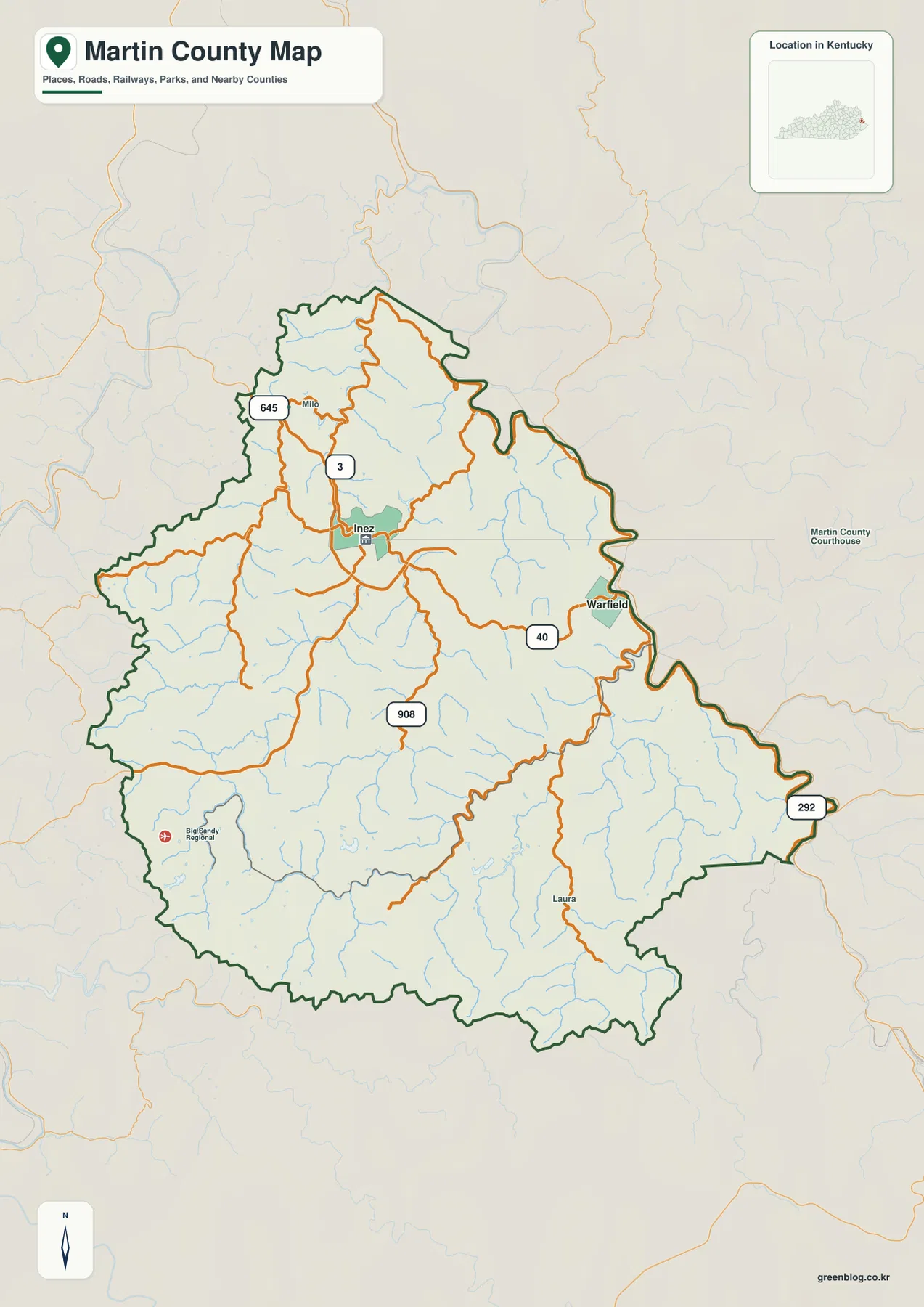
Inez is the easiest place to locate on the general county map. Route 3 connects the north-central and southern interior, while route 40 heads east toward Warfield. Route 645 appears near Milo in the northwest, route 908 runs through the central-southern part of the county, and route 292 reaches the southeastern boundary. The road network immediately shows that Martin County is not a grid: routes bend repeatedly because they follow lower ground between steep ridges.
The relationship between roads and valleys is especially clear around Inez. Numerous small tributaries converge close to the town, and roads use those low corridors to reach the surrounding communities. Route 40 toward Warfield follows a similarly winding course along the eastern side. A place that looks close in straight-line distance can require a longer drive because the road must stay within valleys or use limited ridge crossings.
Laura provides a useful southeastern reference near the route 292 corridor. Milo gives a contrasting point in the northwest, while the Big Sandy Regional marker appears in the southwestern part of the map. A Martin County Courthouse label is shown outside the mapped boundary as surrounding context, but the official county-seat reference remains Inez. Keeping Inez as the main administrative anchor avoids confusing the map’s contextual labels with the actual county center.
The general map is intended for geographic orientation, not live navigation. Construction, closures, and current road conditions are outside its scope. In this kind of ridge-and-valley terrain, current route information is especially important because detours can add substantial distance.
Inez and Warfield define two distinct settlement reference points
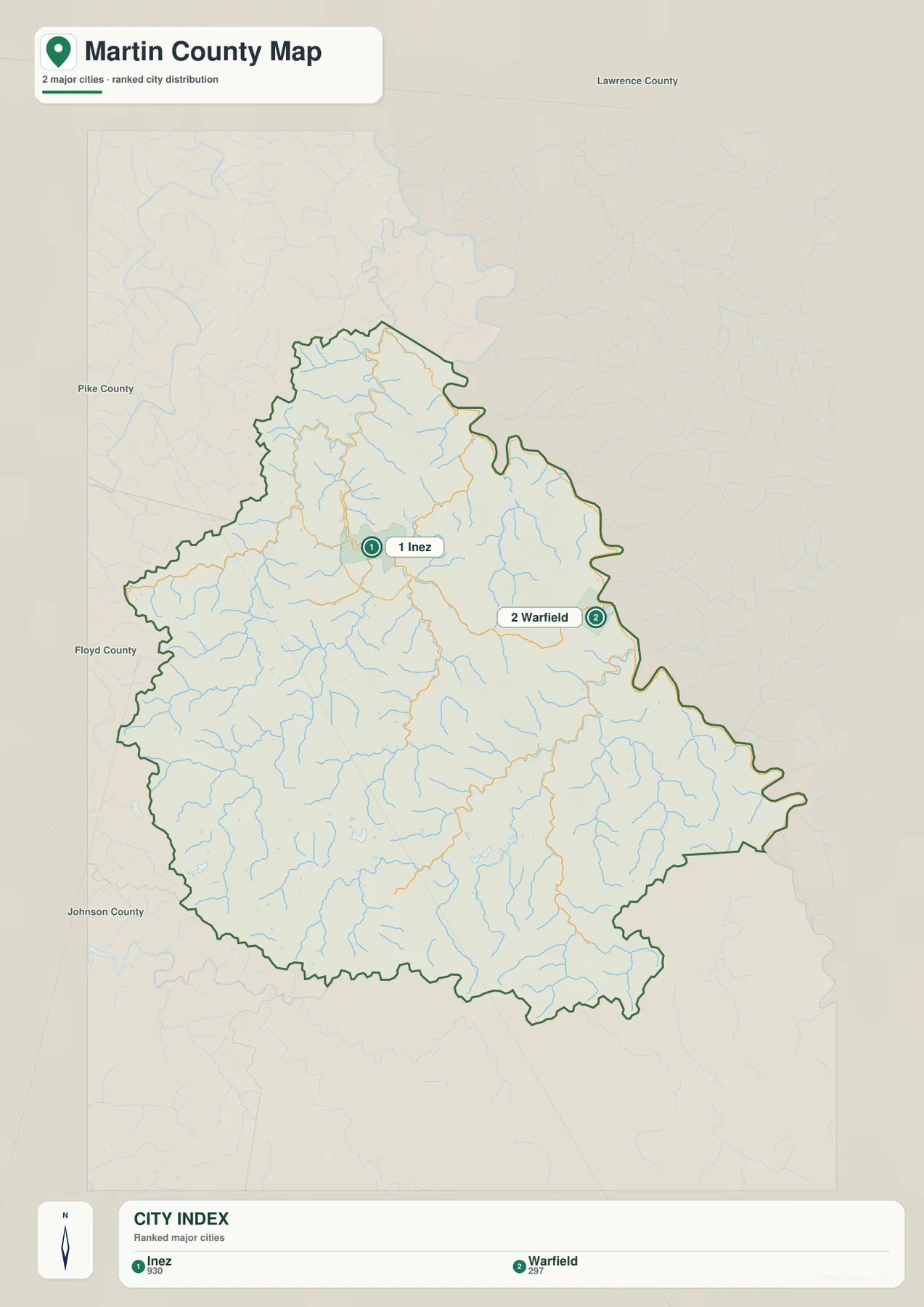
The city-distribution map ranks Inez first with a population label of 930 and Warfield second with 297. The two cities do not form one compact urban area. Inez sits in the north-central interior, while Warfield is close to the eastern edge in a separate valley. That spacing is important because the county is organized around narrow valleys rather than one broad plain.
Inez functions as the administrative and road-network reference, while Warfield is more useful for understanding the eastern side. Route 40 links their general directions, but the terrain between them contains many small streams and ridges. The simplified city map strips away most road numbers and makes the separation of the two settlement areas easy to see.
Neighboring county labels provide additional orientation. Lawrence County lies north, Pike County to the east, Floyd County to the west, and Johnson County to the southwest. These names place Martin County among the rugged counties of eastern Kentucky. The irregular eastern boundary also emphasizes how close Warfield is to the edge of the state-facing side of the county.
The population labels are useful as scale references rather than the main subject of the page. Smaller communities and rural roads are still present across the county even though only two ranked cities appear on this map. For those details, the general road map is the better companion.
Rockcastle Creek, Middle Fork, and Wolf Creek reveal the valley network
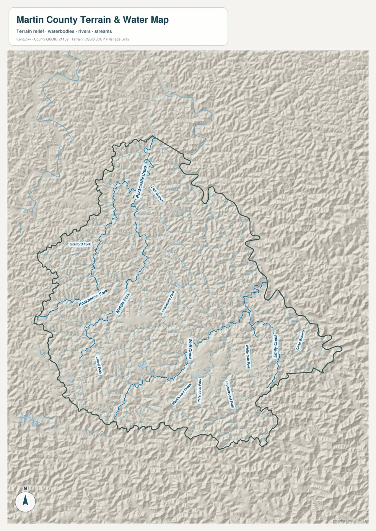
The terrain-and-water map makes Martin County’s drainage network far more obvious than the road map. Rockcastle Creek bends through the northern section, with Left Branch nearby. Stafford Fork and Rockhouse Fork extend through the western interior, while Middle Fork forms a long north-south valley closer to the center. Numerous smaller blue lines fill the spaces between the named streams.
Farther south and east, the map labels Coldwater Fork, Wolf Creek, Meathouse Creek, and Peter Cave Fork. White Oak Fork and Pigeonroost Fork occupy separate southeastern valleys, while Emily Creek and Long Branch provide strong reference features near the eastern boundary. Laurel Fork appears in the southwest. Together these names show how extensively the county is divided into narrow drainage basins.
The water network also explains the road pattern. Rockhouse Fork and Middle Fork occupy long low corridors that roads can follow, and the Warfield side shows a similar relationship around Emily Creek and Long Branch. Ridges separate adjacent streams, so moving between two nearby valleys can require a winding road or a specific crossing point.
This map is meant for geographic reference rather than flood prediction, water depth, water quality, fishing regulations, or access decisions. Current stream conditions and safety information should come from the agencies responsible for local waterways and emergency management.
Elevation from 170 to 487 meters highlights tightly packed ridges and hollows
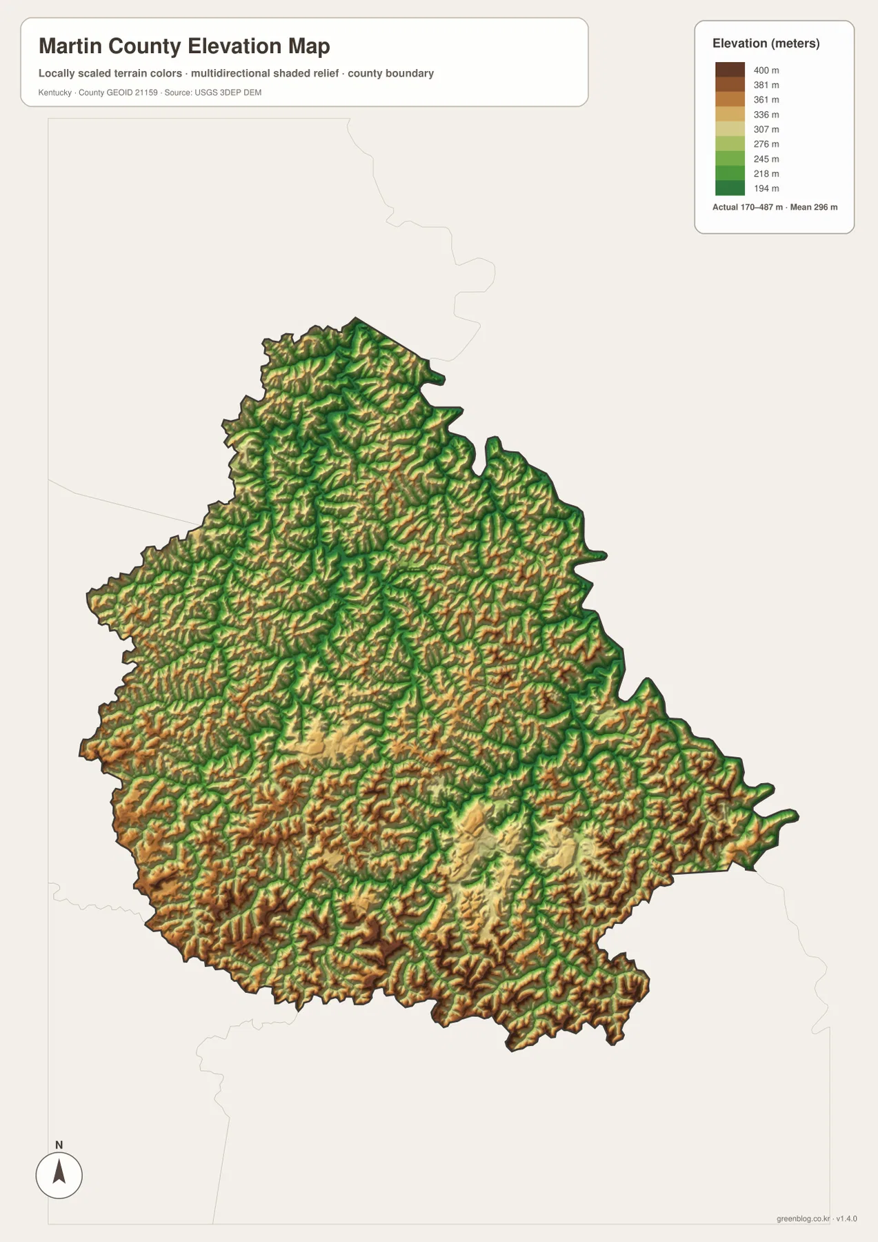
The elevation map reports an actual county range of about 170 to 487 meters and a mean near 296 meters. Lower green terrain follows the stream valleys, while yellow, orange, and brown ridges repeat across nearly the entire county. There are few broad level areas. Instead, narrow low corridors and steep ridge systems alternate at short intervals.
The north-central area around Inez contains some of the more connected low terrain, but elevation rises quickly on either side of the valleys. That helps explain why roads and settlement occupy valley bottoms rather than ridge crests. Even within a short distance of town, the surface changes from low green corridors to much higher orange and brown ground.
The southwestern and southern sections contain broad areas of higher ridges cut by green valleys. Wolf Creek and nearby tributaries carve deep corridors into that terrain. The eastern Warfield side shows the same basic contrast around Emily Creek and Long Branch. With more than 300 meters between the mapped low and high elevations, relief can change substantially over short distances.
The elevation colors are intended for county-scale comparison and should not be treated as survey-grade measurements for a parcel, road, structure, or construction site. Engineering, drainage design, and legal surveying should use current source elevation data or professional field measurements.
A practical way to move from Inez to Warfield and the southeastern valleys
A useful reading sequence begins in Inez. On the general map, locate routes 3 and 40, then note route 645 to the northwest and route 908 farther south. On the water map, find Rockcastle Creek and Middle Fork near the same broad area. The elevation view then shows why these road and water corridors occupy lower ground between repeated ridge systems.
For Warfield, follow route 40 east and then compare Emily Creek and Long Branch on the physical map. The eastern boundary is highly irregular, and narrow valleys continue right up to the edge of the county. The elevation map confirms that low stream corridors and high ridges remain tightly interlocked on this side.
For the southeastern section, Laura and route 292 provide a useful road reference. Wolf Creek, White Oak Fork, and Pigeonroost Fork help organize the water map in the same direction. Using one place across several map views is more effective than memorizing separate lists of roads, creeks, and elevations.
Choosing the best Martin County map for the question
Use the general county map when you need Inez, Warfield, Milo, Laura, numbered roads, and the full boundary in one view. The city-distribution map is cleaner when the goal is simply to compare the two ranked major cities and understand their separation within the county.
Choose the terrain-and-water map for Rockcastle Creek, Rockhouse Fork, Middle Fork, Wolf Creek, Emily Creek, and the many smaller tributaries. The elevation map is the strongest view for showing why those streams and roads wind so much, because it reveals the closely packed ridges between the valleys.
The WebP images in the article are optimized for browser viewing. The downloadable ZIP contains the original JPG maps at 2,572×3,638 pixels each, making them better suited to printing, classroom worksheets, presentations, and offline reference. These maps are general geographic resources rather than legal boundary records, flood studies, parcel surveys, or engineering plans.
Frequently Asked Questions
Should I start with Inez or Warfield when reading the maps?
Inez is the better starting point for countywide orientation because routes 3 and 40 meet near the main administrative center, and Kentucky.gov identifies Inez as the county seat. Warfield is more useful when the question concerns the eastern boundary and the valleys around Emily Creek and Long Branch. Starting in Inez and then moving east gives a clear progression.
Which map best shows Rockcastle Creek and Wolf Creek together?
The terrain-and-water map is the best choice. Rockcastle Creek is in the northern section and Wolf Creek is farther south, with Stafford Fork, Rockhouse Fork, Middle Fork, Coldwater Fork, Emily Creek, and other tributaries between them. It is the clearest single view of the county’s valley network.
Can the 170–487 meter elevation range be used for exact property heights?
No. The range summarizes the actual countywide elevations shown on the supplied map, with a mean near 296 meters. It is useful for comparing low stream valleys with surrounding ridges, but exact site elevations should come from current source data or professional surveying.
Map File Information
The ZIP archive contains the original high-resolution JPG versions of the Martin County road-and-boundary map, city-distribution map, terrain-and-water map, and elevation map. Each image is 2,572×3,638 pixels for printing, classroom work, presentations, and offline reference.
- File Type: 4 JPG files inside one ZIP archive
Related Maps
Sources and references
County government information is available from the official Martin County government website and the Kentucky.gov Martin County profile. Inez background is available from the Kentucky.gov City of Inez profile. For underlying geographic data, see the U.S. Census Bureau TIGER/Line Shapefiles, USGS National Hydrography, and the USGS 3D Elevation Program.
These maps are intended for geographic explanation, printing, and general reference. Legal boundary decisions, live traffic, flood safety, property surveying, and engineering work should rely on the latest authoritative information from the responsible public agency.
Green Map creates custom-edited map images using open geographic data sources such as geoBoundaries, Natural Earth, OpenStreetMap, and government open data. These maps are edited visual materials, not raw data files, and are provided for education, documents, presentations, and graphic reference.