Marion County lies in central Kentucky with Lebanon serving as the clearest hub for the surrounding communities of Loretto, Bradfordsville, St. Mary, and Raywick. The general map shows major routes including 52, 55, 68, 84, 49, and 337, while the physical maps reveal a dense network of creek valleys around Rolling Fork and North Rolling Fork. Elevation changes from lower western valleys to higher eastern and southeastern ridges. The original high-resolution JPG versions of the maps can also be downloaded together in one ZIP archive for printing, classroom work, presentations, or offline reference. High-resolution map files are available for download in the section below.
Lebanon is the easiest place to begin because several roads meet in the central part of the county. Loretto is northwest, St. Mary and Raywick lie to the west, and Bradfordsville sits toward the southeast. The western half contains many branching streams and relatively broad low corridors, while the eastern and southeastern side becomes more strongly dissected by ridges. Looking at settlement, water, and elevation together gives a clearer picture than treating the county as a simple road map.
Table of Contents
Lebanon anchors the county road network
The general county map places Lebanon at the center of the main road network. Route 52 runs east-west through the area, while routes 55 and 68 extend southward. Route 527 appears near Loretto in the northwest, route 84 crosses the St. Mary and Raywick side, and routes 337 and 49 serve the Bradfordsville area in the southeast. The map therefore makes Lebanon a practical starting point for tracing nearly every major direction across Marion County.
The road pattern is not a simple grid. West of Lebanon, many routes bend through creek valleys and rolling terrain. Toward Bradfordsville, the roads encounter a more pronounced ridge-and-valley landscape. Two places that look close in straight-line terms can require a longer drive because routes follow the lower terrain rather than crossing every ridge directly. Current navigation, closures, and construction should be checked with live transportation sources.
Loretto provides a useful northwestern reference near route 527. St. Mary lies west of Lebanon, with Raywick farther toward the county’s western side along route 84. Bradfordsville gives the opposite southeastern reference and helps show how far the county extends beyond the central Lebanon area. These settlements are useful anchors because each sits in a different part of the road and creek network.
Outside the county, labels such as Springfield, New Hope, New Haven, Mackville, and Perryville help with regional orientation. Washington County lies north, Boyle and Casey counties are to the east, and Nelson and Larue counties appear to the west and southwest. The general map is the best single view for combining those surrounding directions with Marion County’s own roads and boundary.
Straight-line connections from Lebanon to four surrounding communities
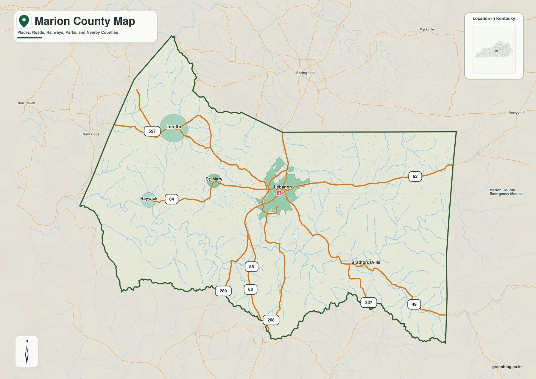
The city-connections map uses Lebanon as the hub and lists direct distances to four surrounding communities. Loretto is shown about 9 miles away, Bradfordsville about 8 miles, St. Mary about 5 miles, and Raywick about 10 miles. These values are straight-line distances between the mapped points, not driving distances along the road network. Actual trips can be longer because roads curve through the county’s rolling terrain.
Loretto lies northwest of Lebanon, St. Mary and Raywick are to the west, and Bradfordsville is southeast. Even though all four direct distances fall within roughly 5 to 10 miles, the surrounding landscapes differ. The Loretto and Raywick sides contain numerous small creeks and lower rolling country, while Bradfordsville leads toward higher terrain and a more pronounced ridge pattern. The simplified city map is therefore best for direction and spacing rather than travel conditions.
The supplied city map also labels Lebanon with 6,430 residents, Loretto with 683, Bradfordsville with 444, St. Mary with 147, and Raywick with 125. Those figures are useful for distinguishing the relative scale of the mapped communities, but the main purpose of the graphic is geographic orientation. Once Lebanon and the four surrounding places are familiar, the water and elevation maps become easier to navigate.
St. Mary and Raywick both occupy the western side but are not interchangeable reference points. St. Mary is closer to the central Lebanon area, while Raywick sits farther west. Bradfordsville provides the strongest southeastern counterpoint. This arrangement makes the city-connections map especially useful in presentations or lessons where the road numbers would add unnecessary visual detail.
Rolling Fork and named creeks divide the interior into valleys
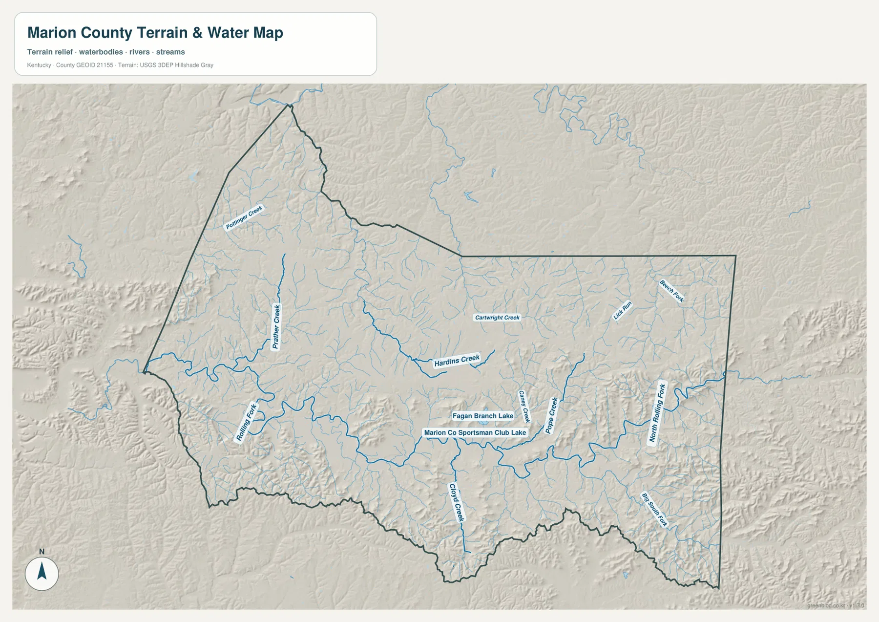
The terrain-and-water map makes Marion County’s valley network much easier to see. Rolling Fork is the dominant water corridor on the western side, while North Rolling Fork appears in the eastern and southeastern part of the county. Between them, Hardins Creek, Prather Creek, Pottinger Creek, and Pope Creek occupy long branching valleys. The result is a landscape where waterways and low terrain influence the shape of local roads and settlement corridors.
Pottinger Creek and Prather Creek are clear reference features in the northwest. Hardins Creek and Cartwright Creek cross the central interior, while Lick Run and Beech Fork appear farther east. In the southern half, Cloyd Creek, Casey Creek, and Pope Creek follow separate low corridors, and Big South Fork is labeled near the southeastern drainage system. These names help organize a map that otherwise contains many smaller unnamed tributaries.
Fagan Branch Lake and Marion Co Sportsman Club Lake provide two small water landmarks in the central-southern area. Casey Creek and Cloyd Creek are nearby, and the shaded relief shows that these water bodies occupy lower terrain between ridges. Locating the lakes first can make it easier to follow the surrounding creek network without trying to identify every small tributary at once.
A useful reading order is to find Rolling Fork and North Rolling Fork first, then add Hardins Creek, Pope Creek, and Casey Creek. This physical map is intended for geographic reference, not for flood forecasting, channel depth, water quality, fishing regulations, or private-access decisions. Current conditions should be checked with the agencies responsible for local waterways and public safety.
Elevation from 147 to 381 meters rises toward the east and southeast
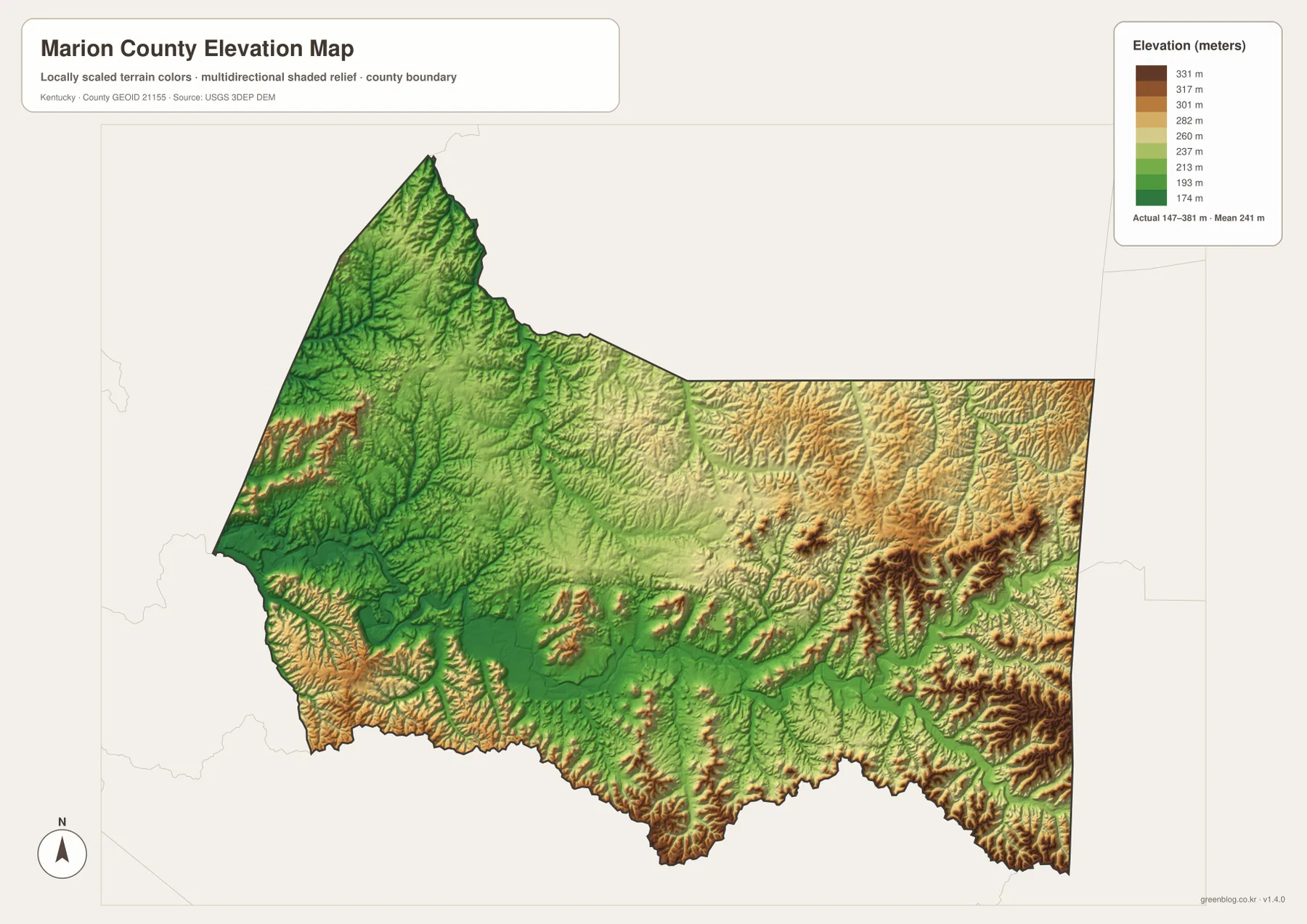
The elevation map reports an actual county range of about 147 to 381 meters and a mean near 241 meters. Lower green terrain is broadest in western and central stream valleys, while yellow, orange, and brown ridges become more common toward the east and southeast. The Bradfordsville side contains some of the strongest high-relief terrain, creating a clear contrast with the lower Rolling Fork corridor in the west.
The Loretto and northwestern areas contain large stretches of green and light-green terrain, although they are not completely flat. Small creeks carve narrow valleys between low ridges. The Rolling Fork corridor is also distinctly lower than much of the surrounding country, and its bends can be followed across the elevation surface as a connected low route.
Eastern and southeastern Marion County has a more rugged appearance. Long ridges are interrupted by the lower corridors of North Rolling Fork and its tributaries. Around Bradfordsville, the map shows repeated brown and orange ridge crests separated by green valleys. Comparing that area with the road map helps explain why routes 337 and 49 bend through the terrain instead of following a straight line.
The elevation colors are intended for county-scale comparison, not survey-grade site measurement. They are useful for distinguishing low stream valleys from higher ridge country, but they should not be used as exact elevations for a parcel, road, building site, or drainage structure. Engineering and legal work should rely on current source elevation data or professional field surveying.
Following the maps from Lebanon to the western valleys and southeastern ridges
A practical way to read Marion County is to start in Lebanon. On the general map, find routes 52, 55, and 68, then locate Loretto and Bradfordsville in opposite directions. Add St. Mary and Raywick from the city-connections map. Once those settlement references are fixed, the water map can be used to find Hardins Creek and Rolling Fork, showing how roads and communities relate to the lower valleys.
For the western side, Raywick and St. Mary work well with Rolling Fork and Prather Creek. Pottinger Creek provides another reference closer to Loretto in the northwest. On the elevation map, much of this side appears lower than the eastern ridge country, although smaller uplands still separate the creek valleys.
For the southeast, begin with Bradfordsville and routes 337 and 49. North Rolling Fork and nearby tributaries provide the water references, while the elevation view shows higher ridges tightly surrounding the lower drainage corridors. Following the same place through several maps makes the county easier to understand than memorizing unrelated lists of roads, streams, and elevations.
Choosing a Marion County map for print, class, or local reference
Use the general county map when Lebanon, surrounding communities, numbered roads, and the full boundary need to be visible together. The city-connections map is cleaner when the goal is simply to show how Loretto, Bradfordsville, St. Mary, and Raywick relate to Lebanon and to explain their straight-line distances.
Choose the terrain-and-water map when Rolling Fork, North Rolling Fork, named creeks, and the small lakes are the main subject. The elevation map is the strongest view for comparing lower western valleys with higher eastern and southeastern ridges. Placing the water and elevation maps side by side makes it easy to see how streams occupy the lower corridors between uplands.
The WebP images in the article are optimized for browser viewing. The downloadable ZIP contains the original JPG maps at 3,638×2,572 pixels each, which is better suited to printing, worksheets, presentations, and offline reference. These maps are general geographic resources rather than legal boundary records, flood studies, parcel surveys, navigation products, or engineering plans.
Frequently Asked Questions
Are the distances from Lebanon to Loretto, Bradfordsville, St. Mary, and Raywick driving distances?
No. The city-connections map shows straight-line distances of about 9 miles to Loretto, 8 miles to Bradfordsville, 5 miles to St. Mary, and 10 miles to Raywick. Actual driving distances can be longer because roads curve through the county and do not always follow the direct line between communities.
Which map is best for finding Rolling Fork and the named creeks?
The terrain-and-water map is the best choice. It shows Rolling Fork and North Rolling Fork together with Pottinger Creek, Prather Creek, Hardins Creek, Cartwright Creek, Pope Creek, Casey Creek, Cloyd Creek, and several smaller water features.
Can the 147–381 meter elevation range be used as an exact property elevation?
No. That range summarizes the actual countywide elevations shown on the supplied map, with a mean near 241 meters. It is useful for comparing lower western valleys with higher eastern and southeastern ridges, but exact site elevations should come from current source data or professional surveying.
Map File Information
The ZIP archive contains the original high-resolution JPG versions of the Marion County road-and-boundary map, city-connections map, terrain-and-water map, and elevation map. Each image is 3,638×2,572 pixels for printing, classroom work, presentations, and offline reference.
- File Type: 4 JPG files inside one ZIP archive
Related Maps
Sources and references
County government information is available from the official Marion County government website and the Kentucky.gov Marion County profile. Local visitor information is available from Visit Lebanon Kentucky. For underlying geographic data, see the U.S. Census Bureau TIGER/Line Shapefiles, USGS National Hydrography, and the USGS 3D Elevation Program.
These maps are intended for geographic explanation, printing, and general reference. Legal boundary decisions, live traffic, flood and water-safety questions, property surveying, and engineering work should rely on the latest authoritative information from the responsible public agency.
Green Map creates custom-edited map images using open geographic data sources such as geoBoundaries, Natural Earth, OpenStreetMap, and government open data. These maps are edited visual materials, not raw data files, and are provided for education, documents, presentations, and graphic reference.