Hardin County spans a broad part of north-central Kentucky, with Elizabethtown as the largest urban anchor and Radcliff, Vine Grove, West Point, Sonora, and Upton spread along different parts of the county. Fort Knox occupies a major area in the north, while I-65 and U.S. 31W provide a strong north-south reference through the central and southern sections. The maps on this page show roads, ranked cities, waterways, and elevation, and the four high-resolution JPG versions can be downloaded together in one ZIP for printing or close inspection. High-resolution map files are available for download in the section below.
Hardin County is especially useful to study with more than one map because its landscape changes noticeably from one part of the county to another. The Ohio River touches the far north, Rough River defines part of the western drainage, and the Nolin River reaches the south. Between those larger waterways are rolling uplands, smaller creek valleys, reservoirs, military land, and the developed Elizabethtown–Radcliff area. Looking at these features together makes the road network and settlement pattern much easier to understand.
Table of Contents
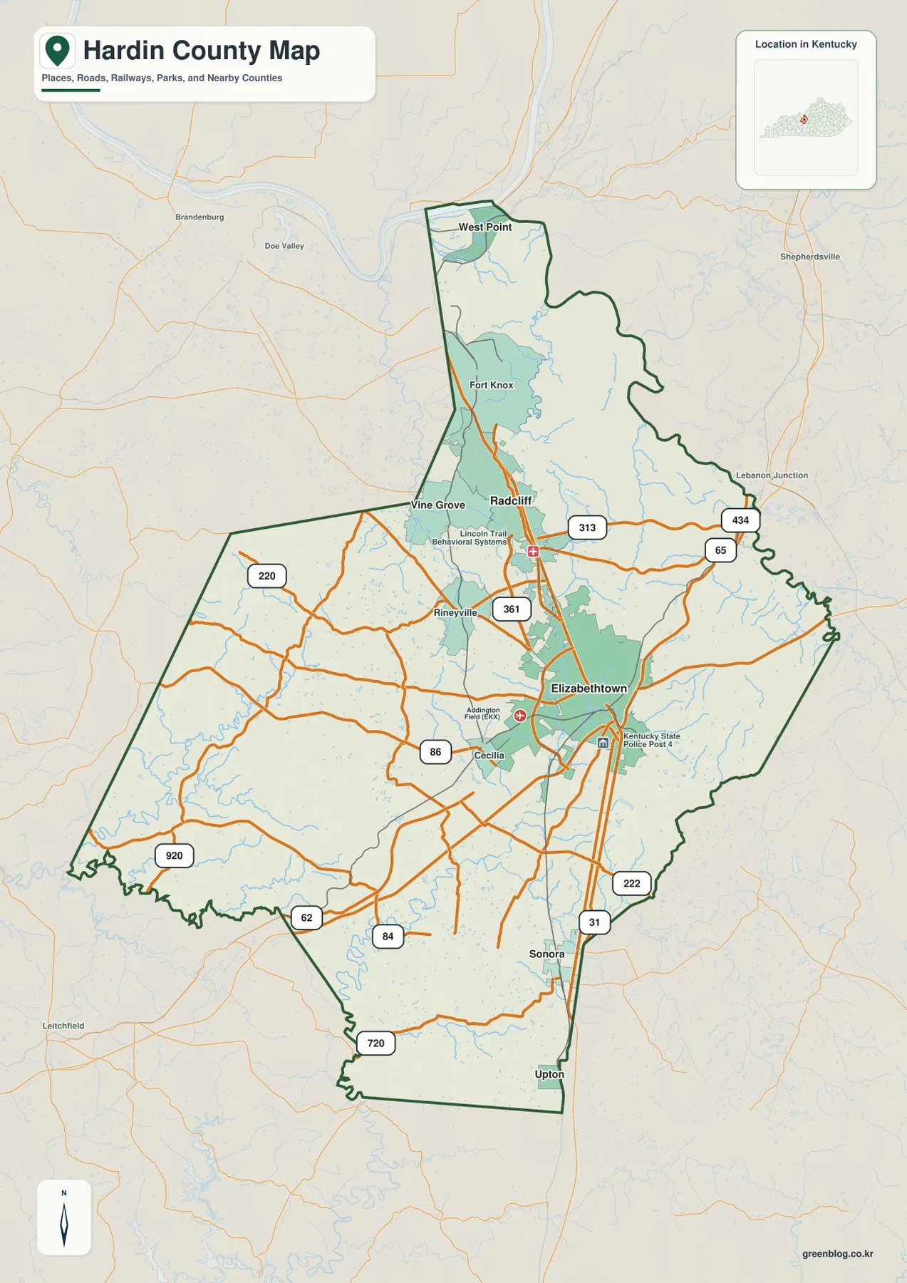
Elizabethtown anchors the road network while I-65 links the county north to south
Elizabethtown is the clearest road and place reference on the general county map. I-65 passes along the city’s eastern side and continues toward Radcliff and the Fort Knox area to the north, while the same corridor runs south toward Sonora and Upton. U.S. 31W and state routes such as KY 61, KY 86, KY 220, and KY 361 add local connections across the central and western parts of the county. Addington Field and the Kentucky State Police post are also labeled near Elizabethtown, making the city easy to identify even at a quick glance.
North of Elizabethtown, Radcliff and Vine Grove sit close together below Fort Knox. West Point is farther north, near the Ohio River, and has a different geographic setting from the Radcliff–Vine Grove cluster. The map also shows KY 313 leading through the northern developed area and KY 434 reaching toward the eastern edge near Lebanon Junction outside the county. These references help distinguish the county’s compact northern communities from the larger rural interior.
The western side is more open and contains fewer large city labels. Rineyville and Cecilia provide useful local anchors, while KY 86, KY 220, and KY 920 help trace routes through agricultural and rolling upland areas. Farther south, Sonora and Upton sit close to the I-65 and U.S. 31W corridor. If you are learning the county for the first time, it is practical to begin with Elizabethtown and then follow the major road corridors outward rather than trying to memorize every local highway at once.
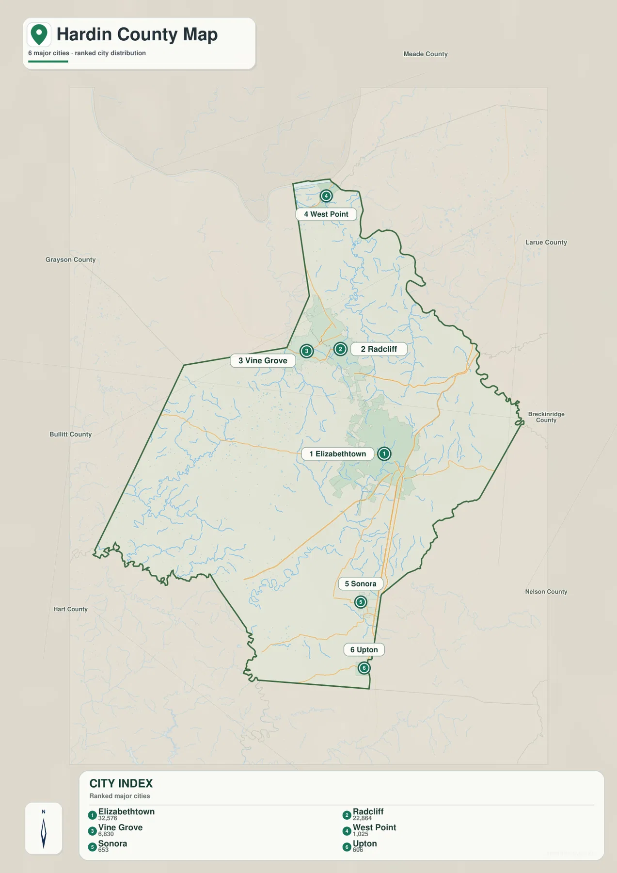
The six ranked cities form a northern cluster and a separate southern pair
The city index highlights six incorporated places: Elizabethtown, Radcliff, Vine Grove, West Point, Sonora, and Upton. The values printed on the map are 32,576 for Elizabethtown, 22,864 for Radcliff, 6,830 for Vine Grove, 1,025 for West Point, 653 for Sonora, and 606 for Upton. These numbers are best treated as map reference values for comparing relative city size; readers who need the latest population estimates should check current Census data separately.
The geography behind those rankings is just as useful as the numbers. Elizabethtown occupies the main central-southern urban position, while Radcliff and Vine Grove are closely grouped farther north below Fort Knox. West Point sits by itself near the Ohio River at the county’s northern tip. Sonora and Upton make a smaller southern pair along the main north-south transportation corridor. The result is a long county with several distinct settlement zones rather than one continuous band of development.
For navigation, the city index works best as a companion to the general map. It quickly shows which communities are largest and where they sit within the county boundary, but it intentionally omits many local roads and smaller place names. Use Radcliff and Vine Grove when orienting around Fort Knox, Elizabethtown for the central road network, and Sonora or Upton when working near the southern edge.
The Ohio, Rough, and Nolin river systems frame very different parts of the county
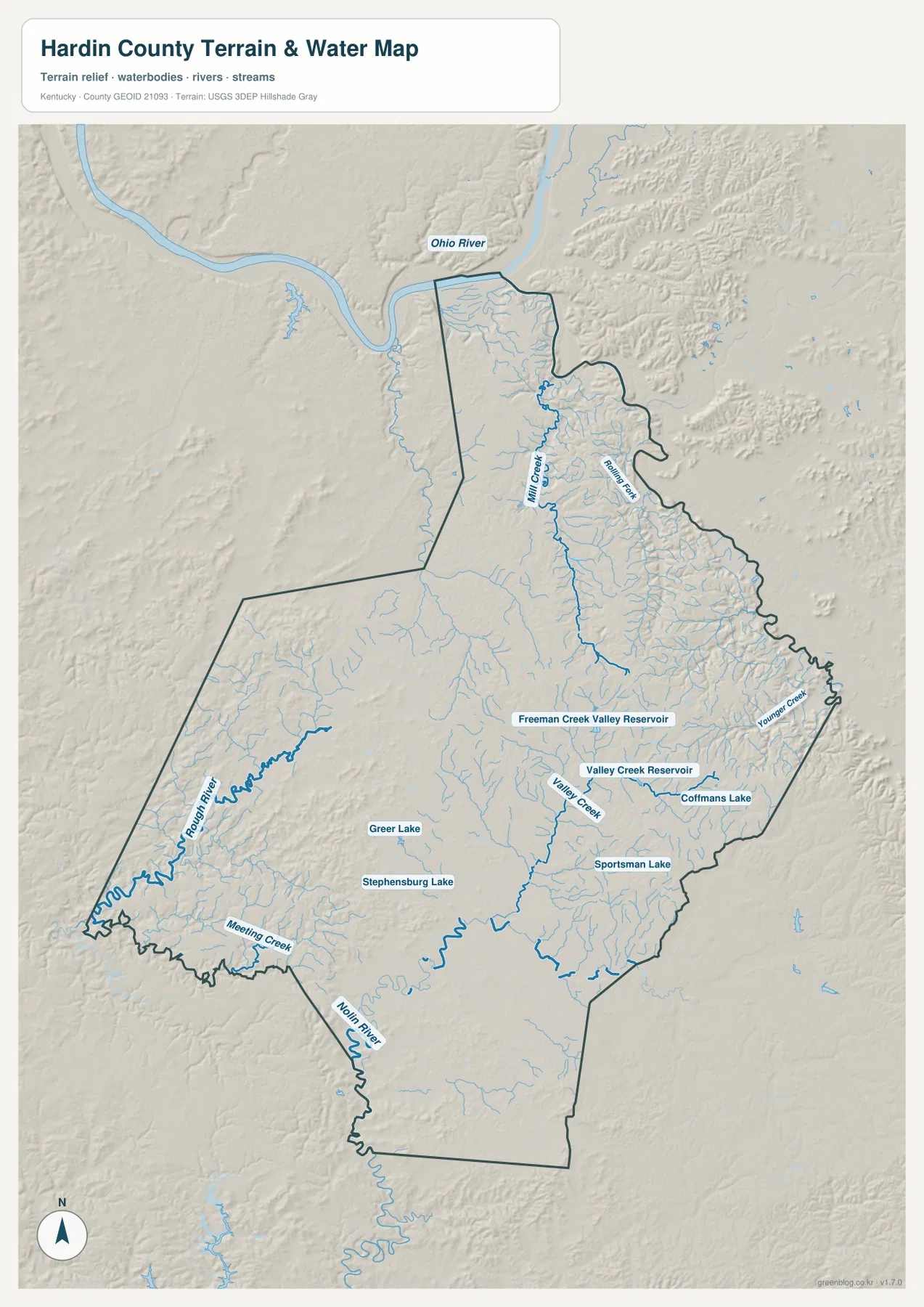
The terrain and water map shows the Ohio River along the far northern edge near West Point. From there, the northern interior is cut by Mill Creek and many smaller tributaries around the Fort Knox area. These channels occupy narrow valleys between ridges, which explains why this part of the county looks much more dissected on the hillshade than the flatter-looking road map might suggest.
On the western side, Rough River creates a separate drainage setting with a broad, winding channel near the county boundary. The south has another major reference in the Nolin River, while Meeting Creek crosses part of the southwestern interior. In the central and eastern sections, Valley Creek and Younger Creek are among the named streams, and the map also labels Freeman Creek Valley Reservoir, Valley Creek Reservoir, Coffmans Lake, Sportsman Lake, Greer Lake, and Stephensburg Lake. Those smaller water bodies are helpful landmarks in areas without large city labels.
This water map is particularly useful for understanding why local roads follow indirect routes. Many roads occupy creek valleys or cross between ridges, so their shape makes more sense when the drainage network is visible. The map is not a flood-hazard product, a live river-stage service, a legal water-boundary map, or a navigation chart. For those purposes, consult the appropriate current agency source rather than relying on this static county reference.
An actual 118–307 m elevation range reveals low river corridors and higher interior ridges
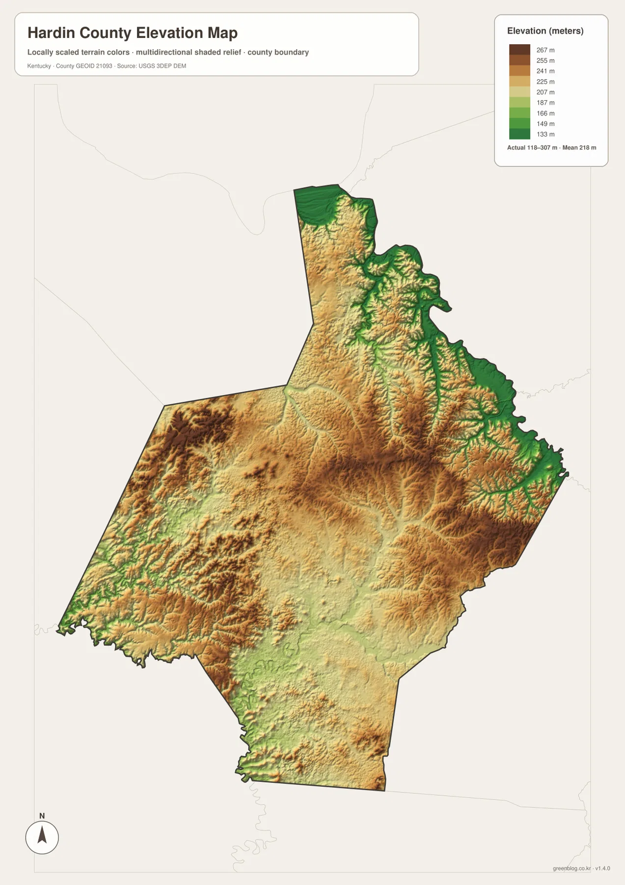
The elevation map reports an actual county range of roughly 118 to 307 meters and a mean of 218 meters. The lowest green terrain follows the Ohio River and other major stream valleys. Deep green lines also appear along narrow drainages on the eastern side, closely matching the stream pattern on the terrain and water map. These low corridors are separated by higher ground that rises quickly on both sides.
Central and western Hardin County contain broad areas of tan and brown upland. The western interior has especially varied relief, with short ridges and hollows packed closely together in places. Around the central developed area, the terrain is still rolling but less sharply dissected than many northeastern valleys. The southern section near Sonora and Upton appears comparatively smoother, although smaller drainage cuts remain visible.
Comparing the elevation and road maps helps explain route geometry. I-65 and U.S. 31W maintain relatively direct north-south paths through much of the county, while smaller roads in the east and west bend more often around valleys and ridges. The elevation surface is generalized for county-scale comparison, so it should not be used as a survey-grade source for construction, parcel elevation, bridge design, or other site-specific engineering decisions.
Fort Knox and Elizabethtown provide two useful anchors for understanding local geography
Hardin County’s official government site identifies Fort Knox as an important part of the county, and its area-cities page highlights Elizabethtown along with Radcliff, Vine Grove, West Point, Sonora, Upton, and other communities. That local description matches the pattern visible on the maps: military land and closely spaced communities dominate the north, while Elizabethtown forms a separate center farther south. The road network between them is one of the county’s defining geographic relationships.
A simple way to orient yourself is to divide the county into three broad reference areas. West Point and Fort Knox define the north; Radcliff, Vine Grove, and Elizabethtown organize the middle; and Sonora and Upton mark the south. After those positions are familiar, smaller places such as Rineyville and Cecilia can be placed within the larger framework. This approach is much easier than starting with route numbers alone.
The county’s tourism information also points visitors toward places such as Freeman Lake Park in Elizabethtown and Saunders Springs Nature Preserve in Radcliff. These attractions add useful real-world context to the mapped settlement pattern, but the county maps are not trail maps or facility guides. Check the current park or local-government page for opening hours, access rules, and detailed visitor information before planning a trip.
Frequently Asked Questions
Where are the largest cities in Hardin County?
The city index places Elizabethtown first and Radcliff second, with Vine Grove also forming part of the northern-central cluster. West Point is separated near the Ohio River, while Sonora and Upton are farther south along the I-65 and U.S. 31W corridor. The map values are useful for relative comparison, but current population estimates should be checked with the Census Bureau.
Can I see Fort Knox and Elizabethtown on the same county map?
Yes. The general map shows Fort Knox in the north together with Radcliff, Vine Grove, and Elizabethtown farther south, so their relative positions and connecting roads are easy to compare. The map is not intended to show detailed military installation access or internal roads, so visitors who need entry information should consult current Fort Knox guidance.
What is the elevation range shown for Hardin County?
The supplied elevation map shows an actual range of about 118 to 307 meters and a mean of 218 meters. Lower terrain follows the Ohio River and major stream valleys, while higher rolling ground occupies much of the interior. For a precise point elevation, use official USGS elevation data or a professional survey rather than the generalized county map.
Map File Information
Download the map files associated with this page for reference, printing, and compatible visual projects.
- Included Files: Use only the versions confirmed in the article and supplied images
- File Type: Use the confirmed download contents
- Intended Use: Printing, education, presentations, and map-based projects
Related Maps
Sources and references
Local context is available from the official Hardin County website, the county’s Area Cities page, and Area Tourism page. Boundary and road references include the U.S. Census Bureau TIGER/Line files and Kentucky Transportation Cabinet printable maps. Water and elevation source data are available from USGS National Hydrography and the USGS 3D Elevation Program.
Green Map creates custom-edited map images using open geographic data sources such as geoBoundaries, Natural Earth, OpenStreetMap, and government open data. These maps are edited visual materials, not raw data files, and are provided for education, documents, presentations, and graphic reference.