Garrard County sits in central Kentucky with Lancaster as its clearest road and settlement reference, while the landscape changes sharply from the low Kentucky River edge in the northwest to higher, tightly cut ridges in the southeast. This page follows the features actually shown on the supplied maps: county boundaries, numbered roads, Lancaster, named creeks, and an elevation range of about 156 to 427 meters. High-resolution JPG versions of all four maps are also available below in one ZIP file for printing, classroom work, and local orientation. High-resolution map files are available for download in the section below.
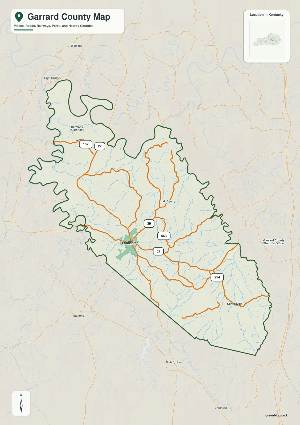
The easiest way to orient yourself is to find Lancaster and U.S. 27 first. Lancaster lies slightly southwest of the county’s visual center, and U.S. 27 runs through it on a north-south line. The northwestern boundary is much more irregular because it follows broad bends of the Kentucky River, while the southern edge includes a long straight segment. Farther southeast, short ridges and narrow valleys become more closely packed, so roads and streams appear increasingly curved and confined.
Table of Contents
Lancaster and U.S. 27 provide the clearest starting point
Lancaster is the most prominent place name on the general county map. U.S. 27 passes through the city, while KY 39 and KY 52 meet the same central area and make it easy to trace routes toward different parts of the county. KY 563 extends east and northeast from the Lancaster area. KY 152 is visible in the northwestern section, and KY 954 crosses the southeastern interior near Cartersville. Instead of a single highway dominating the county, several numbered routes branch from the Lancaster area and follow the valleys through rolling terrain.
Places outside the boundary help place Garrard County in a wider regional setting. Wilmore and High Bridge appear to the northwest, Stanford lies to the southwest, and Crab Orchard is south of the county. The simplified surroundings also show Jessamine County, Madison County, Mercer County, Boyle County, and Lincoln County. Those references are useful because Garrard County’s official website describes the county as being in central Kentucky just south of Lexington, and the map’s surrounding labels make that position easy to visualize.
The city layer makes Lancaster the sole major-city reference
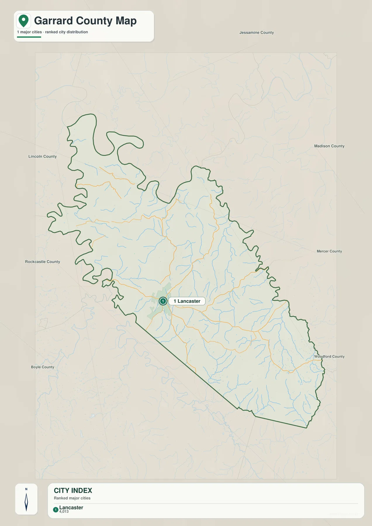
The city-index map lists one major city: Lancaster, with a displayed population of 4,013. There are no hub-to-city distance lines because no second major city is included in this particular layer. That stripped-down view is useful in Garrard County because it emphasizes how strongly Lancaster serves as the principal settlement reference while the rest of the county is represented by smaller communities, rural roads, farms, creeks, and narrow valleys.
Lancaster does not sit at the geometric center of the county. The boundary stretches far northwest along the Kentucky River and extends southeast into a long wedge of more rugged terrain. On the city map, surrounding county names make that shape easier to interpret without the visual clutter of every numbered road. Use this layer when the question is simply where Lancaster lies within Garrard County or how the county sits between Jessamine, Madison, Mercer, Boyle, and Lincoln counties.
Kentucky River bends and Sugar Creek valleys shape the northwest
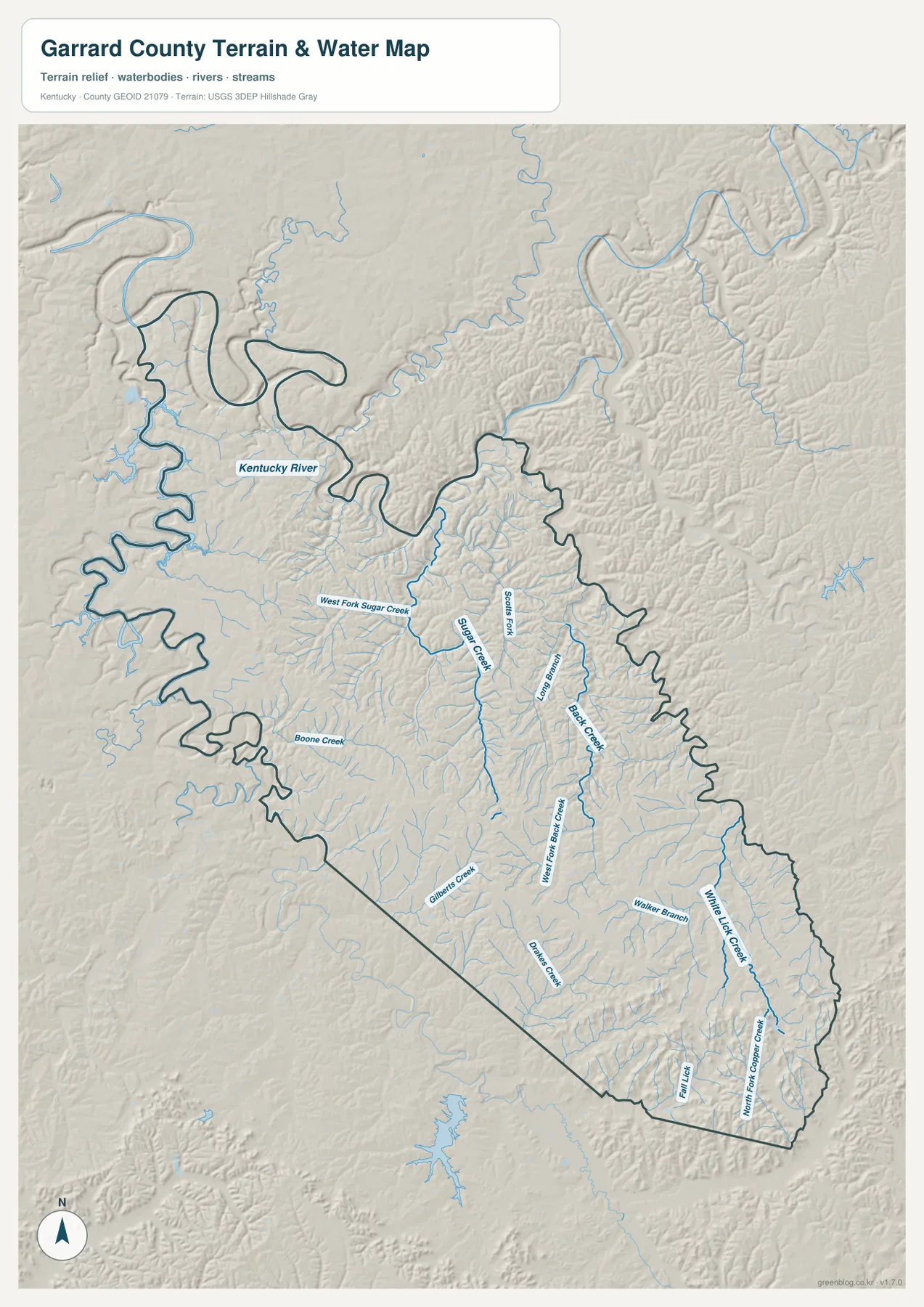
The Kentucky River is the largest water feature on the terrain-and-water map. It follows the northwestern edge in a series of broad bends, creating both a low river corridor and a highly irregular county boundary. Inland, Sugar Creek and West Fork Sugar Creek run through the north-central and northwestern interior, while Scotts Fork lies just to the east. Boone Creek marks part of the western side, and Gilberts Creek provides another named valley farther south.
The eastern and southeastern half contains a denser collection of narrow streams. Paint Lick Creek, Black Creek, White Lick Creek, White Fork Black Creek, Darnell Creek, Walker Branch, Fall Lick, and North Fork Copper Creek are all labeled on the supplied map. Their courses explain why the relief looks finely divided: many ridges are separated by short drainage valleys rather than by one broad flat plain. The road network often bends with or crosses those same valleys, so the water layer adds geographic context that a road-only map cannot show.
Garrard County’s official information highlights the Kentucky River Palisades and Herrington Lake area as part of the county’s natural setting. The supplied water map is still a static geographic reference rather than a flood, navigation, or live stream-stage product. Use it to understand where the named waterways and valley corridors are located, then consult the responsible agencies when current water conditions or flood risk are the actual concern.
A 156–427 m range rises strongly toward the southeast
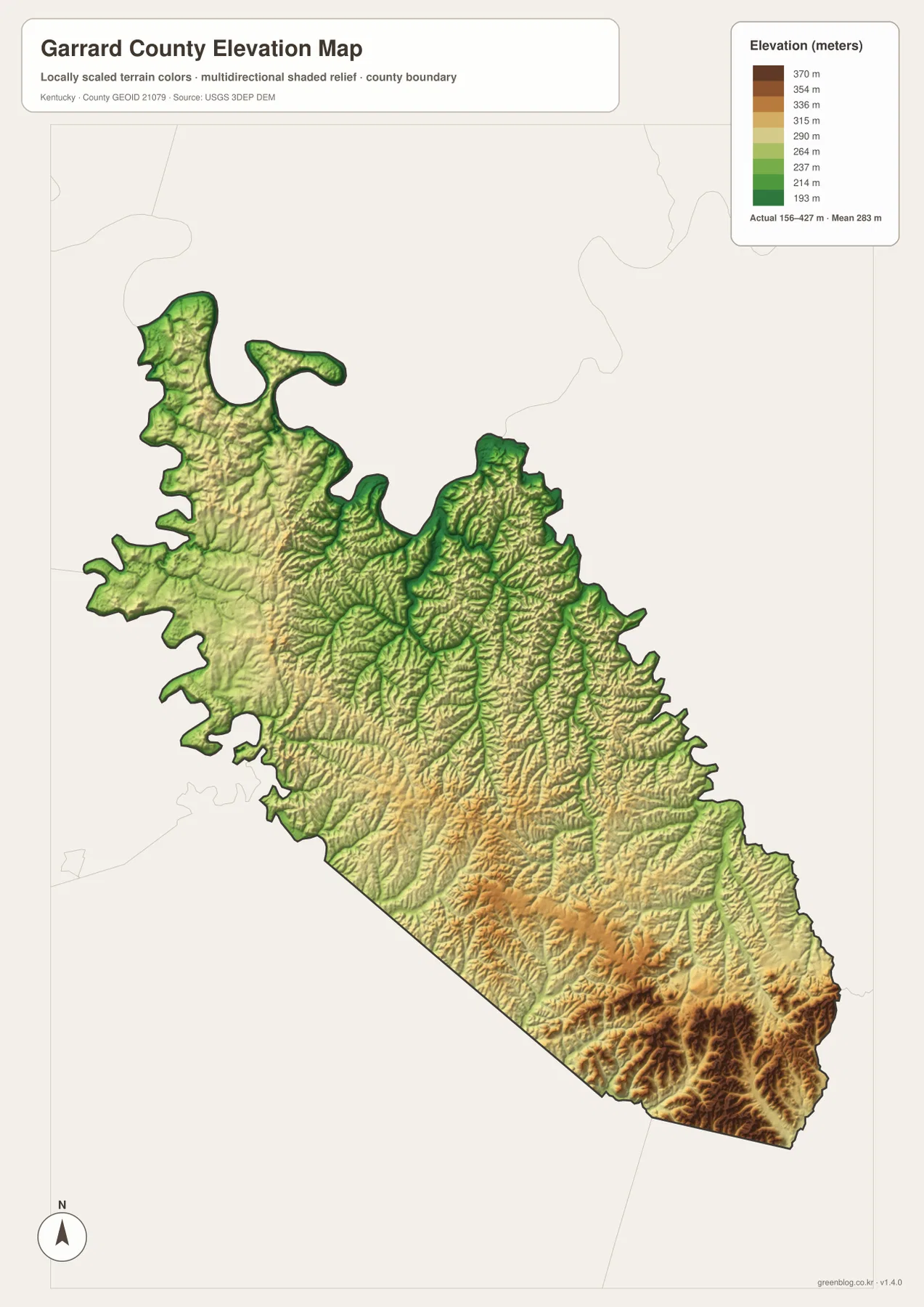
The elevation map reports an actual county range of about 156 to 427 meters and a mean of 283 meters. The lowest green terrain appears along the Kentucky River at the northwestern edge and continues into some of the larger creek valleys. Sugar Creek and nearby drainage corridors form lower paths through the middle of the county, while much of the Lancaster area sits on intermediate rolling ground rather than in the deepest river lowland.
Elevation rises much more clearly toward the southeast. Around Paint Lick Creek and White Lick Creek, narrow low corridors are surrounded by tightly spaced ridges shown in yellow, orange, and brown. The far southeastern corner contains the most concentrated high terrain, with repeated short spurs and valleys. This creates a strong contrast with the broader, lower Kentucky River landscape in the northwest even though both areas are within the same relatively compact county.
The color surface is generalized for county-scale comparison. It is useful for distinguishing low river bottoms, creek valleys, rolling uplands, and higher ridges, but it is not a survey-grade elevation source for a parcel, building, or engineering project. Pairing this map with the water layer is especially helpful because many of the lowest green corridors line up with the named streams.
Different parts of Garrard County call for different map pairings
For Lancaster and nearby communities, start with the city layer and then move to the general county map. The city layer gives a clean visual anchor, while the general map adds U.S. 27 and the state routes needed to trace movement toward McCreary, Cartersville, and smaller surrounding places. This sequence works well when you want to move from a familiar center to a more detailed road location without being distracted by every stream name.
For the Kentucky River edge or the southeastern interior, the water and elevation maps are more informative together. In the northwest, the river bends correspond with the lowest broad terrain. In the southeast, White Lick Creek, Paint Lick Creek, and neighboring tributaries occupy narrow valleys between higher ridges. Comparing the two layers explains why roads in those areas often curve through lower corridors instead of taking a straight path across the county.
Choose the file that matches the question you are answering
The general map is the best choice when you need county boundaries, Lancaster, numbered roads, and nearby place names on one page. Use the city map when Lancaster’s position and the surrounding county context are the main focus. The terrain-and-water map is better for the Kentucky River and named creeks, while the elevation map is the clearest layer for comparing the broad northwestern lowland with the higher southeastern ridges.
The downloadable ZIP contains the high-resolution JPG originals, which are more suitable than the web previews for larger prints and classroom material. The four maps are designed to complement one another: road and place locations are easiest on the general map, drainage is clearest on the water layer, and the elevation map adds the vertical difference between valleys and ridges.
Frequently Asked Questions
Where is Lancaster on the Garrard County map?
Lancaster is slightly southwest of the county’s visual center and is the clearest road reference on the general map. U.S. 27 passes through the city, while KY 39 and KY 52 also meet the Lancaster area. On the simplified city map, Lancaster is the only ranked major city shown.
Which part of Garrard County is lowest on the elevation map?
The lowest terrain is concentrated along the Kentucky River at the northwestern edge and in several connected creek valleys. The map reports an actual range of about 156 to 427 meters with a mean of 283 meters. Higher and more closely spaced ridges become much more common toward the southeast.
Which map is best for finding Sugar Creek or Paint Lick Creek?
Use the terrain-and-water map when a named stream is the main target. Sugar Creek and West Fork Sugar Creek are labeled in the north-central part of the county, while Paint Lick Creek and White Lick Creek are clearer in the eastern and southeastern interior. For live water levels or flood risk, use current official services rather than this static map.
Map File Information
Download high-resolution JPG originals for Garrard County's general, city, terrain-and-water, and elevation maps in one ZIP file.
- Included Files: county map, city map, terrain-and-water map, elevation map
Related Maps
Sources and references
Local context is available from the official Garrard County website and its About Garrard County page. State road and printable-map references can be checked through the Kentucky Transportation Cabinet.
Administrative boundaries are supported by the U.S. Census Bureau TIGER/Line program. Hydrography references come from USGS National Hydrography, and elevation references come from the USGS 3D Elevation Program. These maps are static references; legal boundaries, parcel questions, flood risk, live road conditions, and engineering work require current data from the responsible agency.
Green Map creates custom-edited map images using open geographic data sources such as geoBoundaries, Natural Earth, OpenStreetMap, and government open data. These maps are edited visual materials, not raw data files, and are provided for education, documents, presentations, and graphic reference.