Cumberland County in southern Kentucky is easiest to understand from Burkesville outward. The town sits near the Cumberland River, where broad river bends are surrounded by short ridges and narrow stream valleys. Roads such as KY 90 and KY 61 leave Burkesville in different directions, while smaller routes turn through the broken terrain toward places such as Marrowbone, Amandaville, and Ashlock. The county therefore makes more sense as a network of valleys and river crossings than as a simple outline on a state map.
The page is designed for both quick viewing and file use. The on-page WebP images are convenient for browsing, while the download box near the end provides the larger JPG originals in one ZIP for printing or close label inspection. These maps are county-scale reference graphics rather than live navigation, surveying, flood determination, or legal boundary products, so current agency information should be used whenever a decision depends on present conditions.
Table of Contents
Burkesville is the practical starting point for roads and local orientation
Burkesville stands out immediately because several numbered roads converge around it. KY 90 leaves the town toward the east, KY 61 continues south, and routes including KY 449, KY 485, and KY 704 connect nearby valleys and uplands. Farther northeast, KY 912 appears near Amandaville, while KY 379 is visible toward the eastern county line. The routes rarely stay straight for long; the repeated bends are a useful reminder that the road network has to work around streams, ridges, and narrow passes through the terrain.
Marrowbone gives the western side of the county a second reference point. KY 100 and KY 496 appear nearby, and KY 691 and KY 214 extend through the southwestern part of the county. Ashlock, close to the southern boundary, helps show how KY 61 carries the main north-south connection away from Burkesville. Seeing the place names together with the road numbers is more informative than following the county boundary alone because it reveals how local travel is organized around a few valley corridors.
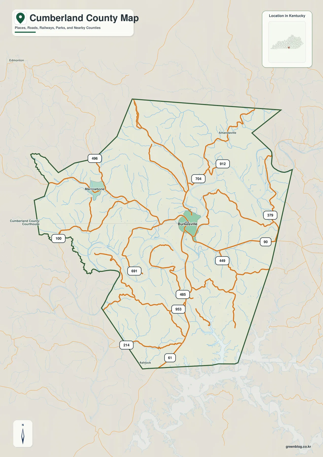
The outer boundary is irregular as well. Several western and southwestern sections project outward, and the eastern side changes direction repeatedly rather than forming a clean rectangle. Those shapes are easier to place when the surrounding counties are considered at the same time. Cumberland County sits among Adair, Metcalfe, Monroe, Clinton, and Russell counties, which gives the boundary context that a standalone outline does not provide.
For local orientation, this road-and-place view is the most useful starting image. It contains enough detail to locate the smaller named communities and trace county routes without requiring the viewer to interpret elevation colors first. Anyone planning an actual trip should still use current transportation information, because closures, construction, and temporary detours are outside the scope of a static county map.
The Cumberland River bends turn a complicated road pattern into a readable landscape
The Cumberland River is the county’s strongest natural guide. It passes the Burkesville area, sweeps west in a broad bend, and curves again toward the southwest. Once the river is used as a reference, many road turns become easier to interpret. Some routes stay on lower ground close to the river or its tributaries, while others swing around ridges before reaching another valley. The relationship between roads and water is especially noticeable in a county where short ridges repeatedly interrupt direct east-west or north-south travel.
A simplified location view is useful when the question is not “which local road?” but “where is Burkesville within southern Kentucky?” With small road labels removed, Burkesville remains the dominant point and the neighboring counties provide a clean regional frame. This is helpful for a presentation, classroom handout, or article illustration where too much local detail would distract from the county’s location.
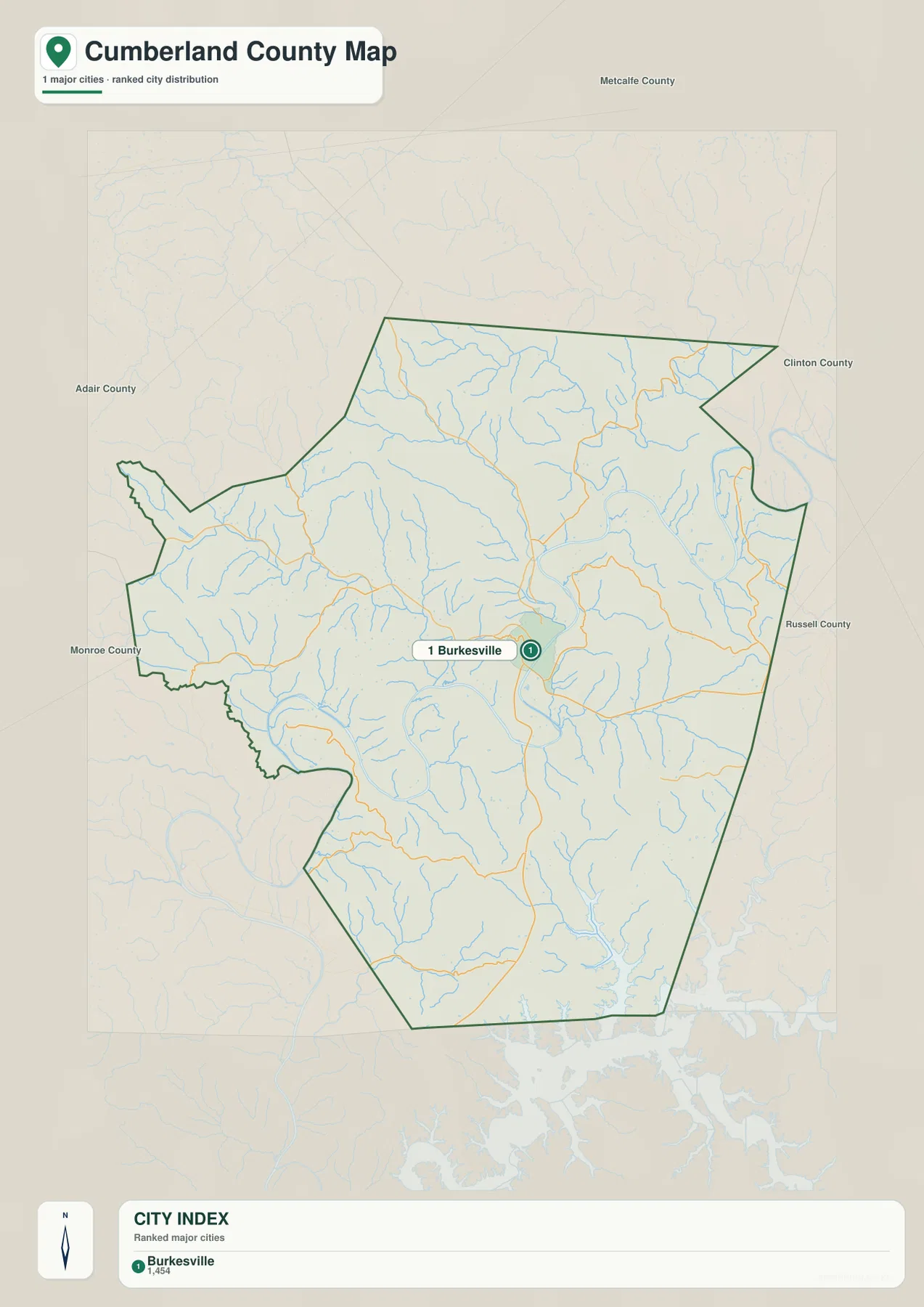
The simplified view also highlights how uneven the county shape is. Burkesville may appear close to the middle, yet the boundary stretches into irregular western and southern sections. Those extensions become more meaningful when compared with the river and terrain graphics: they contain narrow valleys, short ridges, and routes that do not fit a regular grid. For that reason, the simple view works best for regional placement, while the detailed road map is better when a smaller community or a specific state route matters.
County information published by Cumberland County itself also centers local government and community services in Burkesville. That official context matches what the maps suggest visually: Burkesville is the county’s clearest reference point, but the surrounding landscape remains strongly rural and terrain-driven. The map should not be treated as a substitute for current road notices or official property information.
North-country creeks feed the Cumberland while the southern landscape opens toward Dale Hollow Lake
The northern half of the county is crossed by several narrow tributary systems. Crocus Creek and West Fork Crocus Creek are easy to pick out, while Big Renox Creek and Little Renox Creek occupy nearby valleys. Marrowbone Creek provides another western reference, and Mud Camp Creek appears farther southwest. Their branching pattern fits the terrain: rather than crossing broad level ground, the streams occupy low corridors between compact ridges and eventually connect with larger drainage routes.
Closer to the central and eastern parts of the county, White Creek, White Branch, Cedar Creek, Carter Branch, and Bear Creek add more detail to the drainage pattern. These names help distinguish one valley from another when the relief shading alone starts to look repetitive. The Cumberland River remains the main organizing waterway, but the smaller creeks explain why the local landscape is divided into so many short slopes and narrow hollows.
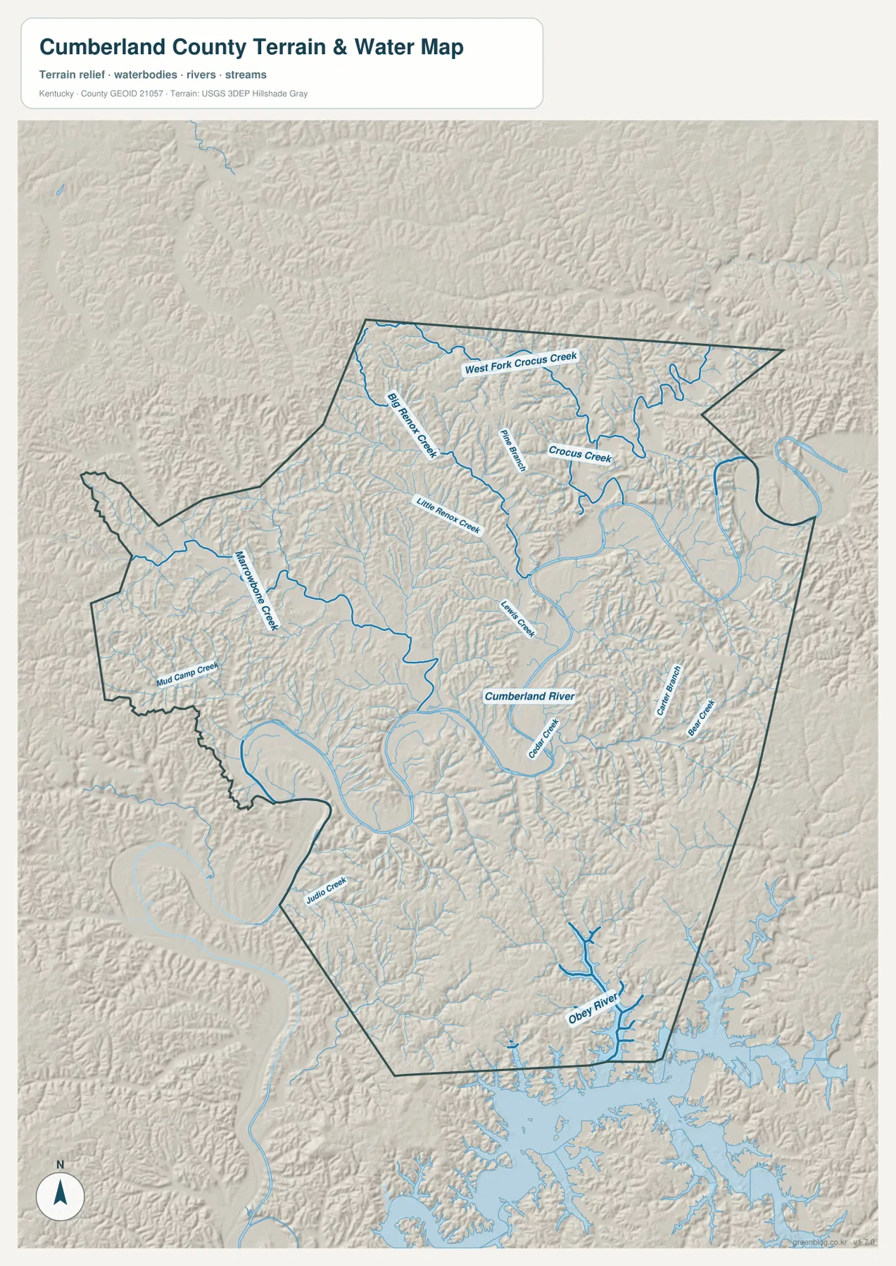
The southern edge has a different visual character because the Obey River and Dale Hollow Lake occupy a much larger area than the small northern creeks. The reservoir reaches into branching valleys, producing a long, irregular shoreline rather than one broad open basin. Kentucky State Parks identifies Dale Hollow Lake State Resort Park with a Burkesville address, underscoring how closely the lake area is tied to the county even though the reservoir extends beyond one local valley.
This water view is useful for locating named streams and understanding how they fit between ridges, but it does not report present water level, flood stage, boating conditions, or access restrictions. Those conditions can change quickly. For recreation or safety decisions, use the map for orientation and then check the responsible agency for current lake, river, and access information.
A 158–344 meter range separates the river corridors from higher ridge groups
Elevation in the supplied county map ranges from about 158 to 344 meters, with a mean near 234 meters. The lower colors cluster along the Cumberland River and larger tributary valleys, while higher yellow and brown areas occupy many of the ridges between them. A difference of roughly 186 meters between the mapped low and high values is enough to create repeated transitions from valley floor to slope and ridge across a relatively small area.
Higher ground appears in several northwestern and northern groups. Big Renox Creek and the Crocus Creek system cut lower paths between those uplands, making the relationship between drainage and relief particularly easy to see. Another set of higher ridges appears in the southeast, although the entire southern side is not uniformly high because the Obey River, Dale Hollow Lake, and smaller tributaries occupy lower corridors there as well.
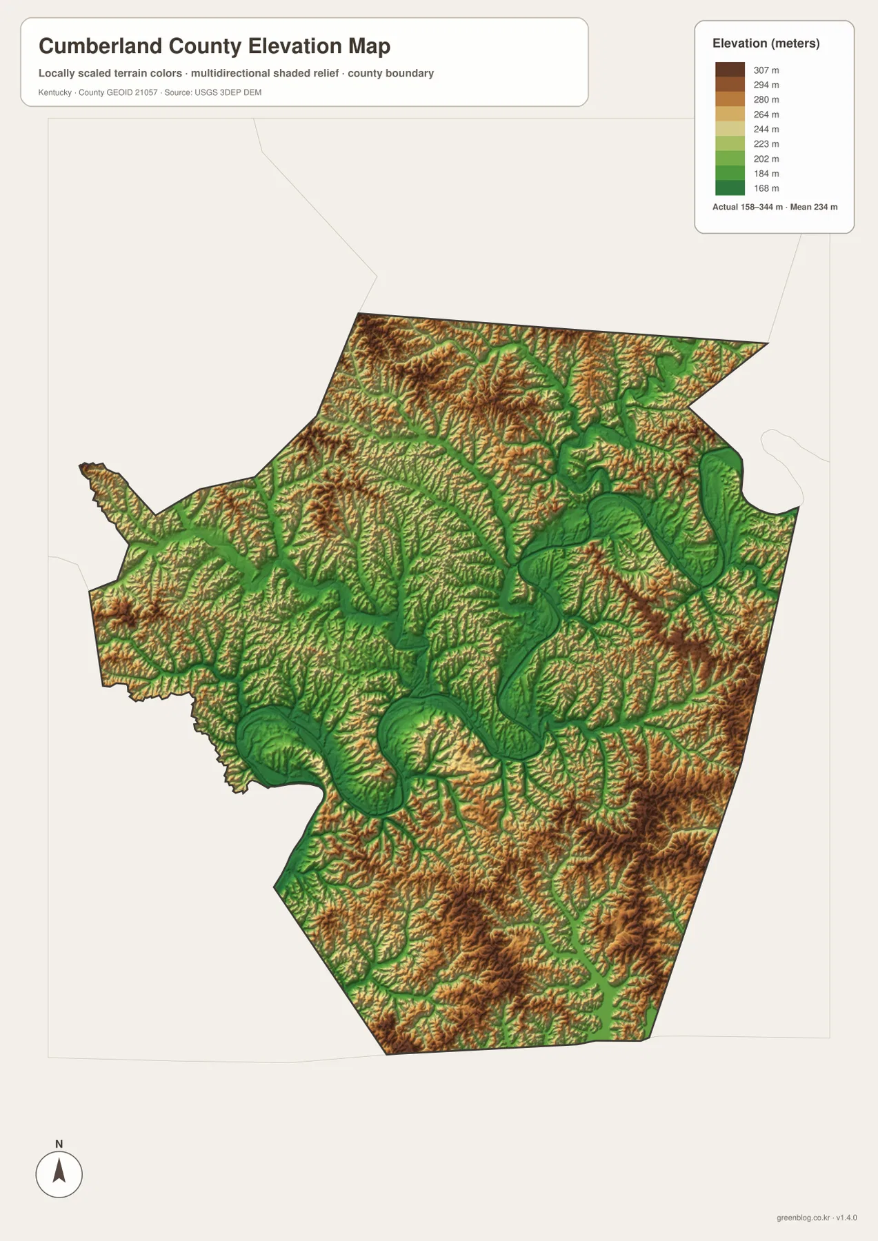
Burkesville itself sits close to a lower corridor associated with the Cumberland River. Ridges rise nearby, but the river valley creates a broader opening where several roads can come together. That geographic relationship helps explain the town’s strong central role on the road map. It should not be stretched into claims about parcel suitability, drainage at a specific property, or construction conditions, which require much more detailed information.
Comparing road lines with the elevation colors also clarifies why many routes bend. Roads often remain in lower valleys for a distance and then change direction where a ridge narrows the corridor or where another drainage route provides an easier passage. The elevation map is excellent for county-scale comparison, but exact heights for a bridge, building site, or property boundary should come from USGS 3D Elevation Program data, engineering records, or a professional survey.
Choose the file that matches the question instead of trying to use one map for everything
If the question is about Burkesville, Marrowbone, Amandaville, Ashlock, or specific routes such as KY 90 and KY 61, start with the detailed road-and-boundary view. For a clean regional graphic, the simplified Burkesville view removes most local clutter. Water questions are better answered by the terrain-and-stream graphic because the Cumberland River, Obey River, Crocus Creek, Renox creeks, and other tributaries are labeled in the same view as the surrounding relief.
For relief, the elevation colors provide the fastest comparison. The 158–344 meter range becomes more useful when the lower greens are matched to named river valleys and the higher browns are matched to ridge groups. In a presentation or printed handout, selecting the single map that best matches the topic usually reads more clearly than placing every layer on the same page. For a detailed county explanation, switching among the maps makes the road-water-terrain relationship easier to follow.
The downloadable archive contains the high-resolution JPG originals corresponding to the maps used on this page. Each image is 3638 × 2572 pixels, giving more room for printed labels and close inspection than the smaller WebP display files. They work well for personal reference, lessons, presentations, and regional orientation, while legal, emergency, engineering, and live travel decisions should always rely on current authoritative sources.
Frequently Asked Questions
What should I follow first when tracing Burkesville toward Dale Hollow Lake?
Locate Burkesville and KY 61 first, then compare that southward direction with the Obey River and Dale Hollow Lake area. The road view is best for orientation, while the terrain-and-water view shows how the reservoir branches into narrow valleys. Use current navigation and transportation sources for an actual driving route or road closure information.
Where is the contrast between low river valleys and higher ridges easiest to see?
The elevation map makes the contrast most direct. Lower colors follow much of the Cumberland River and its larger tributary corridors, while higher colors appear on ridge groups between them. The mapped county range is about 158–344 meters with a mean near 234 meters.
How are the downloaded files different from the images displayed in the article?
The ZIP contains 3638 × 2572 pixel JPG originals, which are larger than the WebP files used for normal page display. The extra resolution is useful for printing and for zooming in on road numbers, small place names, stream labels, and elevation colors.
Map File Information
The Cumberland County source maps used on this page are bundled as high-resolution JPG files. The larger originals are better for printing and close inspection of route numbers, creek names, and elevation colors than the WebP images shown in the article.
- Included Files: county map, city map, terrain and water map, elevation map
- File Type: JPG
Related Maps
Sources and references
For local background, use the official Cumberland County website and its About Cumberland County page. Official visitor information for the southern lake area is available from Kentucky State Parks. Boundary data can be checked through U.S. Census Bureau TIGER/Line Shapefiles, hydrography through USGS National Hydrography, and terrain data through the USGS 3D Elevation Program.
Green Map creates custom-edited map images using open geographic data sources such as geoBoundaries, Natural Earth, OpenStreetMap, and government open data. These maps are edited visual materials, not raw data files, and are provided for education, documents, presentations, and graphic reference.