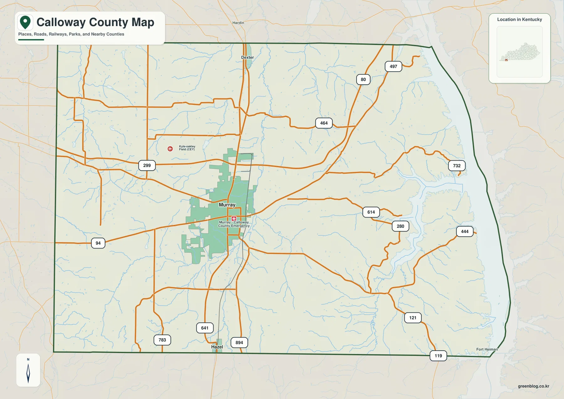
Calloway County sits in far western Kentucky, where Murray provides the clearest urban reference point and Kentucky Lake defines much of the county’s eastern side. U.S. 641 runs north-south through Murray toward Hazel near the Tennessee line, while KY 94 and other state routes spread east and west across the interior. The county is easy to understand once those three anchors are located: Murray near the south-central interior, Hazel near the southern edge, and the broad lake shoreline to the east. High-resolution map files are available for download in the section below.
The maps on this page can be viewed online and downloaded as high-resolution A3 JPG files for print or reference use. The county map is best for roads and place names, the city map reduces the view to the main incorporated places, the water map highlights Clarks River, Blood River, Jonathan Creek, and Kentucky Lake, and the elevation map compares terrain across a 107–194 meter range. These are general geographic reference maps rather than parcel, flood-hazard, live-navigation, or engineering products.
Table of Contents
Murray gives the road network an easy starting point
Murray is the most useful place to start when reading the county map. It lies a little south of the geographic center and is crossed by U.S. 641, which continues south toward Hazel and north toward the upper part of the county. KY 94 provides an important east-west reference through the Murray area, while KY 80 is visible farther north and northeast. Together, these routes make Murray a practical orientation point even for readers who have never seen Calloway County before.
The road pattern changes as the eye moves away from Murray. Western roads tend to be easier to follow across the interior, while roads approaching Kentucky Lake turn more often around creeks, coves, and uneven ground. The southern county line along Tennessee is comparatively straight, but the eastern boundary bends repeatedly with the lake shoreline. Kyle-Oakley Field is also marked northwest of Murray, giving another recognizable reference for the relationship between the city center and nearby transportation features.
The city map strips away most of the smaller road detail and makes the relationship between Murray and Hazel easier to see. Murray sits in the south-central interior, while Hazel is farther south close to the Tennessee state line. The surrounding labels also show Marshall County to the north, Graves County to the west, and Trigg County to the east, which helps place Calloway County within the broader western Kentucky region without requiring a separate statewide map.
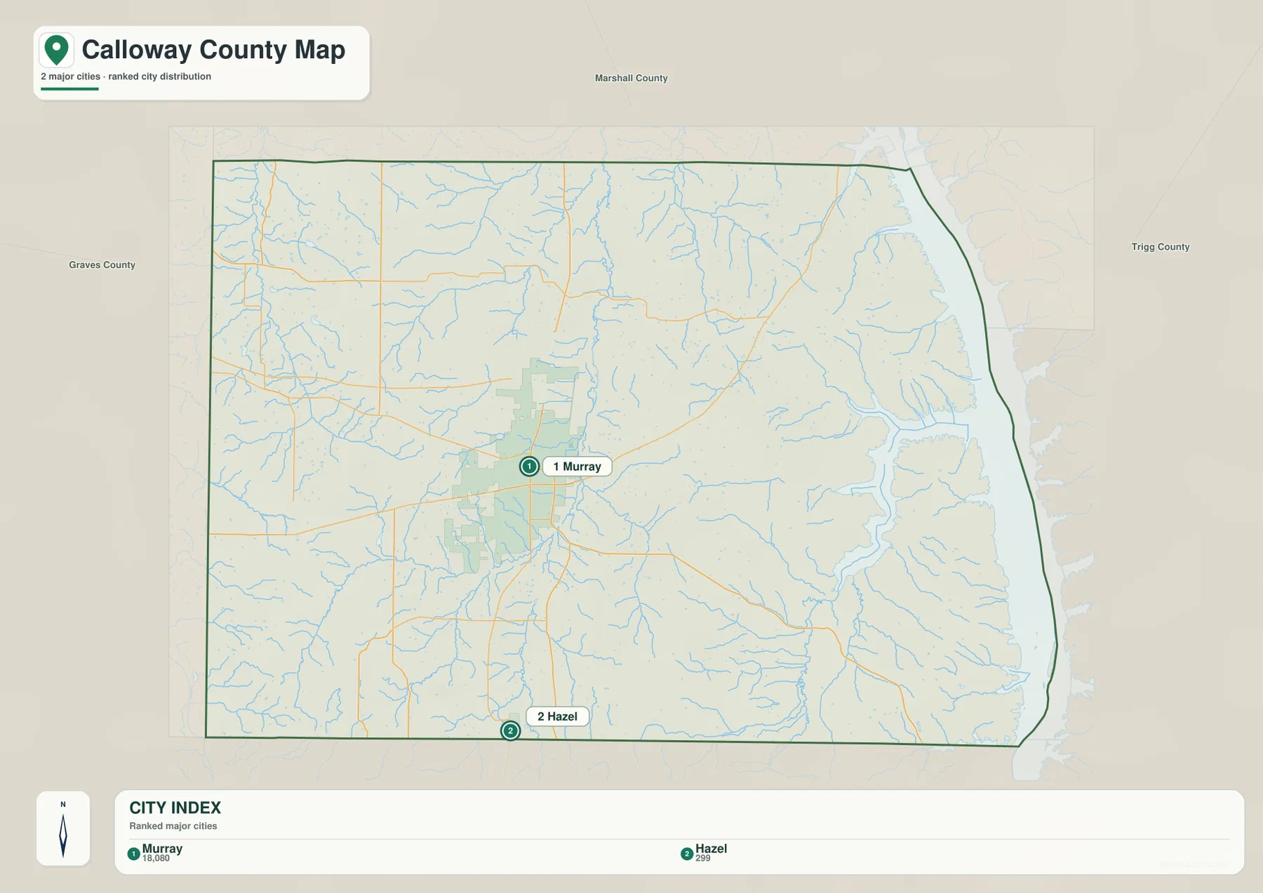
Murray and Hazel serve different purposes when orienting a reader. Murray is the central place for understanding the county’s roads and settlement pattern, whereas Hazel marks the southern end of the county and the approach to Tennessee. Once those two places are connected mentally by U.S. 641, Kentucky Lake provides the third major direction. This simple framework is often more useful than beginning with a long list of smaller roads or minor place names.
Clarks River and Blood River divide the county into distinct water landscapes
The water map makes the central Clarks River system easy to identify. Clarks River runs through the middle of the county, while West Fork Clarks River forms another prominent drainage farther west. East Fork Clarks River appears toward the southern portion of the system. In the northwest, West Fork Rockhouse Creek and East Fork Rockhouse Creek add smaller named channels, so the western half of the county is defined more by streams and valleys than by one large body of water.
The eastern side looks very different. Blood River occupies the southeast and trends toward the broad Kentucky Lake margin, while Jonathan Creek provides another recognizable valley farther north. The shoreline itself is highly irregular, with coves and creek mouths creating a boundary that bends repeatedly. That contrast is one of the most useful things the water map reveals: the center and west are crossed by river valleys, while the east opens into the much larger lake system.
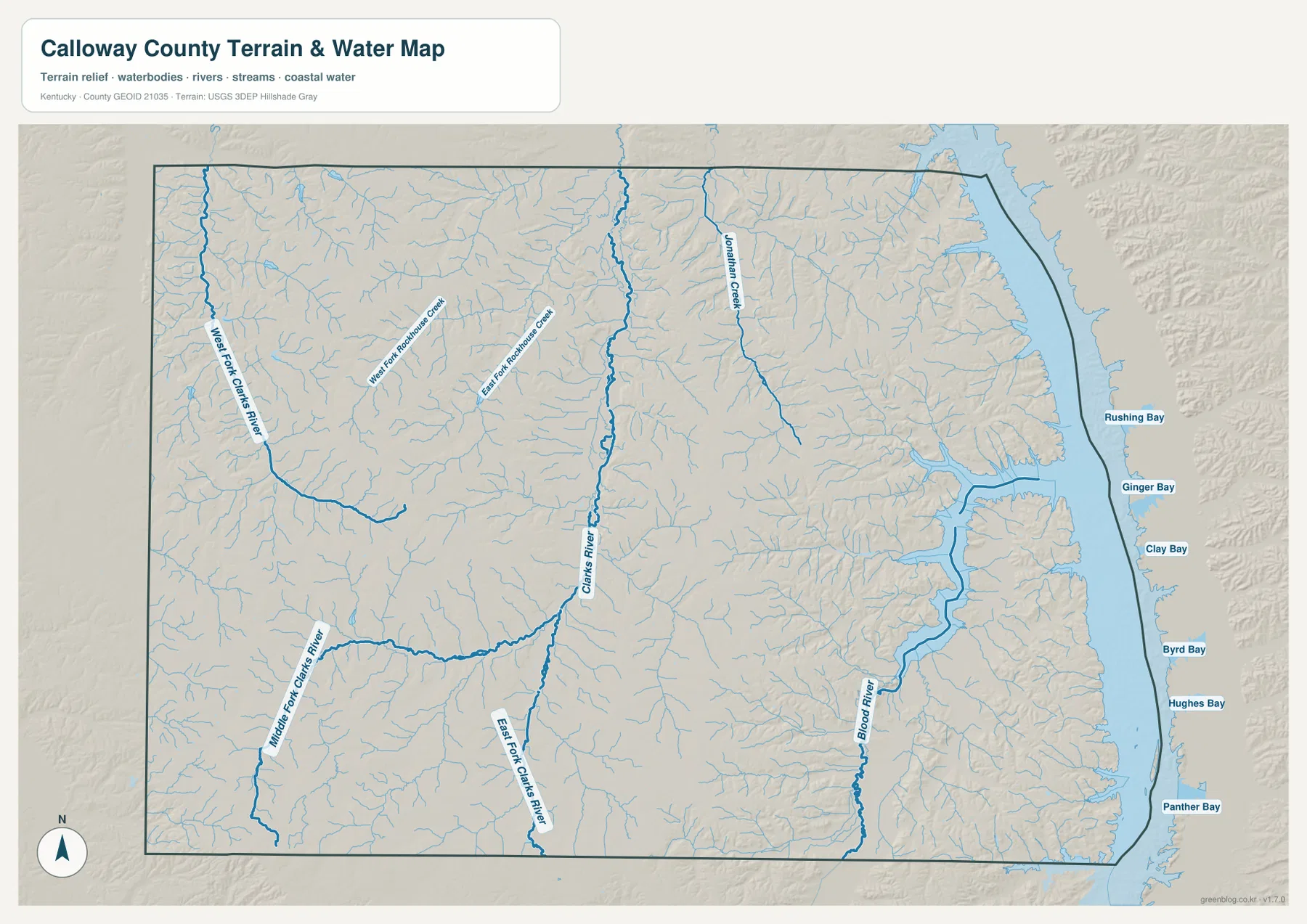
Comparing the water layer with the county road map also explains why some routes are less direct than they first appear. Roads must cross or skirt river valleys, and the eastern road network becomes increasingly fragmented as it approaches Blood River and the lake shoreline. The maps do not imply that every curve is caused by a stream, but they provide enough context to see how valleys and water bodies shape the broad layout of local travel.
This water map is intended for geographic orientation. It does not identify flood zones, current river stages, water quality, navigable channels, fishing rules, or public access to individual shorelines. Anyone making a safety, boating, property, or regulatory decision should use current agency information. For formal hydrography and named-water features, the USGS National Hydrography program is an appropriate source to consult alongside this map.
Kentucky Lake turns the eastern edge into the county’s most irregular boundary
Calloway County’s eastern outline is much more complicated than its southern state line. Kentucky Lake stretches north-south beside the county and creates a sequence of broad curves, narrow inlets, and creek mouths. On the general county map, the edge looks noticeably more irregular than the boundaries to the west or south. On the water map, the reason becomes obvious because the lake occupies a wide swath immediately beyond the county interior.
The lake also changes how the eastern road network appears. Routes leaving Murray toward the east divide into smaller branches, and several roads bend around stream valleys before reaching communities and lake approaches. Blood River and Jonathan Creek help explain part of that pattern. Reading the road and water maps together is therefore more informative than treating Kentucky Lake as a simple blue area at the edge of the page.
For this article, Kentucky Lake is primarily a geographic reference rather than a recreation guide. The maps are useful for showing where the lake sits in relation to Murray, Hazel, Blood River, and the county boundary, but they do not establish legal shoreline limits, marina access, boat routes, or current water conditions. Those details belong to specialized and frequently updated sources.
A 107–194 meter range separates western uplands from lower valleys
The elevation map spans roughly 107 to 194 meters, with an average near 151 meters. Calloway County is not mountainous, yet the terrain is far from uniformly flat. Broad areas of higher ground appear in the west and southwest, while a lower north-south corridor follows the central Clarks River valley. Lower colors also become more common toward Blood River and Kentucky Lake in the east, although narrow ridges remain between the many small valleys.
The central low corridor makes the strongest sense when the elevation and water maps are compared side by side. It follows the same general direction as Clarks River, and another lower passage is visible around West Fork Clarks River farther west. Between the two are higher rolling areas. The eastern side is more finely divided because Blood River and smaller tributaries cut through the uplands, producing a repeated pattern of narrow ridges and lower stream valleys.
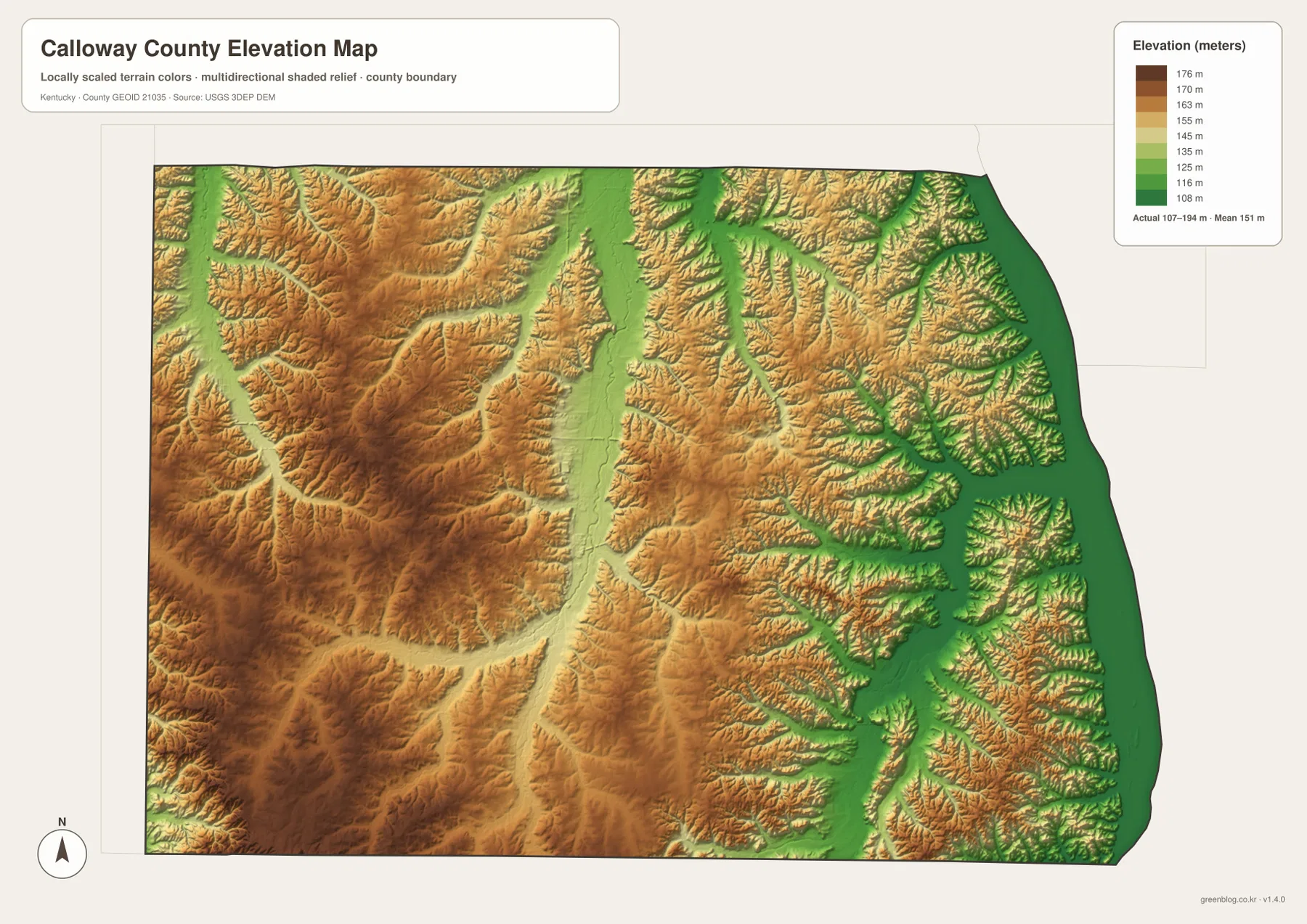
The southern part of the county is not a single level surface either. Higher ground remains west of Hazel, while lower valleys become more evident toward Blood River in the southeast. For that reason, it is more accurate to describe the county as a mix of western uplands, central river valleys, eastern lowlands, and many smaller ridges rather than simply saying that west is high and east is low. The full elevation view preserves those local variations.
Elevation colors are intended for county-scale comparison, not site-specific measurement. They are useful for recognizing the broad relationship among Murray, the Clarks River valley, western uplands, and lower lake country. They should not be used to determine the precise elevation of a building site, road grade, drainage design, or legal survey point. Those tasks require detailed elevation data or field measurements.
Choosing the right map for Murray, waterways, and terrain
For a first look at Calloway County, begin with Murray and U.S. 641, then move south to Hazel and east to Kentucky Lake. That sequence establishes the center, southern edge, and eastern side of the county quickly. The general county map is the best choice when road numbers and route connections matter. If the goal is simply to compare the two incorporated places, the city map removes most of the extra detail and makes Murray and Hazel stand out.
For a water-focused project, use Clarks River as the central reference and compare it with West Fork Clarks River and Blood River. Jonathan Creek and the Rockhouse Creek branches add useful local detail without changing the overall picture. When the subject shifts to Kentucky Lake, pairing the water and elevation maps is especially useful because many of the lower valleys point toward the same eastern lake margin.
Print projects are usually clearer when a single map is selected for the main question rather than layering every feature into one figure. Use the county map for roads and boundaries, the city map for Murray and Hazel, the water map for rivers and Kentucky Lake, and the elevation map for relief. Because all four files use the same county extent, readers can move between them without losing their geographic reference.
For additional administrative or historical context, readers can consult the official Calloway County Fiscal Court website and the City of Murray’s local history material. This page focuses on the geography visible in the supplied maps rather than trying to reproduce changing visitor, event, or service information. Current road work, public access, agency rules, and facility details should always be checked with the responsible organization.
Frequently Asked Questions
Where are Murray and Hazel within Calloway County?
Murray sits a little south of the county’s center and is the main road and settlement reference on the maps. Hazel is farther south, close to the Tennessee state line. U.S. 641 provides the simplest north-south connection for understanding their relative positions.
How do Clarks River and Blood River differ on the map?
Clarks River runs through the central part of the county and forms a long low valley, while Blood River occupies the southeast and trends toward Kentucky Lake. West Fork Clarks River adds another major valley in the west, so the three rivers provide useful reference lines for comparing different parts of the county.
Can the 107–194 meter elevation map be used for construction or surveying?
No. The elevation map is designed for county-scale comparison of higher uplands and lower river valleys. Precise site elevations, road grades, drainage design, engineering, and legal surveying require more detailed official elevation data and, when appropriate, field measurements.
Map File Information
The Calloway County maps used on this page are available as high-resolution A3 JPG files. Each 3638 × 2572px image provides more detail than the web preview for printed handouts, classroom materials, presentations, and local reference documents.
- Included Files: county map, city map, water map, elevation map
- File Type: JPG
Related Maps
Sources and references
Administrative and local background information is available from the Calloway County Fiscal Court and the City of Murray history of Murray and Calloway County. Boundary data can be checked through the U.S. Census Bureau TIGER/Line program, hydrography through USGS National Hydrography, and elevation information through the USGS 3D Elevation Program.
Green Map creates custom-edited map images using open geographic data sources such as geoBoundaries, Natural Earth, OpenStreetMap, and government open data. These maps are edited visual materials, not raw data files, and are provided for education, documents, presentations, and graphic reference.