Phillips County lies along the Nebraska state line in northern Kansas, with Phillipsburg serving as the strongest town and road reference. US 36 crosses the western-central part of the county, US 183 runs south from the Phillipsburg area, and US 383 reaches the northwestern corner near Long Island. Farther south, the North Fork Solomon River forms a long valley that ends in the broad waters of Kirwin Reservoir. High-resolution map files are available for download in the section below.
This guide follows Phillipsburg, Logan, Agra, Prairie View, Long Island, and Kirwin across the supplied maps. Elevation ranges from roughly 503 to 710 meters. WebP previews are available for quick viewing, and the matching high-resolution JPG files can be downloaded together in one ZIP for printing, classroom projects, or offline reference.
Table of Contents
Phillipsburg anchors the road network around US 36 and US 183
Phillipsburg sits slightly south of the county’s center and provides the clearest road reference. US 36 approaches across the western part of the county, while US 183 continues south from the city toward the North Fork Solomon River corridor. US 383 serves the northwestern corner around Long Island and the Nebraska border.
The other towns occupy separate rural settings. Logan is in the southwest, Agra is east of Phillipsburg, Prairie View lies along the western US 36 side, and Kirwin is in the southeast near K-9 and the reservoir country. Long distances of farmland, local roads, and creek valleys separate the communities.
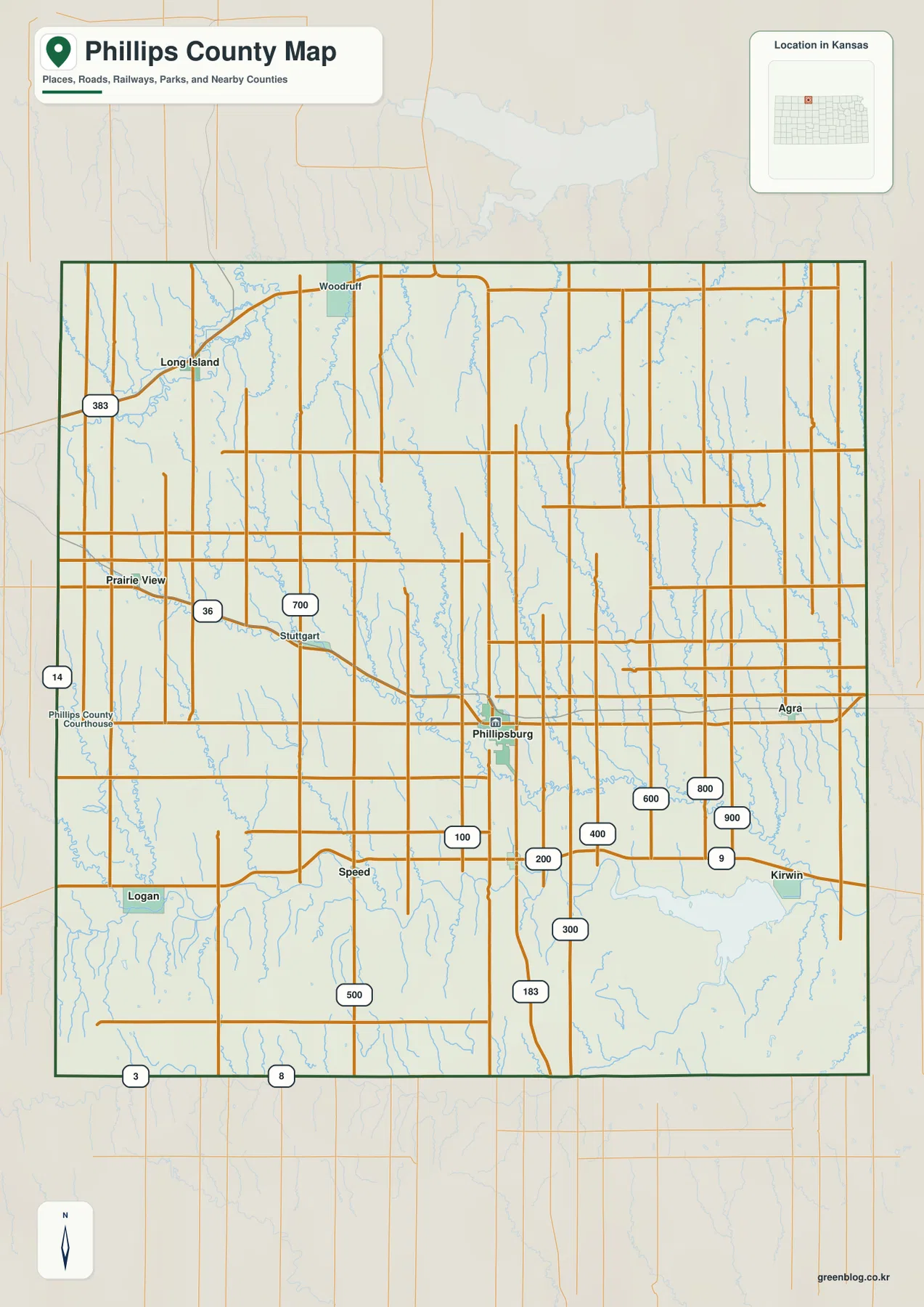
Phillips County’s official history page describes the county as a roughly 30-by-30-mile square bordered by the Nebraska state line to the north, Norton County to the west, Rooks County to the south, and Smith County to the east. It also records the county’s creation in 1867 and Phillipsburg’s development as the county seat.
Phillipsburg dominates the supplied city index
The city panel ranks Phillipsburg at 2,130, followed by Logan at 598, Agra at 244, Prairie View at 156, Long Island at 136, and Kirwin at 63. These are map index values rather than current official population estimates, but they explain the relative size of the city markers on the supplied map.
The geographic pattern matters as much as the ranking. Phillipsburg occupies the central service area, Logan sits southwest near the North Fork Solomon River corridor, and Agra lies to the east. Long Island is close to the Nebraska line in the northwest, while Kirwin is tied closely to the reservoir and wildlife-refuge landscape in the southeast.
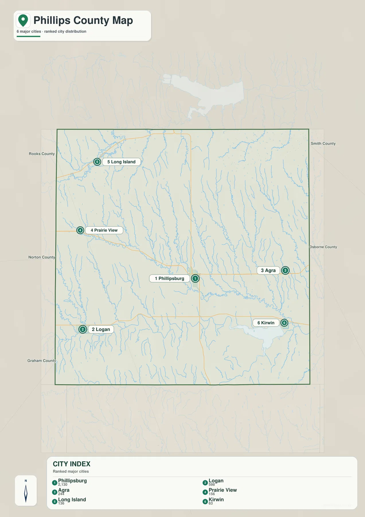
The official Phillips County local-cities page also lists these communities separately and identifies Phillipsburg as the largest local city. That administrative context matches the map, where Phillipsburg stands out as the principal settlement among much smaller surrounding towns.
The North Fork Solomon River defines the southern half of the county
The North Fork Solomon River is the strongest water feature on the terrain-and-water map. It enters from the Logan side, winds eastward through a broad low valley, and expands into Kirwin Reservoir near the southeastern part of the county. The river corridor is noticeably wider and lower than the smaller creek valleys farther north.
Northern Phillips County is divided by a dense network of tributaries. Prairie Dog Creek cuts through the northwest, Battle Creek and Plotner Creek occupy the country around Phillipsburg, and Spring Creek descends farther east. West Plum Creek, West Cedar Creek, and Deer Creek add more parallel valleys on the eastern side.
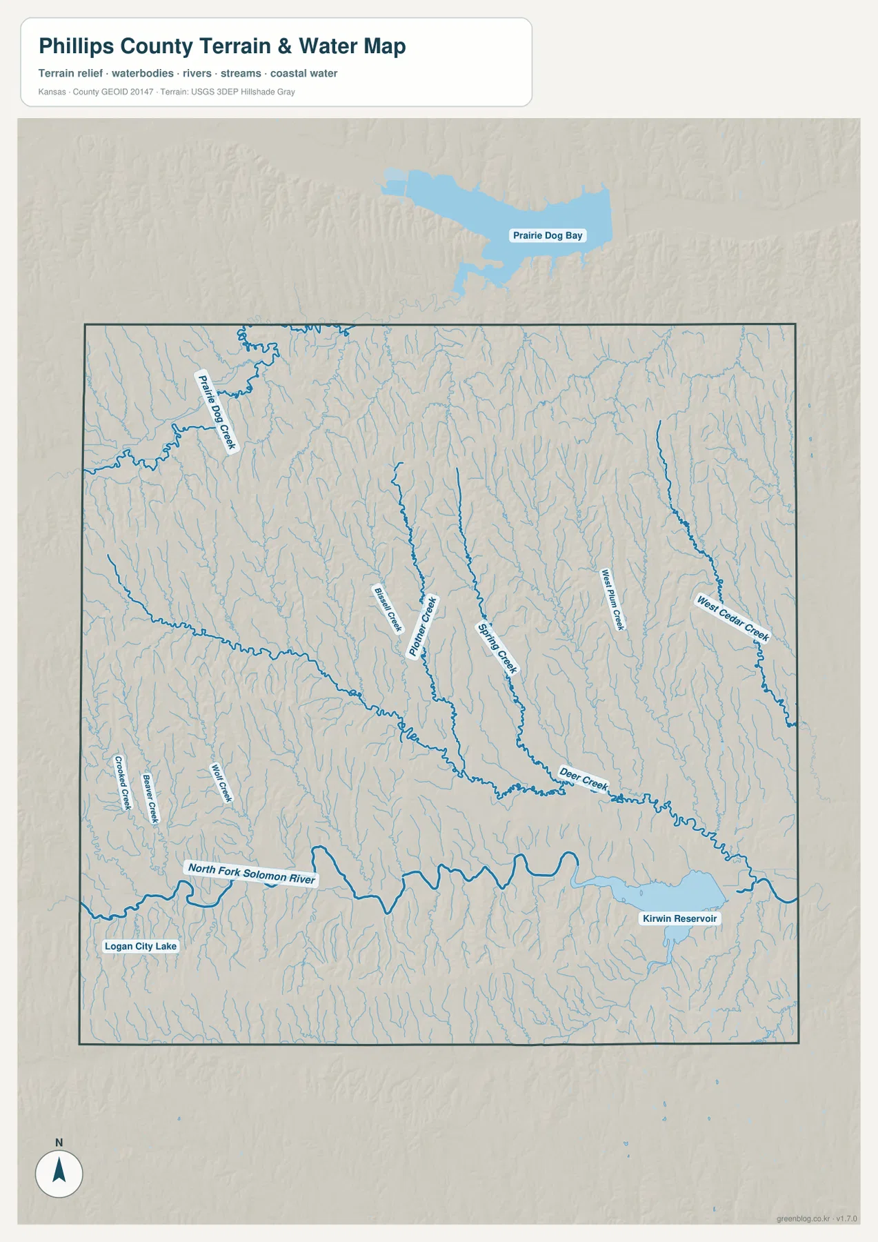
Logan City Lake appears near the southwestern town of Logan, while Kirwin Reservoir is much larger and occupies a major low basin in the southeast. The reservoir is also part of a broader protected landscape associated with Kirwin National Wildlife Refuge.
This water image is intended for geographic reference rather than floodplain, navigation, water-quality, parcel, or legal-access decisions. Water level and boating conditions can change, so current agency information should be used whenever access or safety matters.
Relief from 503 to 710 meters drops toward the Solomon River and Kirwin Reservoir
The elevation surface ranges from about 503 to 710 meters, with a mean near 614 meters. Higher brown terrain is most extensive in the west and northwest, while the North Fork Solomon River forms a long green corridor across the south. The broadest low ground appears around the eastern river valley and Kirwin Reservoir.
The uplands are far from smooth. Battle Creek, Spring Creek, and the other tributaries cut narrow low strips through the hills, especially north and east of Phillipsburg. As the map approaches Agra and Kirwin, those small valleys merge into a larger area of lower terrain.
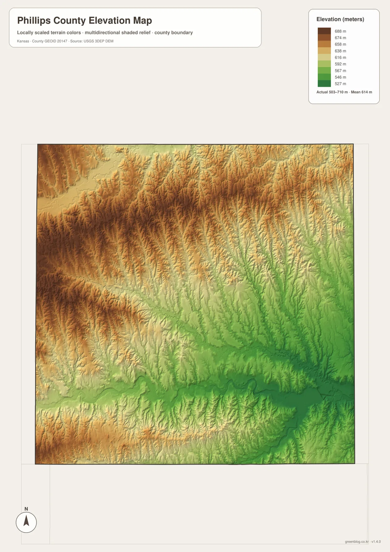
The Long Island and western Logan sides retain more of the higher terrain, although Logan itself is close to the main river valley. In the east, closely spaced tributaries break the uplands into narrow ridges before reaching the larger Solomon lowland.
The elevation surface is generalized for county-scale comparison. It is not survey-grade or engineering-grade measurement and should not be used for parcel elevations, construction grades, drainage design, or legal boundary work.
Kirwin National Wildlife Refuge occupies the county’s largest reservoir landscape
Kirwin National Wildlife Refuge surrounds the Kirwin Reservoir area in southeastern Phillips County. The U.S. Fish and Wildlife Service describes the refuge as lying in the rolling hills and narrow valley of the North Fork Solomon River, where eastern tall-grass prairie meets western short-grass plains.
Phillips County’s official refuge page lists the protected area at 10,778 acres and notes that it was established in 1954 to conserve migratory-bird habitat. On the supplied maps, the reservoir sits in one of the county’s lowest broad basins, bordered by higher rolling ground.
Reservoir level, boat-ramp availability, and recreation conditions can change with water supply and season. Visitors should check the current U.S. Fish and Wildlife Service refuge information before planning boating, fishing, or other water-dependent activities.
Phillipsburg sits above the main river valley in Deer Creek uplands
Phillips County’s historical material places Phillipsburg in the uplands of Deer Creek rather than directly on the North Fork Solomon River. That distinction is visible on the physical maps: Phillipsburg occupies rolling central terrain, while the broadest river lowland remains farther south.
Kansas Tourism highlights the historic courthouse square and the city’s long-standing role as the county’s commercial center. The road and city maps reinforce that role, with Phillipsburg standing well above the surrounding communities on the supplied city index.
Following Phillipsburg toward Kirwin shows the terrain stepping down into the reservoir basin
Moving from Phillipsburg toward Kirwin crosses several tributary valleys before reaching the North Fork Solomon River and the reservoir. Battle Creek and Spring Creek provide intermediate low corridors, while the elevation image shows the broader southeastern terrain becoming progressively lower.
The Logan and Long Island sides offer the opposite contrast. Western Phillips County contains more extensive uplands, and the smaller creeks cut narrower valleys before reaching the major river system. Comparing one route at a time makes the relationship between roads, streams, and relief much easier to understand.
For posters, classroom prints, or presentation slides, use the original JPG files in the download archive rather than enlarging the web previews. Small road shields, creek labels, town names, and the elevation legend remain clearer at the higher resolution.
Frequently Asked Questions
Which city is largest on the supplied city index?
Phillipsburg ranks first at 2,130, followed by Logan at 598, Agra at 244, Prairie View at 156, Long Island at 136, and Kirwin at 63. These are map index values rather than current official population estimates.
Which river feeds Kirwin Reservoir?
Kirwin Reservoir lies on the North Fork Solomon River in southeastern Phillips County. The river enters from the west and expands into the reservoir near Kirwin and the surrounding national wildlife refuge.
Can the 503–710 meter elevation image be used for surveying?
No. It is a generalized county-scale terrain image for comparing uplands with lower river valleys. Parcel elevations, engineering grades, drainage design, and legal boundary work require more precise official data and, where needed, professional surveying.
Map File Information
The archive contains the Phillips County, Kansas general county map, city map, terrain-and-water map, and elevation map as original high-resolution JPG files.
- Included Files: Use only the versions confirmed in the article and supplied images
- File Type: Use the confirmed download contents
- Intended Use: Printing, education, presentations, and map-based projects
Related Maps
Sources and references
- Phillips County, Kansas official website — county government and Phillipsburg information
- Phillips County: History — county boundaries, establishment, and regional background
- U.S. Fish and Wildlife Service: Kirwin National Wildlife Refuge — refuge setting, North Fork Solomon River valley, and current visitor information
- Kansas Tourism: Phillipsburg — Phillipsburg attractions and community information
- U.S. Census Bureau TIGER/Line Shapefiles — county boundary and geographic reference data
- USGS 3D Elevation Program — elevation and terrain reference data
Green Map creates custom-edited map images using open geographic data sources such as geoBoundaries, Natural Earth, OpenStreetMap, and government open data.
These maps are edited visual materials, not raw data files, and are provided for education, documents, presentations, and graphic reference.