Kiowa County lies in southwestern Kansas, where Greensburg provides the clearest reference for roads, settlement, creek valleys, and the county’s west-to-east drop in elevation. Greensburg is the county seat and largest city, Haviland lies to the east, and Mullinville sits near the western side. U.S. 54 and U.S. 400 connect all three communities, while U.S. 183 provides the principal north-south route through Greensburg. High-resolution JPG versions of the maps can be downloaded together from the ZIP box below. High-resolution map files are available for download in the section below.
The northern county is shaped by Rattlesnake Creek and its branches, while the Medicine Lodge River crosses the south. East Fork Rattlesnake Creek, South Branch Rattlesnake Creek, Mule Creek, Soldier Creek, and other tributaries cut long valleys into the plains. Elevation ranges from about 533 to 748 meters with a mean near 666 meters, showing much higher western and southwestern ground and lower eastern and southeastern terrain.
The Kansas Historical Society records that Kiowa County was established in 1867, organized in 1886, and named for the Kiowa Indian tribe. Greensburg remains the county seat. The city is also widely known for the 2007 EF5 tornado that destroyed much of the community and for the rebuilding that followed, giving this small county center a national historical significance beyond its population.
Table of Contents
Greensburg anchors the U.S. 54–400 corridor
Greensburg sits near the north-central part of Kiowa County and is the easiest starting point on the general map. U.S. 54 and U.S. 400 form the principal east-west corridor, linking Mullinville on the west with Haviland on the east. U.S. 183 runs south from the Greensburg area and provides the strongest north-south reference across the county.
Mullinville lies close to the western boundary, while Haviland occupies the eastern side of the same highway corridor. Much of the land south of these towns is sparsely settled, with long rural roads crossing agricultural and grazing areas. The county’s three major communities therefore form a clear northern settlement band.
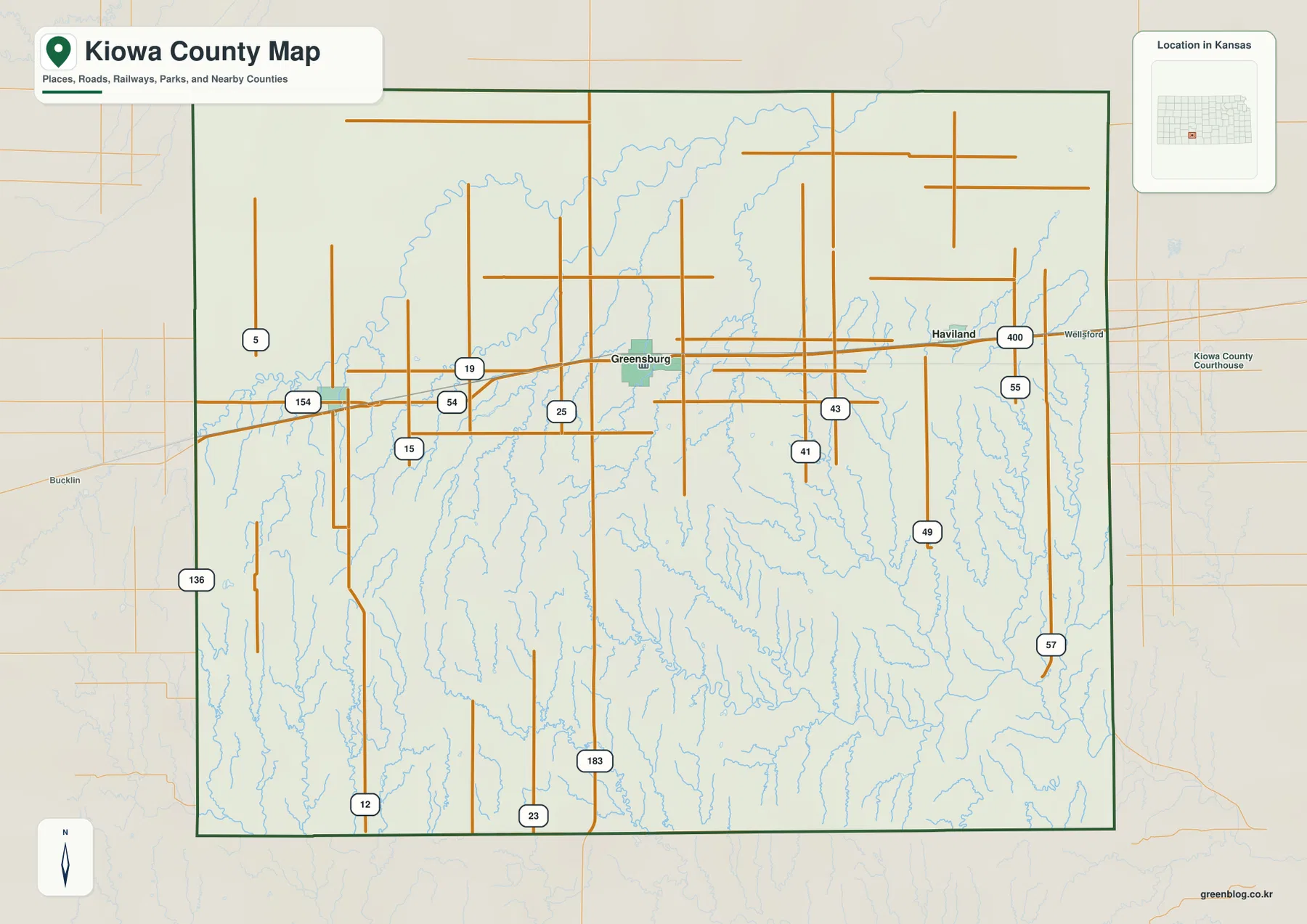
Wellsford and the Kiowa County Courthouse appear as additional local references, and Bucklin lies beyond the western boundary in Ford County. The road grid is generally straight, but creek valleys interrupt that pattern with bridges and bends. This map is intended for county-scale orientation rather than live navigation, so current construction, unpaved-road conditions, wind, and winter weather should be checked separately.
Greensburg, Haviland, and Mullinville form a compact three-city pattern
The city map ranks Greensburg first, Haviland second, and Mullinville third. The displayed source values are 722 for Greensburg, 603 for Haviland, and 214 for Mullinville. Those numbers may differ from later estimates, but the basic settlement pattern is stable: these three communities contain nearly all of the county’s visible urban concentration.
The map shows both Greensburg–Haviland and Greensburg–Mullinville at about 10 miles of direct distance. These are straight-line measurements rather than road-driving distances. Their similar spacing along the U.S. 54/400 corridor makes the county’s urban geography unusually easy to understand.
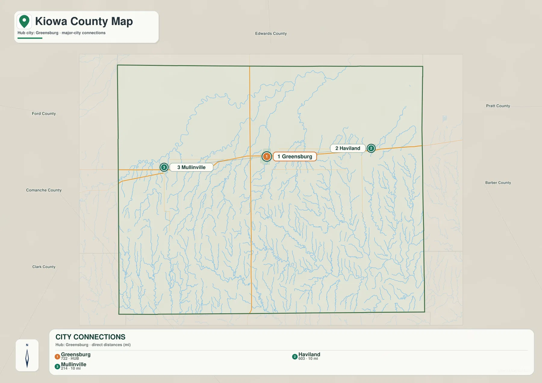
The Kansas Historical Society lists Greensburg as the county seat, and county government remains based there today. Haviland and Mullinville are smaller, but they serve as the principal eastern and western town references for surrounding rural areas.
Rattlesnake Creek dominates the north while the Medicine Lodge River crosses the south
Rattlesnake Creek is the strongest northern drainage on the terrain map. It enters from the west, makes large bends across the upper county, and receives South Branch Rattlesnake Creek from the west-central area. East Fork Rattlesnake Creek creates another long valley through the central-northern plains.
The southern half belongs to the Medicine Lodge River system. The main river crosses the county from west to east, North Branch Medicine Lodge River joins from the north, and Mule Creek descends from the southwest. Soldier Creek and Spring Creek form long eastern valleys, while Thompson Creek adds another branch in the southeast.
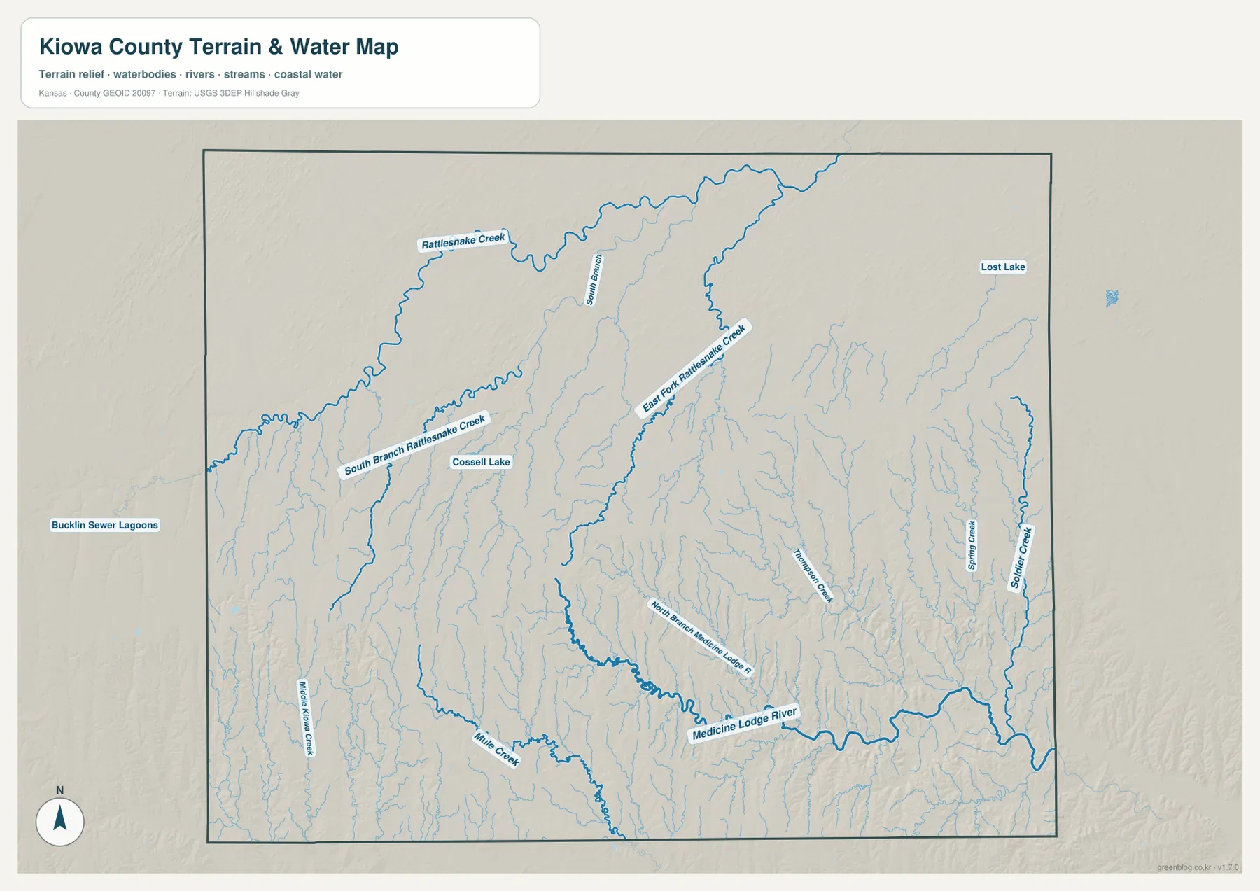
Cossell Lake appears in the west-central county and Lost Lake in the northeast. These smaller water bodies are useful landmarks within an otherwise open plains landscape. The map shows geographic position rather than live streamflow, flood risk, or water quality; current conditions should be checked through USGS or responsible local agencies.
Elevation drops from 748-meter western uplands toward the southeast
Kiowa County ranges from approximately 533 to 748 meters in elevation and averages near 666 meters. Brown and orange dominate the west and southwest, while yellow-green and green spread across the east. The county therefore has a strong overall decline from the western uplands toward lower eastern terrain.
The southeastern corner is especially low because the Medicine Lodge River and many tributaries have cut deeply into the surface. Rattlesnake Creek and its branches also carve narrow valleys through higher western ground. Even though Kiowa County belongs to the broad High Plains region, the shaded relief reveals a surprisingly complex network of ridges and stream-cut hollows.
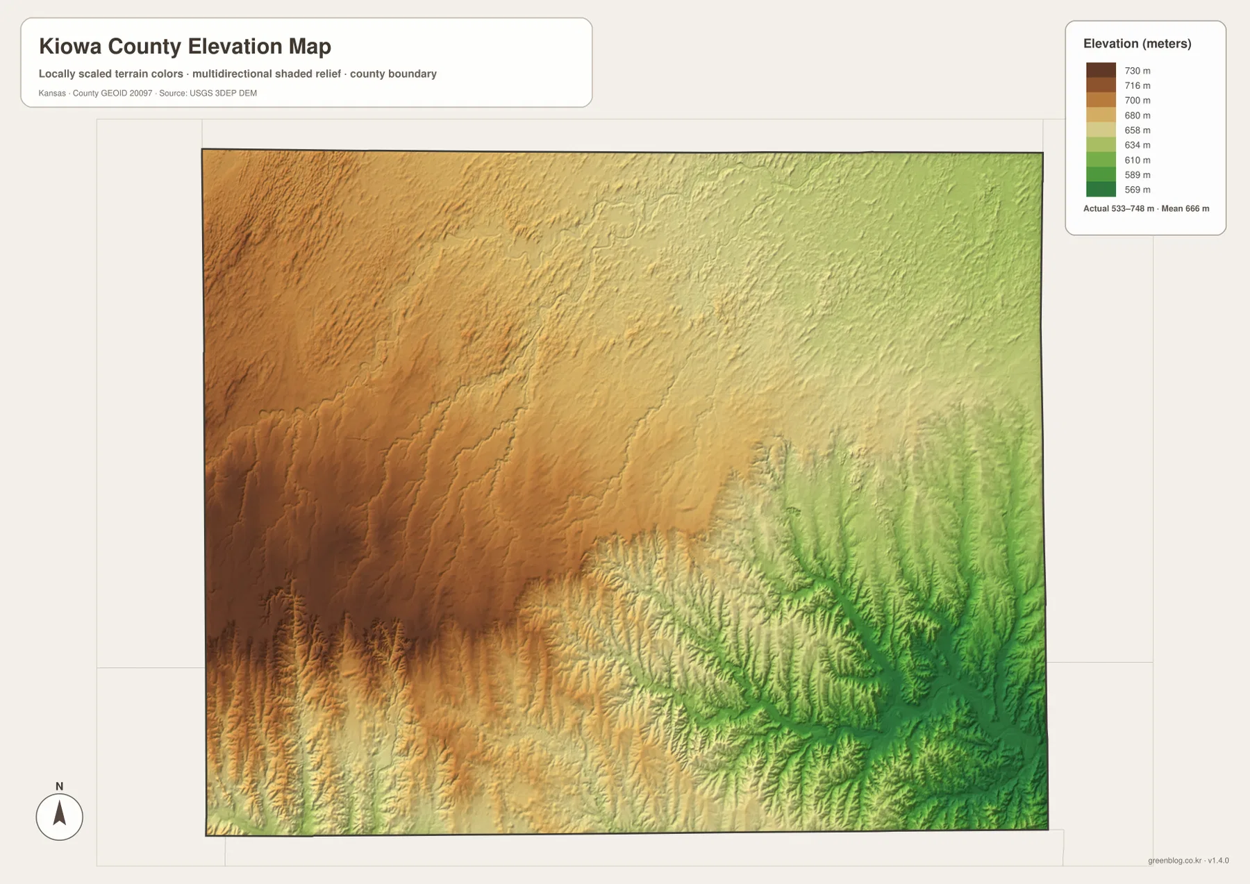
This elevation surface is intended for county-scale comparison rather than survey-grade measurement. It should not be used to establish exact parcel elevations, design drainage, or replace engineering and legal survey data. Its main value is showing how sharply the land falls from the Mullinville side toward Haviland and the southeastern drainage network.
Greensburg became the county seat along an important travel corridor
Kiowa County was established in 1867 and organized in 1886. The Kansas Historical Society records Greensburg as the county seat and notes that the county was named for the Kiowa Indian tribe. County government remains based in Greensburg, reinforcing its central role on the modern map.
The U.S. 54 corridor also has older transportation roots. Kansas Historical Society marker material describes H. F. Green’s stage route from Kingman west to Greensburg, a road that later became part of the Cannonball Highway and then U.S. 54. The modern Mullinville–Greensburg–Haviland route therefore follows a corridor that served regional travel long before today’s highway system.
The terrain helps explain that continuity. Broad east-west uplands and river crossings offered practical travel routes across the plains, while the major creek valleys influenced where roads could pass. Modern highways are engineered very differently, but they still respond to the same large-scale geography.
The 2007 Greensburg tornado changed the county center
On May 4, 2007, an EF5 tornado devastated Greensburg. The National Weather Service documents extensive destruction across the city, followed by years of rebuilding. The event became one of the defining modern chapters in Kiowa County history.
This map set does not show the tornado path or damage footprint, but it does show that Greensburg remains the administrative and transportation center. The courthouse, highway corridor, and connections to Haviland and Mullinville continue to organize county life despite the scale of the disaster.
Greensburg’s Big Well also survived the tornado and later became part of a new museum and visitor center. That combination of local heritage and post-tornado rebuilding gives the small city a much larger public identity than its population alone would suggest.
Using the maps for printing, study, and county orientation
For road orientation, begin with Greensburg and follow U.S. 54/U.S. 400 west to Mullinville and east to Haviland, then use U.S. 183 for the main north-south reference. For physical geography, compare Rattlesnake Creek in the north with the Medicine Lodge River in the south and trace East Fork Rattlesnake Creek, Mule Creek, and Soldier Creek through the intervening uplands.
The high-resolution JPG files in the ZIP are better suited than the reduced web previews for printing, classroom projects, local-history study, and close inspection of road and water labels. Current road conditions, live stream information, parcel boundaries, and exact elevations should always be checked against the latest authoritative sources when those details matter.
Frequently Asked Questions
Where is Greensburg on the Kiowa County map?
Greensburg sits near the north-central part of the county and serves as the county seat and largest city. U.S. 54 and U.S. 400 run east-west through the area, while U.S. 183 provides the main north-south reference.
How are Rattlesnake Creek and the Medicine Lodge River positioned?
Rattlesnake Creek and its branches cross the northern half of the county, while the Medicine Lodge River and related tributaries form the major drainage system across the south. Together they divide the county into several broad uplands and lower stream valleys.
Can the 533–748 meter elevation map be used for surveying?
No. The elevation map is a county-scale visual reference for comparing uplands and stream valleys. Exact parcel elevations, construction design, drainage engineering, and legal surveys require purpose-built data and professional methods.
Map File Information
Download the high-resolution JPG files corresponding to the Kiowa County general, city distribution, terrain-and-water, and elevation maps in one ZIP archive.
- Included Files: Use only the versions confirmed in the article and supplied images
- File Type: Use the confirmed download contents
- Intended Use: Printing, education, presentations, and map-based projects
Related Maps
Sources and references
- Kiowa County, Kansas official website — county government and Greensburg administrative information
- Kansas Historical Society — Kiowa County, Kansas — establishment, organization, county seat, and name origin
- National Weather Service — Greensburg 5 years after — the 2007 EF5 tornado and rebuilding context
- U.S. Census Bureau TIGER/Line — boundary, road, and geographic data resources
- USGS National Hydrography — hydrography and stream-network data information
- USGS 3D Elevation Program — elevation data information
Green Map creates custom-edited map images using open geographic data sources such as geoBoundaries, Natural Earth, OpenStreetMap, and government open data.
These maps are edited visual materials, not raw data files, and are provided for education, documents, presentations, and graphic reference.