Harvey County lies in south-central Kansas, where Newton provides the clearest starting point for understanding settlements, highways, the Little Arkansas River, Sand Creek, and the county’s east-west relief. Newton is the county seat and largest city. Hesston and North Newton lie to the north, Halstead and Burrton to the west, and Sedgwick to the south. U.S. 50, I-135, and K-15 form the strongest road references. High-resolution JPG versions of the maps can be downloaded together from the ZIP box below. High-resolution map files are available for download in the section below.
The Little Arkansas River and Sand Creek are the county’s most useful natural landmarks. The Little Arkansas winds through western and central Harvey County, while Sand Creek passes the Newton area and continues south toward Sedgwick. East Emma Creek, West Emma Creek, and Black Kettle Creek add smaller valleys around the county center. The elevation surface ranges from about 405 to 476 meters with a mean near 440 meters, clearly separating the lower central-western drainage country from higher eastern terrain.
Harvey County was established in 1872, and the Kansas Historical Society identifies Newton as the county seat. Newton had already become a major transportation point in 1871 when the Santa Fe railroad arrived and cattle from the Chisholm Trail were shipped east. The modern map still concentrates highways, rail corridors, settlement, and drainage around Newton, so the county’s transportation history fits naturally with its geography.
Table of Contents
Newton at the junction of U.S. 50, I-135, and K-15
Newton is the dominant place on the general county map. U.S. 50 approaches from Burrton and Halstead in the west, while I-135 runs north and south along the eastern side of the Newton urban area. K-15 extends south from Newton, and K-196 provides an eastward connection toward Whitewater. Together these routes make Newton the simplest road anchor for the entire county.
North Newton lies immediately north of Newton, and Hesston is farther north near I-135. Halstead and Burrton mark the western U.S. 50 corridor, while Sedgwick gives the southern part of the county a clear settlement reference. Walton sits northeast of Newton and helps orient the eastern rural area. Large agricultural spaces separate these communities outside the Newton cluster.
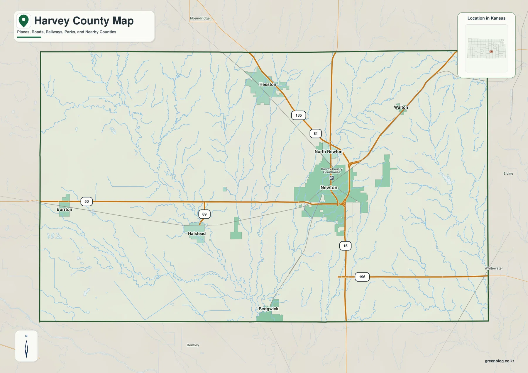
Much of the rural road network follows a regular grid, but river and creek valleys interrupt that pattern near crossings and bridges. The Little Arkansas River creates a broad low corridor west and south of Newton, while Sand Creek cuts through the central-eastern area. The map is intended for county-scale orientation rather than live navigation, so current construction, flooding, winter weather, and local road conditions should be checked separately.
Newton, Hesston, Halstead, and the six-city distribution
The city distribution map ranks Newton first, followed by Hesston, Halstead, North Newton, Sedgwick, and Burrton. The population labels come from the dataset used to produce the map and may differ from newer estimates, but the overall pattern is clear: Newton is substantially larger than the other communities, while several smaller towns divide the northern, western, and southern county.
Hesston and North Newton provide the strongest northern references near the I-135 and U.S. 81 corridor. Halstead and Burrton organize the western U.S. 50 side, and Sedgwick marks the southern Little Arkansas–Sand Creek area. Reading the city distribution together with the road map makes it easier to see how each community occupies a different transportation or drainage setting.
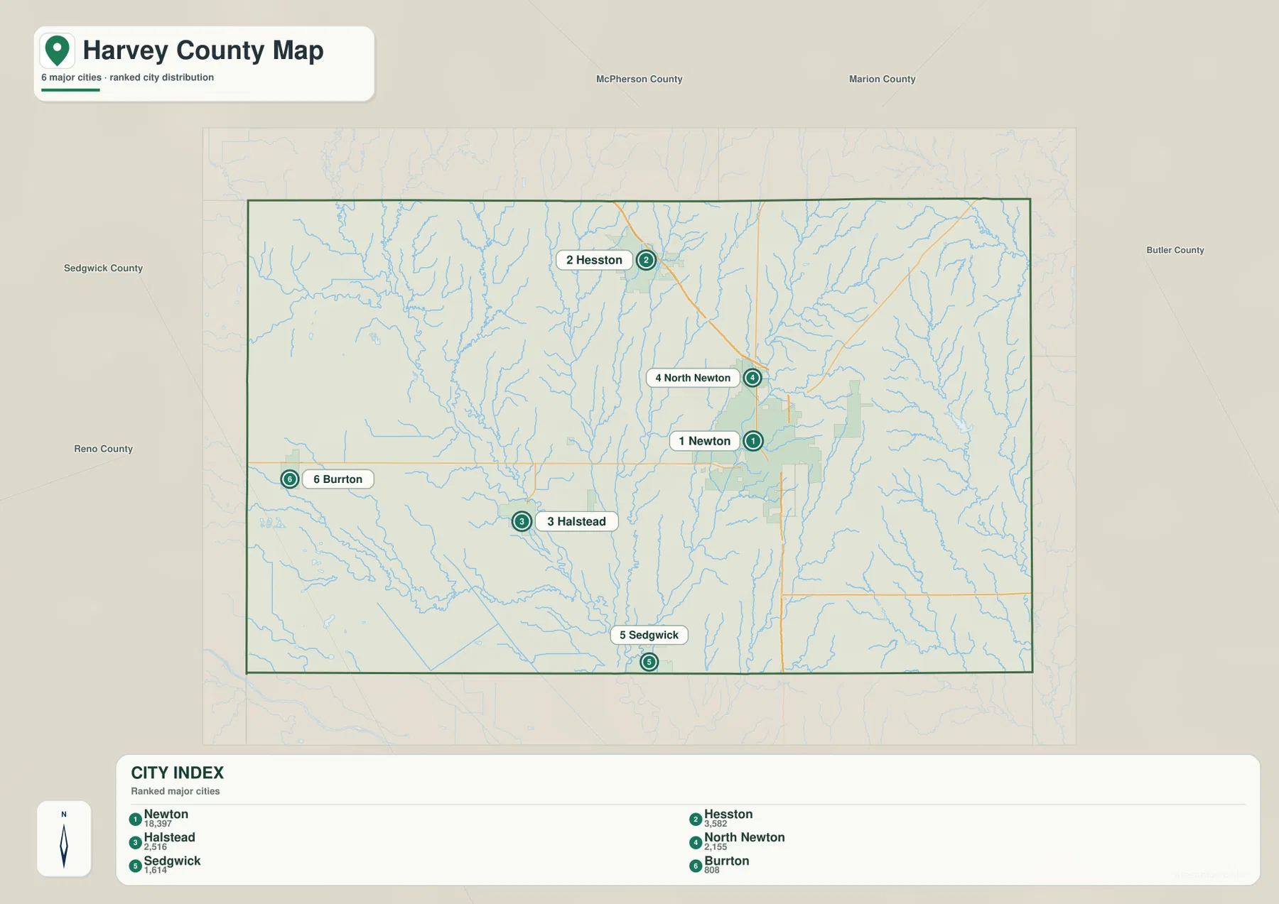
The Kansas Historical Society lists Newton as the county seat, and the present Harvey County government is also based there. The county profile records a 2020 population of 34,024. Newton’s administrative role and its much larger city footprint match the way it dominates both the general and city maps.
Little Arkansas River, Sand Creek, and the low country around Newton
The terrain and water map is organized around the Little Arkansas River in western and central Harvey County. The river bends southward through a broad low valley, receiving numerous small tributaries. Black Kettle Creek enters the system from the west-central uplands, and the surrounding terrain becomes visibly smoother and lower near the main river corridor.
Sand Creek is the strongest drainage east and south of Newton. East Emma Creek and West Emma Creek descend from the north toward the Newton area, helping define the low terrain between Hesston, North Newton, and the county seat. Kansas Historical Society trail research also connects Sand Creek with branches of the cattle trail that approached Newton during the Chisholm Trail era.
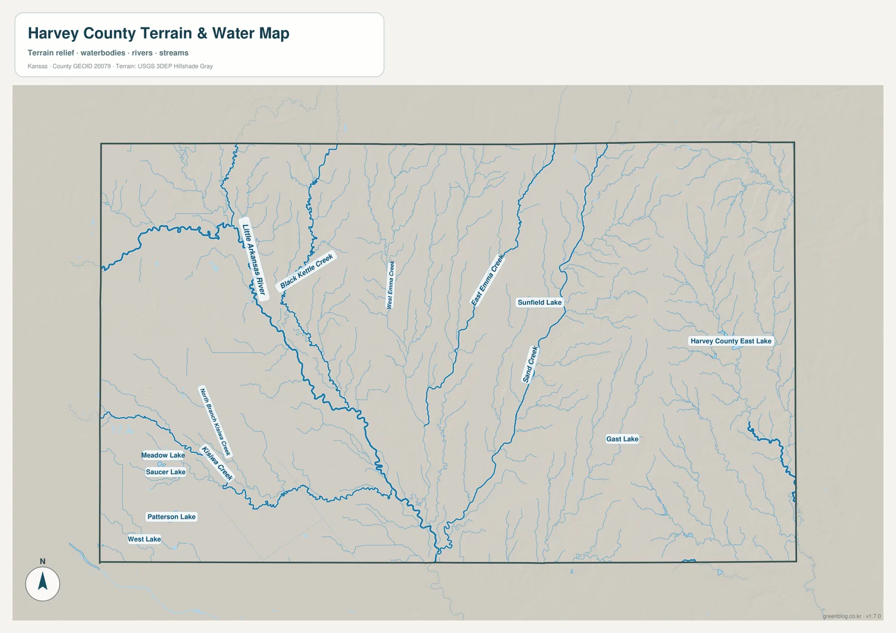
Several smaller water bodies are labeled, including Sunfield Lake, Harvey County East Lake, and Gast Lake, plus Meadow Lake, Saucer Lake, Patterson Lake, and West Lake in the west. The map is a geographic reference rather than a live flood or streamflow product. Current river stage, flood conditions, or water quality should be checked through USGS or responsible local agencies.
A 405–476 meter contrast between river lowlands and the higher east
The elevation map shows an actual county range of approximately 405 to 476 meters and a mean elevation near 440 meters. The broadest low green terrain follows the Little Arkansas River through the central and western county. Sand Creek and its tributaries create additional low corridors south and east of Newton.
Eastern and northeastern Harvey County rise sharply by local standards. Brown and orange ridges are cut by many short tributaries, producing a much more textured surface than the western lowland. East Emma Creek and West Emma Creek form narrow green valleys that connect this higher ground with the lower Newton area.
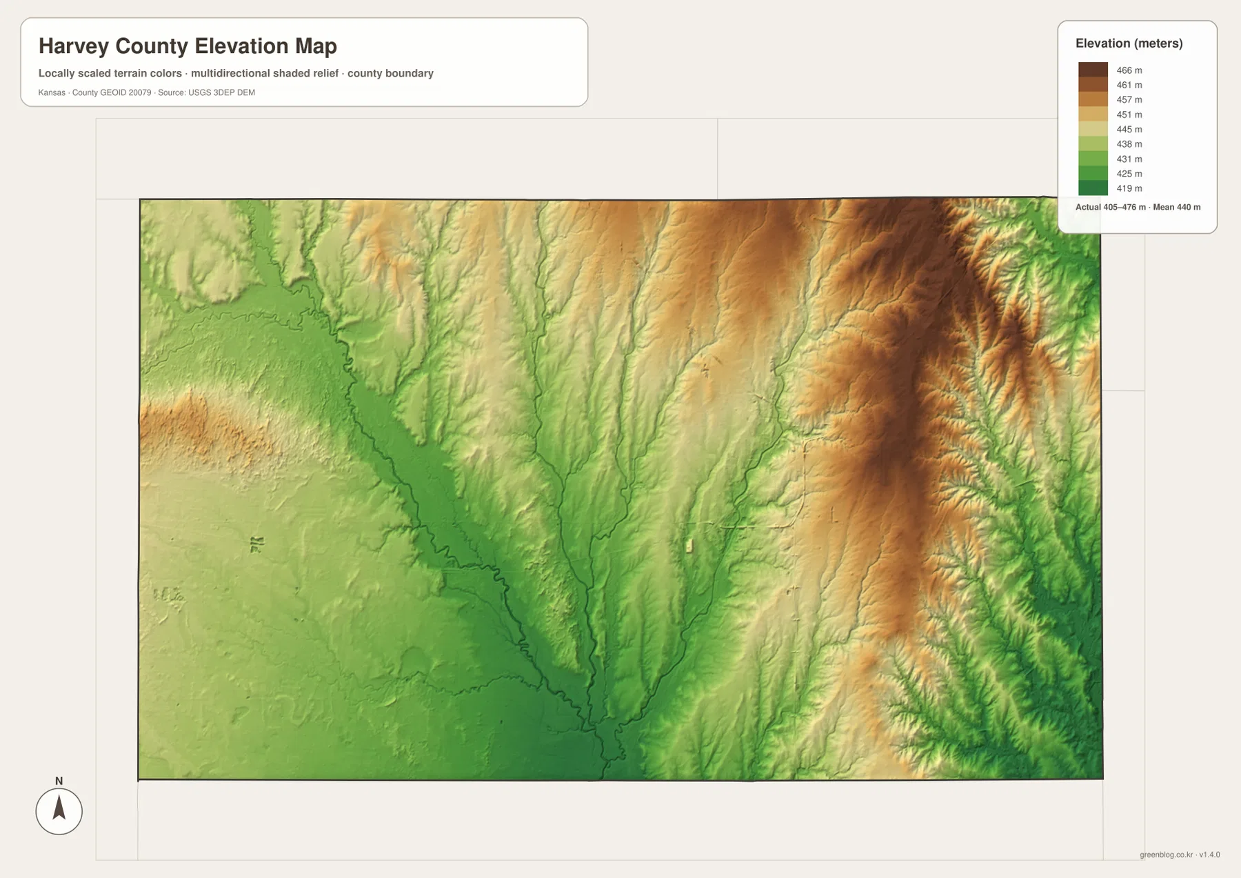
This elevation surface is intended for county-scale comparison rather than survey-grade measurement. It should not be used to establish exact parcel elevations, design drainage, or replace engineering and legal survey data. Its value is visual context: Newton lies close to the transition between the broad Little Arkansas lowland and the higher terrain farther east.
Newton’s railroad and Chisholm Trail history in geographic context
Newton’s rise was closely tied to rail transportation. Kansas Historical Society records show that the Atchison, Topeka and Santa Fe railroad reached Newton in 1871, making the town a temporary western rail terminus. During that same year, large numbers of Texas cattle were brought to Newton and shipped east, giving the town a brief but famous period as a Kansas cowtown.
The Chisholm Trail through Harvey County also followed natural corridors. Kansas Historical Society trail research describes cattle routes moving north from Wichita along the Little Arkansas area and then following Sand Creek toward Newton. The water map helps make that description tangible because both drainages form continuous low routes through the county.
Harvey County itself was established in 1872 and named for James M. Harvey, a Kansas governor and U.S. senator. Later development spread beyond Newton into Hesston, North Newton, Halstead, Burrton, and Sedgwick, but the county seat remained the main transportation and administrative center. The modern city pattern therefore preserves part of the geography created during the early railroad era.
Using the maps for printing, study, and county orientation
For basic orientation, begin with Newton and U.S. 50, then connect Halstead and Burrton to the west and Hesston to the north along I-135. For physical geography, follow the Little Arkansas River and Sand Creek, then compare East and West Emma Creek with the elevation view. That combination quickly separates the lower river country from the higher eastern side.
The high-resolution JPG files in the ZIP are better suited than the reduced web previews for printing, classroom projects, Newton and Chisholm Trail history materials, and close inspection of labels. They are useful for county overviews and regional comparison, but current roads, live stream conditions, parcel boundaries, and exact elevations should always be checked against the latest authoritative sources when those details matter.
Frequently Asked Questions
Where is Newton on the Harvey County map?
Newton sits slightly east of the county center and serves as the county seat and largest city. U.S. 50 and I-135 meet the wider Newton transportation area, while North Newton lies immediately to the north, making this urban cluster the easiest first reference for county orientation.
How do the Little Arkansas River and Sand Creek shape the Newton area?
The Little Arkansas River creates a broad low corridor across western and central Harvey County, while Sand Creek passes the Newton area and continues south toward Sedgwick. East and West Emma Creek add smaller valleys from the north, helping form the county’s central drainage network.
Can the 405–476 meter elevation map be used for surveying?
No. The elevation map is a county-scale visual reference for comparing river lowlands and higher terrain. Exact parcel elevations, construction design, drainage engineering, and legal surveys require purpose-built data and professional methods appropriate to those tasks.
Map File Information
Download the high-resolution JPG files corresponding to the Harvey County general, city distribution, terrain-and-water, and elevation maps in one ZIP archive.
- Included Files: Use only the versions confirmed in the article and supplied images
- File Type: Use the confirmed download contents
- Intended Use: Printing, education, presentations, and map-based projects
Related Maps
Sources and references
- Harvey County, Kansas official website — county government and Newton information
- Kansas Historical Society — Harvey County, Kansas — county seat, establishment, population, and name origin
- Kansas Historical Society — Pioneer trails in Harvey County — Newton, Little Arkansas River, Sand Creek, and Chisholm Trail context
- U.S. Census Bureau TIGER/Line — boundary, road, and geographic data resources
- USGS National Hydrography — hydrography and stream-network data information
- USGS 3D Elevation Program — elevation data information
Green Map creates custom-edited map images using open geographic data sources such as geoBoundaries, Natural Earth, OpenStreetMap, and government open data.
These maps are edited visual materials, not raw data files, and are provided for education, documents, presentations, and graphic reference.