Edwards County lies in southwestern Kansas, where Kinsley provides the clearest starting point for understanding settlements, roads, drainage, and relief. Kinsley is the county seat, with Lewis and Belpre to the east and Offerle to the west. The main communities therefore form a simple east-west sequence across a largely rural county. This page explains the features visible on the supplied maps, and matching high-resolution JPG files can be downloaded together from the ZIP box later on the page. High-resolution map files are available for download in the section below.
The Arkansas River is the most prominent water feature in the western part of the county, accompanied by Coon Creek, Little Coon Creek, and Dry Coon Creek. Wild Horse Creek appears farther east, while Rattlesnake Creek crosses the southeastern area. The elevation surface ranges from about 619 to 721 meters with a mean near 662 meters. Higher ground dominates the west and northwest, and the county generally becomes lower toward the east.
The Kansas Historical Society places Edwards County in both the Arkansas River Lowlands and the High Plains. That regional description matches the supplied maps well. The western side contains elevated surfaces cut by many creek valleys, while the river corridor and much of the eastern half lie lower. Kinsley sits close enough to these contrasting landscapes that it works as a useful reference for both human and physical geography.
Table of Contents
Kinsley and the east-west line of Edwards County communities
Kinsley is the easiest place to locate on the general county map. It sits slightly west of the county’s center and is surrounded by several numbered roads. Offerle lies to the west, while Lewis and Belpre extend eastward in sequence. Because the major communities are concentrated along this broad east-west band, the basic settlement pattern is easier to understand than in counties where towns are scattered in every direction.
U.S. 50 and U.S. 56 are labeled west of Kinsley, and U.S. 183 appears farther south. The county map also shows numerous numbered state and local routes, including 1, 3, 12, 13, 14, 19, 26, 35, 36, 42, 53, and 236. A reader does not need to memorize every route number. Starting with Kinsley and the main east-west corridor provides enough structure to locate the smaller rural roads and surrounding county boundaries.
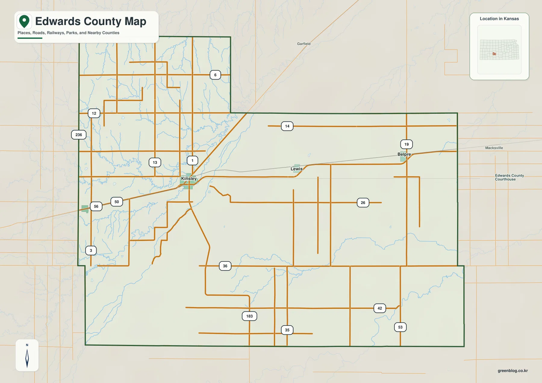
The western side of the map contains a denser combination of roads and drainage channels, especially around Kinsley and toward Offerle. East of Lewis, the distance between settlement labels grows and long rural roads cross broad open areas. This contrast helps explain why the county can feel different on either side of Kinsley even though the administrative boundary is relatively compact. The map is intended for county-scale orientation rather than live navigation, so current road construction and closures should be checked with up-to-date travel information.
Lewis, Belpre, and Offerle around the Kinsley hub
The city connection map reduces the county to four prominent communities. Kinsley is marked as the hub, Lewis is about 9 miles east, Belpre about 17 miles east, and Offerle about 9 miles west. These are direct-distance references that make the east-west settlement pattern immediately visible. They are useful for scale and orientation, but they should not be treated as current driving mileage.
The official Edwards County website also identifies Kinsley as the county seat and largest city while describing Lewis, Belpre, and Offerle as the county’s other principal communities. That local description closely matches what the map shows. Kinsley functions as the central reference, with a short westward connection to Offerle and a longer sequence eastward through Lewis to Belpre.
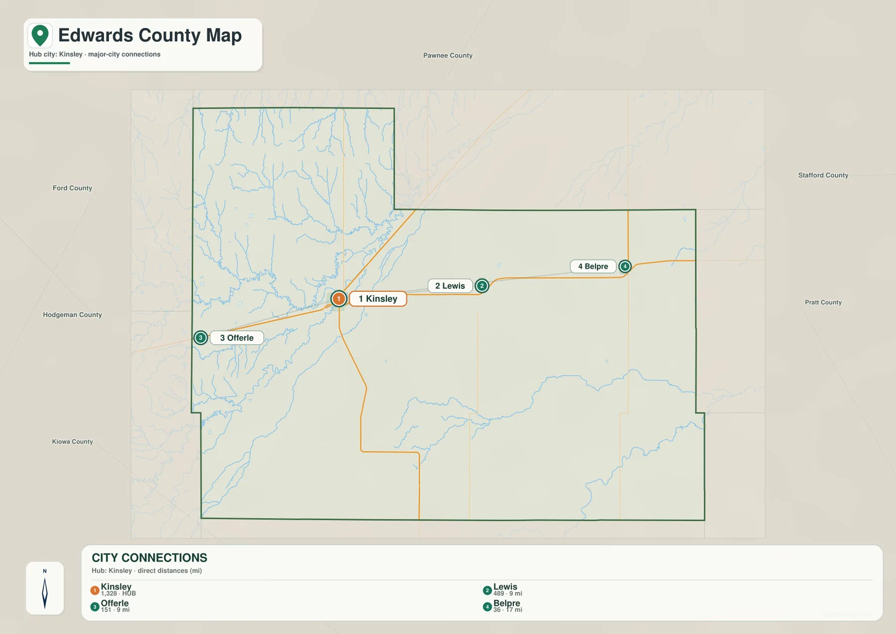
This simple city layout is especially helpful when the terrain maps are introduced. Offerle lies closer to the more strongly dissected western landscape, while Lewis and Belpre sit farther into the lower eastern side of the county. The city map does not show those elevation differences directly, but placing the communities first makes the later water and elevation views easier to interpret.
Arkansas River and the Coon Creek valleys west of Kinsley
The terrain and water map is dominated by the Arkansas River in the west and southwest. The river enters along the western side, bends through the lower country near Kinsley, and continues southward. Coon Creek follows a nearby valley, while Little Coon Creek and Dry Coon Creek create additional branching channels from the northwest and north-central areas. Together they form the most concentrated drainage network shown in the county.
Little Coon Creek approaches the Coon Creek system from the northwest, and Dry Coon Creek runs through terrain north and northeast of Kinsley. The close spacing of these channels explains the deeply textured appearance of the western elevation surface. The water map is especially useful here because a road-only view can make the landscape look simpler than it actually is.
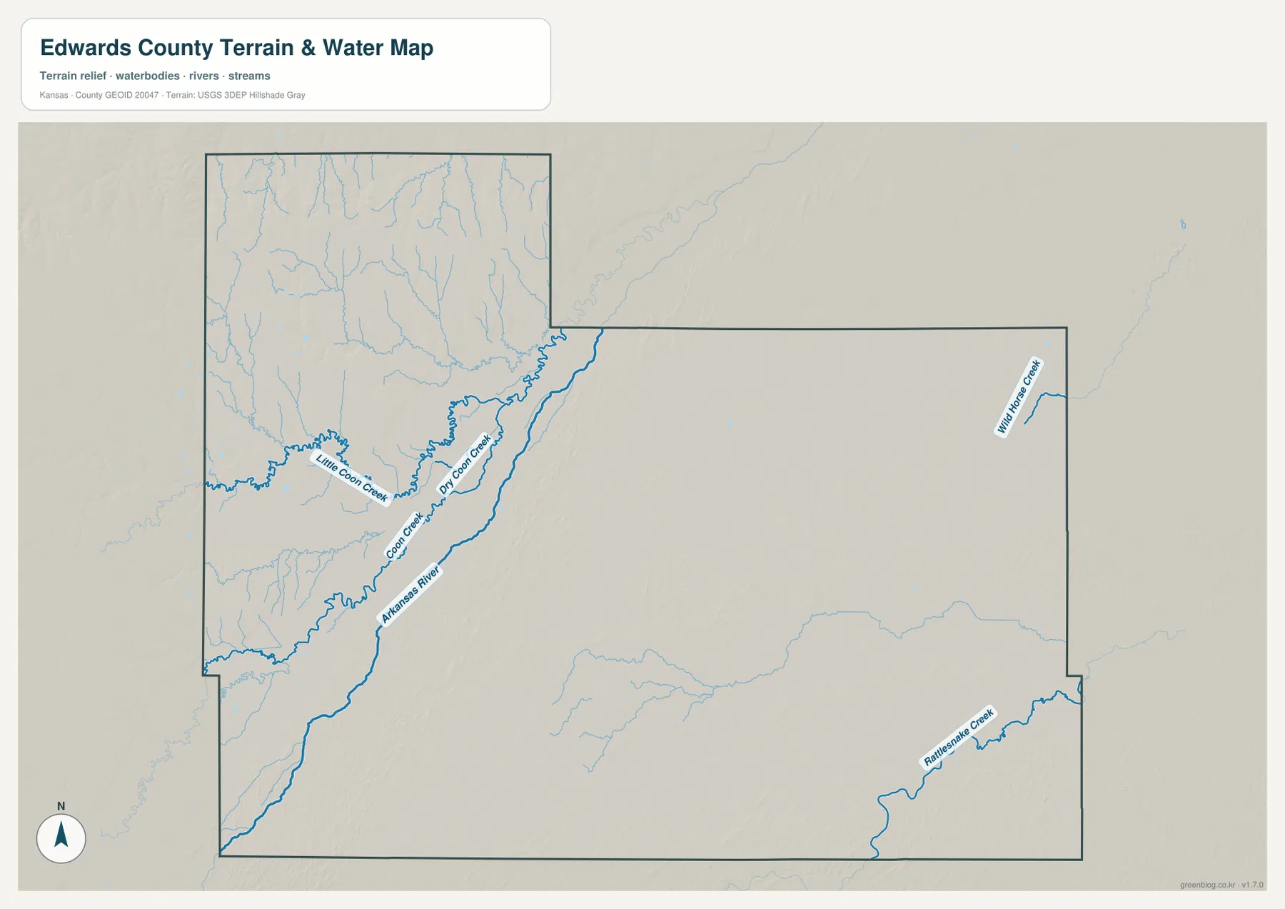
The eastern side has fewer large labeled streams, but it is not without drainage. Wild Horse Creek appears in the northeast, and Rattlesnake Creek crosses the southeast. These channels show that lower valleys continue across the county even where the settlement and road maps look relatively open. This map is not a real-time flood, streamflow, or water-quality product; current conditions require observations from USGS or another responsible agency.
A 619–721 meter transition from western uplands to lower eastern ground
The elevation map shows an actual range of approximately 619 to 721 meters and a mean elevation of about 662 meters. Brown and orange tones dominate the west and northwest, marking the highest broad surfaces. Moving east, the colors shift through tan and yellow-green into larger areas of green. The overall effect is a clear west-to-east decline in elevation across much of Edwards County.
The northwest is especially rugged at this scale because many small streams cut into the higher surface. Around the Arkansas River and Coon Creek system, narrow low corridors interrupt the surrounding uplands. The central portion becomes smoother, and the eastern half contains broader lower surfaces, although small valleys remain visible in the shaded relief. The result is not a mountainous landscape but a high plain that has been dissected by drainage.
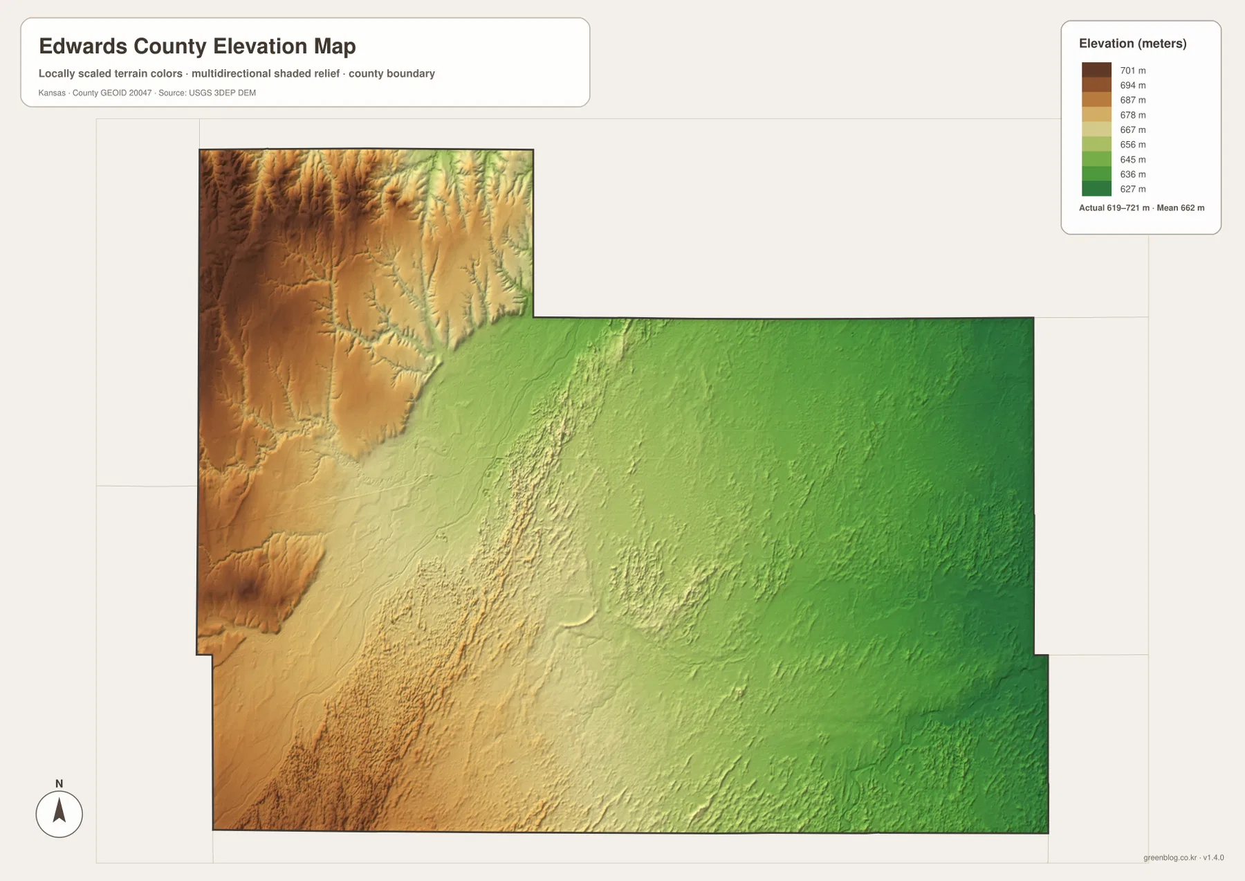
This elevation surface is meant for broad geographic comparison rather than survey-grade measurement. It should not be used to establish an exact parcel elevation, design drainage, or replace engineering or legal survey data. Its value is visual context: a reader can see where Kinsley sits relative to the higher western terrain, the lower eastern side, and the valleys followed by the Arkansas River and its neighboring creeks.
Arkansas River Lowlands beside the High Plains
The Kansas Historical Society identifies Edwards County with both the Arkansas River Lowlands and the High Plains. The map set makes that combination easy to visualize. The river and creek valleys create lower corridors in the west, while nearby uplands rise sharply in color on the elevation map. Farther east, the terrain generally lowers but still retains broad plain surfaces cut by smaller drainage lines.
Kinsley occupies a useful position for explaining this transition. The Arkansas River and Coon Creek system lie close to the city on the west and southwest, while the higher northwestern terrain is also nearby. Following the community line east through Lewis and Belpre moves into lower country with fewer deeply cut valleys. That relationship between settlement, roads, water, and relief gives the county a clear geographic story without relying on technical terminology.
The county also has a strong historical connection to the Arkansas River corridor. The Kansas Historical Society notes that the Santa Fe Trail commerce route followed the river through Edwards County. The historical route should not be treated as identical to today’s roads, but it provides useful context for why the river valley mattered as a travel corridor long before the modern highway network developed.
Using the maps for printing, study, and county orientation
For a quick understanding of the county, begin with Kinsley and then place Offerle to the west and Lewis and Belpre to the east. The general map adds major routes and county boundaries, while the city connection view makes the settlement spacing easier to compare. This approach works well for school projects, regional introductions, local-history materials, and basic trip preparation.
For physical geography, follow the Arkansas River and Coon Creek system through the western side before checking Wild Horse Creek and Rattlesnake Creek farther east. The elevation map then explains why the western side appears more strongly dissected and why the broad eastern half sits lower overall. Moving between these views connects town locations with the landforms and waterways around them.
For printing or inclusion in a larger document, the high-resolution JPG files in the ZIP are preferable to the reduced web previews. They preserve labels and terrain detail at a size better suited to enlarged viewing. Anyone republishing or modifying the maps should check applicable source and attribution requirements. Projects that depend on current roads, live stream conditions, property boundaries, or exact elevations should pair these reference maps with the latest authoritative data.
Frequently Asked Questions
Where is Kinsley on the Edwards County map?
Kinsley sits slightly west of the county’s center and serves as the county seat. Lewis and Belpre lie to the east, while Offerle is to the west. The main road network around Kinsley makes it the easiest first reference for locating the county’s principal communities.
What do the Arkansas River and Coon Creek show about the terrain?
The Arkansas River and the Coon Creek system follow some of the county’s most important low corridors in the west. Little Coon Creek and Dry Coon Creek cut into nearby uplands and help explain the strongly textured relief around Kinsley and Offerle. The map shows geographic relationships, not live streamflow or flood conditions.
Can the 619–721 meter elevation map be used for surveying?
No. The elevation map is a county-scale visual reference for comparing uplands and valleys. Exact parcel elevations, construction design, drainage engineering, and legal surveys require purpose-built data and professional methods appropriate to those tasks.
Map File Information
Download the high-resolution JPG files corresponding to the Edwards County general, city connection, terrain-and-water, and elevation maps in one ZIP archive.
- Included Files: Use only the versions confirmed in the article and supplied images
- File Type: Use the confirmed download contents
- Intended Use: Printing, education, presentations, and map-based projects
Related Maps
Sources and references
- Edwards County, Kansas official website — Kinsley and the county’s principal communities
- Kansas Historical Society — Edwards County, Kansas — county seat, regional history, Arkansas River Lowlands, and High Plains context
- U.S. Census Bureau TIGER/Line — boundary and geographic data resources
- USGS National Hydrography — hydrography and stream-network data information
- USGS 3D Elevation Program — elevation data information
Green Map creates custom-edited map images using open geographic data sources such as geoBoundaries, Natural Earth, OpenStreetMap, and government open data.
These maps are edited visual materials, not raw data files, and are provided for education, documents, presentations, and graphic reference.