Webster County sits in north-central Iowa with Fort Dodge as the obvious urban anchor and the Des Moines River as its strongest physical landmark. Fort Dodge spreads across the north-central part of the county, while smaller communities such as Badger, Otho, Callender, Gowrie, and Dayton are separated by broad rural areas. The river enters from the north, passes close to Fort Dodge, and bends toward the southeast through a noticeably lower valley. This page brings those settlement, road, water, and elevation patterns together, and the matching high-resolution JPG maps are available in a downloadable ZIP.
The county looks fairly orderly on the road map because many rural routes run in long straight sections, but the physical landscape is less simple. Lizard Creek and its south branch approach the Des Moines River from the west, Soldier Creek comes from the northeast, and Prairie Creek and Brushy Creek occupy the eastern and southeastern drainage network. The elevation map shows those watercourses as lower green corridors cut into higher ground. Much of the west and northwest stands above the main river valley, creating a stronger relief contrast than a first glance at the transportation grid would suggest.
The four supplied views work best when they are used together instead of treated as separate inventories. The general county map is the quickest way to locate towns and numbered highways. The city layer strips away much of that detail and emphasizes six major communities. The water layer makes the Des Moines River and its tributaries easier to follow, while the elevation layer explains why those channels occupy long low corridors. Reading one place across all four maps is especially useful in Webster County because Fort Dodge, the river, and several road corridors overlap in the same central area.
Table of Contents
Fort Dodge where the highway network meets the river corridor
Fort Dodge is the easiest place to start on the general county map. Iowa 7 approaches from the west and crosses the urban area, while U.S. 169 provides a strong north-south reference through the center of the county. U.S. 20 runs east-west farther south, separating the Fort Dodge area from the more widely spaced towns in the southern half. These roads make the city easy to identify even before smaller streets and streams are considered. Once Fort Dodge is fixed as a reference point, Badger to the north, Otho to the south, Moorland to the southwest, and Duncombe to the east are much easier to place.
The southern road pattern is more open. Callender and Gowrie occupy the southwestern half, Harcourt lies farther east, and Dayton sits in the southeast. The map labels additional numbered routes near those towns, including 53 and 144 in the southwest and 175 near Dayton. U.S. 169 continues southward through the central part of the county and provides a useful visual connection back to Fort Dodge. The roads appear straight across long stretches of farmland, but the later terrain layers show that they repeatedly cross shallow valleys and small drainage lines.
Duncombe and Lehigh are useful for understanding the eastern side because both lie away from the main concentration of Fort Dodge. Duncombe is near the eastern edge of the upper half, while Lehigh is farther southeast and much closer to the Des Moines River valley. The difference matters when the elevation layer is opened: Lehigh is associated with a deeply cut river corridor, whereas other eastern communities sit on broader uplands between tributaries. A road-only view does not explain that contrast, so the county map works best as an orientation layer rather than a complete picture of the landscape.
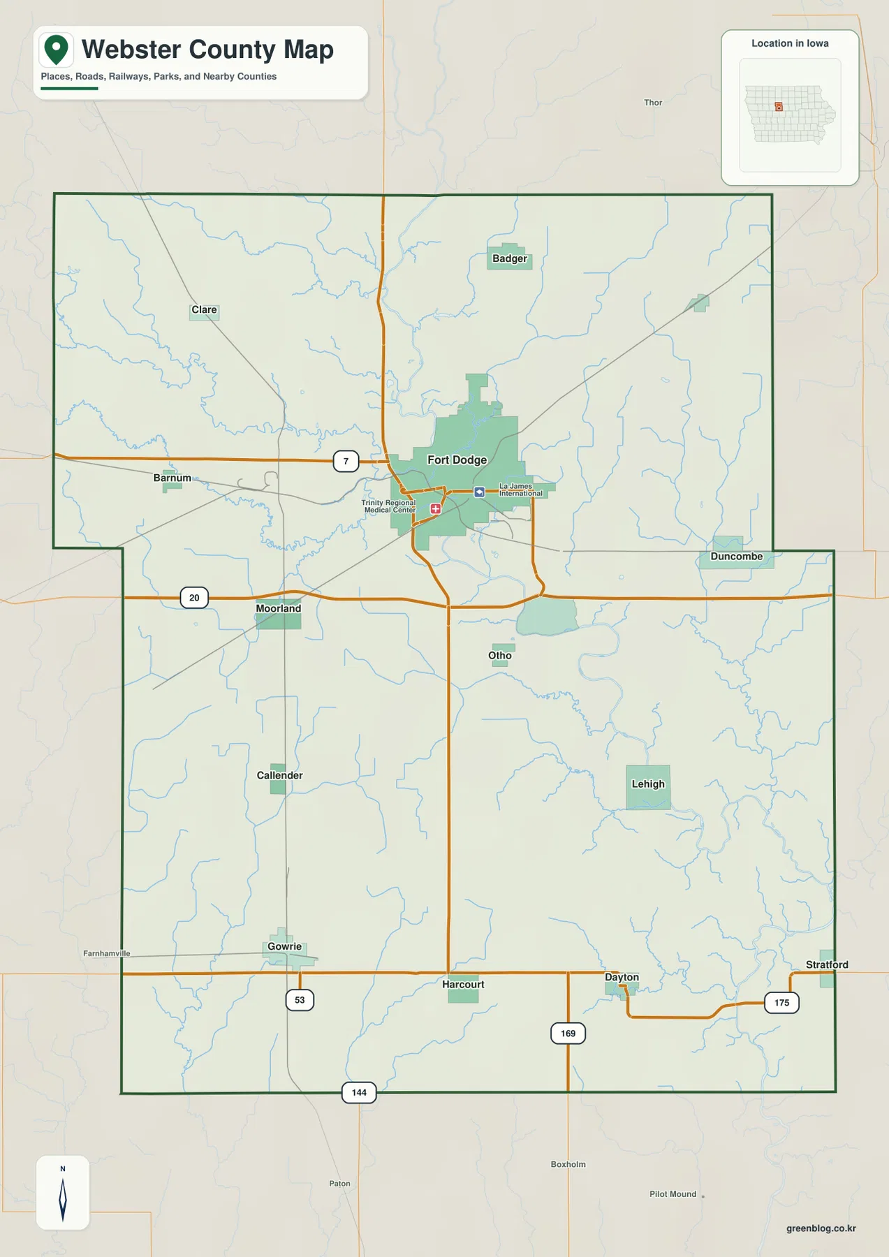
This map is designed for county-scale orientation. It can help answer questions such as whether Dayton lies southeast of Fort Dodge, where Badger sits relative to the urban area, or which major route crosses the southern half of the county. It should not be used to determine property lines, legal rights-of-way, construction elevations, or current road closures. Those tasks require official county parcel records, engineering information, or live transportation services. For general geographic reading, however, the combination of named places, roads, waterways, and the county outline provides a clear foundation for the more specialized layers below.
One large urban center and five smaller communities spread across the county
The city map simplifies Webster County to six ranked communities. Its index lists Fort Dodge at 24,827 people, Gowrie at 932, Dayton at 689, Badger at 433, Callender at 413, and Otho at 380. These are the values printed on the supplied graphic and are best used to compare relative size within the map. They are not a substitute for the latest Census estimate. What the graphic makes immediately clear is the scale difference between Fort Dodge and the other five places: the county has one dominant urban center surrounded by much smaller towns rather than several similarly sized cities.
Fort Dodge is also geographically well placed for that role. It occupies the north-central interior near the Des Moines River and several major road connections. Badger is north of the city, Otho lies south, and the remaining ranked communities are spread across the lower half. Callender is southwest of the center, Gowrie is farther south and west, and Dayton occupies the southeast. Large rural gaps separate these places, which is why the map reads as a set of distinct town points rather than a continuous urban corridor.
The city layer becomes more informative when the water map is kept in mind. Badger lies close to Badger Creek and Badger Lake. Fort Dodge is near the Des Moines River, Lizard Creek, and several smaller channels. Otho sits south of Fort Dodge near the part of the river system where the main valley begins to swing toward the southeast. Gowrie and Callender are farther from the principal river and closer to the higher southwestern uplands, while Dayton is surrounded by a finer network of southeastern tributaries. Those differences help explain why the six towns do not occupy identical physical settings.
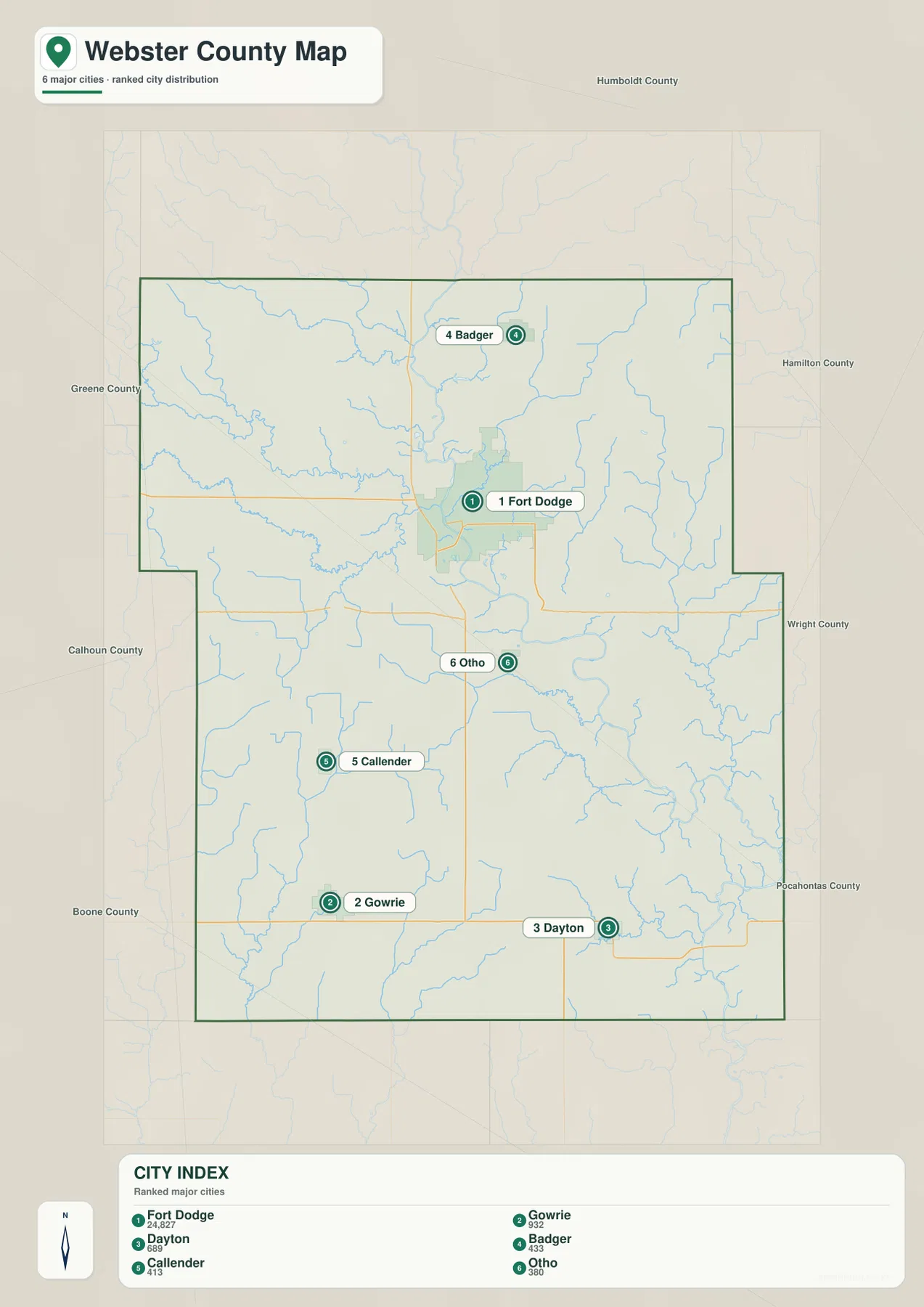
The ranking should not be read as a complete measure of local importance, services, or municipal function. It is a compact way to show settlement distribution. Current government information, population estimates, school boundaries, or service areas should be checked with the relevant local or state agencies. For map reading, the important point is placement: Fort Dodge sits north of the county’s midpoint, Badger extends the pattern northward, and Gowrie and Dayton stretch the urban references toward opposite sides of the southern half. That gives the reader a useful set of landmarks before moving into the river and terrain layers.
Lizard Creek, Soldier Creek, and Brushy Creek feed the Des Moines River system
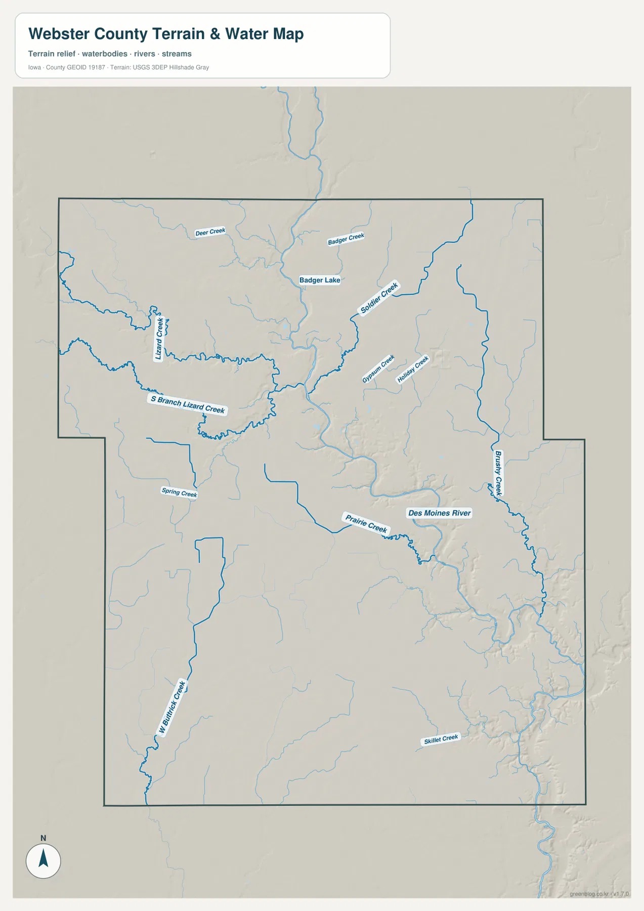
The water and terrain map is organized around the Des Moines River. The river enters near the northern center, runs toward the Fort Dodge area, and then follows a broad series of bends toward the southeast. Its valley is wide enough to stand out even before the elevation colors are considered. Smaller channels approach from both sides, giving the central and eastern parts of Webster County a branching pattern of low ground. That river network is one of the county’s most useful geographic features because it links the northern interior, Fort Dodge, and the southeastern landscape in one continuous line.
From the west, Lizard Creek and South Branch Lizard Creek form prominent winding channels that approach the main river near the Fort Dodge area. Their valleys are broader and more sinuous than many of the tiny unnamed streams around them. Farther north, Deer Creek, Badger Creek, and Badger Lake add a second cluster of water features. To the northeast, Soldier Creek descends toward the central river system. The supplied map therefore shows that northern Webster County is not simply flat agricultural land; it is divided by several recognizable creek valleys before those waters reach the Des Moines River.
East and south of Fort Dodge, the labels change but the same relationship continues. Gypsum Creek and Holiday Creek occupy the east-central area, Prairie Creek joins the drainage near one of the large river bends, and Brushy Creek forms a long corridor near the eastern side. West Buttrick Creek appears in the southwest, while Skillet Creek is labeled in the southeast. These channels differ greatly in size, yet together they explain much of the texture seen on the relief background. Narrow stream valleys cut into higher ground and create a landscape of ridges, shallow hollows, and occasional deeper river cuts.
The lower river valley near Lehigh provides a real-world example of the relief visible on the map. The Iowa Department of Natural Resources describes nearby Dolliver Memorial State Park as overlooking the Des Moines River Valley and notes its bluffs, wooded slopes, and distinctive geologic formations. The park boundary itself is not the subject of this county map, but the official description matches the broader physical pattern shown in the elevation layer: the main river has cut a noticeably lower corridor through the surrounding uplands. That contrast becomes especially clear as the river approaches the southeastern portion of the county.
This water layer is intended for geographic orientation rather than flood, navigation, or legal boundary decisions. Stream levels and access conditions change with weather and season, and mapped channels should not be treated as surveyed parcel boundaries. If the question involves current flooding, water quality, park access, or engineering work, use current information from USGS, Iowa DNR, Webster County, or another responsible agency. For general reading, the map is very effective at showing which towns lie near the main river, which areas are dominated by tributaries, and where low valleys cut across the road grid.
A 273–374 meter range reveals a deep river valley against higher western ground
The elevation map reports an actual range of about 273 to 374 meters with a mean near 343 meters. The roughly 100-meter spread is enough to create a strong visual contrast. Brown and darker tan areas mark the higher uplands, especially across much of the west and northwest, while green shades trace the lower Des Moines River valley and its tributaries. Fort Dodge sits close to that transition rather than on one uniform flat surface. River channels, side valleys, and higher interstream ground all occur within a relatively short distance of the city.
The main river valley is the clearest low feature. A green corridor enters from the north, tightens and bends through the central part of the county, and becomes especially pronounced toward the southeast. Where tributaries join, narrow green fingers extend outward into higher terrain. Lizard Creek cuts eastward from the western uplands, while Soldier Creek and Brushy Creek create lower branches on the eastern side. The result is a terrain pattern that resembles a branching network rather than a simple west-to-east slope.
Higher ground is broadest across the western half, where long brown ridges remain between creek valleys. Callender and Gowrie are closer to that higher landscape than Fort Dodge or Lehigh. The southwestern area is not a single flat plateau; small drainage lines repeatedly break it into rolling sections. Around Dayton in the southeast, the terrain is lower and more dissected by tributaries than the broad western uplands, although it still stands above the deepest parts of the Des Moines River corridor. These local differences are easy to miss on the road map but become obvious once the elevation colors are added.
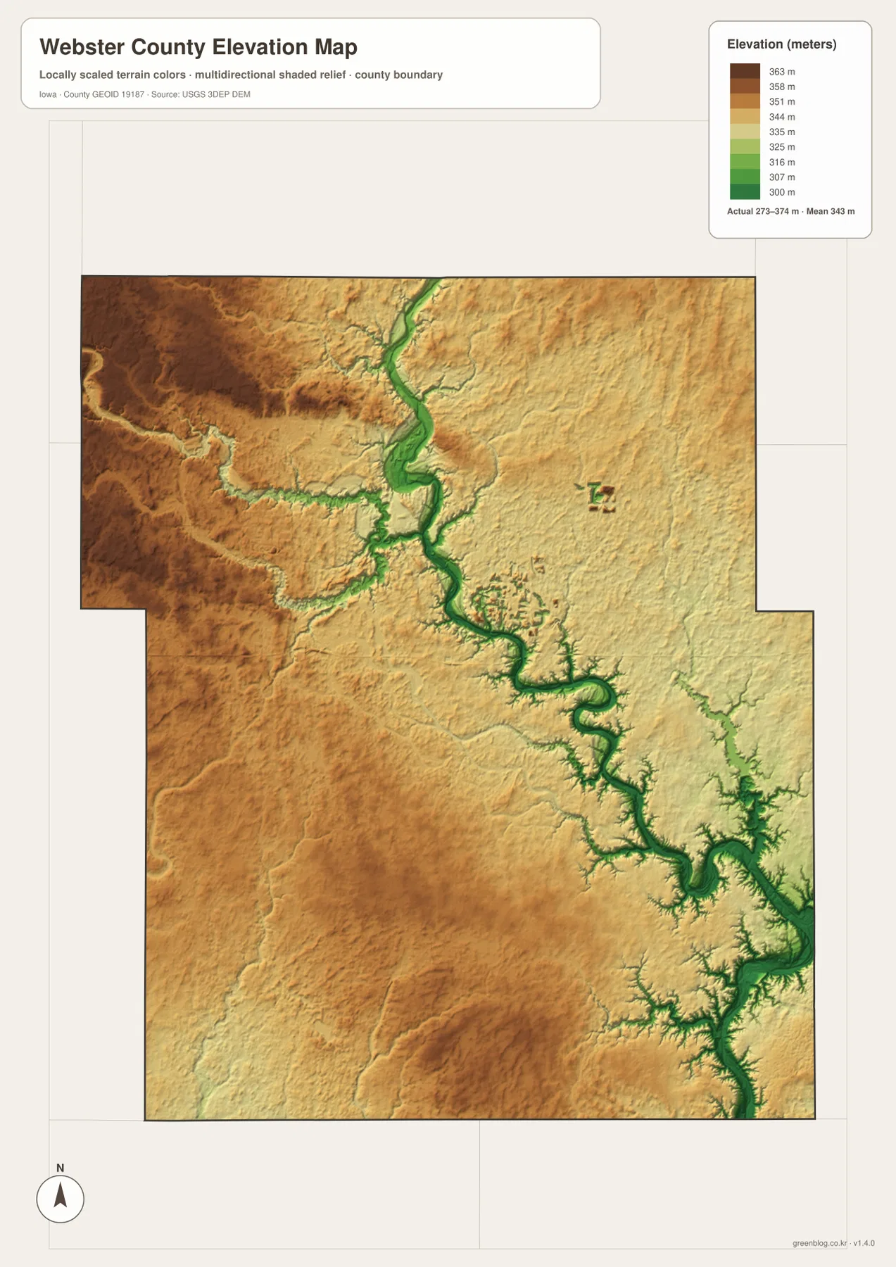
The elevation layer is a county-scale reference, not a survey product. It is useful for comparing higher ridges with lower stream valleys and for understanding why certain river corridors stand out so strongly. It should not be used to determine the exact elevation of a building site, calculate drainage grades, design roads, or establish construction levels. Those tasks require site-specific surveying and engineering data. On this page, the most useful reading is comparative: the west is generally higher, the Des Moines River occupies the deepest continuous lowland, and tributaries cut smaller valleys into the surrounding uplands.
Reading Fort Dodge, Badger, Gowrie, and Lehigh across the same landscape
For Fort Dodge, begin with the general map and locate Iowa 7, U.S. 169, and the urban footprint. Then move to the water layer and find the Des Moines River, Lizard Creek, and the smaller east-side tributaries. The elevation layer completes the picture by showing the city close to a low river corridor with higher ground on both sides. Following one place through the maps in this order makes the information easier to retain than reading four separate descriptions without a common landmark.
Badger offers a different comparison. The city layer places it north of Fort Dodge, but the water layer adds Badger Creek and Badger Lake to that simple directional relationship. The elevation map shows a number of narrow low channels around the northern area rather than one broad continuous flat. Gowrie and Callender, by contrast, sit farther southwest on generally higher ground and farther from the Des Moines River trunk. Those distinctions make the smaller communities useful reference points for understanding the county’s physical variety, not just its settlement pattern.
Dayton and Lehigh help explain the southeast. Dayton is one of the six ranked towns and lies among several tributary valleys, while Lehigh appears on the general county map near the deeply cut Des Moines River corridor. The elevation layer makes the difference obvious: the river valley near Lehigh is one of the county’s lowest and most sharply defined features, whereas Dayton is surrounded by smaller, more branching lows. The nearby Dolliver Memorial State Park information from Iowa DNR gives additional context for the bluffs and river-valley scenery associated with this part of Webster County.
If you plan to print the maps or inspect small labels, the original JPG files in the ZIP are more useful than the web previews. The general county map is best for town and highway orientation. The city map provides a quick settlement comparison. The water layer is the clearest choice for identifying named creeks and the Des Moines River, and the elevation layer works well when the goal is to compare ridges with low valleys. Using a single town or river bend as a reference point across the files is the easiest way to keep the different layers aligned.
Frequently Asked Questions
Which map is best for comparing Fort Dodge and Gowrie?
Start with the general county map because it shows both communities together with the main numbered roads. Fort Dodge is the large north-central urban area, while Gowrie is in the southwestern part of the county. The elevation layer adds an important difference: Fort Dodge is close to the low Des Moines River corridor, whereas Gowrie is associated with broader higher ground in the southwest. Use current navigation tools for exact driving distance, travel time, and road conditions.
How does the Des Moines River cross Webster County?
On the supplied water map, the river enters near the northern center, passes the Fort Dodge area, and then follows a series of bends toward the southeast. Lizard Creek, Soldier Creek, Prairie Creek, and other tributaries connect to the larger system. The same corridor appears in green on the elevation map because it lies lower than the surrounding uplands. For current river stage, flooding, or water conditions, check USGS and local official sources rather than relying on this static map.
Can the 273–374 meter elevation map be used for surveying or construction?
No. The elevation map is intended to compare county-scale terrain, such as the higher western uplands and the lower Des Moines River valley. It does not provide surveyed parcel elevations, legal boundaries, construction grades, or engineering measurements. Site planning, drainage design, road work, and property decisions require current survey data and official engineering or county records.
Map File Information
The ZIP contains high-resolution JPG files matching the Webster County general, city, water, and elevation maps shown on this page.
- Included Files: Use only the versions confirmed in the article and supplied images
- File Type: Use the confirmed download contents
- Intended Use: Printing, education, presentations, and map-based projects
Related Maps
Sources and references
These official sources provide additional information about Webster County, transportation maps, the Des Moines River landscape, boundaries, hydrography, and elevation data.
- Webster County, Iowa official website – county government and local information
- Iowa DOT Webster County Maps – county and city road-map resources
- Iowa DNR: Dolliver Memorial State Park – natural and park information for the Des Moines River Valley near Lehigh
- U.S. Census Bureau TIGER/Line – administrative boundaries and transportation geography
- USGS National Hydrography – rivers, streams, and water features
- USGS 3D Elevation Program – elevation data
Green Map creates custom-edited map images using open geographic data sources such as geoBoundaries, Natural Earth, OpenStreetMap, and government open data.
These maps are edited visual materials, not raw data files, and are provided for education, documents, presentations, and graphic reference.