Warren County sits in south-central Iowa, immediately south of the Des Moines metropolitan area. Indianola is the county seat and the main central reference point, while Norwalk, Cumming, Carlisle, and Hartford form a more closely spaced group of communities across the northern part of the county. Farther south, Milo, New Virginia, and Lacona are separated by broader rural areas. The maps on this page combine towns, highways, streams, lakes, and terrain so you can see how those pieces fit together, and the matching high-resolution JPG map files are available as a downloadable ZIP.
The official Warren County website lists Indianola as the county seat and reports a 2020 census population of 52,403. That central role is easy to recognize on the maps: Iowa 92 runs east-west through Indianola, while north-south routes converge near the city. The northern edge looks different because it transitions toward the Des Moines urban area, with Norwalk and Cumming to the northwest and Carlisle to the north. This contrast between a more urbanized north and a more widely spaced rural south is one of the most useful patterns to keep in mind while reading the county.
A practical way to orient yourself is to use Indianola, the Des Moines River along the northeastern side, and Lake Ahquabi south of Indianola as three anchor points. From there, the road map helps locate communities, the city map simplifies the settlement pattern, the water map follows tributaries and lakes, and the elevation map reveals the ridges and valleys that are not obvious on a standard road view. Reading the maps together makes the county easier to understand without treating any single layer as a complete navigation, flood, or survey product.
Table of Contents
Indianola at the center of the road network and the northern metro edge
On the general county map, Indianola stands near the middle of Warren County at a clear road junction. Iowa 92 crosses the county from west to east through the city, while U.S. 65 and U.S. 69 provide the main north-south reference through the central area. Iowa 28 runs farther west through the Norwalk and Martensdale side of the county, and Interstate 35 hugs the western edge before continuing north toward the Des Moines metro. These routes make the central and northern parts of Warren County much easier to place in relation to one another.
The northern tier contains a tighter cluster of named communities. Norwalk and Cumming lie in the northwest, Carlisle is near the north-central edge, and Hartford sits farther east near the network of streams leading toward the Des Moines River. The map also labels West Des Moines and Des Moines just beyond or along the northern context, and Warren County’s official cities page includes both Des Moines and West Des Moines among the cities represented in the county. That northern pattern contrasts with the wider spacing between communities in the southern half.
South of Indianola, the road network opens into a more rural landscape. Milo appears southeast of the county seat, New Virginia is in the southwest, and Lacona is close to the southeastern corner. Ackworth and Sandyville sit near the east-west Iowa 92 corridor east of Indianola, so that highway provides a useful visual line for locating several smaller communities. The county map is especially helpful for comparing these places because it shows them in the same frame as the larger northern cities and the roads connecting the county to neighboring areas.
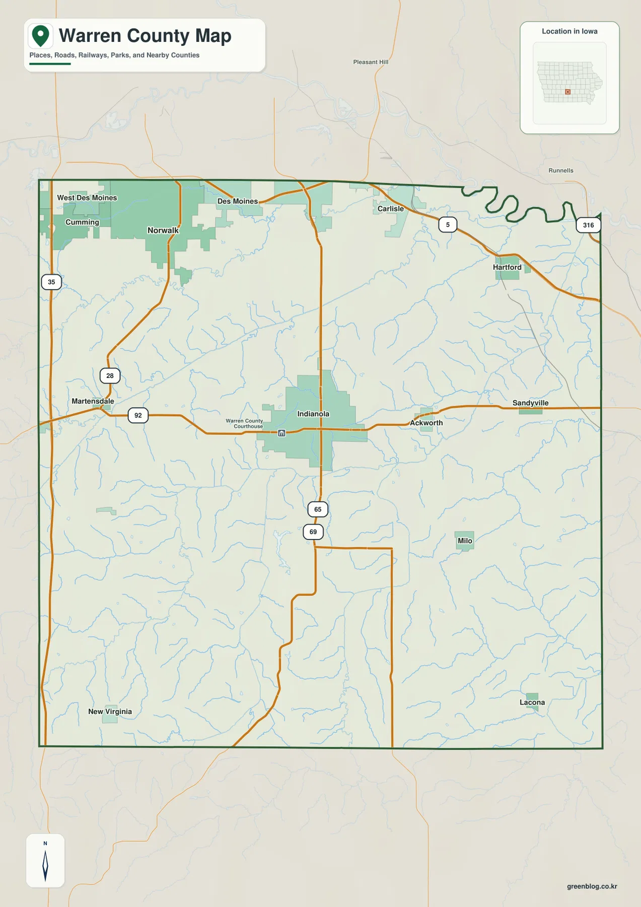
Use this map as an orientation reference rather than a legal boundary, parcel, or turn-by-turn navigation product. It is well suited to finding the relative positions of Indianola, Norwalk, Carlisle, Hartford, Milo, New Virginia, and nearby road corridors. For an actual driving trip, current road conditions and detailed intersections should be checked with a navigation service. For understanding where the county’s communities sit before moving to the water and terrain views, however, this is the most straightforward starting point.
A city pattern that shifts from the north to the rural south
The city map reduces the county to six ranked communities, making the settlement pattern easier to compare. Indianola is shown as the largest city in the set and occupies the central position. Norwalk is second and lies much farther north, close to the Des Moines metro edge. Carlisle is also in the north, Hartford is northeast, Milo is southeast, and New Virginia is southwest. With most of the labeled population concentrated in Indianola and the northern tier, the visual gap between those places and the smaller southern communities becomes immediately apparent.
The city index printed on the supplied map lists Indianola at 16,044, Norwalk at 14,183, Carlisle at 4,255, Hartford at 760, Milo at 731, and New Virginia at 587. These figures are part of the map’s prepared city index and are best used to understand relative scale within this specific graphic rather than assumed to be the newest official population estimates. For current demographic statistics, the U.S. Census Bureau should be consulted directly. Within the map, the values help explain why Indianola and Norwalk dominate the visual hierarchy while the southern towns appear as smaller centers.
Norwalk’s position is particularly useful for understanding Warren County’s northern growth corridor. It is geographically separated from Indianola by a broad area of smaller roads and drainage lines, yet it sits close to the metropolitan context at the top of the map. Carlisle and Hartford occupy the northeastern side near the Des Moines River system, while Milo and New Virginia are set among a more widely spaced network of streams and rural roads. The city map therefore works less like a street map and more like a quick comparison of where the county’s larger settlement centers are located.
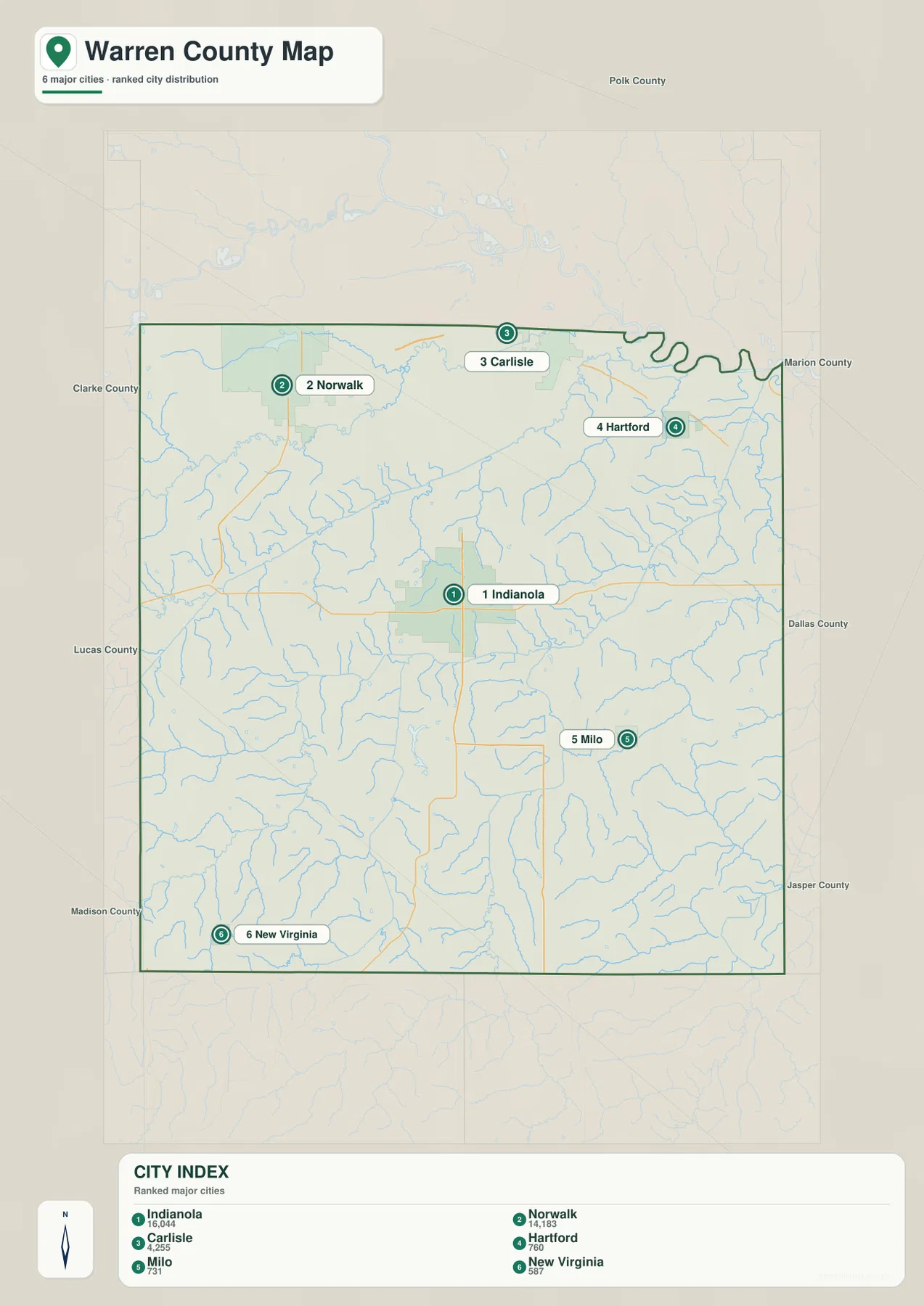
This city view does not calculate driving distance or travel time, and it should not be used to infer the fastest route between communities. Its strength is showing direction and spacing. A visitor can quickly see that Norwalk and Carlisle belong to the northern part of the county, Indianola occupies the middle, and Milo and New Virginia sit deeper in the southern half. When paired with the general road map, it becomes easier to connect those positions with Iowa 92, Iowa 28, U.S. 65, U.S. 69, and Interstate 35.
Des Moines River tributaries and Lake Ahquabi shape the water map
The water and terrain map is dominated by the broad bends of the Des Moines River near the northeastern side of Warren County. Inside the county, the North River and South River form major drainage references, while smaller named streams such as Middle Creek, Cavitt Creek, Shrimpy Creek, Short Creek, Coal Creek, Turkey Creek, and Wolf Creek branch across the landscape. Because shaded terrain is included behind the water lines, the map makes it easier to see that streams occupy lower valleys rather than running across a perfectly flat surface.
Around Indianola, smaller tributaries radiate through the central portion of the county and eventually connect with larger river systems. The South River crosses the southern half, while Coal Creek and Wolf Creek stand out in the eastern and southeastern areas. North River and Middle Creek help organize the northern drainage. These waterways are useful geographic markers because they divide the rolling uplands into a series of ridges and valleys, a pattern that becomes even clearer when you compare the same locations on the elevation map.
Lake Ahquabi is one of the most recognizable water features south of Indianola. The Iowa Department of Natural Resources identifies Lake Ahquabi State Park as a Warren County park and notes that it was dedicated in 1936, with Civilian Conservation Corps-era stone structures still associated with the site. On the supplied map, Lake Ahquabi provides a convenient landmark for the south-central part of the county. Lake George appears farther west, and Colchester Lake is marked toward the northwest, adding smaller water references beyond the river and creek network.
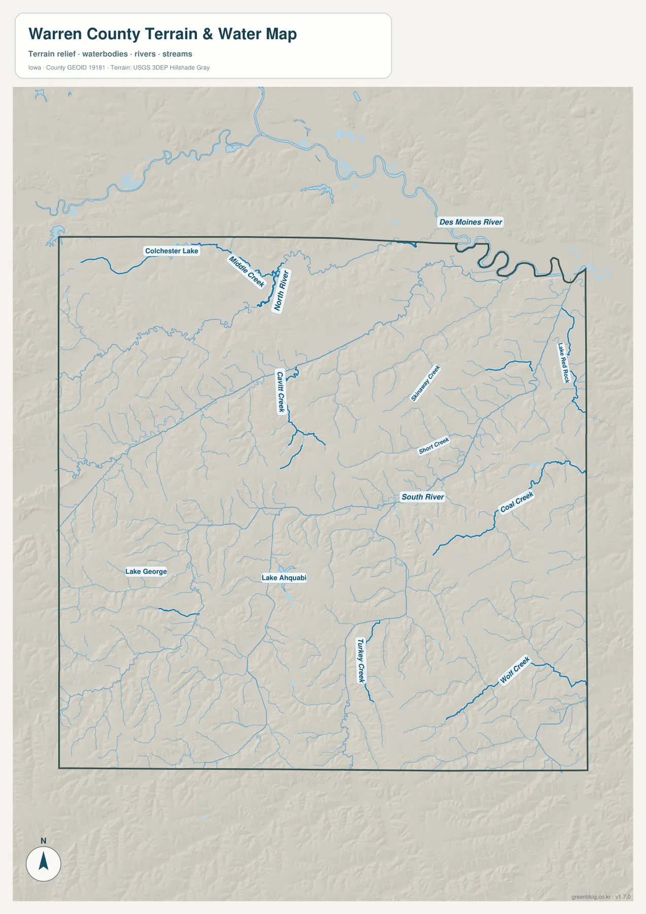
This is a geographic water-reference map, not a flood-hazard, water-quality, parcel, or boating-navigation product. Stream positions can help explain the shape of valleys and the relationship between towns and terrain, but floodplain limits and current water conditions must be checked with the appropriate official agency. The map is most valuable when used alongside the road and elevation views: it shows where the low corridors are, while the other maps show what communities and routes sit around them.
Elevation rises across the west and southwest between stream valleys
The elevation map covers an approximate range of 228 to 335 meters and displays a mean of 277 meters. Warren County is not mountainous, but the shaded surface makes its rolling terrain easy to see. The western and especially southwestern areas contain more tan and brown higher ground, while lower green corridors follow the major valleys. The northeastern side near the Des Moines River is generally lower, matching the broad river setting visible on the water map.
In the southwest, higher ridges are repeatedly cut by narrow stream valleys, producing a textured landscape rather than one continuous upland. Similar but somewhat lower ridges appear through the central and eastern parts of the county. Green valley floors associated with the North River, South River, and their tributaries thread between those ridges. This arrangement helps explain why a straight line between two nearby places may cross several small rises and depressions even though the county looks relatively gentle on a standard road map.
The map also clarifies the relationship between drainage and elevation. Streams tend to occupy the lower green bands, while the ground between them rises into yellow, tan, and brown ridges. Lake Ahquabi sits within this rolling south-central terrain, and the western side of the county shows some of the stronger local relief. These are broad terrain patterns derived from an elevation surface, not surveyed spot heights for individual properties. Engineering, construction, drainage design, and precise site work require authoritative survey data.
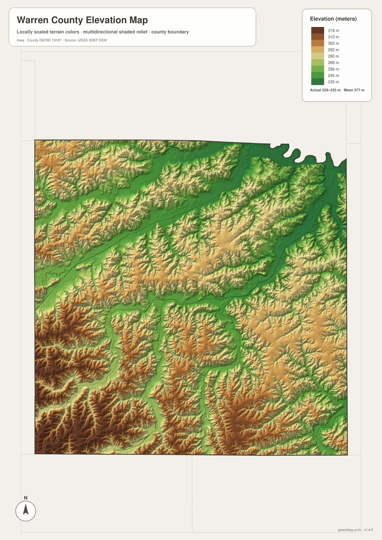
Comparing the elevation and water maps is one of the best ways to understand the county. The Des Moines River and its tributary corridors align with lower terrain, while the western and southwestern uplands stand out above them. Indianola occupies a central zone surrounded by a mix of gentle ridges and drainage lines, while the northern communities sit closer to the lower river network and the metropolitan edge. The southern towns are spaced across more extensive rolling terrain, which helps give the lower half of the county a different visual character.
Choosing the right Warren County map for the task
Start with the general county map when you need city names, highways, and a broad boundary reference. Use the city map when the main question is where Indianola, Norwalk, Carlisle, Hartford, Milo, and New Virginia sit relative to one another. The water map is the best choice for the Des Moines River, North River, South River, Lake Ahquabi, and named creeks. The elevation map is most useful when you want to see how higher western and southwestern ridges contrast with lower stream valleys.
For example, someone studying Indianola can first locate Iowa 92 and the north-south highways on the general map, then switch to the water map to see nearby tributaries and finally use the elevation view to compare the surrounding ridges and valleys. For Norwalk and Carlisle, the maps make the northern metropolitan transition and proximity to the Des Moines River system easier to understand. Around Milo and New Virginia, the wider spacing of communities and the repeated pattern of small valleys becomes more noticeable when the terrain layers are added.
The downloadable archive is useful when you want to keep the maps offline or inspect the labels at a larger size. It contains the original high-resolution JPG versions corresponding to the county, city, water, and elevation maps shown on the page. The WebP images in the article are optimized for quick viewing, while the JPG files are more convenient for zooming, personal reference, or printing. Each map emphasizes a different type of information, so it is worth choosing the one that matches the question rather than treating all four as interchangeable.
Frequently Asked Questions
Which map best shows how Indianola relates to the Des Moines metro area?
The general county map is the clearest starting point. Indianola sits near the middle of the county, while Norwalk, Cumming, and Carlisle are farther north and the map provides context toward Des Moines and West Des Moines. Interstate 35, Iowa 28, Iowa 92, U.S. 65, and U.S. 69 help show how the central county connects with the northern metropolitan edge. Use a current navigation service separately when you need actual driving routes or travel times.
Which map should I use to compare Lake Ahquabi with the Des Moines River?
Use the water and terrain map. It places Lake Ahquabi south of Indianola while the Des Moines River forms a major reference along the northeastern side, and it also labels the North River, South River, and several smaller creeks between them. Pairing that map with the elevation view makes it easier to see how the river and tributary valleys sit below the surrounding rolling uplands.
Can the 228–335 meter elevation map be used for engineering or property surveying?
No. The elevation layer is a generalized surface intended to show relative high and low ground across the county. It is useful for identifying broad ridges, valleys, and the relationship between drainage and terrain, but it is not survey-grade elevation data for a specific parcel. Construction, drainage design, engineering, and boundary work should rely on official survey and site-specific measurements.
Map File Information
The ZIP contains high-resolution JPG files corresponding to the Warren County general, city, water, and elevation maps shown on this page.
- File Type: ZIP containing 4 JPG files
Related Maps
Sources and references
These official resources provide county information and the underlying types of boundary, water, and elevation data useful for checking the map context.
- Warren County official website – county seat and community information
- Warren County Cities – official list of cities represented in the county
- Iowa DNR: Lake Ahquabi State Park – official park and lake context
- U.S. Census Bureau TIGER/Line – geographic boundary and transportation data
- USGS National Hydrography – rivers, streams, and water features
- USGS 3D Elevation Program – elevation data
Green Map creates custom-edited map images using open geographic data sources such as geoBoundaries, Natural Earth, OpenStreetMap, and government open data.
These maps are edited visual materials, not raw data files, and are provided for education, documents, presentations, and graphic reference.