Dickinson County in northwestern Iowa stands out because water shapes the county more visibly than it does in many other parts of the state. Spirit Lake, East Okoboji Lake, and West Okoboji Lake form a large central lake district, with Spirit Lake, Okoboji, Arnolds Park, and Milford arranged around or just south of those waters. Lake Park and Silver Lake sit farther west, while Little Spirit Lake marks the northern edge of the county’s water landscape. Iowa 9 provides an east–west reference across the northern part of the county, U.S. 71 runs through the central lake communities, and Iowa 86 follows the west side of the West Okoboji area. This page uses the supplied maps to explain the towns, roads, lakes, streams, and terrain, including an elevation range of 407 to 482 meters. High-resolution JPG versions of all four maps are available in the download section below.
The easiest way to understand Dickinson County is to begin with the lakes rather than with the county boundary alone. Spirit Lake anchors the north-central area, while East and West Okoboji lakes extend the water-focused landscape south toward Arnolds Park and Milford. The towns are easier to remember when they are tied to these recognizable water bodies: Spirit Lake lies just south of its namesake lake, Okoboji sits between the central lakes, and Arnolds Park occupies the southern part of the lake district. Lake Park forms a separate western reference near Silver Lake. When the water and elevation maps are compared, the lake basins and river valleys appear lower than many of the surrounding ridges, creating a terrain pattern that is much more varied than a simple flat plain.
Table of Contents
Using Spirit Lake and the Okoboji lakes as the main landmarks
The county overview is dominated by the large chain of lakes in the middle of Dickinson County. Spirit Lake occupies the northern part of that system, followed by the long shapes of East Okoboji Lake and West Okoboji Lake farther south. Spirit Lake serves as the primary settlement and road reference in the north-central area. Okoboji lies close to the narrow land between the two Okoboji lakes, Arnolds Park sits farther south along the lake district, and Milford marks the transition from the lake communities into the southern part of the county.
Several smaller communities add useful reference points around the edges of the lake district. Orleans is positioned beside the eastern side of Spirit Lake, while Wahpeton and West Okoboji are associated with the western and southwestern side of West Okoboji Lake. Lake Park is well to the west near Silver Lake, separating it clearly from the central cluster. Superior appears near the eastern side of the county, and Terril lies farther southeast. Together, these places show that Dickinson County is not organized around a single compact urban center; instead, settlements are distributed around major lakes and across the surrounding rural landscape.
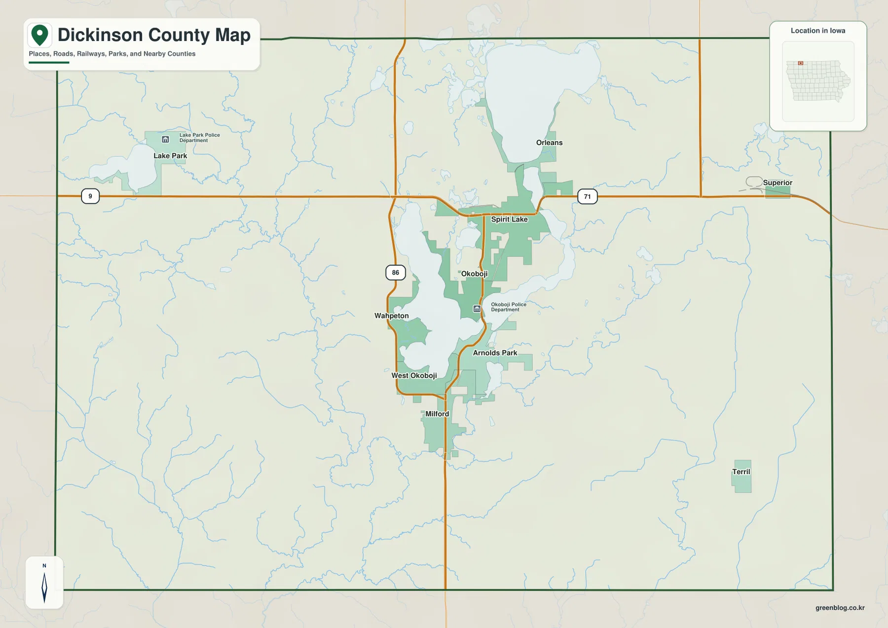
For road orientation, three routes provide a simple framework. Iowa 9 crosses the northern part of the county and helps connect the Lake Park side with the Spirit Lake area. U.S. 71 runs through the central lake corridor, linking the Spirit Lake, Okoboji, Arnolds Park, and Milford sequence. Iowa 86 follows the western side of West Okoboji Lake and is useful for locating Wahpeton and West Okoboji. These routes are shown for geographic orientation; current road closures, construction, and turn-by-turn travel should be checked with a live navigation or transportation source.
How Spirit Lake, Milford, Lake Park, and the lake towns are distributed
The city map highlights six major communities: Spirit Lake, Milford, Lake Park, Okoboji, Arnolds Park, and Orleans. Spirit Lake is the main north-central reference, and Milford is the southern anchor of the central settlement corridor. Lake Park is separated from that cluster on the western side of the county. Okoboji and Arnolds Park are tightly associated with the central lakes, while Orleans sits just north and east of Spirit Lake along the shore area.
This arrangement is easier to understand as a set of zones rather than as a simple north-to-south line. The central lake district contains several communities within a relatively compact area, while Lake Park forms a distinct western node. Okoboji and Arnolds Park occupy the narrow spaces around the Okoboji lakes, where water defines the shape of the developed area. Orleans sits beside Spirit Lake, and Milford is farther south where the landscape opens beyond the main lake chain. Once these six places are familiar, the county overview becomes much easier to read because the roads and lake names can be attached to known settlement points.
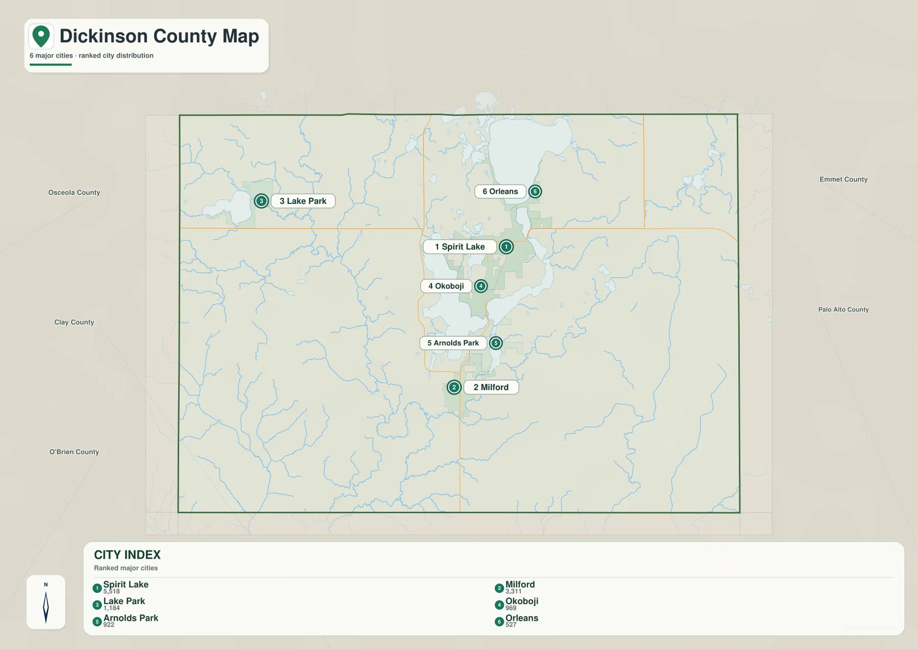
Communities beyond the six highlighted locations help define the county’s full extent. Superior provides an eastern reference away from the central lakes, and Terril marks the southeastern portion of the county. Wahpeton and West Okoboji remain closely tied to the west side of West Okoboji Lake. These locations are useful when switching between the city map and the water map because they show which places belong to the lake district and which are better understood as rural or outer-county settlements.
Spirit Lake, East and West Okoboji, and the surrounding water network
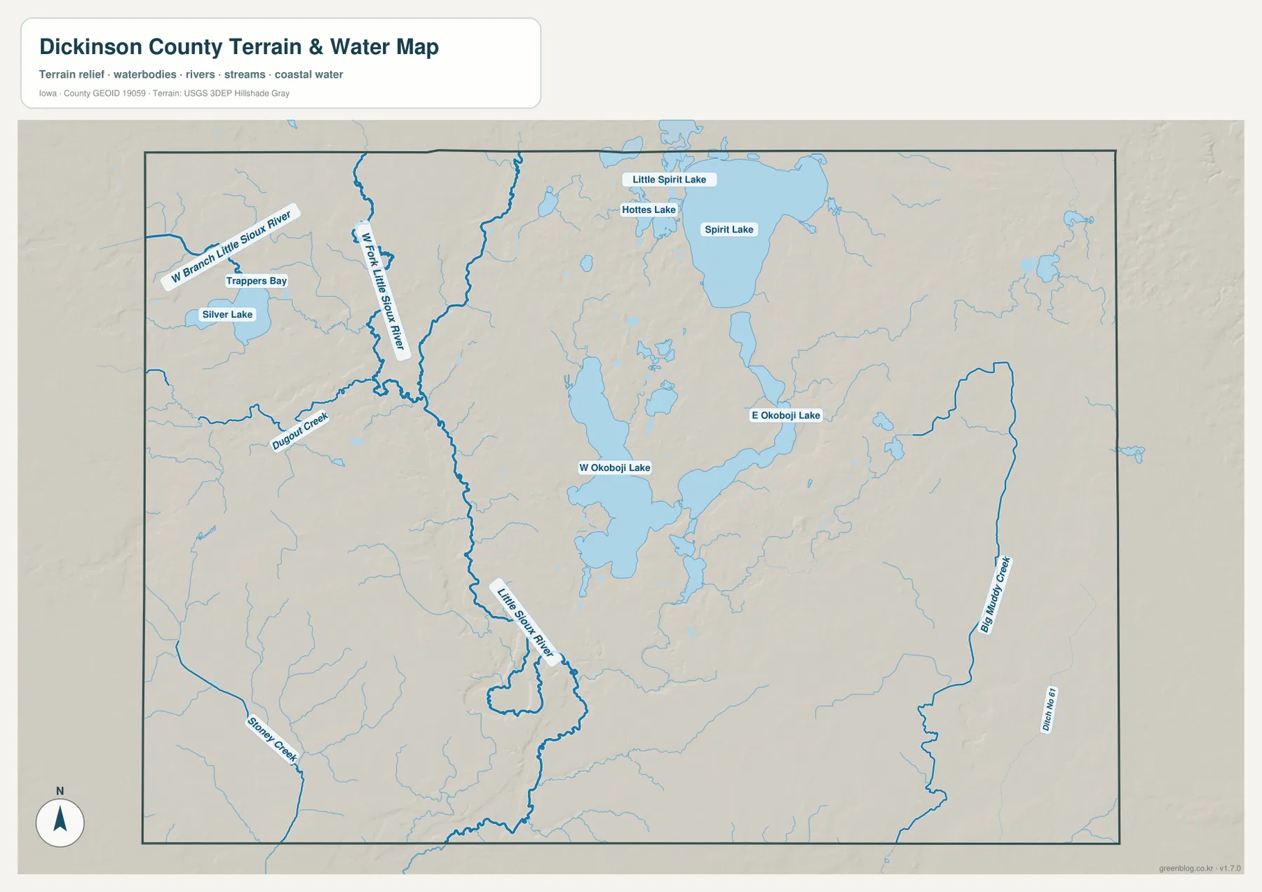
The terrain-and-water map makes the central lake system the defining feature of Dickinson County. Spirit Lake is the largest northern water body, with East Okoboji Lake and West Okoboji Lake forming the main southern pair. Their shapes are quite different, and the narrow land between them creates a complex shoreline pattern around Okoboji and Arnolds Park. Little Spirit Lake appears near the northern boundary, and Hottes Lake is shown just south of it, adding smaller water landmarks above the main lake district.
Western Dickinson County has a different water pattern. Silver Lake and Trappers Bay are the most obvious named waters near Lake Park, while the West Branch Little Sioux River and West Fork Little Sioux River run southward through the western half of the county. Farther south, the Little Sioux River system continues through a broader low corridor. Dugout Creek and Stoney Creek add smaller tributary valleys that help explain why the western terrain is divided into many ridges and drainage lines rather than one broad, smooth surface.
On the eastern side, Big Meadow Creek forms a long drainage feature separate from the lake district. That contrast matters because it shows that Dickinson County’s water geography is not limited to the well-known lakes. Large lakes, river branches, and smaller creeks all contribute to the county’s terrain. Looking beyond the central water bodies reveals a wider network of valleys and drainage corridors extending through the rural parts of the county.
Elevation from 407 to 482 meters around the lake basins
The supplied elevation map gives Dickinson County an actual range of about 407 to 482 meters, with a mean elevation of 442 meters. Lower green terrain is prominent around Spirit Lake and the Okoboji lakes, where water occupies broad basins and connected low areas. Higher yellow, orange, and brown ground appears on ridges outside the central lake district. A large elevated area is visible east of the lakes, while additional higher terrain appears toward the western and southwestern parts of the county.
The contrast is not a simple step from low lakes to uniformly high uplands. Narrow valleys extend away from the water bodies, and small streams cut through the surrounding terrain. The Little Sioux River system creates a lower corridor in the western half of the county, while the eastern uplands are also divided by drainage lines. Even between East and West Okoboji lakes, small ridges and changes in relief remain visible. Comparing the elevation map with the water map is therefore more useful than looking only at the minimum and maximum numbers.
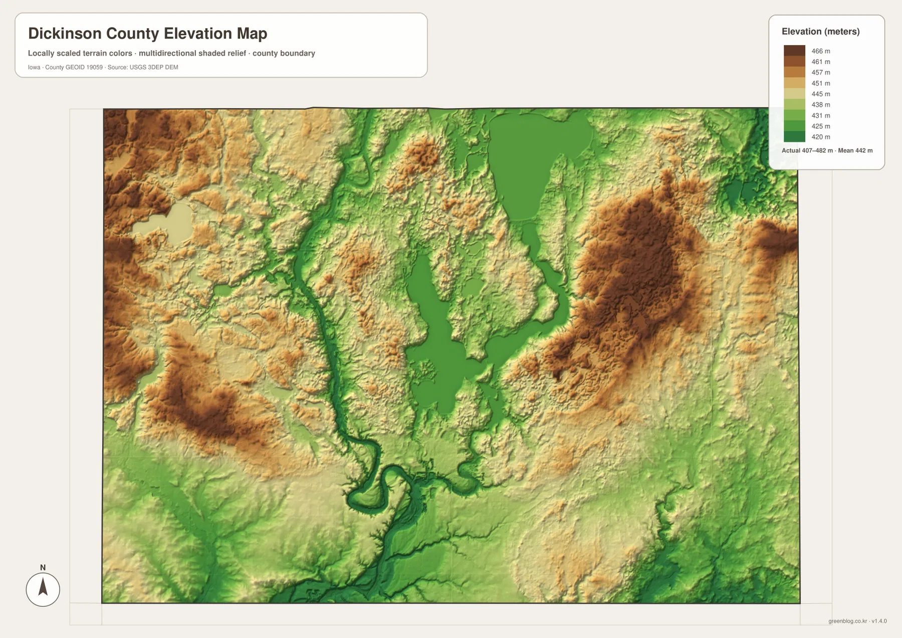
This elevation surface is intended for county-scale comparison rather than precise measurement at a property or structure. A single color band covers a range of elevations, and local slopes can change quickly near lake shores and stream valleys. Surveying, construction, drainage design, or other work that depends on exact elevation values should use the original USGS elevation data or professional measurements. For this page, the map is most useful for showing how the lakes and river valleys sit within the surrounding rolling terrain.
Connecting roads to the lake district
Road orientation in Dickinson County becomes much easier when the lakes are used as fixed landmarks. Spirit Lake city sits immediately south of Spirit Lake, and U.S. 71 continues through the central corridor toward Okoboji, Arnolds Park, and Milford. Iowa 86 tracks the west side of West Okoboji Lake, making Wahpeton and West Okoboji easier to place. Iowa 9 provides the northern east–west reference and helps connect the Lake Park side of the county with the Spirit Lake area.
Lake Park is particularly easy to remember when it is paired with Silver Lake rather than with the central lake cluster. Orleans is tied closely to Spirit Lake, while Okoboji and Arnolds Park are defined by the narrow land around East and West Okoboji lakes. Milford is south of the main lake district and works as a reference for the transition into the county’s southern rural area. Linking each town to one road or water feature is more useful than memorizing names without a geographic anchor.
Reading western Dickinson County through Silver Lake and the Little Sioux system
The central lakes receive most of the visual attention, but western Dickinson County has a separate terrain pattern. Silver Lake and Trappers Bay provide fixed landmarks near Lake Park, while the West Branch and West Fork of the Little Sioux River descend through the western half of the county. These waterways occupy distinct valleys rather than simply draining directly from the Okoboji lake system. On the elevation map, the same corridors appear as lower green strips between higher ridges.
Dugout Creek and Stoney Creek are smaller features, but they make the western relief easier to explain. Each tributary cuts into the uplands and divides broad higher areas into narrower ridges. This is why the western side of the county looks textured on the elevation map rather than uniformly high. The combination of Silver Lake, river branches, creeks, and rolling ground gives this part of Dickinson County a distinct character that is different from the central chain of large lakes.
Choosing the right Dickinson County map
For basic orientation, start with the county overview and locate Spirit Lake, the Okoboji lakes, Iowa 9, U.S. 71, and Iowa 86. Those features provide enough structure to place the main lake communities and understand the county boundary. If the goal is to compare settlements, the city map is cleaner because it emphasizes Spirit Lake, Milford, Lake Park, Okoboji, Arnolds Park, and Orleans without as much road detail.
For water geography, begin with Spirit Lake and the East and West Okoboji lakes, then move west to Silver Lake and the Little Sioux River branches. For terrain, use the 407-to-482-meter elevation scale to compare the low lake basins and river valleys with the higher eastern, western, and southwestern ridges. It is usually easier to study one question at a time and then use a second map for context rather than trying to extract every detail from all four maps at once.
The WebP images in the article are optimized for web viewing. The ZIP below contains high-resolution JPG copies of the county overview, major-city, terrain-and-water, and elevation maps for printing, classroom material, presentations, or closer inspection. They are general-reference maps and should not be used as substitutes for legal boundary records, parcel data, live road conditions, flood information, or survey-grade elevation measurements.
Frequently Asked Questions
Which map is best for locating Spirit Lake and the Okoboji lake communities?
Start with the county overview because it places Spirit Lake, East and West Okoboji lakes, the main towns, and the principal roads on one map. U.S. 71 provides the central north–south reference through the lake communities, while Iowa 9 and Iowa 86 help with the northern and western sides. Use the water map next if shoreline shapes and connected water bodies are the main interest.
What major lakes and rivers are shown on the Dickinson County water map?
The supplied map labels Spirit Lake, East Okoboji Lake, West Okoboji Lake, Little Spirit Lake, Hottes Lake, Silver Lake, and Trappers Bay. It also shows the West Branch and West Fork of the Little Sioux River, the Little Sioux River, and smaller streams such as Dugout Creek, Stoney Creek, and Big Meadow Creek.
What does the 407–482 meter elevation range show?
The elevation map shows lower terrain around the lake basins and major river valleys, with higher ground on ridges east of the central lakes and in parts of the west and southwest. The mean elevation is 442 meters. These values are useful for county-scale comparison, while exact elevations for properties, engineering, or surveying require original elevation data or professional measurement.
Map File Information
The ZIP contains high-resolution JPG versions of the Dickinson County overview, major-city, terrain-and-water, and elevation maps.
- Included Files: Use only the versions confirmed in the article and supplied images
- File Type: Use the confirmed download contents
- Intended Use: Printing, education, presentations, and map-based projects
Related Maps
Sources and reference data
The official resources below are useful for checking county boundaries, hydrography, and elevation data. The maps on this page are simplified for regional understanding, so tasks that require precise geometry or measurement should use the original datasets.
These maps are intended for general orientation, learning, printing, and presentation use. Legal boundaries, ownership, current road conditions, water levels, flood hazards, and precise elevations should be checked against the responsible agency’s current records and appropriate professional data.
Green Map creates custom-edited map images using open geographic data sources such as geoBoundaries, Natural Earth, OpenStreetMap, and government open data.
These maps are edited visual materials, not raw data files, and are provided for education, documents, presentations, and graphic reference.