Delaware County in northeastern Iowa is organized around Manchester, a set of smaller communities, and a landscape cut by many creek and river valleys. On the county overview, U.S. 20 provides a clear east–west reference from the Masonville side through Manchester toward Delaware and Earlville. Iowa 13 drops south from the Manchester area toward Ryan, while the northern part of the county includes Edgewood, Greeley, and Colesburg. Hopkinton sits in the southeast near Iowa 38. The maps on this page add the Maquoketa River system, the Little Turkey River, several named lakes and ponds, and an elevation range of 234 to 368 meters. The WebP images are designed for quick on-page viewing, and the download box below provides high-resolution JPG copies in a ZIP file.
The county becomes much easier to understand when roads, settlements, water, and relief are compared instead of read as separate inventories. Manchester and the U.S. 20 corridor establish the central road pattern, but the northern half rises into a more heavily dissected ridge landscape around Edgewood, Greeley, and Colesburg. Farther south, the Maquoketa River and its tributaries create lower corridors near Delhi and toward Hopkinton. The elevation map shows the same contrast: higher orange and brown terrain dominates much of the north and northeast, while greener low ground follows river valleys through the central and southern parts of the county. Reading the maps together turns the place names into a connected geographic pattern.
Table of Contents
Using Manchester and U.S. 20 as the main orientation line
Manchester is the simplest place to begin. It lies in the west-central part of the county, and U.S. 20 passes just south of the city before continuing east toward Delaware and Earlville. Masonville is labeled outside the western boundary, so the highway also gives a clear sense of how the county connects to the west. Iowa 13 runs south from the Manchester area toward Ryan, providing another easy reference for the western half of the county. Once these two roads are located, most of the other towns can be placed without having to trace every local road.
Following U.S. 20 east brings the reader first toward Delaware and then Earlville near the eastern side of the county. Dyersville appears just beyond the eastern boundary, helping define the county’s edge. In the north, an Iowa 3 marker appears near the northeastern road network, with Greeley and Colesburg nearby. Hopkinton lies well to the southeast, where Iowa 38 becomes a more useful local reference than U.S. 20. These road labels are best treated as orientation features on a general county map; current construction, closures, turn restrictions, and exact routing should be checked with up-to-date navigation sources.
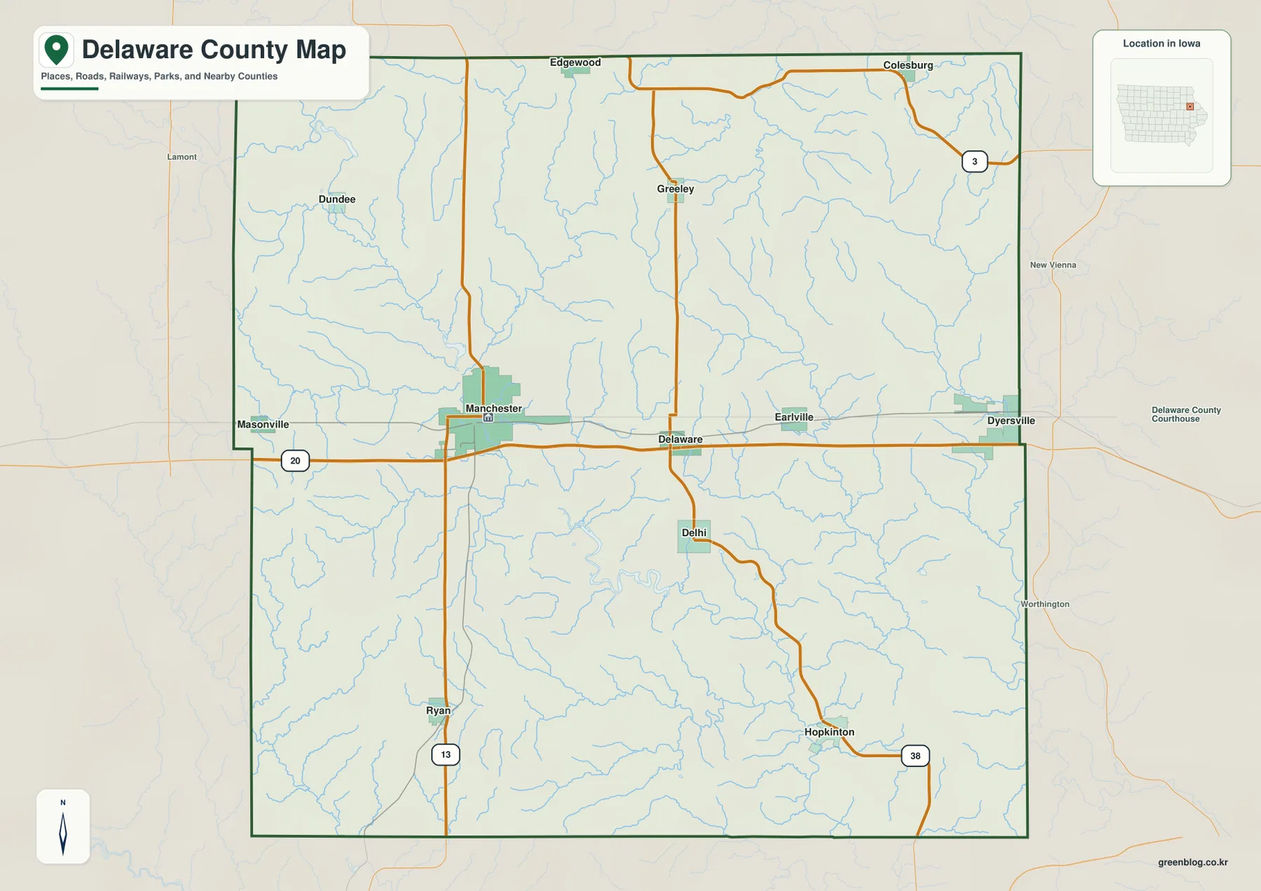
The neighboring county labels provide a broader frame. Clayton and Fayette counties are shown to the north, Dubuque County to the east, Jones County to the south, Linn County to the southwest, and Buchanan County to the west. Those names are useful for understanding where Delaware County sits within northeastern Iowa, but this page concentrates on features inside the county boundary. For travel beyond the county, use the overview as a regional reference and pair it with current road information.
A settlement pattern spread from Manchester to Colesburg and Hopkinton
The city-distribution map highlights Manchester, Earlville, Edgewood, Hopkinton, Colesburg, and Delhi. Its index shows Manchester at 5,191, followed by Earlville at 868, Edgewood at 752, Hopkinton at 670, Colesburg at 545, and Delhi at 432. Those are the values printed on the supplied map and are used here only as a guide to the relative scale of the six mapped communities. Manchester stands apart as the largest indexed place, while the other towns form a dispersed pattern rather than one continuous urban corridor.
The geographic arrangement is as important as the index values. Earlville lies east of Manchester near the U.S. 20 corridor. Edgewood and Colesburg occupy the northern side of the county, where the elevation map later shows extensive higher ground. Hopkinton is isolated farther southeast, and Delhi sits in the south-central portion of the county near the Maquoketa River system. This spread makes the city map especially helpful for learning the county in sections: Manchester for the west-central road network, the northern towns for the ridge country, and Delhi–Hopkinton for the lower river valleys.
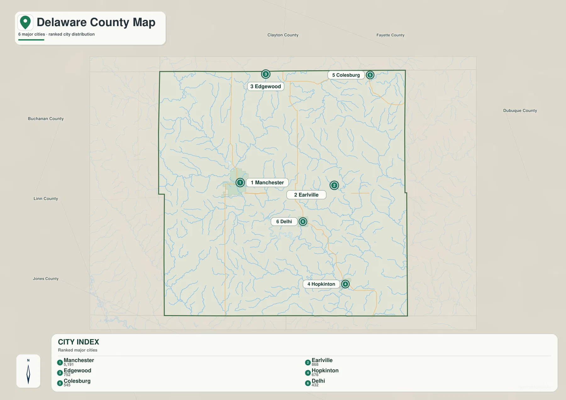
The road and terrain patterns reinforce this division. Manchester and Earlville are relatively easy to place from the east–west highway line. In the north, Edgewood and Colesburg sit among a denser web of short tributaries and higher ridges. Delhi and Hopkinton are closer to the lower Maquoketa River drainage and its branches. Remembering one road, one town, and one terrain feature for each part of the county is more useful than memorizing a long list of place names.
Maquoketa River drainage, Little Turkey River, and the named lakes
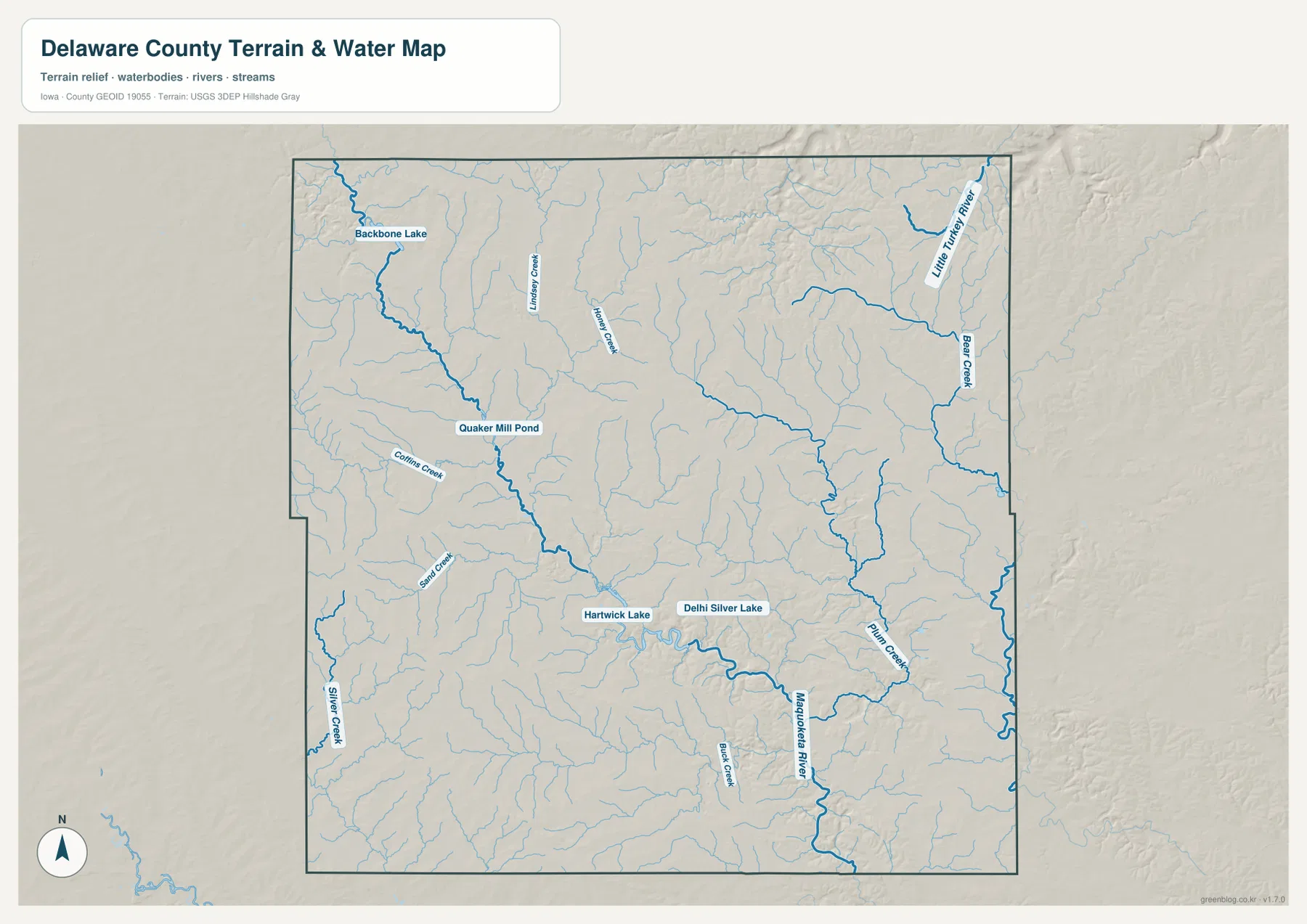
The terrain-and-water map reveals a much more intricate landscape than the road map alone suggests. The Maquoketa River is the strongest water feature in the central-southern part of the county and continues toward the southeast. Buck Creek and Plum Creek connect with the broader drainage pattern, while smaller streams cut the surrounding uplands. On the western side, Silver Creek, Sand Creek, and Coffin Creek appear as separate drainage lines. Backbone Lake and Quaker Mill Pond provide easy visual anchors in the northwest and west-central areas.
The northeastern corner belongs to a different set of named waterways. Little Turkey River is labeled near the northeast boundary, and Bear Creek runs through the eastern side. Lindsey Creek and Honey Creek appear farther west and north-central, where numerous small tributaries divide the uplands. This makes it useful to think of Delaware County as a county of several drainage corridors rather than a place dominated by one river from boundary to boundary.
Several water bodies help break the network into memorable sections. Backbone Lake lies in the northwest, and Quaker Mill Pond appears downstream in the western half. Hartwick Lake and Delhi Silver Lake sit close together in the south-central part of the map, near the Maquoketa River corridor. These features are valuable for orientation, but the map is not a flood forecast, depth chart, navigation product, or legal water-boundary record. Water safety, flood risk, access rules, and current conditions should be checked with the appropriate agencies.
Elevation from 234 to 368 meters across the ridges and valleys
The supplied elevation map reports an actual range of about 234 to 368 meters, with a mean of 308 meters. Higher brown and orange terrain covers much of the northern and northeastern part of the county, especially around the Edgewood–Greeley–Colesburg side. Lower green corridors become more common toward the central and southern river valleys. The most important feature is not simply that the north is higher; it is that streams carve narrow low paths into the uplands, producing a repeated ridge-and-valley texture.
The north is therefore not a single flat plateau. Tributaries create many short, branching valleys that interrupt the higher ground. Around the northeast, lower green lines correspond to the Little Turkey River and Bear Creek system. In the south-central portion, the Maquoketa River forms a broader low corridor, with additional low ground extending along connected creeks. The west-central drainage toward Quaker Mill Pond also cuts through terrain that otherwise rises toward the north.
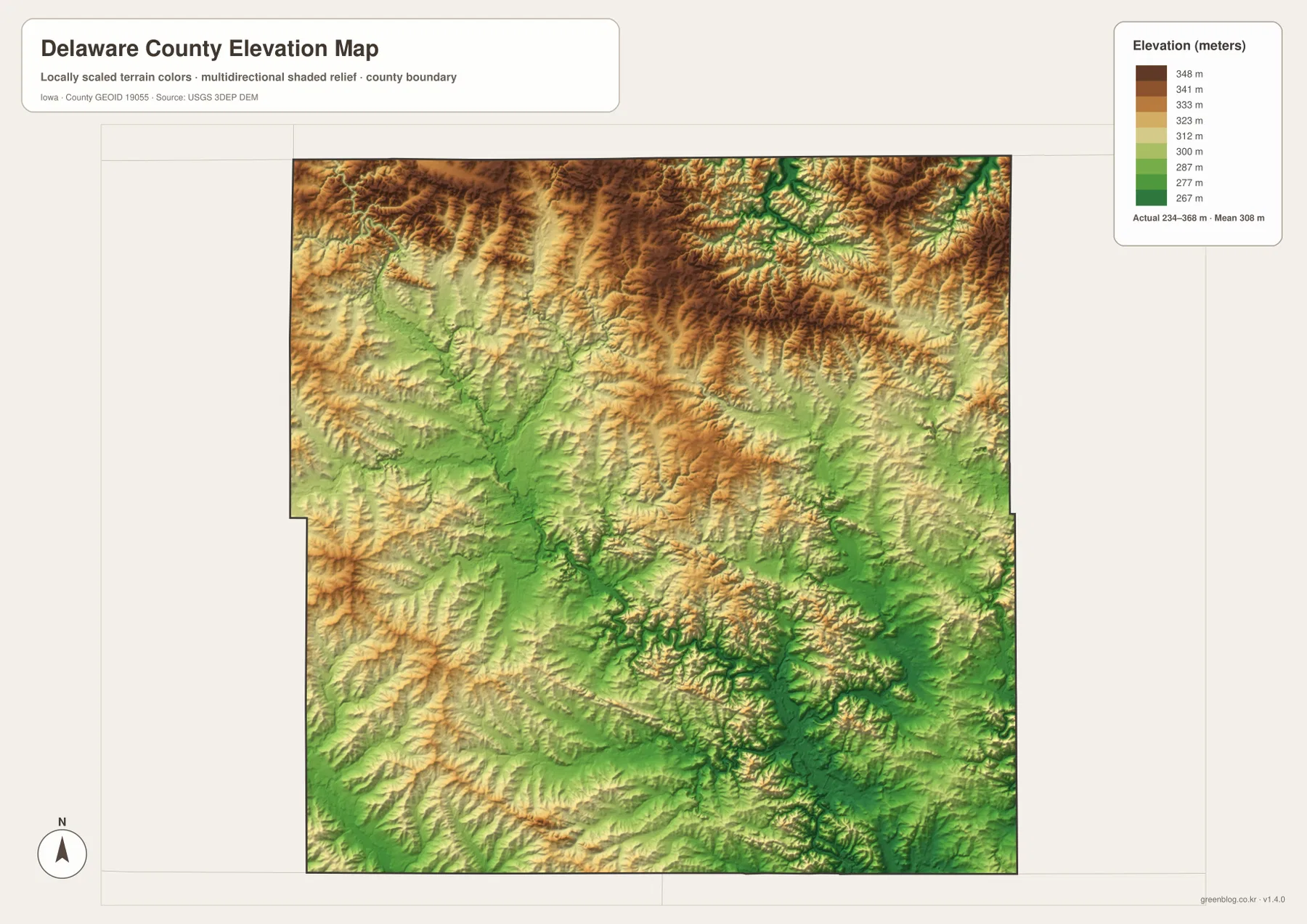
This generalized surface is intended for county-scale comparison, not exact surveying. Elevation can vary inside a single color band, and stream banks, road cuts, and individual properties may change over very short distances. Construction, drainage design, engineering, and property-specific work should rely on original elevation datasets or professional survey information. Here, the elevation map is most useful for explaining why the northern towns sit in more strongly dissected high ground while the Maquoketa River corridor appears lower.
Reading the Delhi area through lakes, river valleys, and relief
Delhi is a particularly useful anchor because several map layers come together nearby. On the county overview it lies south of Delaware, while the water map places Hartwick Lake and Delhi Silver Lake in the same general part of the county. The Maquoketa River system passes through this south-central landscape, and the elevation map shows a corresponding band of lower green terrain. Starting with Delhi, then locating the lakes, and finally comparing elevation makes the relationship between settlement, water, and valley relief easy to see.
Looking southeast from Delhi brings Plum Creek and the broader Maquoketa drainage toward the Hopkinton side of the county. Looking north leads back toward Delaware, Earlville, and progressively higher terrain. Westward, the Manchester side provides a different road-centered reference before the land rises again toward northern ridges. Using Delhi as a midpoint prevents the map from becoming a simple north-versus-south comparison and shows how the major river corridor links several parts of the county.
Contrasting the northern towns with the Hopkinton side of the county
Edgewood and Colesburg occupy the northern edge of the city map, and their surroundings are dominated by higher ridge colors on the elevation map. The area is still crossed by many small creeks, so the high ground is broken rather than smooth. Greeley adds another northern reference on the county overview. Together, these places represent the part of Delaware County where short tributary valleys repeatedly cut into relatively elevated terrain.
Hopkinton presents a different setting in the southeast. Iowa 38 is visible nearby on the road map, while the water map shows Plum Creek and the larger Maquoketa River system within the surrounding landscape. Lower green elevations are more extensive than in the northern ridge country. Comparing Edgewood–Colesburg with Hopkinton–Delhi makes the 234–368 meter range meaningful: the numbers correspond to a visible change from dissected northern uplands to lower southern river corridors.
Choosing the right Delaware County map for roads, towns, water, or relief
For general orientation, start with the county overview and locate Manchester, U.S. 20, Delaware, Earlville, Edgewood, Colesburg, and Hopkinton. That gives enough structure to understand the county before adding more detail. If the main question is how the six highlighted communities are distributed, the city map is cleaner because it removes most road detail and makes the spacing between Manchester, the northern towns, Delhi, and Hopkinton more obvious.
For rivers and lakes, begin with the Maquoketa River and Little Turkey River, then add Backbone Lake, Quaker Mill Pond, Hartwick Lake, and Delhi Silver Lake as fixed reference points. If terrain is the priority, identify the 234–368 meter range on the elevation map, find the higher northern ridges, and then follow the green low corridors back to the water map to name the associated rivers and creeks. Moving between the water and elevation maps is the easiest way to turn the branching relief into recognizable drainage features.
The WebP images in the article are optimized for quick viewing. The ZIP below contains separate high-resolution JPG versions of the county overview, major-city, terrain-and-water, and elevation maps for printing, classroom use, presentations, or personal reference. They are general geographic resources and do not replace legal boundary records, parcel data, live road conditions, flood information, or precise survey measurements.
Frequently Asked Questions
Which map is best for locating Manchester and following U.S. 20 across the county?
The county overview is the best starting point. It places Manchester on the west-central side and lets you follow U.S. 20 east toward Delaware and Earlville while also comparing Iowa 13 to the south and the northern towns of Edgewood, Greeley, and Colesburg. Use the major-city map next if you want a cleaner view of the six highlighted communities without most road detail.
What water features are most useful for learning Delaware County?
Start with the Maquoketa River in the central-southern part of the county and the Little Turkey River in the northeast. Backbone Lake, Quaker Mill Pond, Hartwick Lake, and Delhi Silver Lake are useful fixed points, while Bear Creek, Plum Creek, Buck Creek, Silver Creek, and other tributaries explain why the terrain is divided into so many small valleys.
How should the 234–368 meter elevation range be interpreted?
The map reports a mean elevation of 308 meters. Higher orange and brown terrain is widespread in the north and northeast, while lower green ground follows the Maquoketa River and many tributary valleys through the central and southern parts of the county. The map is appropriate for county-scale comparison, but property-level, engineering, or construction work requires original elevation data or professional surveying.
Map File Information
The ZIP contains high-resolution JPG versions of the Delaware County overview, major-city, terrain-and-water, and elevation maps.
- Included Files: Use only the versions confirmed in the article and supplied images
- File Type: Use the confirmed download contents
- Intended Use: Printing, education, presentations, and map-based projects
Related Maps
Sources and reference data
The official resources below provide more detailed boundary, hydrography, and elevation data for county-scale geographic reference. The maps on this page are simplified for general understanding, so the original datasets should be used whenever exact geometry or elevation values matter.
These maps are general-reference resources for orientation, learning, printing, and presentation use. Legal boundaries, property ownership, current road conditions, flood hazards, and precise elevations should always be checked against the responsible agency’s current records and appropriate professional data.
Green Map creates custom-edited map images using open geographic data sources such as geoBoundaries, Natural Earth, OpenStreetMap, and government open data.
These maps are edited visual materials, not raw data files, and are provided for education, documents, presentations, and graphic reference.