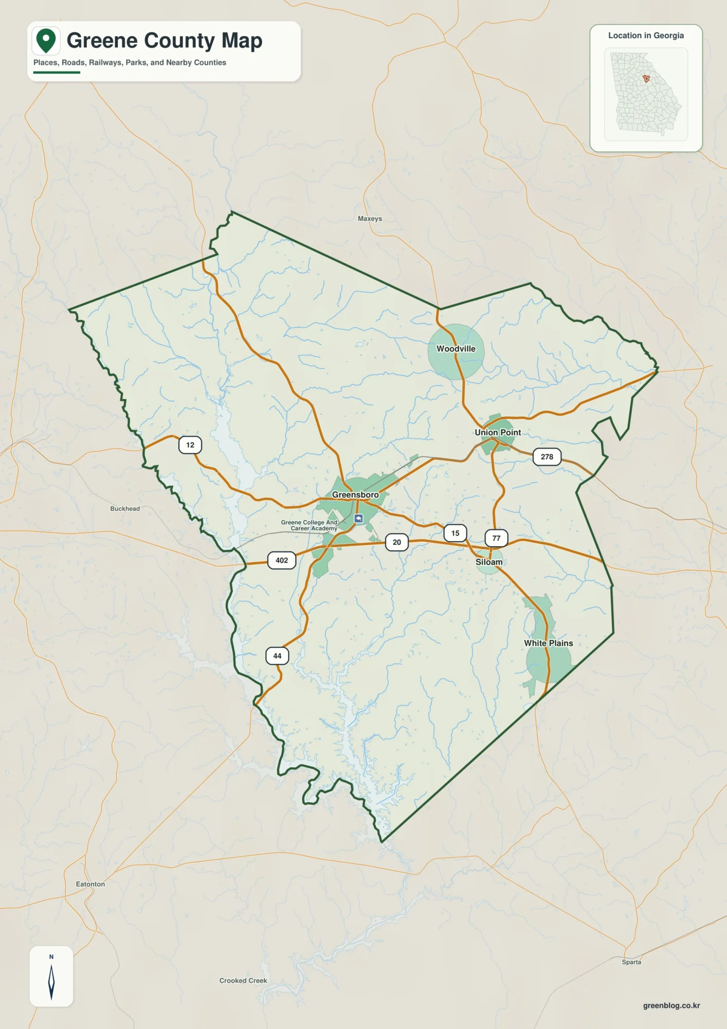
Fairfield is the easiest place to begin with Wayne County in southern Illinois, but the county extends well beyond that central reference point. Wayne City and Sims lie to the west, Cisne and Jeffersonville are north of Fairfield, and Mount Erie sits farther northeast. The maps on this page combine those settlement positions with principal roads, named lakes and streams, and terrain ranging from roughly 111 to 183 meters. Matching high-resolution JPG files are available in one ZIP package for printing or larger reference use.
Fairfield is the most useful starting point for orientation. It sits a little south of the county’s center and stands out as the largest built-up area on the general map. Wayne City and Sims are to the west, Cisne and Jeffersonville lie to the north, Mount Erie is in the northeast, and Mill Shoals sits close to the southern edge. The water map tells a different story, replacing road emphasis with Sam Dale Lake, Elm River, Little Wabash River, ponds, lakes, and many narrow tributaries. The elevation map then explains why those water lines follow particular corridors through the county.
The strongest contrast in Wayne County is between higher ground in the west and northwest and broader low areas across much of the center and east. The elevation surface also shows smaller ridges returning in the southeast, so the county is not simply high on one side and flat on the other. By moving from towns and roads to water and relief, the maps make it easier to see how Fairfield fits into a county where settlement is dispersed and natural drainage occupies much of the space between communities.
Table of Contents
Fairfield as the practical center for road orientation
Fairfield is the clearest reference point on the general county map. The Wayne County Courthouse is located in Fairfield, and the county government’s official website lists its main offices there. On the map, the city is surrounded by roads extending north, west, east, and south, making it easy to compare the positions of smaller communities. From Fairfield, Cisne and Jeffersonville are northward, Wayne City and Sims are westward, Golden Gate is to the east, and Mill Shoals is near the southern boundary.
Several major routes help establish direction. U.S. 45 runs north-south through the county, passing the Cisne area before continuing toward Fairfield. Illinois 15 crosses the southern half from the Wayne City side toward Fairfield and farther east. I-64 follows the southern edge near Mill Shoals. Other numbered roads appear on the supplied map as well, but the purpose of this page is regional orientation rather than turn-by-turn navigation. The map is best used to understand where towns and principal corridors sit inside the county boundary.
The named communities are widely separated rather than forming one continuous urban belt. Johnsonville appears in the northwest, Cisne is farther east in the northern half, and Mount Erie sits near the northeastern side. Jeffersonville lies between Cisne and Fairfield, while Sims and Wayne City occupy the western portion. Golden Gate is east of Fairfield and Mill Shoals is near the south. That spread is one reason a county-wide map is useful: a simple list of place names does not show how much rural land and stream network lie between them.
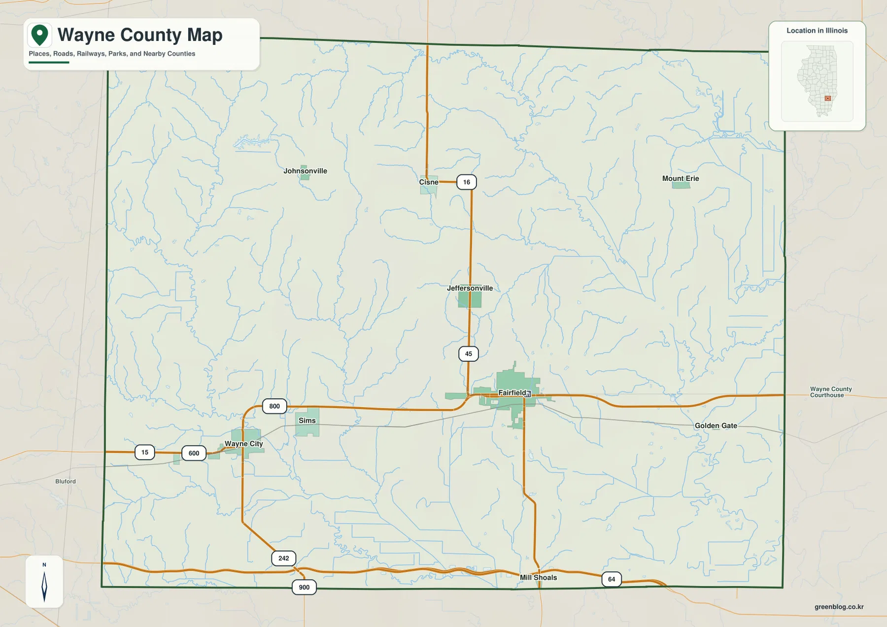
Neighboring-county labels add useful context around the edge. The city map places Clay and Richland Counties to the north, Edwards County to the east, White County to the southeast, Hamilton County to the southwest, Marion County to the west, and Jefferson County to the northwest. Those labels are especially helpful when looking at Mount Erie near the eastern side or Wayne City toward the west, because they show that different Wayne County communities sit much closer to different county lines.
A dispersed settlement pattern from Wayne City to Mount Erie
The city-distribution map reduces road detail and emphasizes six labeled communities: Fairfield, Wayne City, Cisne, Jeffersonville, Mount Erie, and Sims. Fairfield occupies the central-southern position, Wayne City and Sims sit to the west, Cisne and Jeffersonville are north of Fairfield, and Mount Erie is farther northeast. This arrangement makes the county’s settlement pattern easy to grasp. The selected communities do not form a compact cluster; they are separated by wide areas where waterways and rural roads become more visually prominent.
The index on the supplied map ranks Fairfield first, followed by Wayne City and Cisne, with Jeffersonville, Mount Erie, and Sims also included. Those values belong to the map’s own city index and should not be treated as a substitute for current official population estimates. Their main value here is cartographic: they explain why Fairfield is the primary reference point and why several smaller communities were selected to represent different parts of the county.
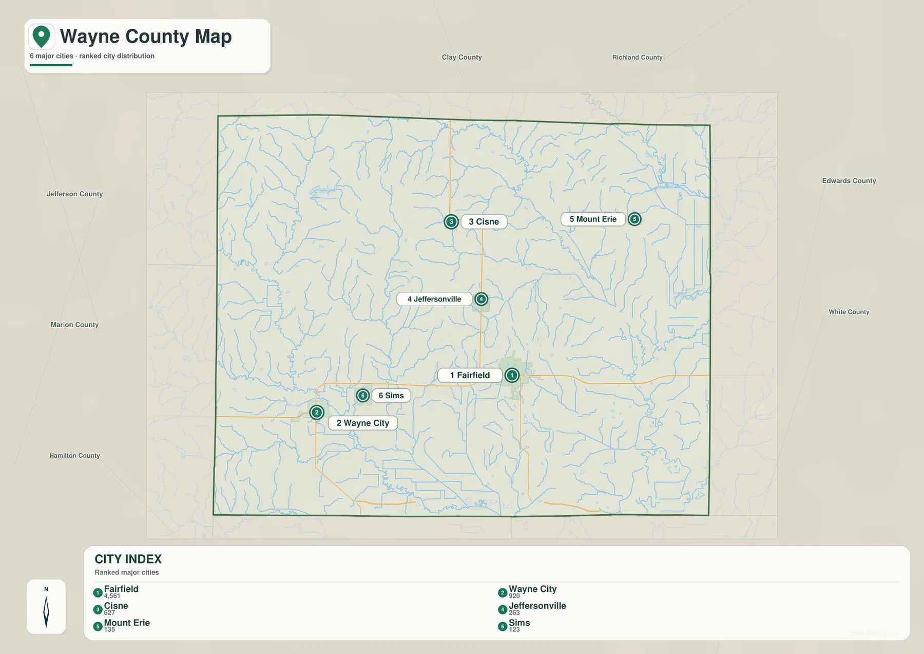
This map does not draw connector lines or give point-to-point distances, so it should be read as a location and ranking view rather than a mileage chart. For example, Wayne City is clearly west of Fairfield, Cisne is north, and Mount Erie is northeast, but the image does not claim a driving distance between those places. Use a current road map or navigation service for routing. For county-level explanation, however, the simplified view is valuable because it lets the reader compare direction and distribution without the clutter of every road and stream.
Comparing this simplified map with the general county map reveals how the roads relate to the settlement pattern. Wayne City and Sims lie close to an east-west corridor that continues toward Fairfield. Cisne and Jeffersonville align with the north-south U.S. 45 corridor. Mount Erie is more detached in the northeast, while Fairfield functions as a meeting point for several directions. That relationship between dispersed communities and a few stronger road corridors is a more useful description of Wayne County than treating the county as a single centered town surrounded by empty space.
Sam Dale Lake, Elm River, and the Little Wabash drainage
The terrain-and-water map shifts attention away from settlements and toward a dense network of streams. Sam Dale Lake is labeled in the northwest, where Illinois Department of Natural Resources describes the Sam Dale Lake State Fish and Wildlife Area as a Wayne County site of gently rolling terrain, woods, and a lake. Its position on the map is useful because it sits near the higher western side of the county, where narrow valleys cut through ridges before water moves toward lower ground.
Elm River is a prominent named watercourse in the northeastern part of the map. Farther east, Goose Pond and Old River Lake appear near the county edge. The southeast is dominated by the winding Little Wabash River corridor, while smaller lakes and water bodies such as Steiner Lake, Cox Lake, Briar Patch Lake, and Skillet Fork Lagoon are shown farther south. The many thin tributaries between these named features make the county look finely divided by drainage even where there are few large lakes.
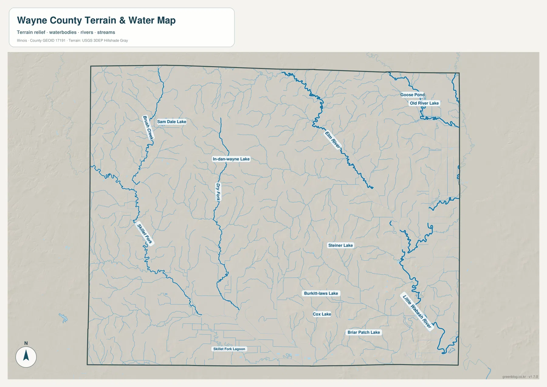
The map is most useful for following the position and general course of waterways. It is not a flood-hazard map, parcel map, legal boundary survey, depth chart, or navigation product. A thin blue tributary may be important for local drainage without being suitable for boating, and the presence of a labeled lake does not indicate public access. For those questions, consult the responsible state or local agency. Here, the value of the map is seeing how water features occupy the valleys between higher pieces of terrain.
The relationship becomes clearer when the water map is compared directly with elevation. Many stream corridors coincide with greener, lower terrain. In the west, tributaries cut narrow paths between the higher brown ridges. Across the center and east, the low areas become broader and the drainage network spreads through gentler relief. In the southeast, higher ridges return in patches while the Little Wabash River follows a lower route beside them. Reading the two maps together makes the county’s drainage far easier to understand than following blue lines alone.
From 111 to 183 meters: western ridges and broad eastern lows
The elevation map reports an actual county range of about 111 to 183 meters, with a mean near 133 meters. Lower ground is shown in green, while higher areas move through yellow and brown. The most continuous high terrain appears in the west and northwest. Long ridges and rolling uplands occupy much of that side of the county, interrupted by narrow green valleys. This pattern gives the western map a distinctly more textured appearance than the broad green areas farther east.
Central and eastern Wayne County are generally lower, but the transition is not perfectly smooth. Large green zones are crossed by shallow valleys and scattered higher patches. The southeast contains a noticeable group of ridges that rises above the surrounding lowland, while the Little Wabash River corridor remains lower. In the northeast, low green terrain dominates more widely, though small changes in relief still appear along tributaries and local rises. The county therefore has several terrain zones rather than one simple west-to-east slope.
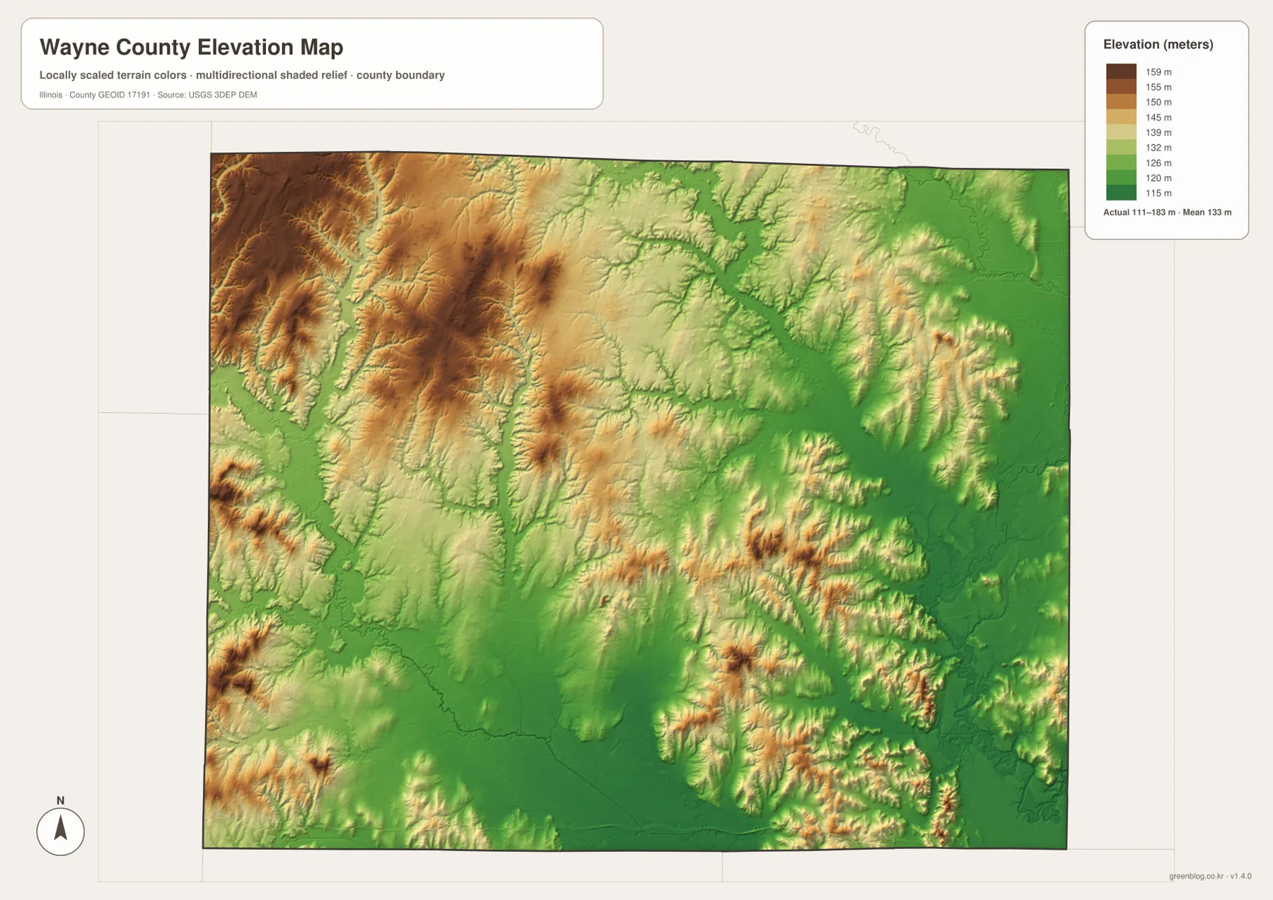
Settlement locations can be reconsidered against this terrain. Fairfield sits away from the strongest western ridge colors and closer to the broad lower central portion. Wayne City is west of Fairfield but still east of some of the highest western relief. Cisne and Mount Erie are associated with the lower northern and northeastern landscape, while the southern edge near I-64 crosses a mixture of low ground and local rises. This does not mean elevation alone determined where each community developed, but the map provides useful physical context around the road and town pattern.
The elevation surface is intended for county-scale comparison, not engineering or survey work. Do not use it as a precise elevation for a building site, drainage design, property boundary, or construction decision. Those tasks require authoritative detailed data or field measurements. For general map reading, the surface is very effective: it shows where the western ridges are concentrated, which corridors sit lower, and how waterways thread through the terrain.
Choosing the right Wayne County map for the task
Start with the general map when your main question is where a place or road is located. Fairfield provides the anchor, and U.S. 45, Illinois 15, and I-64 give the county a clear road framework. From there, it is easy to find Wayne City, Cisne, Mount Erie, Golden Gate, Mill Shoals, and the county edges. This is also the best map for explaining how a town sits relative to neighboring counties because it keeps settlements, roads, water lines, and the boundary in one view.
Use the city-distribution map when the settlement pattern itself is more important than detailed roads. It is especially useful for a classroom handout, presentation, or quick regional overview because six selected communities stand out immediately. The map is not a population-density surface or a distance calculator, so its strength is clarity rather than measurement. It answers the simple geographic question of where the main labeled communities sit across the county.
For natural geography, the terrain-and-water map and elevation map are strongest when used together. Find Sam Dale Lake, Elm River, and Little Wabash River first, then compare those features with the green lowlands and brown uplands on the elevation surface. The water map supplies names and courses; the elevation map supplies the shape of the land around them. If the goal is to discuss western hills, use the elevation map. If the goal is to identify lakes or river corridors, use the water map.
The WebP images in the article are optimized for on-page viewing. The ZIP below contains the original high-resolution JPG versions for printing, larger screens, and projects that need more detail. Since each map gives priority to different information, choose the file that matches your question rather than relying on a single image for everything. Combining the general map with the elevation map works well for settlement-and-terrain context, while pairing the water and elevation maps is better for explaining drainage and valleys.
Frequently Asked Questions
Which map is best for locating Fairfield, Wayne City, Cisne, and Mount Erie?
Use the general county map when you also want roads and boundary context. Use the city-distribution map when you only need a cleaner comparison of the major labeled communities. Fairfield is the central reference point, Wayne City lies west, Cisne is north, and Mount Erie is northeast. For an actual drive between them, check a current road or navigation map because the city-distribution image does not provide driving distances.
How can I compare Sam Dale Lake with the Little Wabash River corridor?
Begin with the terrain-and-water map. Sam Dale Lake is in the northwestern part of Wayne County, while the Little Wabash River is prominent along the southeast. Then compare both areas on the elevation map. The Sam Dale Lake side is close to higher western relief, while much of the Little Wabash corridor follows lower green terrain beside scattered southeastern ridges.
Can the 111–183 m elevation map be used for surveying or construction?
No. The map is designed to show county-scale relief and relative height differences. It is useful for recognizing the higher west and northwest, the broad central-eastern lowlands, and smaller southeastern ridges, but it is not survey-grade or engineering-grade measurement. Site design, drainage, construction, and property work require authoritative detailed data or field measurements.
Map File Information
The ZIP package contains the high-resolution JPG versions of the Wayne County general map, city-distribution map, terrain-and-water map, and elevation map. Review the web images above, then download the original-size files when you need printable or larger reference copies.
- Included Files: 4 high-resolution JPG maps
- Printable Size: 2572 × 3638 px each
Related Maps
Sources and References
The following official resources provide county information and background for the boundary, hydrography, elevation, and Sam Dale Lake references used with these maps.
- Wayne County, Illinois official website — county government and Fairfield courthouse information
- Illinois Department of Natural Resources – Sam Dale Lake — official information for the Wayne County lake and wildlife area
- U.S. Census Bureau TIGER/Line Shapefiles — county boundary and geographic framework
- USGS National Hydrography — stream and water-feature data
- USGS 3D Elevation Program — elevation and terrain data
Green Map creates custom-edited map images using open geographic data sources such as geoBoundaries, Natural Earth, OpenStreetMap, and government open data.
These maps are edited visual materials, not raw data files, and are provided for education, documents, presentations, and graphic reference.