Download the high-resolution A3 JPG Stark County Illinois Map ZIP directly from this page. Stark County is a compact but topographically varied county centered on Wyoming and Toulon, with Bradford in the northeast and La Fayette near the western edge. The road map looks relatively simple at first, but the water and elevation views reveal a deep central network of Spoon River valleys separating higher ground along the east and west sides of the county.
The WebP maps in the article are optimized for quick browser viewing, while the matching original JPG files make small road and creek labels easier to enlarge or print. A useful orientation sequence is to find Wyoming and Toulon first, then Bradford to the northeast and La Fayette to the west. After those communities are familiar, follow Spoon River through the middle of the county and add the East Fork, West Fork, Indian Creek, and Walnut Creek to understand how the local relief is organized.
Table of Contents
Wyoming, Toulon, and the county’s stepped boundary
Wyoming and Toulon are the two easiest communities to use as central references on the general county map. Wyoming lies slightly east of the center, while Toulon sits to the west. Numbered roads 700 and 770 extend east from the Wyoming area, with 400 and 91 continuing south. Around Toulon, road 17 provides a clear westward connection toward La Fayette. The road pattern is sparse enough that these few labels quickly establish the county’s main orientation.
Bradford is the strongest northeastern landmark. It sits near the meeting of 93 and 40, with 93 stretching west across the northern part of the county. In the southwest, 78 and 300 provide additional reference lines. The exact route classification matters less than the pattern printed on the supplied map: Wyoming, Toulon, Bradford, and La Fayette occupy four clearly separated parts of the county, so the numbered roads are easiest to read in relation to those communities.
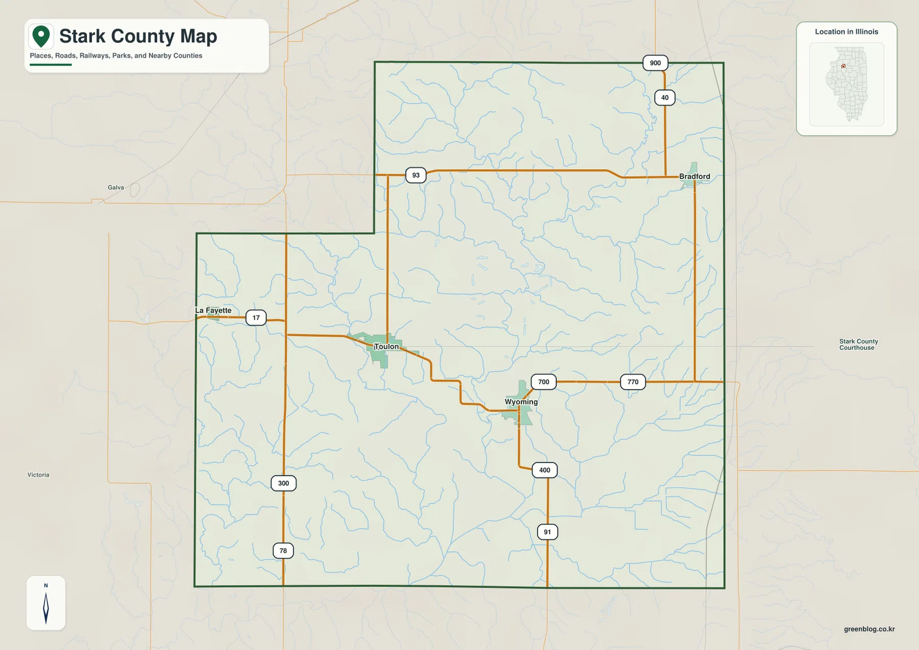
The county boundary itself is distinctive. The northwestern side steps inward before the northern section expands again to the east, creating a shape that is wider in different places depending on latitude. Bradford occupies the broader northeastern block, while La Fayette is close to the western projection of the southern half. This stepped outline makes the full county map particularly useful because a simple rectangular mental model would place the towns incorrectly.
The official Stark County website notes that the county was formed in 1839 from Knox and Putnam counties. That history is useful background, but the geographic descriptions here remain tied to what is visible on the supplied maps: current county boundaries, labeled communities, numbered roads, waterways, and elevation differences.
Straight-line connections from Wyoming to three nearby communities
The city-connections map uses Wyoming as the hub and simplifies the county to four named communities. The printed values are Wyoming 1,578, Toulon 1,485, Bradford 772, and La Fayette 178. Those figures are described here only as values printed on the supplied city index; they are not presented as newly verified current population counts. The distance labels are also important: they are direct straight-line distances, not driving distances.
From Wyoming, Toulon is shown at about 5 miles, Bradford at about 10 miles, and La Fayette at about 11 miles in straight-line distance. Toulon lies northwest of Wyoming, Bradford northeast, and La Fayette much farther west. The three connections spread in different directions rather than following one single corridor, which is a useful summary of how Stark County’s principal settlements are arranged.
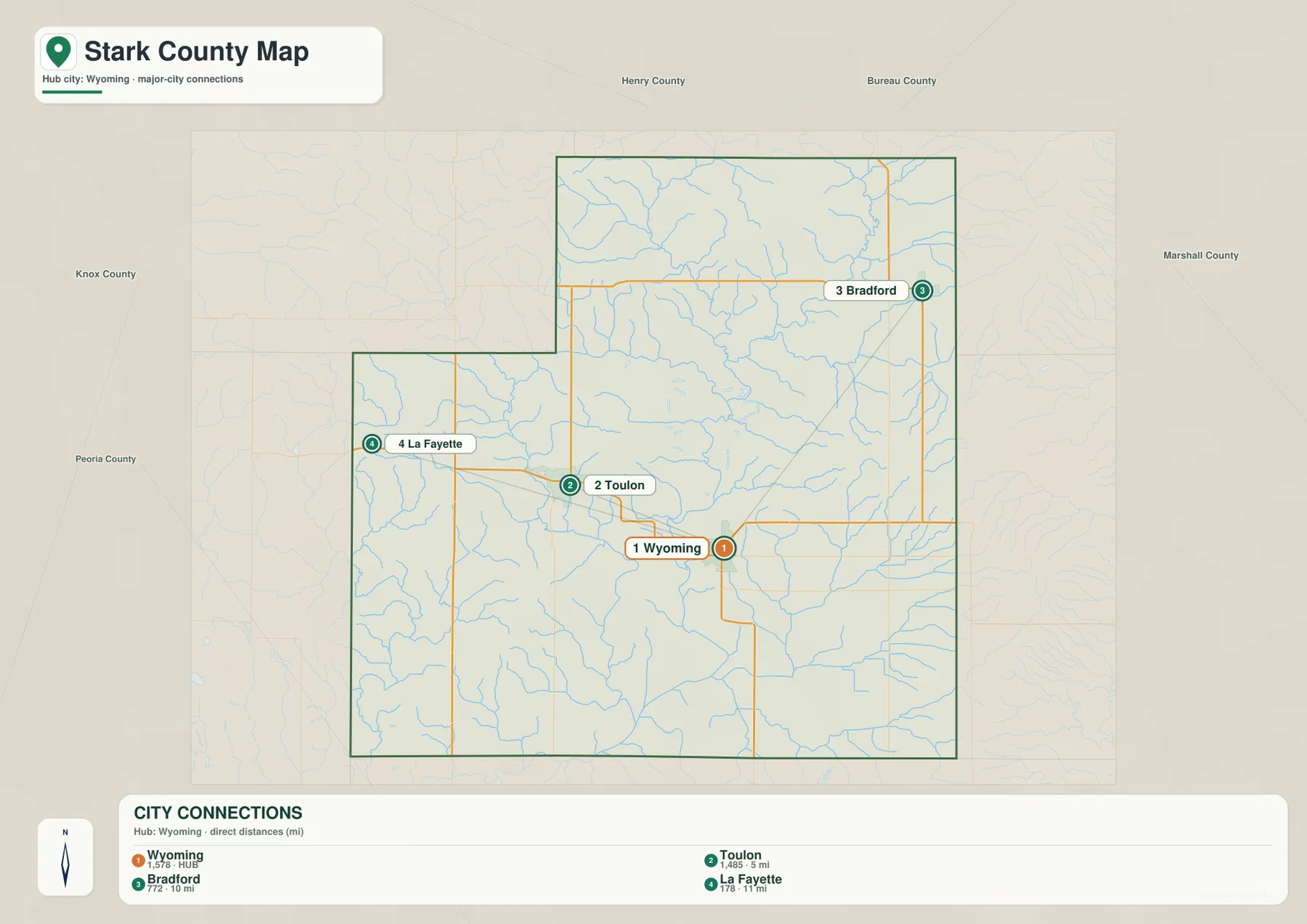
This is not a navigation map. A straight-line distance does not account for road curvature, intersections, bridges, or speed limits, so actual driving distance can be longer. Its value is in comparison: the map quickly shows which major community is closest to Wyoming and how the other two are positioned around the county. The general road map should be used when the route itself matters.
Spoon River and its east and west forks shape the central drainage
Spoon River is the dominant feature on the terrain-and-water map. It runs through the central county and continues south beyond the boundary. In the north, West Fork approaches from the northwest and East Fork Spoon River arrives from the northeast near the Fox Creek side of the map. Finding those three channels first makes the dense network of smaller tributaries much easier to understand.
Indian Creek enters the central river system from the west, with Jack Creek and Jug Run labeled farther north. Walnut Creek is one of the clearest streams in the southwest, and Fitch Creek appears toward the northwest. The road map shows many of these channels only as fine blue lines, but the terrain-and-water view makes their valleys much more visible and shows how they divide the higher ground into smaller ridges.
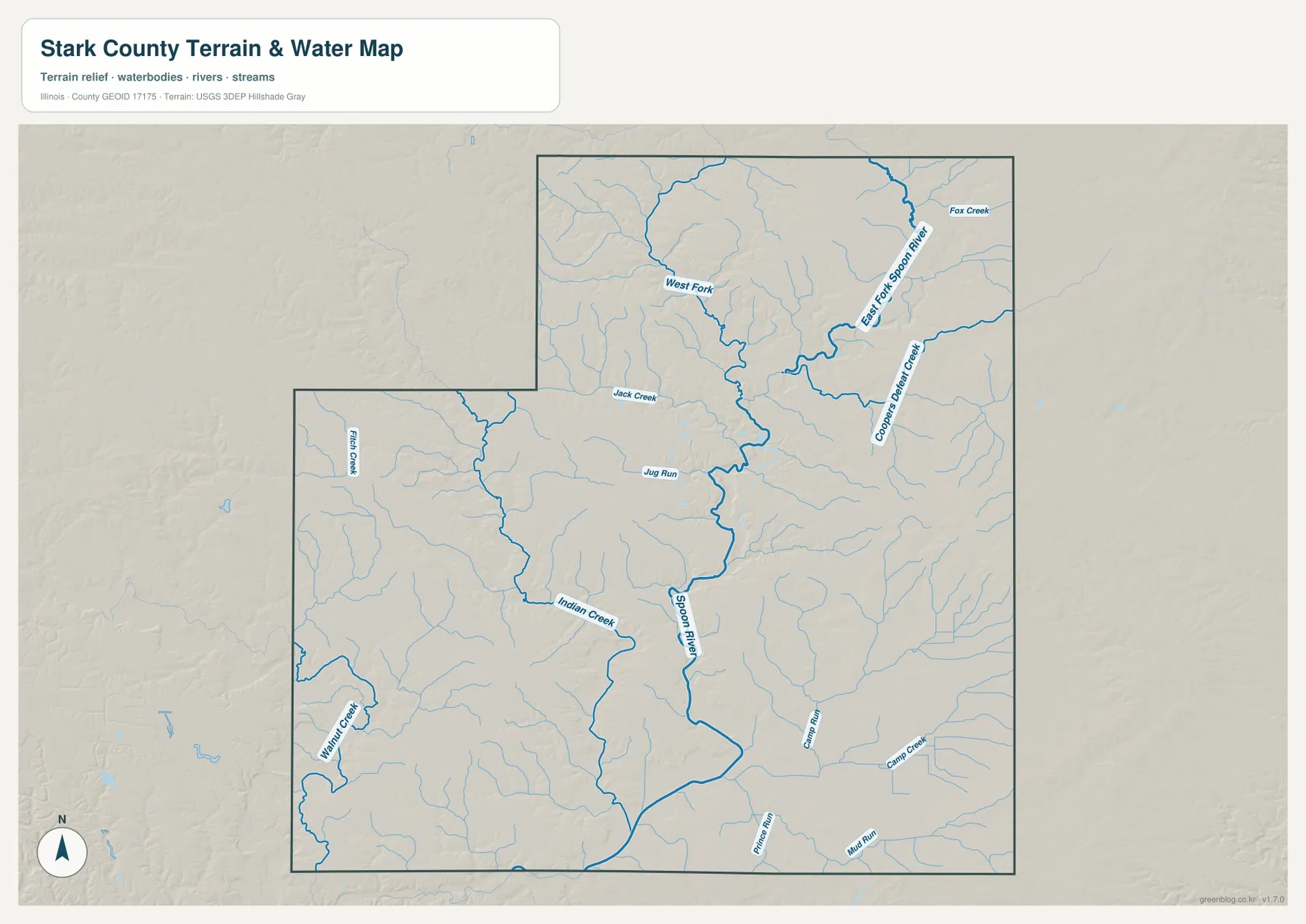
Fox Creek is labeled in the northeast near the East Fork, while smaller streams also cross the eastern interior. Camp Creek and Mud Run appear in the southern portion of the map. The important point is not to memorize every name at once but to see the hierarchy: Spoon River forms the main central valley, its two large forks organize the northern half, and smaller creeks enter from both the east and west.
This layer is intended for general geographic reference rather than flood-hazard, water-quality, navigation, parcel, or legal-boundary decisions. A mapped stream shows relative location, not public access, navigability, or current flood conditions. More specific water or legal questions require the appropriate current official source.
An 184 to 266 meter range separates river valleys from higher ridges
The supplied elevation layer reports an actual range of about 184 to 266 meters and a mean near 220 meters. The lowest green terrain follows Spoon River and its major tributary valleys through the center and toward the south. Warmer tan and brown colors spread across the western edge and across much of the eastern and northeastern sides. The total relief is moderate, but the repeated shift between creek valleys and adjacent ridges creates a strongly dissected appearance.
In the northern half, the East Fork and West Fork cut long low corridors into higher terrain before joining the central river system. Farther south, Indian Creek, Walnut Creek, and smaller tributaries create the same pattern on a finer scale. Comparing the water map with the elevation map shows why many green bands follow the same branching lines as the streams: the watercourses occupy the lower parts of the landscape.
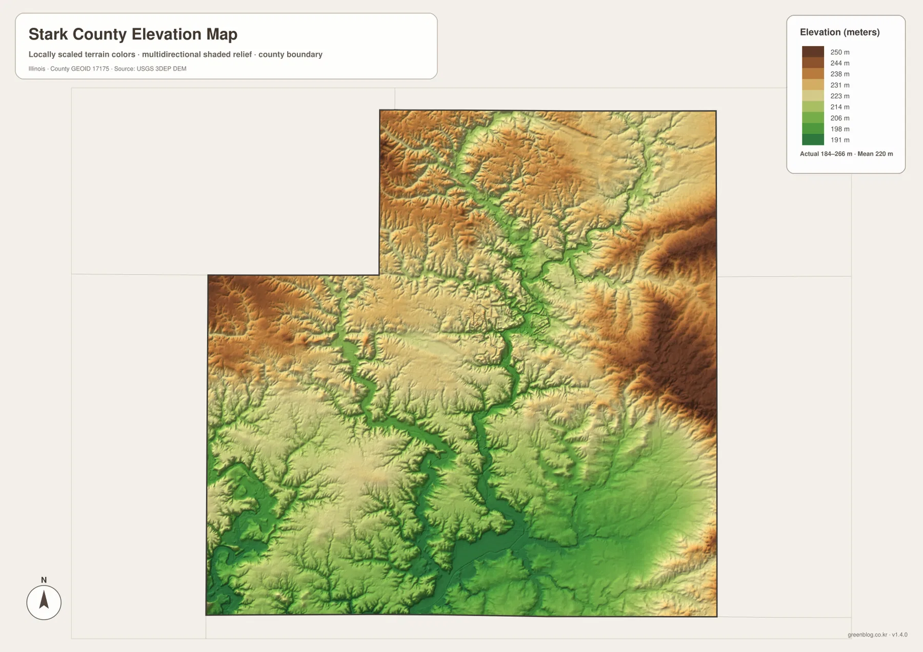
Relating the terrain back to the towns makes the map more intuitive. Wyoming and Toulon sit among gently higher surfaces broken by nearby creek valleys rather than on one perfectly flat plain. The Bradford side of the northeast is surrounded by more prominent high terrain, while the La Fayette side also alternates between uplands and narrow low drainage corridors. These differences are subtle on the road map but become obvious on the elevation view.
The elevation surface is intended for county-scale comparison, not parcel surveying or engineering design. The 184–266 m range is useful for identifying the Spoon River valley and the surrounding ridges, but it does not provide survey-grade elevation for a specific property. Construction, drainage, flood, and legal decisions require more precise and current data.
Which Stark County map should you use first?
For towns and numbered roads, begin with Wyoming and Toulon, then add Bradford in the northeast and La Fayette to the west. Use the city-connections map when the main question is how far the three other communities lie from Wyoming; remember that those values are straight-line distances. For water, start with Spoon River and the East and West forks, then add Indian Creek and Walnut Creek. The elevation view is most useful after those waterways are familiar because it shows which valleys are low and where the higher ridges sit around them.
The ZIP below contains four high-resolution JPG files matching the county-and-road map, city-connections map, terrain-and-water map, and elevation map on this page. Each image is 3638 × 2572 pixels in landscape orientation, making small road and stream labels easier to enlarge or print than in the browser-sized WebP versions. These maps are general reference products, so current traffic, legal parcel boundaries, flood determinations, water rules, and survey-grade elevations should be checked against the appropriate official source.
Frequently Asked Questions
What distances are shown from Wyoming to Toulon, Bradford, and La Fayette?
The city-connections map shows straight-line distances, not driving distances. Toulon is about 5 miles from Wyoming, Bradford about 10 miles, and La Fayette about 11 miles. Road travel can be longer because the actual routes do not follow perfect straight lines.
Which map best shows Spoon River and its tributaries?
The terrain-and-water map is the clearest choice. It shows Spoon River, East Fork Spoon River, West Fork, Indian Creek, Walnut Creek, Fox Creek, and several smaller waterways in the same county view. It is a general geographic reference rather than a flood, navigation, or legal-water-boundary map.
Where are the higher and lower areas in Stark County?
The supplied elevation layer shows the Spoon River and tributary valleys as lower green corridors, while higher terrain spreads along the western edge and across much of the east and northeast. The actual range is about 184 to 266 meters with a mean near 220 meters.
Map File Information
The ZIP contains high-resolution A3 JPG versions of the Stark County road-and-boundary map, city-connections map, terrain-and-water map, and elevation map.
- Printable Size: 3638 × 2572 pixels each
- File Type: ZIP containing 4 JPG files
Related Maps
Sources and references
- Official Stark County website – county overview, history, and government information
- Stark County Clerk & Recorder – county records and administrative information
- U.S. Census Bureau TIGER/Line Shapefiles – county boundaries, roads, and place references
- USGS National Hydrography – rivers and streams
- USGS 3D Elevation Program – elevation and terrain reference
Green Map creates custom-edited map images using open geographic data sources such as geoBoundaries, Natural Earth, OpenStreetMap, and government open data.
These maps are edited visual materials, not raw data files, and are provided for education, documents, presentations, and graphic reference.