Pike County, Illinois, has a map pattern that changes noticeably from west to east. Along the western edge, the Mississippi River is bordered by broad, low terrain with lakes, channels, and backwater features. Farther inland, the ground rises into a deeply cut landscape of ridges and creek valleys around communities such as Barry, Pittsfield, and Griggsville. Pittsfield is the largest place in the ranked community map, while Hull sits much closer to the river lowlands and Pleasant Hill and Nebo anchor the southern part of the county. The maps on this page are designed to make those relationships easy to follow, and the same map set is available as high-resolution JPG files in the download box below.
Rather than treating the county as a simple outline, it helps to compare four different views. The general county map shows roads, places, waterways, and the unusual county shape. The ranked community map isolates six major settlements so their positions are easier to compare. The terrain-and-water map brings the Mississippi River, Hadley Creek, the forks of Mc Kee Creek, Lake Pittsfield, Blue Creek, Bay Creek, Sixmile Creek, and several river-bottom lakes into focus. The elevation map then explains why the river edge looks so different from the interior: the mapped terrain ranges from about 87 to 269 meters, with an average near 183 meters.
Table of Contents
Roads and boundaries from the river edge to Pittsfield
Pittsfield is a practical starting point on the general map because it sits in the eastern half of the county and connects visually with several different parts of Pike County. Routes marked 54 and 106 pass near Pittsfield, while 72 and 107 are visible to the north around the Griggsville corridor. Route 104 appears across the northern extension, 96 runs near Pleasant Hill in the south, and 100 is shown close to the eastern edge. In the western section, Hull and Kinderhook are near routes marked 36, 57, and 110. These labels make more sense when read together with the place names rather than as a list of highway numbers.
The settlement pattern spreads across a county outline that is far from rectangular. The western boundary follows the Mississippi River in a long diagonal, and the county expands into a broad northern section before narrowing again toward the west. Pittsfield and Griggsville occupy the eastern interior, Barry lies farther west, and Hull is tucked into the western projection close to the river. Pleasant Hill and Nebo are well south of Pittsfield, while Milton and Pearl appear near the eastern and southeastern side. New Canton and El Dara provide useful reference points between the interior hills and the western lowlands.
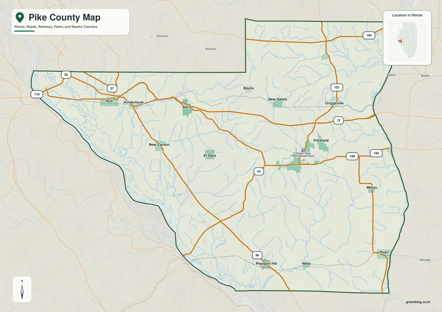
The map also shows many thin blue streams crossing the road network. That matters because a road that looks like a direct line across the county often passes through a series of creek valleys and rolling uplands. The western road pattern approaches the flat Mississippi margin, while the central and northern routes cross more dissected ground. This distinction is not obvious from road labels alone, but it becomes clear once the water and elevation maps are compared with the same towns.
This county map is intended for regional orientation, not for legal or engineering use. The boundary helps show where the county ends, but it is not a parcel survey. Road lines identify important travel corridors, but they do not report live traffic, temporary closures, or construction. Its strongest use is to answer straightforward questions: Where is Pittsfield relative to the river? Which direction is Barry from Griggsville? How far south are Pleasant Hill and Nebo compared with the northern communities? Once those relationships are clear, the specialized maps add the natural features that explain the landscape between the towns.
Six ranked communities spread from Hull to Pittsfield and the southern hills
The community map highlights six places and ranks them with values printed in the map index. Pittsfield is first at 4,420, followed by Barry at 2,152 and Griggsville at 1,310. Pleasant Hill is shown at 970, Hull at 413, and Nebo at 266. Those are the values printed on the supplied map and are best treated as the map’s ranking data rather than as a claim about the latest population estimate. What matters most for orientation is the separation between the six markers: the county does not have one continuous built-up strip joining all of its major communities.
Pittsfield occupies the eastern interior, Griggsville is north of it, and Barry sits farther northwest. Hull is the westernmost of the six and lies close to the Mississippi side of the county. Pleasant Hill and Nebo are both in the south, with Pleasant Hill farther west and Nebo closer to the central-southern interior. That arrangement leaves long stretches of rural land, creek valleys, and rolling terrain between the major places. The city map simplifies the road details, making those gaps easier to see than on the general map.
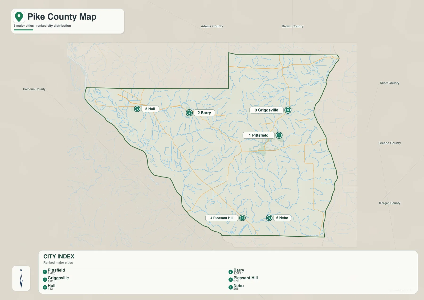
The six-place view becomes more useful when the terrain is added mentally. Hull is close to the very low Mississippi River plain, whereas Barry sits inland where the ground begins to rise and break into hills. Pittsfield lies in the interior rather than on the river edge, and the terrain around it is cut by several creeks. Griggsville is positioned near the southern side of the county’s broad northern extension. Pleasant Hill and Nebo sit among the southern ridges and valleys, where the elevation map shows much more relief than the western floodplain.
Several additional place names on the general map help fill the spaces between the ranked communities. Kinderhook lies between Hull and Barry, New Canton and El Dara appear farther south and west, and Baylis and New Salem provide northern interior reference points. Milton and Pearl mark the eastern to southeastern side. These smaller labels are useful when a reader needs more than the six highlighted settlements, especially when following a road or creek across a large part of the county.
Mississippi River backwaters and the inland creek network
The terrain-and-water map makes the western edge of Pike County look completely different from the interior. The Mississippi River forms the dominant water feature, accompanied in the southern river bottoms by Spring Lake, Towhead Lake, and The Sny. Murphy Bay is labeled farther north along the river corridor. Numerous narrow channels and water features fill the low ground next to the main river. This broad waterside zone contrasts sharply with the inland pattern, where streams are narrower and lie in valleys cut into rolling or hilly terrain.
Hadley Creek crosses the west-central interior, while Middle Fork Mc Kee Creek and South Fork Mc Kee Creek branch across the northern and northeastern part of the county. Lake Pittsfield appears east of the central settlement area, with Blue Creek running nearby. Farther south, Bay Creek is one of the more prominent mapped streams, and Sixmile Creek heads toward the Mississippi lowlands from the southwestern interior. Together, these waterways create a dense network of valleys rather than a single drainage line dominating the entire county.
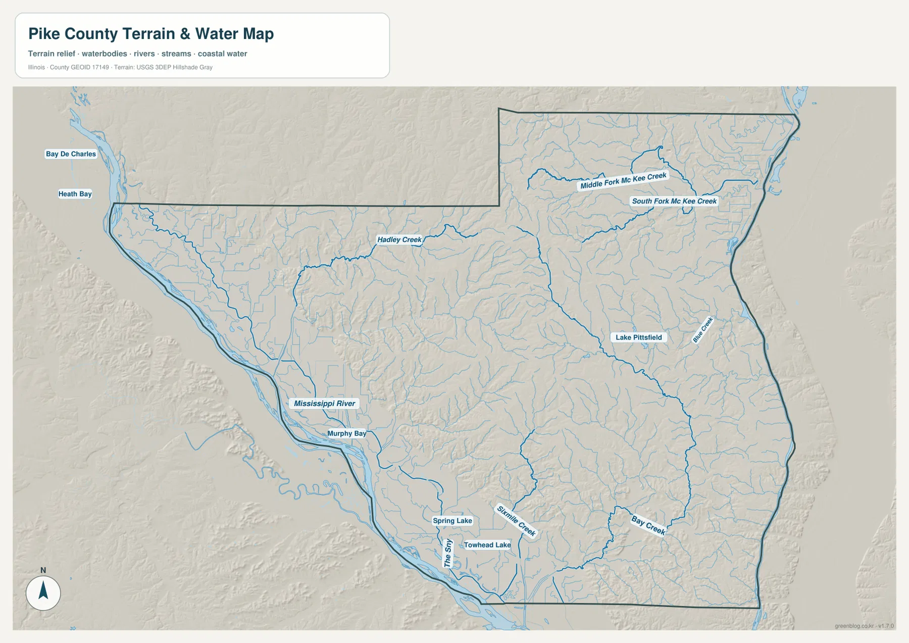
Comparing this map with the community map is especially useful around Pittsfield. Pittsfield itself is inland from the Mississippi River, while Lake Pittsfield and Blue Creek give the eastern side of the central area clear water references. Barry and Hull are associated with the western half, where Hadley Creek and the river corridor become more important. In the south, Pleasant Hill and Nebo are separated from the Mississippi margin by a landscape crossed by Bay Creek, Sixmile Creek, and many smaller tributaries.
The water map should be read as a geographic reference, not as a flood map or a navigation chart. A place being low or close to a river does not by itself define flood risk, and the blue lines do not establish property boundaries or legal water limits. The map is best used to locate named rivers, creeks, lakes, and channels and then compare their positions with roads, communities, and terrain. For that purpose, the Mississippi River and its broad lowland provide the strongest western reference, while the creek valleys explain much of the complicated interior relief.
An 87–269 meter landscape from Mississippi bottomlands to interior ridges
The elevation map gives Pike County an immediately recognizable west-to-interior contrast. The map reports an actual elevation range of about 87 to 269 meters and a mean near 183 meters. The western Mississippi River corridor is dark green, showing the county’s lowest broad terrain. Just east of that lowland, the surface rises quickly into yellow, tan, and brown hills. Across the central and northern interior, higher ridges are repeatedly cut by green valleys, producing a much more rugged appearance than the flat river margin.
The highest-looking terrain is not a single continuous mountain ridge. Instead, several elevated areas are separated by drainage valleys that branch in many directions. That pattern matches the water map: Hadley Creek, the Mc Kee Creek forks, Blue Creek, Bay Creek, and smaller tributaries occupy lower corridors between the uplands. The southern half continues the same theme with rolling and dissected ground, although the western edge drops again toward the Mississippi River plain.
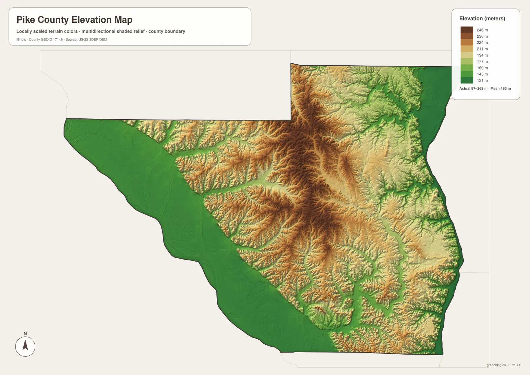
The community locations take on more meaning in this view. Hull is very close to the broad low western terrain. Barry is farther inland near the transition into more broken hills. Pittsfield lies among the interior ridges and creek valleys rather than on the flat river edge. Griggsville is also surrounded by a landscape where uplands are repeatedly cut by drainage lines. Pleasant Hill and Nebo are in the southern section, where the ground remains rolling and dissected but slopes toward lower areas near the western river corridor.
This elevation surface is meant for county-scale comparison. It is useful for seeing where the lowlands, uplands, ridges, and valleys are, but it is not survey-grade elevation data for a building site, road design, levee calculation, or engineering project. The colors generalize the landscape so regional differences are easy to see. For precise elevations, the underlying USGS data or a purpose-built survey is the appropriate source. Within the scope of this page, the elevation map is most valuable because it explains the shape of the water network and the striking difference between the Mississippi bottomlands and Pike County’s hilly interior.
Choosing the most useful Pike County map for the question
The general map is the best first choice when roads and named places matter. Start with Pittsfield and trace outward to Griggsville, Barry, Hull, Pleasant Hill, and Nebo; then use smaller places such as Kinderhook, New Canton, El Dara, Milton, and Pearl to refine the location. The community map is better when the goal is to compare the six ranked settlements without the distraction of many road labels. It quickly shows that Pittsfield is the largest mapped place and that the major communities are widely separated across the county.
For natural geography, the water and elevation maps work especially well as a pair. The water map identifies the Mississippi River, the lakes and channels of the western lowland, and the named creeks that enter the interior. The elevation map then shows whether those same places sit in broad low ground or in narrow valleys between higher ridges. Looking at Hadley Creek or Bay Creek in both views, for example, makes it easier to understand why the blue stream lines follow green corridors through brown and tan uplands.
The same approach works for community comparisons. Around Hull, the river lowland is the dominant physical feature. Around Barry, the transition to the interior hills is more noticeable. Pittsfield is best understood as an inland center surrounded by a dense creek-and-ridge landscape, while Griggsville sits farther north near the county’s expanded northern section. Pleasant Hill and Nebo provide southern reference points. Using the maps together keeps those differences tied to real named places instead of turning the page into a generic description of roads, rivers, and elevation.
The body maps are optimized for viewing on the page. When a larger image is needed for printing, close inspection, a classroom handout, or a personal reference file, the download archive contains the matching high-resolution JPG versions. These files are useful for general geographic study, but they do not replace current transportation notices, legal parcel records, flood insurance maps, or engineering surveys. The strongest use is straightforward: understand where Pike County’s communities are, see how the Mississippi River and creek system shape the county, and compare the broad western lowlands with the much higher interior terrain.
Frequently Asked Questions
What is the easiest place to use as an orientation point in Pike County?
Pittsfield is the simplest starting point on these maps. It is ranked first on the supplied community map and is easy to find in the eastern interior on the general map. From Pittsfield, Griggsville is to the north, Barry and Hull are farther northwest and west, and Pleasant Hill and Nebo are to the south. Once those directions are familiar, the Mississippi River on the west and Lake Pittsfield and Blue Creek on the east provide natural reference points.
What is the clearest terrain contrast on the Pike County maps?
The strongest contrast is between the broad Mississippi River bottomlands on the west and the higher, heavily dissected interior. The elevation map shows the western edge in low green colors, while tan and brown ridges rise inland and are cut by narrow green creek valleys. The water map reinforces the same pattern: wide river-bottom water features such as Spring Lake, Towhead Lake, and The Sny differ from the narrow inland valleys of Hadley Creek, the Mc Kee Creek forks, Bay Creek, and Sixmile Creek.
What files are included in the Pike County download ZIP?
The ZIP contains four 3638 × 2572 pixel JPG files matching the maps used on this page: the road and county-boundary map, the ranked community map, the terrain-and-water map, and the elevation map. They cover Pittsfield and other named places, major roads, the Mississippi River and inland waterways, and the county’s roughly 87–269 meter elevation range. For parcel boundaries, flood determinations, or survey-grade elevation, use the appropriate official specialist source rather than these general reference maps.
Map File Information
The archive includes the Pike County road and boundary map, ranked community map, terrain-and-water map, and elevation map as high-resolution JPG files.
- Printable Size: 3638 × 2572 pixels each
- File Type: ZIP containing 4 JPG files
Related Maps
Sources and References
- Pike County Illinois official website – county government and local information
- Pike County Highway Department – county road and access information
- U.S. Census Bureau TIGER/Line Shapefiles – county boundaries, roads, and place reference data
- USGS National Hydrography – rivers, creeks, lakes, and water features
- USGS 3D Elevation Program – elevation and terrain reference data
Green Map creates custom-edited map images using open geographic data sources such as geoBoundaries, Natural Earth, OpenStreetMap, and government open data.
These maps are edited visual materials, not raw data files, and are provided for education, documents, presentations, and graphic reference.