Download four high-resolution JPG maps of Mason County, Illinois, in one ZIP from this page, then use the article views to compare Havana, Mason City, Manito, San Jose, the major roads, waterways, and elevation. Havana is the county seat and sits on the western river corridor, while Mason City is far to the southeast and Manito is in the northeast. The supplied maps show a county where broad river lowlands and lake-rich wetlands occupy much of the west and southwest, while the strongest high ground rises in the southeast.
The county and road map establishes the settlement pattern, the ranked city map simplifies the six highlighted communities, the terrain and water map follows Goose Lake, Quiver Creek, Grass Lake, the Sangamon River, and many smaller water features, and the elevation map reports an actual range of about 131 to 221 meters with a mean near 153 meters. Using the four views together makes the contrast between Havana’s low river environment and the higher Mason City side of the county easy to recognize without turning the article into a repeated list of map types.
Table of Contents
Route 136 links Havana with the long eastern half of the county
The county map is easiest to read from Havana, where Route 136 begins its long eastward crossing of Mason County. Havana lies close to the Illinois River on the western side, while Route 136 continues past the north-central interior toward San Jose near the eastern boundary. Topeka and Easton occupy separate positions between the western river town and the eastern communities. This road makes the geographic distance between Havana and the Mason City-San Jose side of the county much easier to understand than a simple list of towns would.
Other numbered roads divide the county in different directions. Route 97 turns south from the Havana area toward the Kilbourne side of the county, while Route 78 runs through the Bath area and continues toward the southern boundary. Near Mason City, Route 29 forms a north-south connection and Route 10 links the Mason City area with Easton. Kilbourne sits well south of both Havana and Mason City, so the southern interior does not belong neatly to either of the county’s main east-west settlement groups.
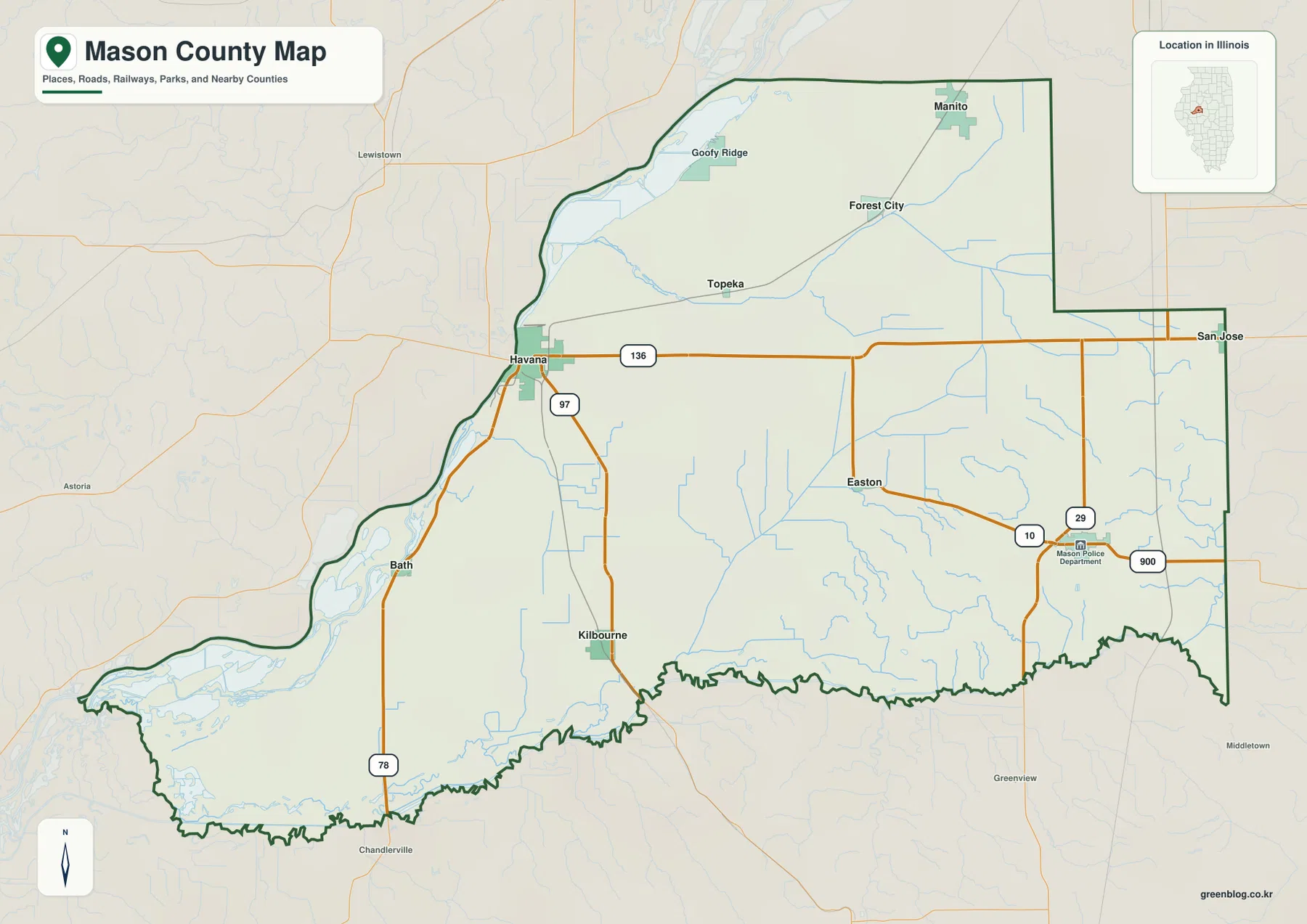
The northern communities form another pattern. Manito sits in the northeast, with Forest City and Topeka farther southwest along a separate transportation line shown on the map. Goofy Ridge is close to the northwestern river corridor. Bath, by contrast, follows the western river side south of Havana and lies closer to the lake-rich lowlands in the southwest. The map is intended for general orientation rather than live navigation, so current traffic, road closures, and travel times should still be checked with a dedicated road service.
Havana, Mason City, and Manito anchor three different parts of Mason County
The ranked city map highlights six communities. Its index lists Havana at 2,989, Mason City at 2,159, Manito at 1,692, San Jose at 557, Easton at 285, and Kilbourne at 268. The three largest highlighted places are widely separated: Havana is on the west side, Mason City is in the southeast, and Manito is in the northeast. San Jose marks the eastern boundary area, Easton sits in the east-central interior, and Kilbourne is isolated farther south.
That distribution is one of the most useful things the city map reveals. Havana belongs to a river-side environment, while Mason City is surrounded by the county’s higher southeastern terrain. Manito serves the northeastern part of the county, away from both of those larger communities. San Jose, Easton, and Kilbourne fill in the eastern and southern gaps, showing that the county’s settlements are spread over a large area instead of forming one dense urban corridor.
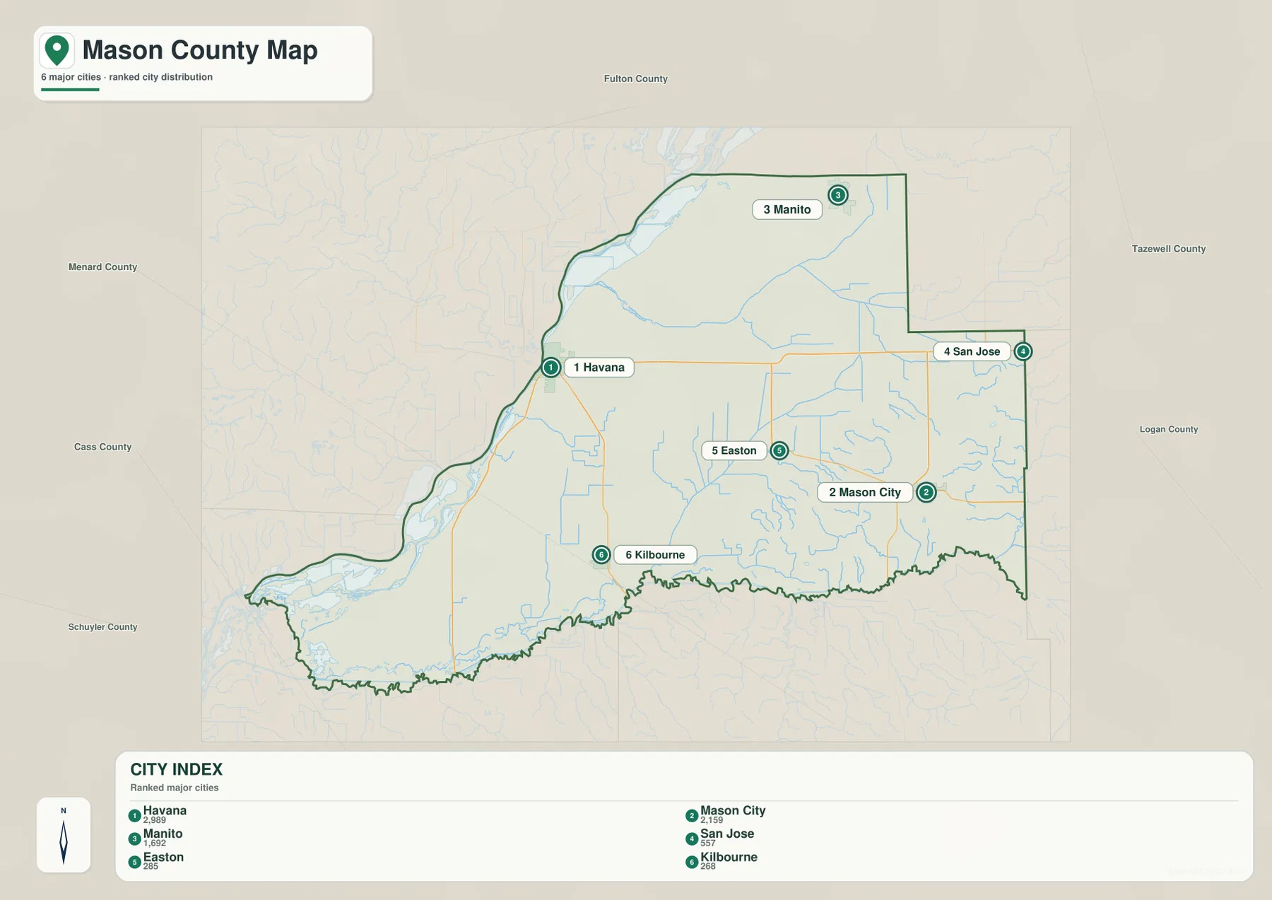
The general county map adds Bath, Topeka, Forest City, and other place labels that are not part of the ranked six. Topeka helps bridge the broad gap between Havana and the northeastern side, Forest City sits southwest of Manito, and Bath provides a lower river-side reference south of Havana. Reading the two settlement maps together gives a clearer sense of the county’s scale while keeping the ranked city view uncluttered.
Goose Lake, Quiver Creek, Sangamon River, and a chain of western wetlands
The terrain and water map is dominated by water features along the western and southwestern parts of Mason County. Goose Lake occupies a long river-side position north of Havana, and Quiver Creek enters the same lowland environment. Farther south, White Oak Creek reaches the western corridor, while Grass Lake and Jack Lake sit close together below the Bath area. These water bodies are much larger and more concentrated than the narrow drainage lines that cross the eastern interior.
The southwest contains an especially complex group of lakes, bays, and river channels. Ingram Lake, Crane Lake, Mathew Bay, Mound Lake, and Sangamon Bay are all labeled near the lower western edge, and the Sangamon River runs along the southern boundary. Mason County’s official natural hazards plan also identifies the Illinois River at Havana and lists the Sangamon River, Goose Lake, Grass Lake, Crane Lake, Mound Lake, Quiver Creek, and many other county water bodies, supporting the strong wetland-and-river pattern visible on the map.
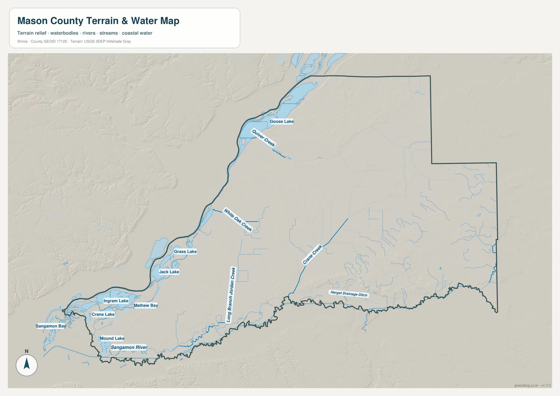
The interior has smaller named drainage lines rather than the broad lake complexes seen in the west. Long Branch Jordan Creek runs through the south-central part of the county, Crane Creek forms another inland corridor farther east, and Hergert Drainage Ditch is labeled near the southeastern boundary. These channels align with lower linear terrain on the elevation map. The water map is a geographic reference rather than a flood-risk, legal-boundary, navigation, or drainage-engineering product.
From 131 m river lowlands to 221 m high ground near the southeast
The elevation map reports an actual range of about 131 to 221 meters and a mean near 153 meters. The lowest dark greens follow the western river corridor from the Havana area south toward Bath and the broad southwestern lake country. Low terrain also continues along the southern boundary near the Sangamon River. This creates a large continuous lowland zone rather than a collection of isolated depressions.
The county’s strongest high ground is concentrated in the southeast. Brown and dark tan terrain rises south and east of Mason City, with smaller valleys cutting into its edges. The northeastern interior is generally higher than the western river side but does not reach the same elevations as the southeastern hills. In the northwest, long ridges rise directly inland from the river lowland, creating another visible contrast between the floodplain-like green corridor and the more textured interior.
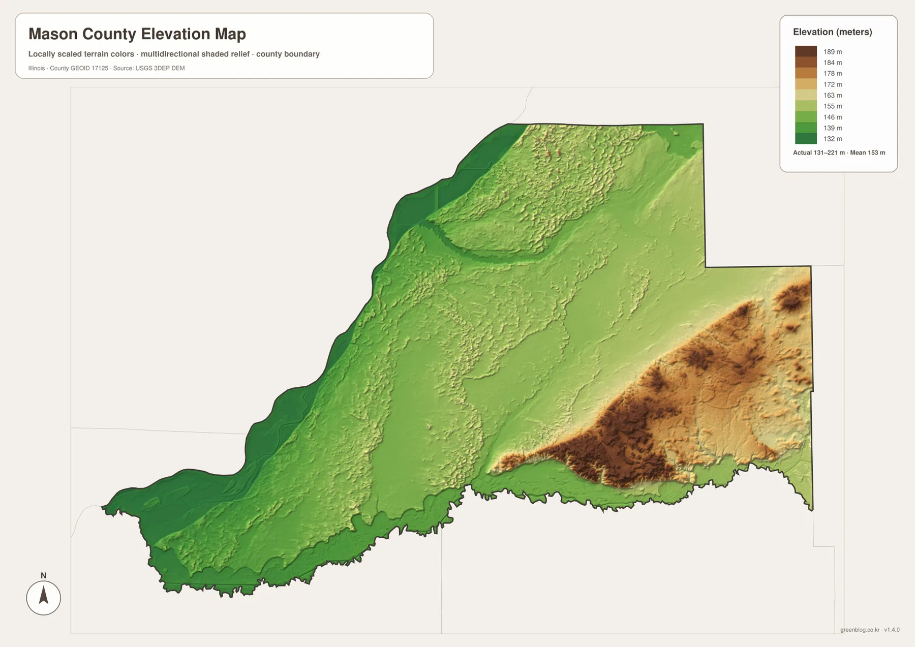
The elevation surface is generalized for county-scale comparison, not for surveying, parcel elevation, construction, or engineering design. For ordinary map reading, however, it explains why the water features are so unevenly distributed. Goose Lake, Grass Lake, and the Sangamon River sit in broad low terrain, while the Mason City side rises substantially higher. The county map then adds the roads and settlements, showing that the east-west geographic difference is both topographic and practical.
Compare Havana and Mason City across roads, water, and elevation
Use the county map when roads, boundaries, and the full set of labeled settlements matter most. The ranked city map is better for a quick comparison of Havana, Mason City, Manito, San Jose, Easton, and Kilbourne. The terrain and water map is the clearest source for Goose Lake, Quiver Creek, Grass Lake, Crane Lake, and the Sangamon River, while the elevation map explains the broad western lowlands and the much higher southeastern terrain.
Following one place across several views works especially well in Mason County. Start with Havana on the county map and note Route 136 and the western river position. Move to the water map to see Goose Lake and Quiver Creek to the north, then use the elevation map to recognize the low green corridor along the river. Mason City provides the opposite example: the city map places it in the southeast, the county map adds Routes 29 and 10, and the elevation map shows the strong rise into the county’s highest ground.
Frequently Asked Questions
What is the clearest geographic difference between Havana and Mason City?
Havana sits on the low western river side of the county, while Mason City is in the higher southeastern interior. The road map shows the large east-west separation, and the elevation map makes the terrain contrast even clearer: greens dominate around Havana and the river corridor, while brown and tan high ground rises south and east of Mason City. The water map adds another difference because the largest lake and wetland features are concentrated closer to the western lowlands.
Which map is best for Goose Lake, Quiver Creek, and the Sangamon River?
The terrain and water map is the best choice. Goose Lake is in the northwestern river corridor, Quiver Creek enters the same lowland area, and the Sangamon River runs along the southern boundary. Between them, Grass Lake, Jack Lake, Crane Lake, Mound Lake, Mathew Bay, and other named water features form a dense western and southwestern water network that is much easier to read on the dedicated water map than on the road map.
What files are included in the downloadable ZIP?
The ZIP contains four high-resolution JPG files: the county and road map, ranked city map, terrain and water map, and elevation map. Each image is 3638 × 2572 pixels. Smaller WebP versions are used in the article for faster viewing, while the JPG files are better for close inspection and print. The water and elevation maps are general geographic references rather than flood, legal-boundary, survey, or engineering products.
Map File Information
Download the Mason County county map, ranked city map, terrain and water map, and elevation map together as high-resolution JPG files.
- Included Files: Use only the versions confirmed in the article and supplied images
- File Type: Use the confirmed download contents
- Intended Use: Printing, education, presentations, and map-based projects
Related Maps
Sources and references
- U.S. Census Bureau TIGER/Line Shapefiles – county boundaries, roads, and place reference
- USGS National Hydrography – rivers, creeks, lakes, and other hydrography reference
- USGS 3D Elevation Program – elevation and terrain reference
- Mason County, Illinois official website – official county information and the Havana courthouse location
- Mason County Multi-Jurisdictional Natural Hazards Mitigation Plan – Illinois River, Sangamon River, and named county water bodies
Green Map creates custom-edited map images using open geographic data sources such as geoBoundaries, Natural Earth, OpenStreetMap, and government open data.
These maps are edited visual materials, not raw data files, and are provided for education, documents, presentations, and graphic reference.