Download four high-resolution JPG maps of Marshall County, Illinois, in one ZIP from this page, then use the article views to compare Henry, Lacon, Toluca, Wenona, the Illinois River, and the county’s striking elevation change. The Illinois River runs north-south through the county and creates a geographic divide that is visible on every map. Henry and Lacon sit close to the river, Toluca and Wenona are well to the east, and Hopewell lies on the southwestern side of the river corridor.
The difference between the two sides of the county is not only about settlement. The western third rises sharply into high, dissected uplands, while the Illinois River valley falls to the county’s lowest elevations. East of the river, a broad interior is cut by Sandy Creek, Judd Creek, and the Crow Creek branches. Marshall County Government describes the river as separating the county into roughly a western one-third and an eastern two-thirds, which matches the strong division visible in the supplied maps.
Table of Contents
Roads cross the Illinois River at Henry and follow it past Lacon
The county map is easiest to read by starting with Henry and Lacon. Henry lies near the northern edge on the east side of the Illinois River, where Route 18 crosses the river and continues east. Lacon is farther south along the river corridor, with Route 29 running close to the water. Sparland sits across the river northwest of Lacon, making the Lacon-Sparland area one of the clearest examples of the county’s east-west divide.
Farther east, the road pattern becomes more regular. Varna occupies the central-eastern area, Toluca is southeast, and Wenona is northeast near the county line. Route 17 serves the Wenona-Toluca side of the county, Route 251 leaves Wenona toward the north, Route 89 passes La Rose south of Varna, and Route 117 runs south from the Toluca area. These roads connect an inland group of towns that is geographically distinct from the river-side Henry and Lacon corridor.
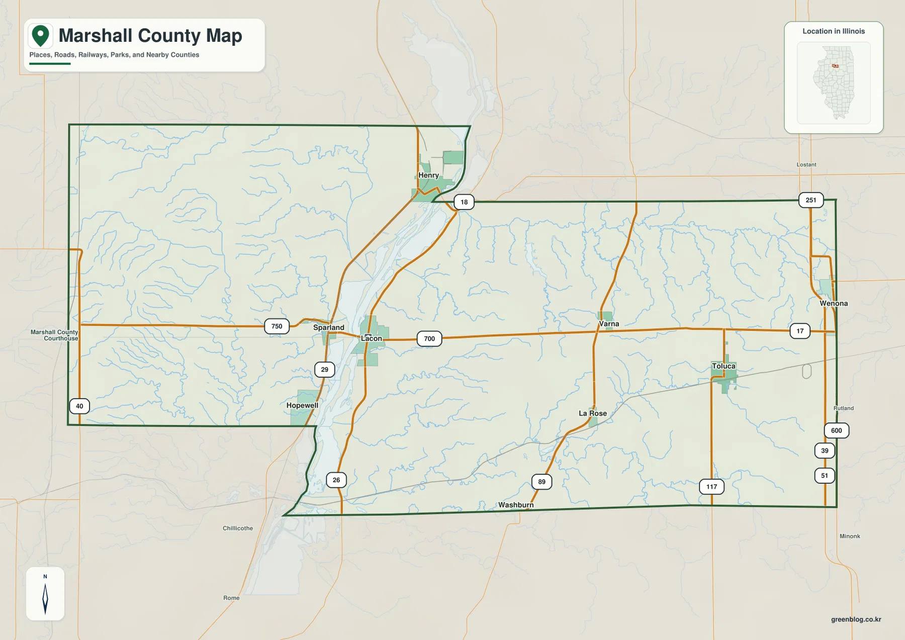
The western side is much less urbanized on the map. Hopewell sits near the southwestern river edge, while Route 40 appears along the western boundary. Numerous small streams descend through the western high ground toward the Illinois River, so roads do not form the same open grid seen across the eastern interior. For geographic orientation, the map is especially useful for checking which side of the river a place lies on and where the main crossings or river-side routes occur. Live traffic and travel times still require a dedicated navigation service.
Six highlighted cities occupy three very different parts of the county
The ranked city map highlights six communities. Its index lists Henry at 2,441, Lacon at 1,916, Toluca at 1,477, Wenona at 999, Hopewell at 604, and Varna at 387. Henry and Lacon are both tied closely to the Illinois River, but they occupy different parts of the river corridor. Toluca, Wenona, and Varna are spread across the eastern interior, while Hopewell is isolated on the southwestern side near the river lowlands.
Henry is the northern river city and sits close to the Route 18 crossing. Lacon lies farther south and serves as another river-side reference. In the east, Wenona is near the northeastern corner, Toluca is southeast, and Varna sits between them and the river. The three eastern communities therefore do not form a straight north-south line; they are separated by road corridors and numerous creek valleys. Hopewell stands apart from all five on the southwest side.
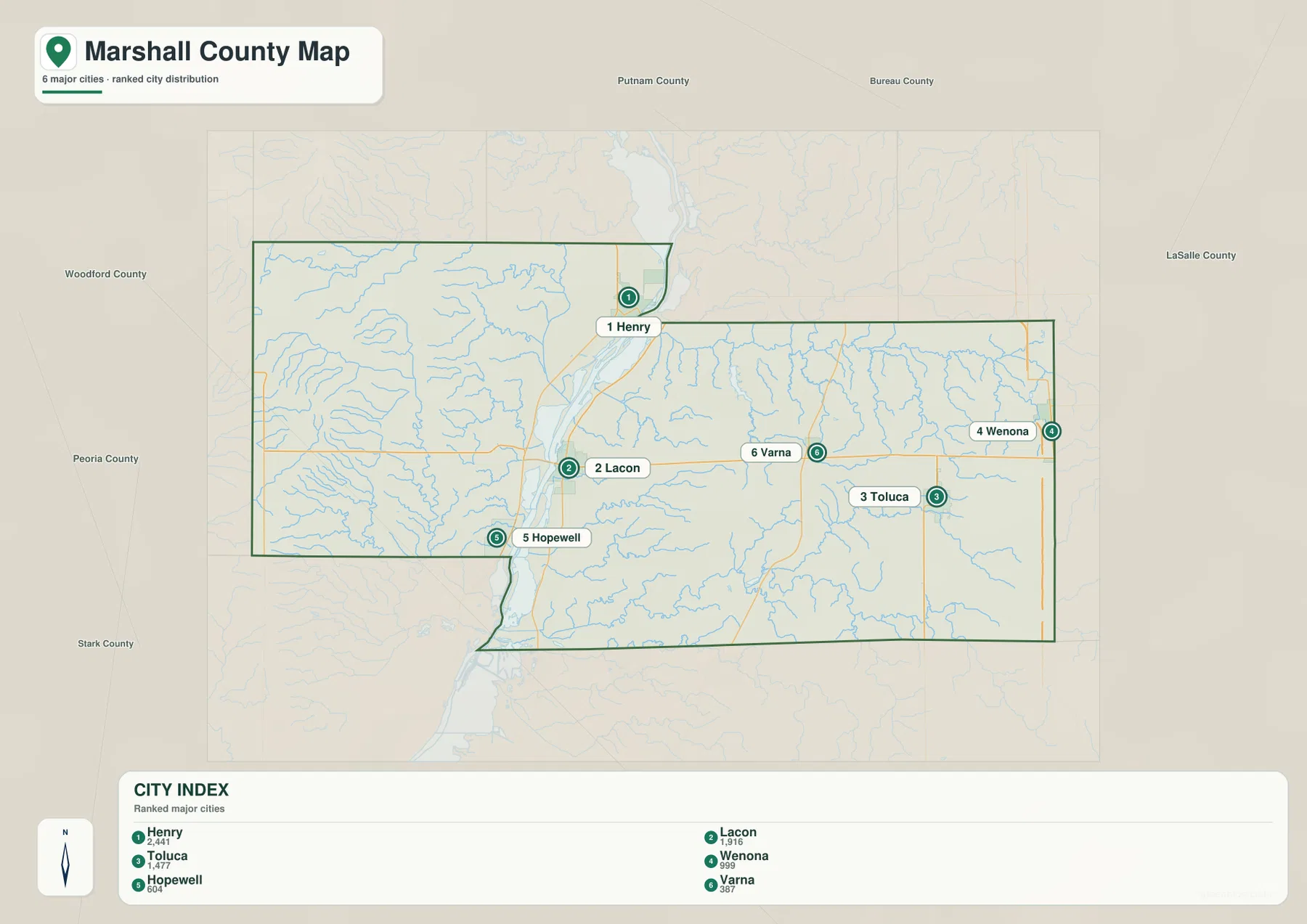
The general county map adds Sparland and La Rose, which help fill in the spaces between the six highlighted cities. Sparland sits across the river from the Lacon side, while La Rose lies south of Varna and west of Toluca. Reading the two maps together makes it easier to distinguish the county’s principal towns from smaller settlements without losing the road and river context that explains their positions.
Senachwine Creek, Crow Creek branches, and lakes on both sides of the river
The terrain and water map uses the Illinois River as its dominant feature. The river enters the county from the north, bends past the Henry-Lacon corridor, and continues south through a wide low valley. Several named lakes sit in or close to that river environment, including Billsbach Lake, Weis Lake, Goose Lake, and Wightman Lake. They provide useful landmarks for following the river corridor between the northern and southern parts of the county.
West of the river, Senachwine Creek cuts southeast through the high country toward the Illinois River. Schoales Branch is labeled farther north, and many smaller tributaries form deeply incised side valleys. This western drainage looks very different from the eastern interior because the streams descend through steeper relief before reaching the river. The elevation map confirms the same pattern with high brown uplands broken by narrow green valleys.
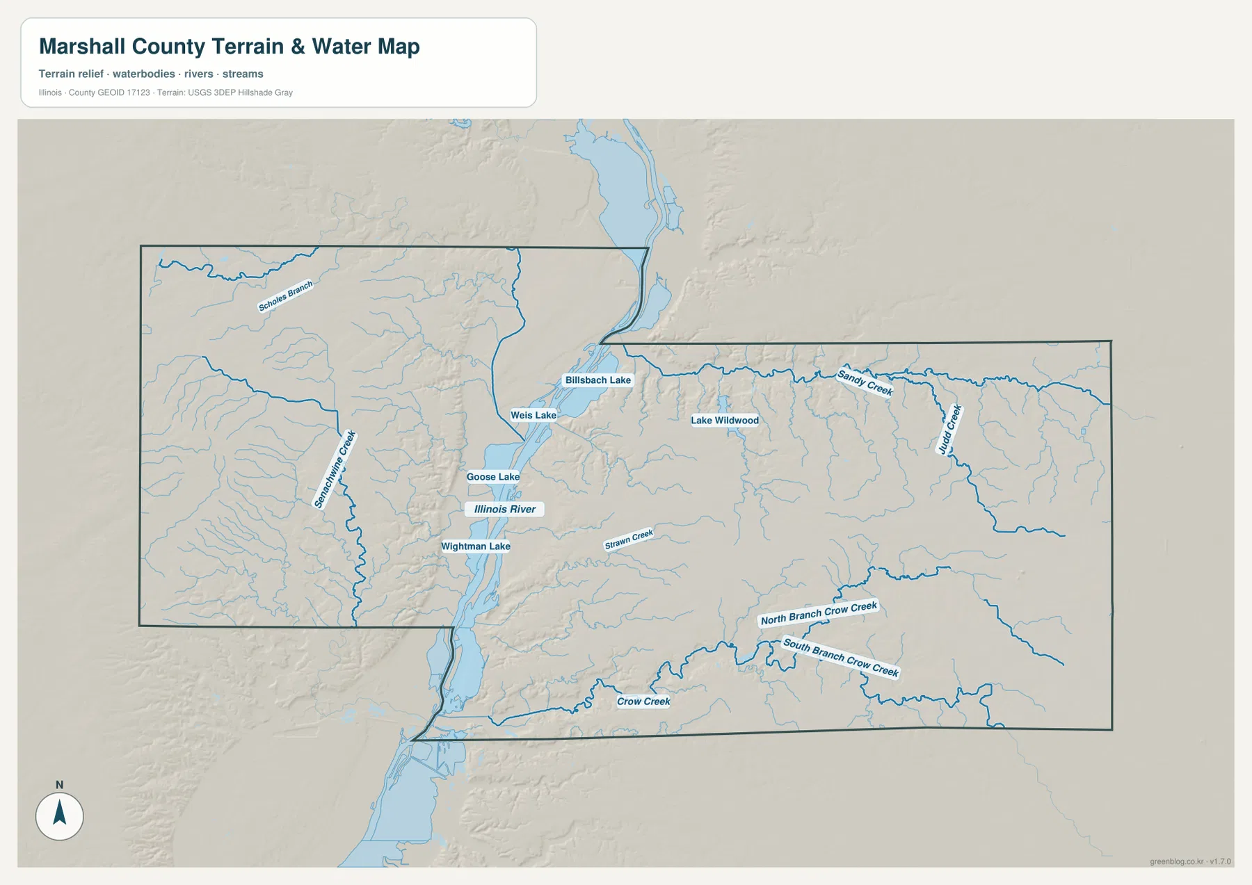
East of the river, Sandy Creek crosses the northern interior and Judd Creek drains a separate area farther south. North Branch Crow Creek and South Branch Crow Creek meet the broader Crow Creek system in the southeast, while Strawn Creek runs toward the Illinois River from the central interior. Lake Wildwood is a prominent inland water body in the northeast. The map is a geographic reference rather than a flood-risk, legal-boundary, navigation, or drainage-engineering product.
A 135–274 m county where the river valley meets high western uplands
The elevation map reports an actual range of about 135 to 274 meters and a mean near 201 meters. The lowest dark greens follow the Illinois River valley in a continuous north-south band. The western edge of the county is the exact opposite: broad brown and dark tan areas reach the highest elevations. The transition between those two zones is unusually strong for a central Illinois county because the land drops quickly from the western uplands into the river valley.
The western uplands are also heavily dissected by drainage. Senachwine Creek and many smaller tributaries carve narrow green cuts through the higher surface, creating a branching pattern that is easy to see in the hillshade. The eastern two-thirds are generally less elevated than the western high ground, but they are not flat. Sandy Creek, Judd Creek, and the Crow Creek branches cut numerous small valleys into the rolling interior before descending toward the Illinois River or leaving the county.
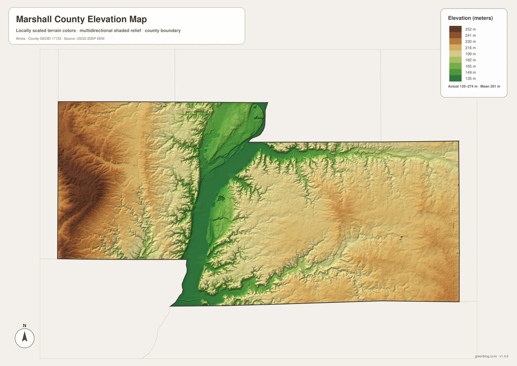
The elevation surface is generalized for county-scale comparison and should not be treated as survey-grade height, parcel elevation, or engineering data. For ordinary map reading, it is especially valuable because the large river valley and the western high ground explain many other features on the maps. Henry and Lacon occupy the river-side lowlands, while the western creeks descend sharply and the eastern towns sit on broader rolling ground separated by smaller valleys.
Compare Henry, Lacon, and the eastern towns across all four views
Use the county map first when roads, settlement labels, river crossings, and the full boundary matter most. The ranked city map is better for a quick comparison of Henry, Lacon, Toluca, Wenona, Hopewell, and Varna. The terrain and water map is the clearest source for the Illinois River, Senachwine Creek, Sandy Creek, the Crow Creek system, and the named lakes, while the elevation map explains the dramatic difference between the river lowlands and the western uplands.
Following one place across several maps works particularly well here. Start with Henry on the county map and note the Route 18 crossing, then move to the water map to see the Illinois River and nearby lakes, and finally use the elevation view to place the city beside the low river corridor. Lacon offers a similar sequence along Route 29 and the river. Toluca and Wenona provide a contrasting example because they sit well east of the river in a landscape shaped by smaller creeks rather than the main valley.
Frequently Asked Questions
Why is the Illinois River such an important reference line on a Marshall County map?
The river runs through the county from north to south and separates two clearly different landscapes. Henry and Lacon sit close to the river, high dissected uplands occupy much of the west, and Varna, Toluca, Wenona, and the Crow Creek drainage lie to the east. Marshall County Government describes the river as dividing the county into roughly a western one-third and an eastern two-thirds, so it is the most useful feature for organizing the roads, towns, waterways, and elevation.
Which map is best for comparing Henry, Lacon, and Toluca?
The ranked city map is the fastest option. Henry is near the northern Illinois River corridor, Lacon is farther south along the river, and Toluca is in the southeastern interior. Wenona occupies the northeast, Varna is central-east, and Hopewell is on the southwest side. Switch to the county map when you also want Route 18, Route 29, Route 17, Route 117, and the smaller settlements between them.
What files are included in the downloadable ZIP?
The ZIP contains four high-resolution JPG files: the county and road map, ranked city map, terrain and water map, and elevation map. Each image is 3638 × 2572 pixels. Smaller WebP versions are used in the article for faster viewing, while the JPG files are better for close inspection and print. The water and elevation maps are general geographic references rather than flood, legal-boundary, survey, or engineering products.
Map File Information
Download the Marshall County county map, ranked city map, terrain and water map, and elevation map together as high-resolution JPG files.
- Included Files: Use only the versions confirmed in the article and supplied images
- File Type: Use the confirmed download contents
- Intended Use: Printing, education, presentations, and map-based projects
Related Maps
Sources and references
- U.S. Census Bureau TIGER/Line Shapefiles – county boundaries, roads, and place reference
- USGS National Hydrography – Illinois River, streams, lakes, and other hydrography reference
- USGS 3D Elevation Program – elevation and terrain reference
- Marshall County Government – About Us – county overview and the Illinois River division through Marshall County
Green Map creates custom-edited map images using open geographic data sources such as geoBoundaries, Natural Earth, OpenStreetMap, and government open data.
These maps are edited visual materials, not raw data files, and are provided for education, documents, presentations, and graphic reference.