You can download the high-resolution LaSalle County map files on this page as one ZIP containing four JPGs. LaSalle County stretches across a large part of north-central Illinois, with the Illinois River forming the clearest geographic thread through the middle of the county. Ottawa sits near the meeting of the Fox and Illinois Rivers, while LaSalle and Peru form a close pair farther west and Marseilles extends the river corridor to the east. Mendota provides a northern reference point and Streator anchors the south. The maps below show how those places relate to major roads, waterways, and elevation.
The county becomes easier to understand when the road network and river network are read together. Interstate 80 crosses east to west just north of the main Illinois River communities. Interstate 39 and U.S. 51 provide a north-south line through the western half, linking the Mendota area with the LaSalle–Peru corridor. Water follows a different but equally important pattern: the Fox River approaches Ottawa from the northeast, the Little Vermilion system comes from the northwest, and the Vermilion River rises through the southern part of the county toward the Illinois River.
Four supplied map views cover different levels of detail. The general county map is best for roads, communities, boundaries, and selected landmarks. The ranked city map strips that information back to six highlighted population centers. The terrain-and-water map makes the Illinois, Fox, Little Vermilion, and Vermilion river systems easier to follow. Finally, the elevation map shows an actual range of about 91 to 281 meters, with a mean near 200 meters, revealing how deeply the major river valleys sit below surrounding uplands.
Table of Contents
Roads and river towns from Mendota to Ottawa, LaSalle, and Peru
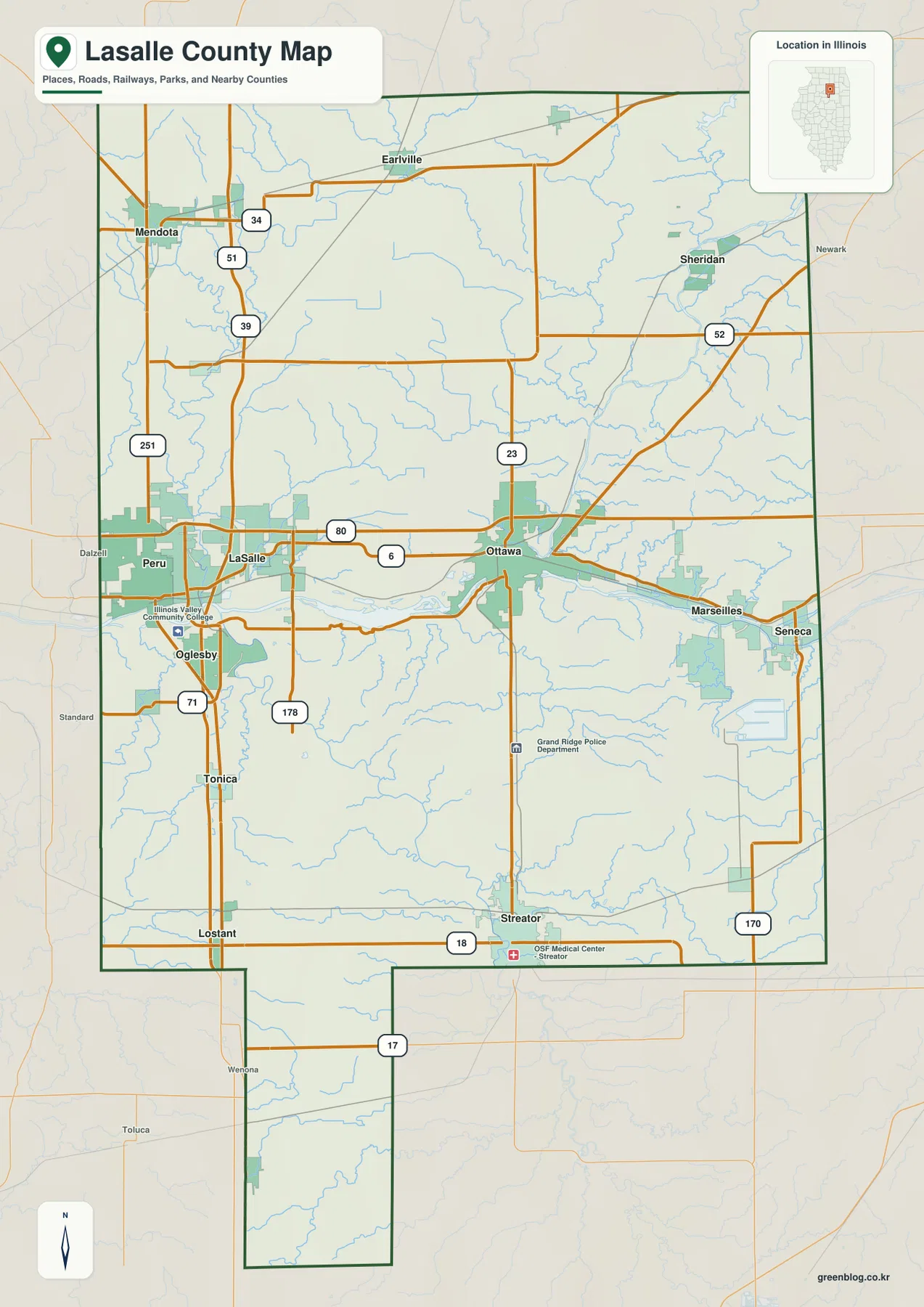
The general map makes the central river corridor the natural starting point. LaSalle and Peru sit close together on the western side of the Illinois River corridor, while Ottawa is farther east and Marseilles continues the chain beyond it. Oglesby appears south of LaSalle and Peru, with Illinois Valley Community College marked nearby. This cluster is dense compared with much of the rural interior, so identifying it first gives the reader an immediate frame for the rest of the county.
Interstate 80 runs across the county north of the river communities and gives the map a strong east-west reference. U.S. 6 stays closer to the Illinois River between the LaSalle area and Ottawa. These two routes serve different purposes on the map: I-80 is the broad cross-county line, while U.S. 6 helps connect the river towns at a more local scale. Marseilles and Seneca can then be located farther east along the same general river corridor.
The western half is organized differently. I-39 and U.S. 51 descend from the Mendota area toward I-80 and the LaSalle–Peru region, while U.S. 251 provides another north-south route farther west. Smaller places such as Tonica and Lostant appear south of the river corridor. Once those roads are recognized, the otherwise broad rural area between Mendota and the Illinois River is much easier to navigate visually.
Ottawa is a useful junction for both road and water geography. Illinois Route 23 passes north and south through the area, U.S. 6 runs across the city, and I-80 lies a short distance to the north. The county government’s offices are also located in Ottawa, reinforcing its role as an important administrative point. On the map, however, the main advantage of using Ottawa as a reference is its position between the western LaSalle–Peru cluster and the eastern communities along the Illinois River.
Northern and northeastern LaSalle County are more dispersed. Earlville is marked in the north, Sheridan lies to the northeast near U.S. 52, and Mendota sits near the northwestern edge. These places are separated by larger stretches of rural land than the river towns. The contrast is useful: the county is not dominated by one continuous urban strip, even though several of its better-known communities are concentrated near the Illinois River.
Streator is the clearest southern reference. Illinois Route 18 crosses the city, and Route 23 provides a north-south connection toward Ottawa. The county boundary also extends well south of the main river corridor in an irregular projection, so Streator does not represent the absolute southern edge by itself. The general map is especially helpful here because it shows the unusual county outline together with the road system.
Six highlighted cities reveal a county with several separate centers
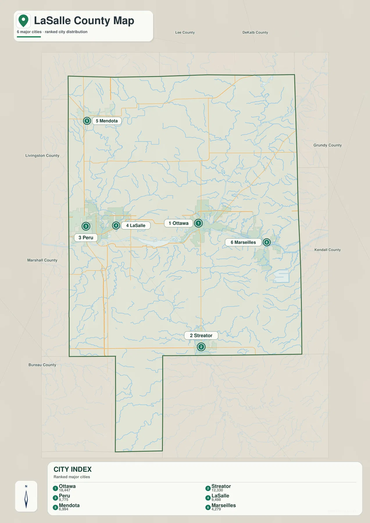
The city map removes most of the road detail and focuses on six labeled centers. Ottawa occupies the central-eastern river corridor. Peru and LaSalle form a close pair to the west, while Marseilles lies east of Ottawa. Streator is separated from that group to the south, and Mendota stands apart in the northwest. The pattern is useful because it prevents the common assumption that all of the county’s larger communities sit along one straight riverfront line.
The CITY INDEX printed on the map lists Ottawa at 18,447 and Streator at 12,330. Peru is shown at 9,775, LaSalle at 9,498, Mendota at 6,994, and Marseilles at 4,279. These figures should be treated as reference values embedded in the supplied map rather than as a claim about the latest official population. For current demographic work, the Census Bureau or the relevant municipal source should be checked separately.
Peru and LaSalle are the closest pair among the six highlighted places, and the general map shows how tightly their road networks overlap. Ottawa is separated to the east but remains part of the same broad Illinois River corridor. Marseilles extends that river-oriented settlement pattern farther downstream. This west-to-east sequence is one of the most practical ways to describe the central part of the county without reducing all of its communities to a single metro area.
Mendota and Streator provide the strongest contrast. Mendota is tied to the northern I-39/U.S. 51 corridor, whereas Streator belongs to the southern part of the county and sits closer to the Vermilion River drainage. Their separation shows the county’s large north-south reach. A reader using only the Ottawa–LaSalle–Peru cluster could easily underestimate how much territory lies beyond the Illinois River corridor.
The ranked map intentionally leaves out smaller communities that remain useful on the general map, including Earlville, Sheridan, Oglesby, Tonica, and Lostant. That is why the two maps work best as a pair. The city map establishes the broad pattern, then the general map restores the road numbers and additional place names needed for more detailed orientation.
The Illinois River gathers water from the Fox, Little Vermilion, and Vermilion systems
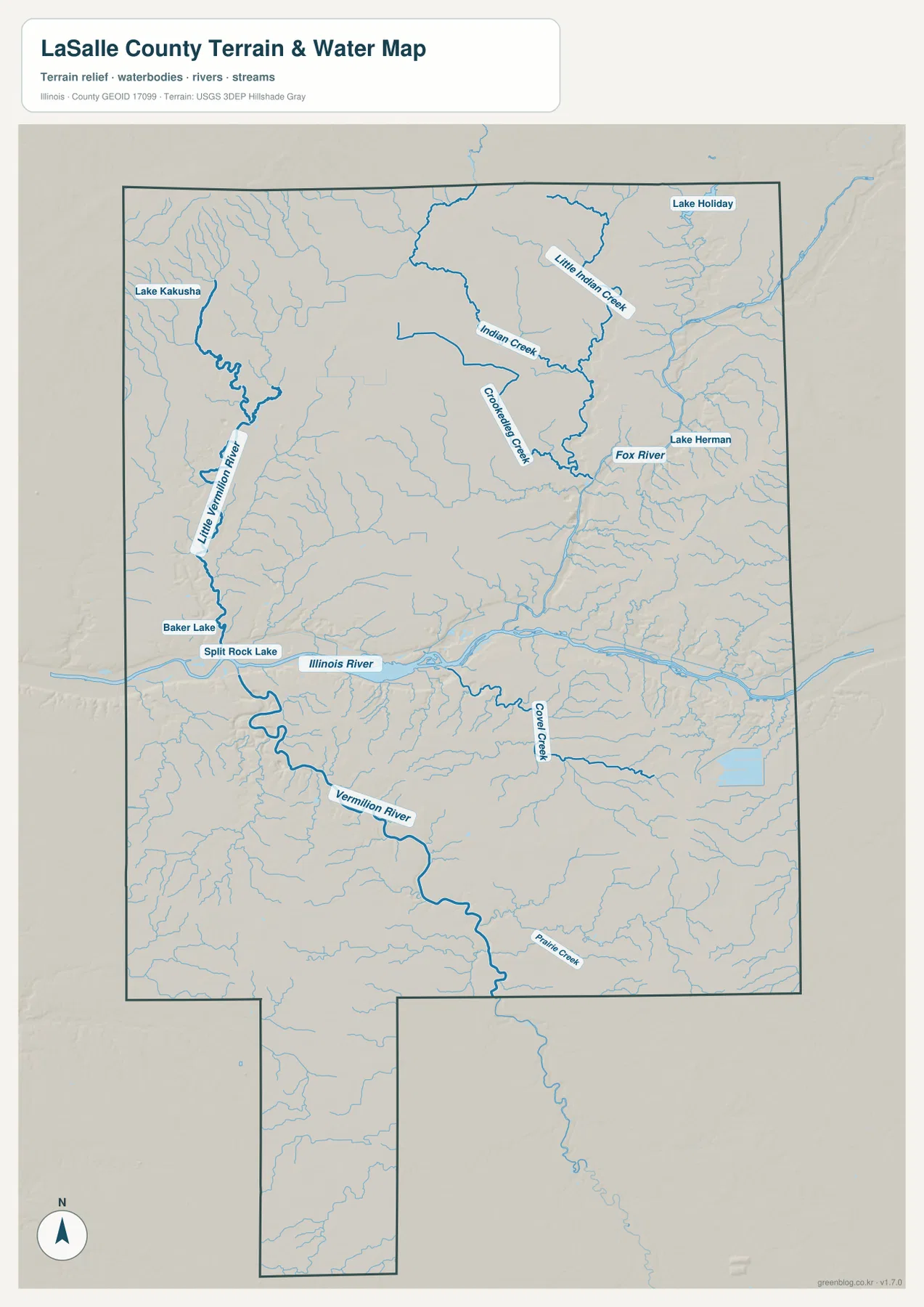
The Illinois River dominates the water map. It crosses the middle of LaSalle County from east to west and receives water from several distinct directions. The county’s comprehensive plan identifies it as the principal surface-water body in the county and names the Fox, Little Vermilion, and Vermilion Rivers among its important tributaries. That official description matches the visual pattern on the supplied map: one broad central river with several large branches feeding into it.
The Fox River enters from the northeast and meets the Illinois River at Ottawa. Smaller channels such as Little Indian Creek, Indian Creek, and Crookedleg Creek are visible in the same northeastern system. Because roads are largely removed from this view, the drainage paths stand out more clearly than they do on the general map. Comparing the two images explains why Ottawa is such a strong geographic reference point: it sits where a major tributary reaches the county’s main river corridor.
In the northwest, the Little Vermilion River follows a separate route toward the Illinois River. Lake Kakusha is marked near the northwestern side, while Baker Lake and Split Rock Lake appear closer to the central river corridor. These features are not as large as the Illinois River, but they help show that the western half of the county contains multiple connected water systems rather than one isolated channel.
The Vermilion River approaches from the south and reaches the Illinois River near the LaSalle area. Its valley is one of the most obvious north-south features on both the water and elevation maps. Crow Creek and Prairie Creek add smaller branches in the southern half. Streator sits within this broader southern landscape, so the water map gives useful context that is missing from the simplified ranked city view.
Lake Holiday and Lake Herman appear in the northeastern part of the map. They are much smaller than the main river system, but they are valuable location markers when reading the Sheridan side of the county. The northeastern network also looks more finely divided, with many small stream lines converging toward larger channels. This is a good example of why a water-focused map can reveal structure that is easy to overlook beneath road labels.
This map is intended for regional orientation, not legal or real-time water decisions. It does not establish floodplain boundaries, wetland jurisdiction, current river stage, or water quality. LaSalle County’s official GIS tools and current USGS data are the appropriate sources for those questions. For a classroom, report, trip plan, or general county overview, the supplied water map is most useful for showing where the major rivers meet and how the tributary valleys divide the landscape.
A 91–281 meter elevation range emphasizes the broad river valleys
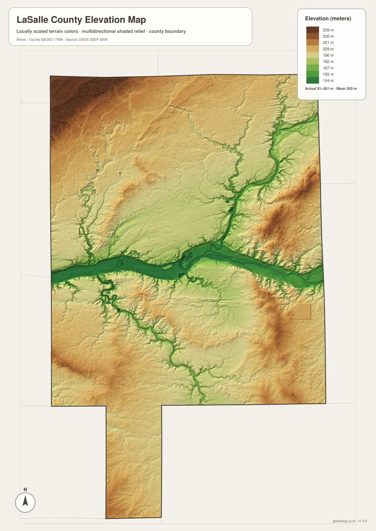
The elevation map uses an actual county range of roughly 91 to 281 meters, with a mean near 200 meters. The strongest feature is the low Illinois River valley, which forms a broad green band across the center. Its width is much more obvious here than on the road map. The central towns occupy or sit close to this low corridor, making the elevation view a useful companion to the settlement map.
The Fox River valley cuts in from the northeast as a narrower low corridor and meets the Illinois River around Ottawa. Numerous small tributary ravines branch outward from it. Those branches explain the thin green lines visible among higher yellow and brown areas. Reading the water map first makes the relief image easier to interpret, because the valleys can be matched to named streams rather than treated as anonymous color changes.
South of the Illinois River, the Vermilion River produces another strong valley extending toward the county’s southern interior. It is not as broad as the Illinois River lowland, but it is one of the clearest north-south depressions on the map. Smaller valleys feed into it, giving the southern half a more dissected appearance than the general road map suggests.
Higher ground becomes more common away from the main river valleys. Brown and darker tan areas are especially noticeable along portions of the eastern and western interior, with additional elevated patches in the north. LaSalle County is not mountainous, yet the contrast between valley floors and uplands is large enough to be obvious at county scale. The 91–281 meter range therefore tells a more varied story than a flat road map alone.
The elevation pattern also helps distinguish communities that appear close on a simple map. Ottawa, LaSalle, Peru, and Marseilles belong to the low Illinois River corridor. Mendota sits farther into the higher northwestern interior, while Streator is connected to the southern Vermilion valley. Looking back at the road network after studying the relief makes those positions easier to remember.
This generalized elevation map is not a substitute for surveying or site engineering. A building pad, drainage design, property corner, or flood determination requires source elevation data and project-specific measurements. The county-scale map is best used to compare broad terrain zones: low river bottoms, branching stream valleys, and the higher land between them.
Which LaSalle County map is best for roads, water, terrain, or printing?
For a first look, begin with the general county map. Locate the Illinois River, then find LaSalle, Peru, Ottawa, and Marseilles along the central corridor. Add Mendota in the northwest and Streator in the south. Once those anchors are established, I-80, I-39, U.S. 6, U.S. 51, and the numbered state routes become much easier to place in context.
The ranked city map is the quickest choice when the question is simply where the six highlighted centers sit relative to one another. It clearly separates the western LaSalle–Peru pair from Ottawa and Marseilles, then shows how far Mendota and Streator lie from the central river cluster. Use the general map instead when secondary communities, route numbers, and selected landmarks matter.
For rivers and lakes, move directly to the terrain-and-water view. Start with the Illinois River, then trace the Fox River from the northeast, the Little Vermilion from the northwest, and the Vermilion from the south. Follow with the elevation map to see the valleys carved by those same systems. Using the two maps in sequence turns the drainage network into a recognizable terrain pattern.
The WebP images in the article are optimized for quick viewing on a screen. For closer inspection of road labels, stream names, presentations, or larger prints, use the ZIP below. It contains the original high-resolution JPG versions of the general county map, ranked city map, terrain-and-water map, and elevation map.
Frequently Asked Questions
Which map is easiest for comparing Ottawa with LaSalle and Peru?
Use the general county map first. It shows the Illinois River, I-80, U.S. 6, and the three communities together, making the west-to-east relationship easy to see. The ranked city map is a useful second view when you want to remove most road detail and compare only the highlighted population centers.
Where can I see the Fox and Vermilion Rivers joining the Illinois River system?
The terrain-and-water map is the clearest choice. The Fox River approaches Ottawa from the northeast, while the Vermilion River comes from the south toward the LaSalle area. The Little Vermilion system also enters from the northwest, so the map shows how several large tributary directions converge on the central Illinois River.
Can the 91–281 meter elevation range be used for construction or surveying?
No. The elevation map is a county-scale visualization for comparing low river valleys with higher interior ground. Exact site elevations, drainage design, flood determinations, and property work require appropriate source data, project measurements, or professional surveying.
Map File Information
The original high-resolution JPG maps for LaSalle County are bundled into one ZIP for easier saving, zooming, printing, and presentation use.
- Included Files: 4 high-resolution JPG images
- File Type: ZIP archive containing JPG images
Related Maps
Sources and references
- U.S. Census Bureau TIGER/Line Shapefiles – official geographic source for county boundaries, roads, and related mapped features.
- USGS National Hydrography – official USGS information for rivers, streams, lakes, and other surface-water features.
- USGS 3D Elevation Program – official USGS source for elevation and terrain data.
- LaSalle County GIS Maps – official county page for GIS, zoning, flood, parcel, and PDF map resources.
- LaSalle County Comprehensive Plan – official county planning document describing the Illinois River and major tributary systems, local geography, and land-use context.
Green Map creates custom-edited map images using open geographic data sources such as geoBoundaries, Natural Earth, OpenStreetMap, and government open data.
These maps are edited visual materials, not raw data files, and are provided for education, documents, presentations, and graphic reference.