Effingham County in south-central Illinois is easiest to understand from the road crossroads at Effingham. The county seat sits near the meeting of I-57 and I-70, with Altamont to the west, Teutopolis to the east, Dieterich to the southeast, and Watson and Mason extending southward. Away from those straight transportation lines, Little Wabash River and the Salt Creek system cut a much more irregular set of valleys through the county. You can download the high-resolution JPG originals directly from this page in one ZIP file; the files are suitable for larger on-screen viewing, printing, class materials, and presentation slides.
Several lakes help break up the drainage pattern. Lake Sara stands west of Effingham, while Lake Pauline and Cips Lake lie closer to the central Little Wabash corridor. Around Altamont, Altamont Reservoir and Old Altamont Reservoir provide additional landmarks. The elevation image adds another layer: broad higher ground occupies the northwest and north-central county, then drops into lower green channels along the Little Wabash, Salt Creek, and their tributaries.
Illinois State Archives records Effingham County as legally established on February 15, 1831, with the county organization beginning after later legislation in 1832. Ewington served as the county seat from 1833 to 1860, when Effingham became the seat and has remained so. The county’s present government offices are also in Effingham, making the city both the administrative and transportation anchor for the map set.
Table of Contents
Interstates make Effingham the main road reference
Effingham is the strongest urban and highway center on the overview. I-57 runs north-south through the county and continues toward Watson and Mason, while I-70 approaches from the Altamont side before crossing the Effingham area and continuing east. U.S. 40 adds another east-west route through Altamont, Effingham, and the Teutopolis side, tying several of the largest mapped communities together.
Northwest of Effingham, routes labeled 32 and 33 descend from the Shumway direction. Teutopolis lies immediately east of Effingham, with Montrose farther toward the northeastern boundary. Dieterich occupies the southeast, and the long southern road corridor passes Watson before reaching Mason and the Edgewood side. Beecher City in the northwest and Altamont in the west provide useful outer references for the county’s width.
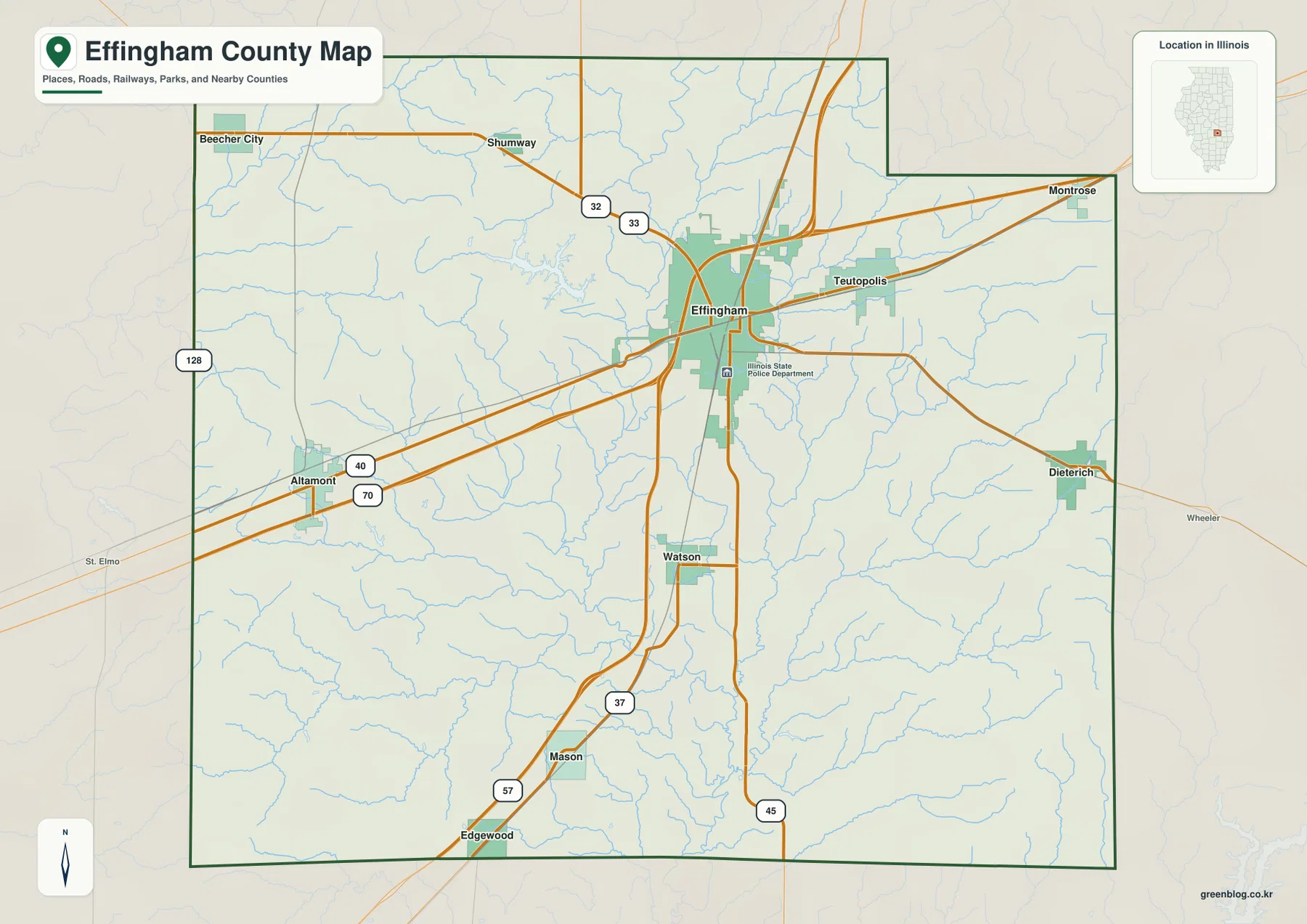
An Illinois State Police Department label appears on the south side of the Effingham urban area, and rail lines also pass through the central corridor. The built-up center therefore looks much denser than the surrounding countryside. Just outside it, blue tributaries repeatedly cross the road grid, especially west and south of Effingham. The contrast between straight highways and winding stream valleys is one of the easiest ways to see that the county’s surface is more varied than the road map alone suggests.
Effingham has been the county seat since 1860
Illinois State Archives lists Ewington as the county seat from 1833 through 1860 and Effingham from 1860 to the present. Current county offices and the courthouse are also in Effingham. That long-standing administrative role makes the city an especially useful fixed reference when switching between the road, city, water, and elevation maps.
Six city markers show a central hub with west, east, and southern branches
The simplified city graphic gives Effingham the largest marker and Altamont the second-largest. Teutopolis is third, Dieterich fourth, Watson fifth, and Mason sixth. The printed CITY INDEX lists 12,342 for Effingham, 2,282 for Altamont, 1,729 for Teutopolis, 1,169 for Dieterich, 620 for Watson, and 467 for Mason.
The image does not show a census year or statistical reference date, so this article does not treat those numbers as current population counts. Their placement is more useful for orientation. Effingham sits near the center, Altamont extends the pattern west, Teutopolis and Dieterich lie to the east and southeast, and Watson with Mason form a southern line.
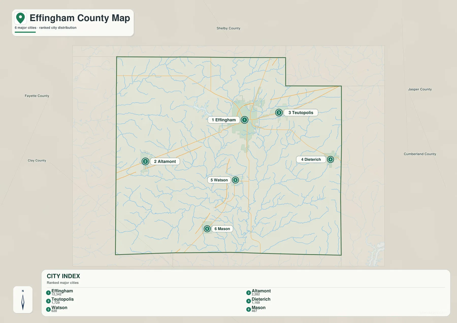
The selected-city view is especially helpful because it removes most minor roads and streams. Altamont and Dieterich sit on opposite sides of the county, while Teutopolis remains close to Effingham. Watson and Mason line up to the south, echoing the I-57 direction on the overview. Once those six locations are familiar, the detailed county map becomes much easier to navigate.
The CITY INDEX is undated map data
Current population figures should come from a source that states its reference year, such as the U.S. Census Bureau. The supplied city graphic does not identify when its index values were measured, so this page uses them only to describe the ranking and relative marker sizes shown on the image.
Lake Sara and Little Wabash River organize the central water map
Little Wabash River is the strongest named channel through the middle of the terrain-and-water map. It descends from the north, passes near Lake Pauline and Cips Lake, and continues south as tributaries join the main low corridor. Fuller Creek and Big Creek approach from the west, helping connect the Altamont side to the central river valley.
East of the Little Wabash, Salt Creek forms another long north-south route. Big Salt Creek enters from the northeast, Bishop Creek joins the eastern drainage farther south, and Ramsey Creek crosses the lower southeastern area. Wolf Creek is labeled in the northwest. Around Altamont, 2nd Creek runs near Altamont Reservoir and Old Altamont Reservoir before the drainage turns toward the county interior.
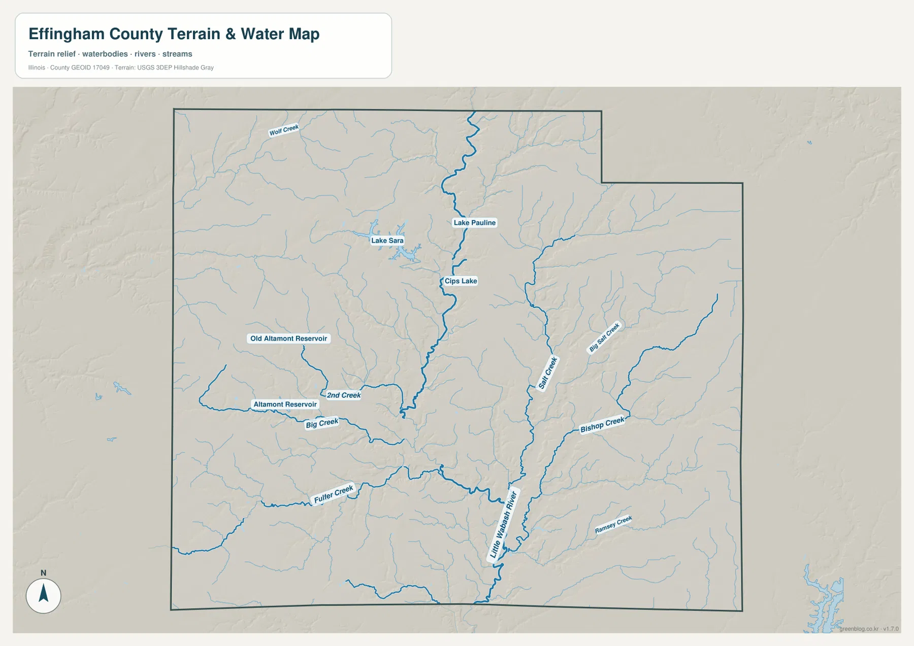
Lake Sara is the most distinctive lake on the western side. An Illinois DNR county plan describes it as an approximately 800-acre lake created in the 1950s as a backup water supply for Effingham and as a recreational resource. On the supplied map, it stands apart from the main Little Wabash channel and gives the northwest-central part of the county an easy visual landmark, while Lake Pauline and Cips Lake sit closer to the river corridor.
The water map does not show live river or lake conditions
The terrain sheet is designed to show where rivers, creeks, lakes, and reservoirs sit relative to county relief. It does not report current Little Wabash River stage, flood-hazard boundaries, lake depth, boating rules, or access conditions. For present-day safety or water use, check current USGS, Illinois DNR, and other responsible local information.
Northwest uplands drop into the Little Wabash and Salt Creek valleys
The elevation image places the broadest high ground in the northwest and north-central county. Brown and orange uplands are repeatedly cut by narrow green tributary valleys. Toward the center, Little Wabash River occupies a much wider low corridor, and Salt Creek creates another green route farther east. The southern half is generally lower than the northern uplands, although smaller ridges still appear between the creek valleys.
The map reports an actual countywide elevation range of about 141 to 207 meters and a mean near 176 meters. Its color legend uses narrower bands from roughly 150 to 195 meters, while the separate “Actual” line records the wider minimum and maximum of the dataset. Those endpoints describe Effingham County as a whole and should not be assigned directly to Effingham, Watson, Mason, Beecher City, or any individual property.
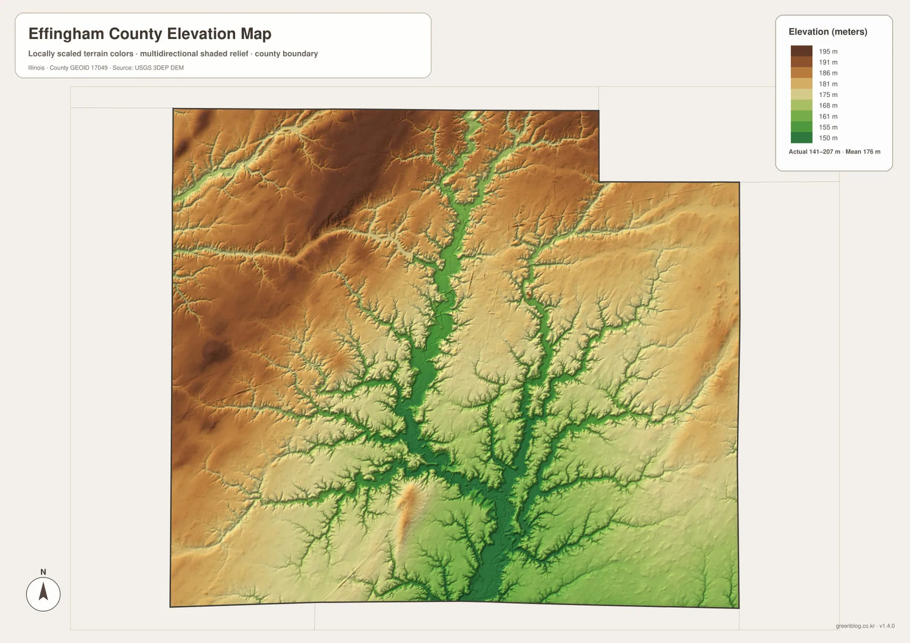
Comparing the elevation and water sheets makes the green lowlands easier to interpret. Little Wabash River and Salt Creek occupy the longest connected low corridors, while Big Creek, 2nd Creek, and Fuller Creek carve narrower valleys into the higher western ground. The road map makes much of the county look orderly and open; the elevation layer shows how strongly the streams have divided that surface.
141 to 207 meters is a countywide range
A building site, road grade, drainage plan, or parcel needs point-specific elevation data or a professional survey. The 141–207 meter range is most useful for comparing Effingham County’s uplands and stream valleys, not for assigning an exact elevation to a named town or address.
Keep Effingham fixed while switching between roads, lakes, water, and relief
A practical way to use the files is to keep Effingham fixed as the main anchor. On the overview, separate the I-57 north-south direction from the I-70 and U.S. 40 east-west corridor, then add Altamont, Teutopolis, Dieterich, Watson, and Mason around the city. The simplified city view confirms those same directions without the smaller roads and tributaries.
Next, locate Lake Sara west of Effingham and Little Wabash River through the county center, then add Salt Creek to the east. The elevation map completes the picture by showing higher northwest ground above the central and southern valleys. Using the same landmarks across the files keeps roads, settlements, lakes, drainage, and relief connected instead of treating each map as an isolated view.
Use current transportation information for real travel, dated Census data for population, current agency information for river or lake conditions, and point-level elevation or survey data for site work. Within those limits, the Effingham County maps are useful for printed references, lessons, presentations, and advance geographic orientation.
Frequently Asked Questions
What is the county seat of Effingham County, Illinois?
Effingham is the county seat. Illinois State Archives lists Ewington as the seat from 1833 to 1860 and Effingham from 1860 to the present.
Is Lake Sara a natural lake?
An Illinois DNR county plan describes Lake Sara as an approximately 800-acre lake built in the 1950s for backup water supply and recreation. On the supplied water map, it is the clearest lake landmark west of Effingham.
Does 141 to 207 meters give Effingham city’s elevation?
No. The elevation image identifies 141–207 m as the actual range across the Effingham County dataset and gives a mean of about 176 m. Exact elevation for Effingham or any specific road, building, or property requires point-specific elevation or survey data.
Sources and Reference Material
The article uses the supplied Effingham County maps together with the official references below. For current roads, river stages, lake rules, legal boundaries, or exact point elevations, use the latest information from the agency responsible for that subject.
- Effingham County Official Website – current county government and Effingham administrative information
- Illinois State Archives – Effingham County – county establishment and Ewington-Effingham county-seat history
- Illinois DNR – Effingham County Comprehensive Plan – Lake Sara and local transportation/recreation context
- USGS National Hydrography – river, stream, lake, and reservoir reference data
- USGS 3D Elevation Program – elevation and terrain data
Map File Information
The ZIP file contains the high-resolution JPG originals for the Effingham County overview, city map, terrain-and-water map, and elevation map. Each landscape image measures 3,638 × 2,572 pixels, keeping road labels, town names, smaller creek names, and relief colors easier to read when enlarged or printed.
- Included Files: 4 high-resolution JPG maps
- Printable Size: 3,638 × 2,572 pixels each
Related Maps
Green Map creates custom-edited map images using open geographic data sources such as geoBoundaries, Natural Earth, OpenStreetMap, and government open data.
These maps are edited visual materials, not raw data files, and are provided for education, documents, presentations, and graphic reference.