Edwards County in southeastern Illinois is easiest to orient around Albion. The county seat sits slightly south of center, with West Salem well to the north, Bone Gap and Browns to the east, and Grayville near the southeastern end of the county. Little Wabash River forms the strongest water reference on the west, while Bonpas Creek follows a long low corridor on the east. High-resolution JPG originals of the supplied maps are bundled in one ZIP download for printing, enlargement, classroom use, or presentations.
The county is small enough to learn quickly, but its terrain is not flat or uniform. Short ridges rise through the north-central and middle parts of the county, then break into creek valleys toward both sides. West Salem Reservoir, Krajec Lake, and Moose Lake provide smaller fixed water landmarks. On the elevation image, the broad river and creek lowlands contrast sharply with the higher interior ridges.
Illinois State Archives records Edwards County as established on November 28, 1814. Palmyra served as the county seat until 1821, when Albion became the seat and has remained so. The current Edwards County Courthouse is also located in Albion, making the town both the administrative center and the most useful anchor on the supplied maps.
Table of Contents
Albion and Route 15 give the county its main road reference
Albion is the clearest road center on the county overview. Route 15 crosses the town and continues east toward Browns, reaching the county’s irregular eastern edge. Route 130 leaves the Albion area toward the southeast and leads into the Grayville side of the county, where Routes 1 and 12 are also labeled. With relatively few large highways, the Route 15 line is a useful first step for learning the map.
West Salem lies far north of Albion, while Bone Gap occupies the eastern-middle county between West Salem and the Route 15 corridor. Browns sits close to Albion on the east-west road, and Grayville reaches toward the southeastern tip. Local numbered roads such as 200, 300, and 500 extend through the western and central interior, connecting the smaller rural areas to the main towns.
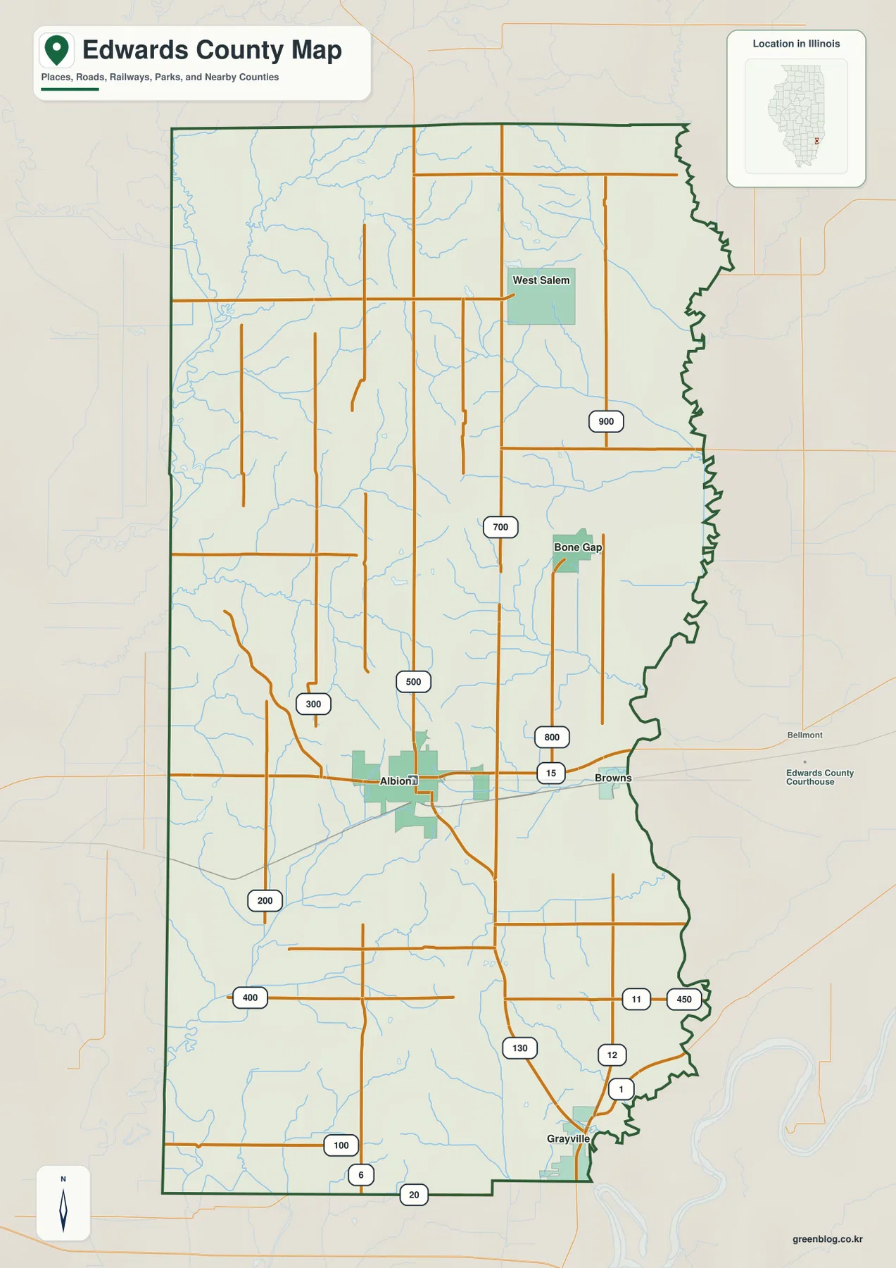
Official county planning material places Richland County to the north, Wayne County to the west, White County to the south, and Wabash County to the east. The eastern boundary is visibly irregular on the supplied map and sits close to the Bonpas Creek lowland. On the western side, Little Wabash River and its tributaries form another long low corridor. Those outer features help explain why the interior roads can look orderly while the county edge and stream valleys are much more winding.
Albion has been the county seat since 1821
Illinois State Archives lists Palmyra as the county seat from 1814 to 1821 and Albion from 1821 to the present. The current courthouse address is also in Albion. This makes Albion more than the geographic hub on the map: it is the long-standing administrative center as well.
Straight-line distances from Albion show how far the main villages spread
The city-connections graphic uses Albion as the hub. West Salem is shown about 11 miles to the north, Bone Gap about 6 miles to the northeast, and Browns about 4 miles to the east. The panel explicitly labels these as direct distances, so they represent straight-line separation between mapped points rather than road mileage or estimated drive time.
The same panel prints CITY CONNECTIONS values of 2,001 for Albion, 713 for West Salem, 220 for Bone Gap, and 163 for Browns. The graphic gives no date or census reference for those CITY CONNECTIONS values. This article therefore treats them only as undated map values, not as current population counts. The direction and direct-distance labels are the more reliable geographic information.
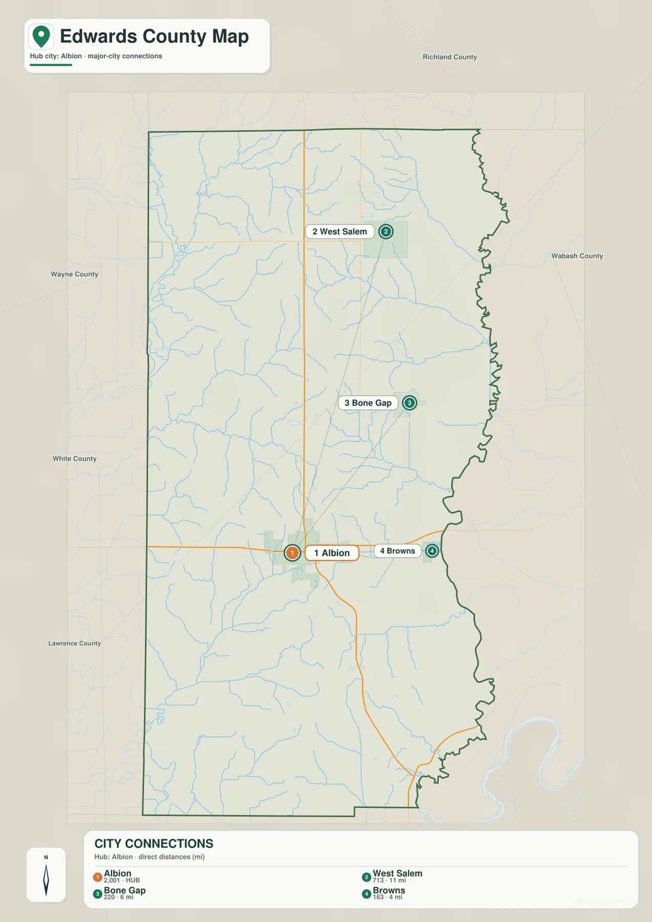
The spacing explains the county’s settlement pattern better than the undated index values alone. Albion and Browns are relatively close, Bone Gap is farther into the eastern-middle county, and West Salem is well separated to the north. Actual driving mileage can be longer than the drawn segments because local roads do not follow a straight path between each pair.
Direct distance and CITY CONNECTIONS values have different uses
The 11-, 6-, and 4-mile labels are straight-line distances from Albion, while the four CITY CONNECTIONS numbers are undated values printed on the map. Use a current routing source for road mileage and a dated Census release for present-day population.
Little Wabash and Bonpas Creek frame the county waterways
Little Wabash River is the strongest named water feature on the western side of the terrain map. Fox River descends through the northwest, with Sugar Creek feeding the same general lowland. Bear Creek, West Village Creek, and Village Creek cut additional valleys through the western half before reaching the broader Little Wabash side.
The eastern county has a different drainage pattern. Bonpas Creek follows a long north-south corridor, Crooked Creek descends through the northeast, and Walser Creek approaches the eastern lowland from the central interior. Indian Creek lies farther south, while Big Creek creates another strong channel in the southwest. Together these waterways divide the county into a series of ridges and low corridors rather than one uniform plain.
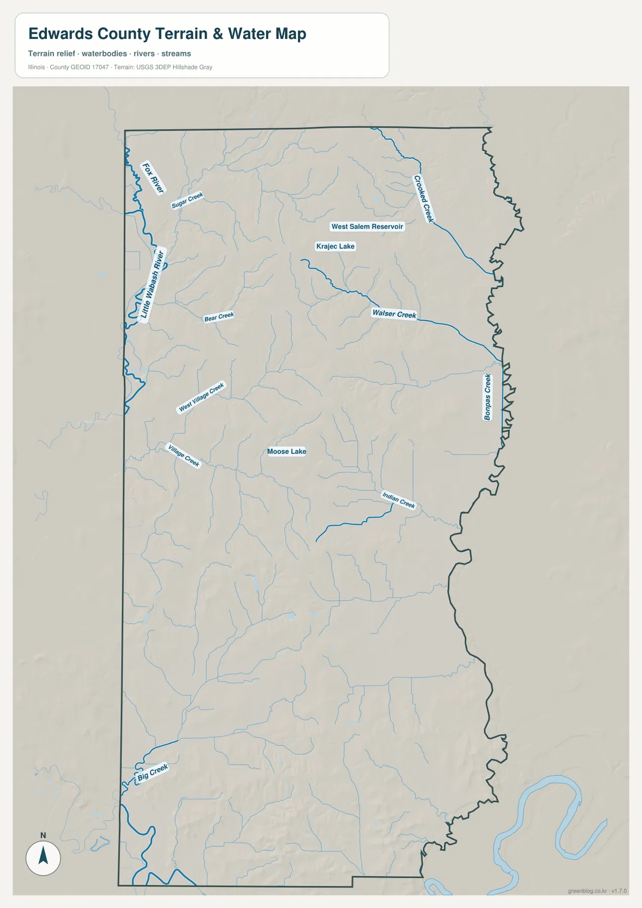
West Salem Reservoir and Krajec Lake sit in the northern county, surrounded by a dense set of short tributaries. Moose Lake appears nearer the center. The lakes are useful reference points, but the broader terrain story comes from the creeks around them: the small water bodies sit within branching valleys that connect the higher interior ground to the larger river and creek lowlands.
The water map is not live flood or river-stage information
The terrain sheet is designed to show where rivers, creeks, reservoirs, and lakes sit relative to county relief. It does not report current Little Wabash River or Bonpas Creek stage, flood-hazard boundaries, water depth, fishing rules, or access conditions. Present-day safety or water-use questions should be checked against current USGS and responsible local or state information.
Interior ridges rise between the western and eastern lowlands
The elevation image shows the strongest high terrain in the north-central and central parts of Edwards County. Brown and orange ridges are repeatedly cut by narrow green tributary valleys. Additional high ground appears in the southwest and south, while the Little Wabash side in the west and the Bonpas Creek side in the east remain broadly lower.
The map reports an actual countywide elevation range of about 111 to 180 meters and a mean near 134 meters. Its color legend uses narrower bands from roughly 115 to 158 meters, while the separate “Actual” line records the broader minimum and maximum in the dataset. Those endpoints describe Edwards County as a whole and should not be assigned directly to Albion, Browns, Grayville, West Salem, or any individual property.
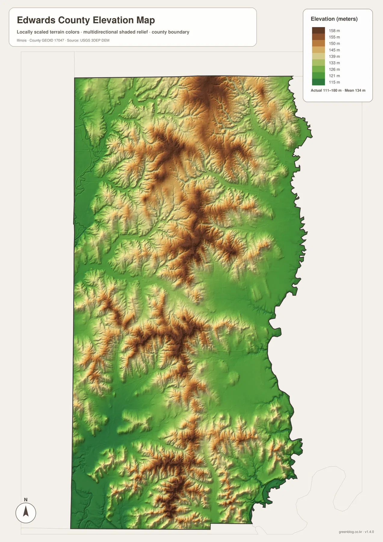
Comparing the elevation and water sheets makes the green corridors easier to identify. Little Wabash River, Bonpas Creek, and Walser Creek follow lower terrain, while the north-central ridges stand above their tributaries. Farther south, higher patches and low creek valleys alternate again. The county is therefore better understood as a set of short ridges separated by drainage corridors than as a completely flat surface.
111 to 180 meters is a countywide data range
A building site, road grade, drainage plan, or parcel needs point-specific elevation data or a professional survey. The 111–180 meter range is most useful for comparing Edwards County’s interior ridges with the Little Wabash and Bonpas lowlands, not for assigning an exact elevation to a town or address.
Use Albion as the fixed reference across roads, water, and relief
A practical way to use the files is to keep Albion fixed while changing the information layer. On the overview, follow Route 15 toward Browns and add West Salem, Bone Gap, and Grayville around the hub. The city-connections graphic then simplifies the spacing with straight-line distances from Albion.
Next, separate Little Wabash River on the west from Bonpas Creek on the east and locate Walser and Indian creeks between them. The elevation image completes the comparison by showing interior ridges above those drainage corridors. Using the same landmarks across all files keeps settlements, roads, waterways, and relief connected.
For real travel, current road information should take priority; present-day population should come from dated Census data, while river conditions and exact elevations need current agency or point-level sources. Within those limits, the Edwards County maps are useful for printed references, lessons, presentations, and advance geographic orientation.
Frequently Asked Questions
What is the county seat of Edwards County, Illinois?
Albion is the county seat. Illinois State Archives lists Palmyra as the seat from 1814 to 1821 and Albion from 1821 to the present. The current Edwards County Courthouse is also in Albion.
Is the 11-mile Albion-to-West Salem label driving distance?
No. The city-connections graphic labels about 11 miles to West Salem, 6 miles to Bone Gap, and 4 miles to Browns as direct distances from Albion. Actual road mileage can differ because the road network does not follow the straight connecting lines.
Does 111 to 180 meters give Albion’s elevation?
No. The elevation image identifies 111–180 m as the actual range across the Edwards County dataset and gives a mean of about 134 m. Exact elevation for Albion or any specific road, building, or property requires point-specific elevation or survey data.
Sources and Reference Material
The article uses the supplied Edwards County maps together with the official references below. For current roads, river stages, flood conditions, legal boundaries, or exact point elevations, use the latest information from the agency responsible for that subject.
- Illinois State Archives – Edwards County – 1814 establishment, county-seat history, and local government records
- Illinois Courts – Edwards County Courthouse – current courthouse location in Albion
- Edwards County Multi-Hazard Mitigation Plan – neighboring counties, major communities, and county background
- USGS National Hydrography – river, stream, reservoir, and lake reference data
- USGS 3D Elevation Program – elevation and terrain data
Map File Information
The ZIP file contains the high-resolution JPG originals for the Edwards County overview, city-connections map, terrain-and-water map, and elevation map. Each portrait image measures 2,572 × 3,638 pixels, keeping Albion-area road labels, creek names, lake labels, and relief colors easier to read when enlarged or printed.
- Included Files: 4 high-resolution JPG maps
- Printable Size: 2,572 × 3,638 pixels each
Related Maps
Green Map creates custom-edited map images using open geographic data sources such as geoBoundaries, Natural Earth, OpenStreetMap, and government open data.
These maps are edited visual materials, not raw data files, and are provided for education, documents, presentations, and graphic reference.