Boone County in northern Illinois is easiest to understand by starting at Belvidere and then looking north toward Poplar Grove, Timberlane, Candlewick Lake, Caledonia, and Capron. Belvidere occupies the southern half of the county and sits beside the broad Kishwaukee River corridor. The northern half has fewer large built-up areas but many more creek valleys and higher rolling ridges. That contrast between the lower south and higher north is one of the clearest patterns across the supplied maps.
This Boone County Illinois Map page brings together a county overview, a ranked-city distribution map, a terrain-and-water map, and an elevation map. You can download high-resolution JPG versions of all four maps together in one ZIP file for printing, classroom work, presentations, or closer viewing. The maps are designed for county-scale orientation and comparison, not for parcel boundaries, live traffic, flood decisions, navigation, or survey-grade elevation.
The Illinois State Archives records Boone County as established on March 4, 1837, with Belvidere as the county seat. On the supplied overview, the Boone County Courthouse is labeled inside Belvidere, reinforcing the city’s role as the main civic reference point. From that southern anchor, the maps make it easy to compare the central-northern towns, the Kishwaukee River and smaller creeks, and the rise toward higher ground in the northern part of the county.
Table of Contents
Roads fan out from Belvidere toward the northern towns
The county overview gives Belvidere the strongest visual weight. U.S. 20 crosses through the city from west to east, while I-90 runs just to the southwest. Route 76 heads north from the Belvidere area toward Poplar Grove and Timberlane before meeting Route 173. Route 173 then provides the main east-west reference across the central-northern county, passing the Caledonia area and continuing toward Capron.
Poplar Grove occupies a broad developed area north of Belvidere, with Timberlane and Candlewick Lake immediately to its west and northwest. Caledonia is farther west along Route 173, while Capron is near the eastern side of the county. Places outside the boundary—Cherry Valley, Loves Park, Argyle, Garden Prairie, and Chemung—appear around the edge and help place Boone County within the surrounding northern Illinois road network.
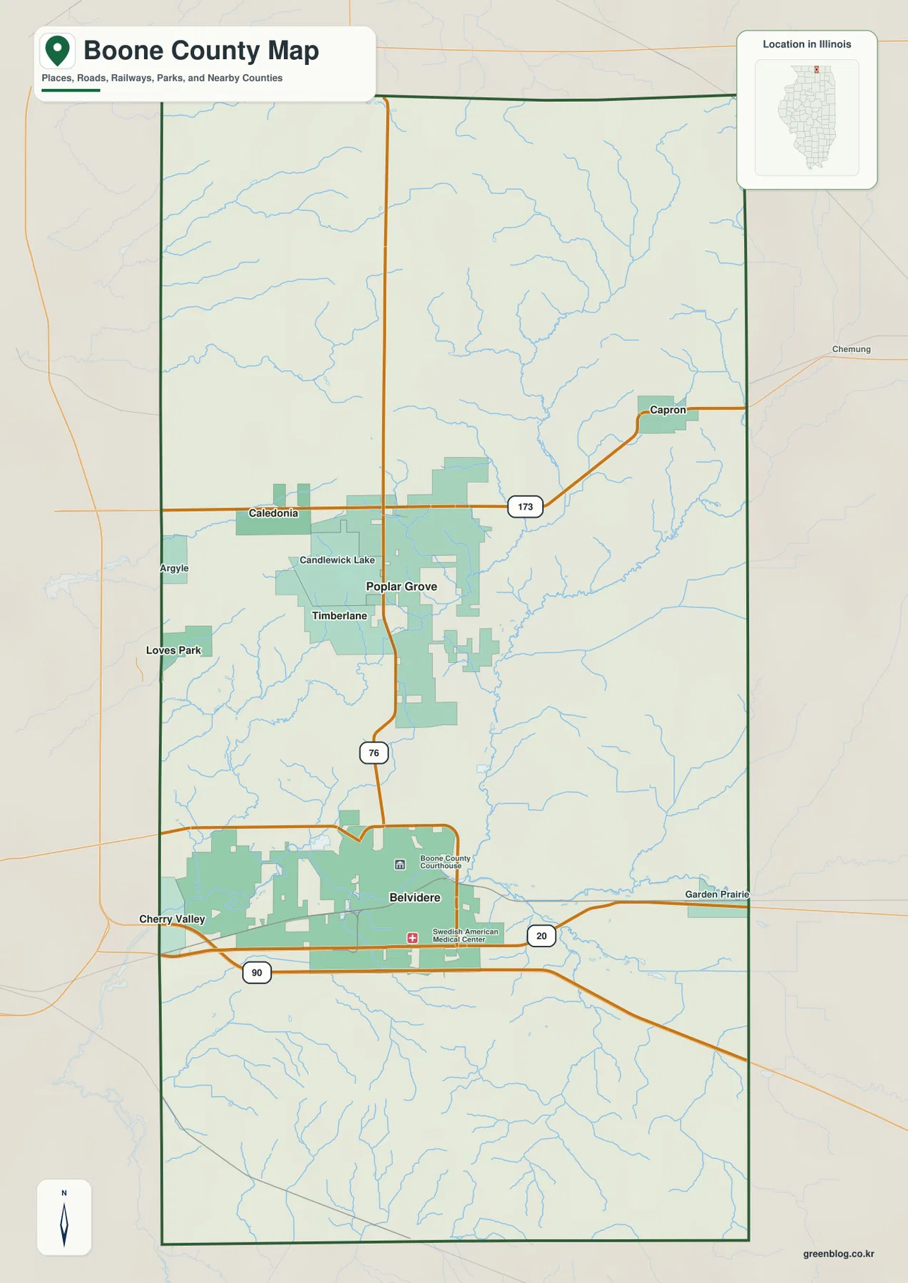
The blue stream network adds another layer that the road pattern alone does not show. Many small drainage lines branch across the northern half, while larger channels converge toward the Kishwaukee River system in the south. The result is a county that may look fairly open and rural on a road map but contains numerous shallow valleys and low corridors between the settled places.
What the overview is best used for
Use this map to see the direction from Belvidere to Poplar Grove or Capron and to compare U.S. 20, I-90, Route 76, and Route 173 across the county. It does not provide current road closures, construction notices, lane details, legal parcel lines, or private-access rights. Travel and property decisions should rely on current transportation and assessor information.
Five ranked places show a southern center and northern cluster
The city-distribution map removes most road detail and emphasizes five places. Belvidere is number 1, Poplar Grove number 2, Capron number 3, Timberlane number 4, and Caledonia number 5. The printed CITY INDEX lists values of 24,752 for Belvidere, 3,923 for Poplar Grove, 1,311 for Capron, 1,278 for Timberlane, and 226 for Caledonia.
The graphic does not display a census year or statistical date beside those values, so this article does not present them as current population counts. They are treated only as the figures printed on the supplied city map. The spatial pattern is clear without making a population claim: Belvidere is separated in the south, Poplar Grove and Timberlane form a close central-northern pair, and Capron and Caledonia sit near opposite sides of the county.
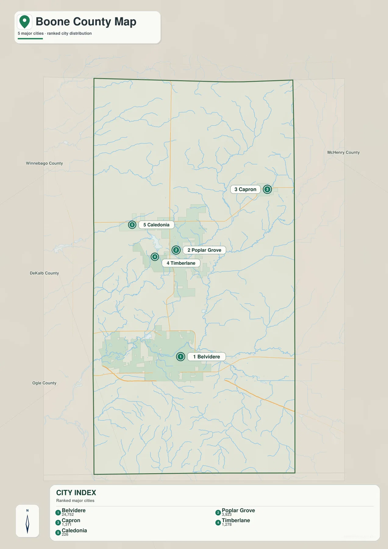
The simplified map is especially useful for seeing how widely the county’s main labeled places are spread. Belvidere is well south of the four other ranked locations. Poplar Grove and Timberlane are close together, while Capron sits near the eastern boundary and Caledonia near the western side. That arrangement provides a quick mental map before returning to the more detailed roads and streams.
Treat the CITY INDEX as map data, not a current census table
If a report requires current official population figures, use a dated U.S. Census Bureau source. The city map itself does not identify the year behind its index. On this page, the values are used only to describe the supplied ranking and the relative prominence of the five labeled places.
The Kishwaukee River connects a network of smaller creeks
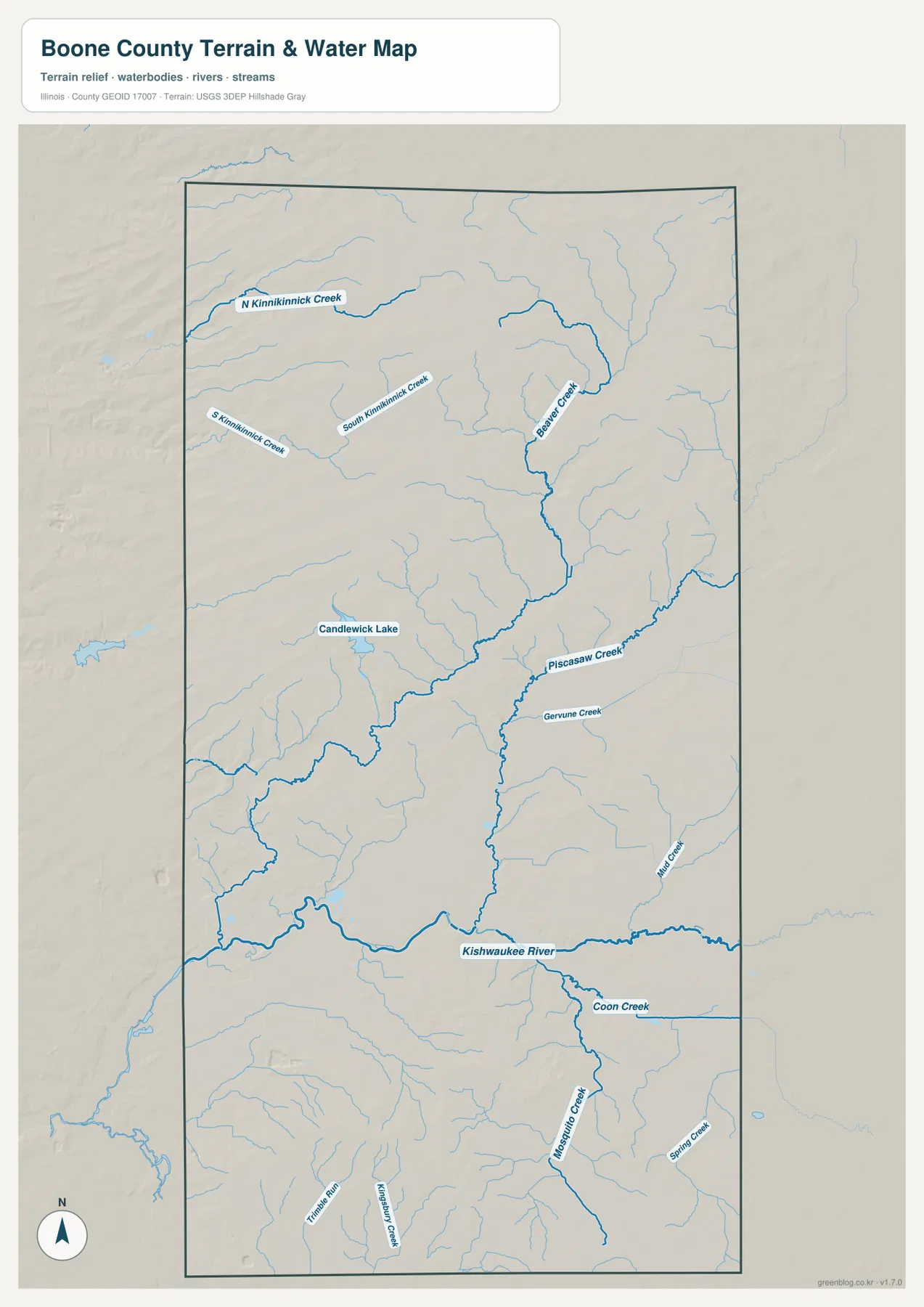
The terrain-and-water map shifts attention from roads to drainage. The Kishwaukee River is the dominant channel across the southern part of the county. Piscasaw Creek descends through the central area toward that river, while Coon Creek and Mosquito Creek are labeled farther southeast. In the north, North Kinnikinnick Creek and South Kinnikinnick Creek enter from the west, and Beaver Creek forms a long north-south feature in the northeastern half.
Candlewick Lake is the most obvious named lake in the central-western area. Smaller tributaries branch around it and across the rest of the county. The water pattern is therefore less about one huge lake than about a major southern river receiving water from many smaller creek systems. The shaded terrain also shows how those streams occupy lower corridors between gently rolling ridges.
Boone County Conservation District provides local examples of how important the Kishwaukee corridor is. Its Spencer Conservation Area lies along the western edge of Belvidere and is bordered on the south by the Kishwaukee River for nearly a mile and a half. Farther east, the East County Line Conservation Area in Garden Prairie occupies land within the Kishwaukee River floodplain and includes a canoe launch. These local sites match the map’s emphasis on the river as a major southern natural feature.
The water map is for location, not flood or navigation decisions
The map shows where rivers, creeks, a lake, and surrounding terrain are located. It does not provide flood-hazard zones, live water levels, depth, navigable channels, boating conditions, water rights, or legal access. Use current USGS and Boone County Conservation District information for safety, paddling, flood, or management decisions.
Elevation rises from the Kishwaukee lowlands to the north
The elevation map makes Boone County’s north-south contrast easy to see. Much of the southern half is green, representing lower terrain, and the lowest broad corridors align with the Kishwaukee River system and nearby tributary valleys. Moving north, the colors shift through yellow and orange to brown, with the highest rolling ground concentrated across the northern and northwestern parts of the county.
The map reports an actual countywide elevation range of about 207 to 320 meters and a mean of about 263 meters. Its color legend uses bands from roughly 228 to 300 meters, while the separate “Actual” line records the wider minimum and maximum in the mapped dataset. Those endpoints describe Boone County as a whole; they are not exact elevations for Belvidere, Capron, Candlewick Lake, or a specific property.
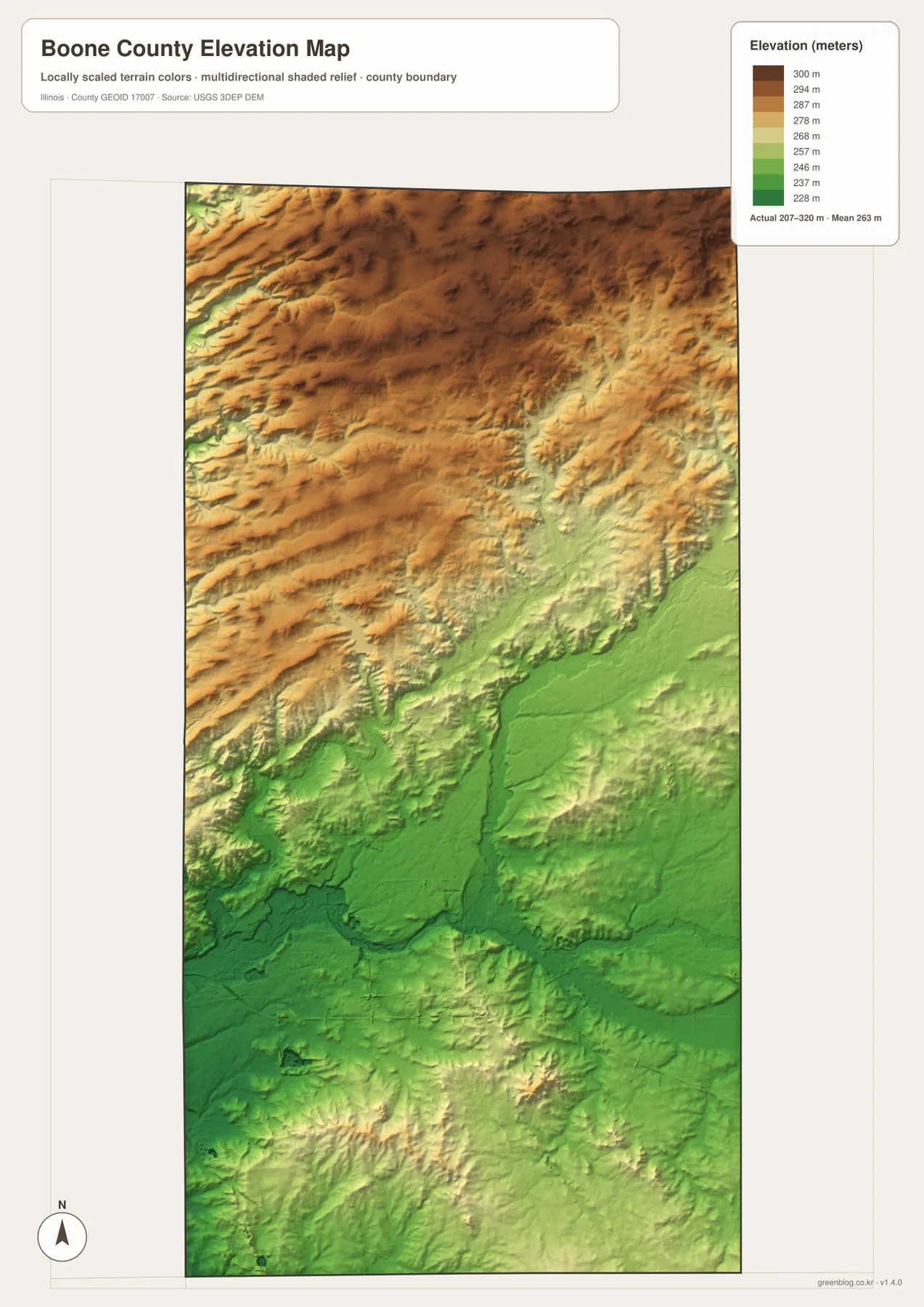
Comparing the elevation and water maps makes the relationship between valleys and streams clearer. The Kishwaukee River and central Piscasaw Creek occupy lower green corridors, while northern Kinnikinnick and Beaver creek branches cut through higher terrain. The map is useful for countywide comparison, but its colored surface is intentionally generalized and should not be substituted for a surveyed elevation at a specific site.
207 to 320 meters is a countywide range
An exact elevation for a building site, road grade, drainage project, or parcel requires point-specific source data or a professional survey. The map’s low and high endpoints summarize the countywide elevation dataset. They are most useful for understanding the broad transition from lower southern valleys to higher northern rolling ground.
A practical way to use the Boone County map set
Use the county overview when you need Belvidere, Poplar Grove, smaller towns, major roads, boundaries, and streams in one image. The ranked-city map is better for quickly comparing Belvidere, Poplar Grove, Capron, Timberlane, and Caledonia. Choose the terrain-and-water map for the Kishwaukee River, Kinnikinnick creeks, Beaver Creek, Piscasaw Creek, and Candlewick Lake. The elevation map is the clearest choice for comparing the lower southern valleys with higher ground to the north.
A useful sequence is to begin with Belvidere and U.S. 20 on the overview, then trace Route 76 north toward Poplar Grove and Route 173 toward Caledonia and Capron. Next, simplify the settlement pattern with the city map. Move to the water map to find the Kishwaukee River and Piscasaw Creek, and finish with elevation to see how those waterways occupy lower terrain below the northern ridges.
Each map has a defined purpose. The overview is not a parcel or live-traffic product, the CITY INDEX is not presented as a current census table, the water map does not assess flood or navigation conditions, and the elevation surface is not survey-grade. Within those limits, the set works well for printed reference sheets, teaching, presentations, county orientation, and trip-planning context.
Frequently Asked Questions
Where is Belvidere within Boone County?
On the supplied map, Belvidere is in the southern half of the county near U.S. 20 and the Kishwaukee River corridor. The Illinois State Archives identifies Belvidere as the Boone County seat. It is also a useful starting point for locating Poplar Grove, Capron, and the other northern communities.
Are the CITY INDEX values current population counts?
This page does not treat them as current population figures because the supplied map does not show a census year or statistical date beside the index. Use a dated U.S. Census Bureau source when an official current population figure is required.
Does 207 to 320 meters give Belvidere’s elevation?
No. The elevation map identifies 207–320 m as the actual range across the Boone County dataset and gives a mean of about 263 m. Exact elevation for Belvidere or any specific road, property, or structure requires point-specific elevation or survey data.
Sources and Reference Material
The article uses the supplied Boone County maps together with the official and county-specific references below. For current road conditions, water information, legal boundaries, or exact point elevations, use the responsible agency’s current source data rather than these explanatory county maps.
- Illinois State Archives – Boone County – county establishment, name origin, and county-seat information
- Boone County Conservation District – Spencer Conservation Area – Kishwaukee River and Belvidere-area natural context
- Boone County Conservation District – East County Line Conservation Area – Kishwaukee River floodplain context near Garden Prairie
- U.S. Census Bureau TIGER/Line Shapefiles – county boundaries and geographic reference data
- USGS 3D Elevation Program – elevation and terrain data
Map File Information
The high-resolution JPG originals for the Boone County overview, ranked-city map, terrain-and-water map, and elevation map are bundled in one ZIP file. Each image is 2,572 × 3,638 pixels, giving you more detail for zooming, printed reference sheets, classroom materials, and presentation graphics.
- Included Files: 4 high-resolution JPG maps
- Printable Size: 2,572 × 3,638 pixels each
Related Maps
Green Map creates custom-edited map images using open geographic data sources such as geoBoundaries, Natural Earth, OpenStreetMap, and government open data.
These maps are edited visual materials, not raw data files, and are provided for education, documents, presentations, and graphic reference.