Download the Custer County Idaho Map as one ZIP containing high-resolution A3 JPG versions of the county overview, city, terrain-and-water, and elevation maps. The WEBP previews below let you inspect Challis, Stanley, Mackay, Lost River, major roads, the Salmon River system, mountain lakes, and dramatic relief before opening the larger files for printing, classroom work, reports, or presentations.
Custer County occupies a large stretch of central Idaho high country. Challis sits along the Salmon River corridor, Stanley lies to the southwest among mountain lakes and steep valleys, and Mackay and Lost River occupy the southeastern Big Lost River side of the county. The official county site describes a landscape of valleys, rugged peaks, the Salmon River, and the Sawtooth National Recreation Area, all of which fit the strong contrasts visible across the supplied maps.
Table of Contents
Start at Challis, then follow the valleys toward Stanley and Lost River
The county overview places Challis near the north-central part of Custer County along the Salmon River corridor. The official county website and the Idaho Blue Book identify Challis as the county seat. On the map, it is also a practical transportation reference because Idaho 75 and US 93 meet in the area, connecting the northern valley with routes toward Stanley and the southeast.
Idaho 75 follows the mountain corridor toward Stanley in the southwest, while US 93 runs southeast from Challis toward Mackay and Lost River. Idaho 21 reaches Stanley from the west. The roads are shaped by the terrain: rather than crossing the county in straight lines, they bend through river valleys and lower mountain passes.
The county boundary is broad and irregular, with deep bends in the west and northwest and a long southeastern reach that narrows near the Lost River side. Valley, Lemhi, Butte, and Blaine counties are among the neighboring areas shown on the map. Learning this outline first makes it easier to place the Salmon River, the Big Lost River valley, and the mountain-lake country around Stanley.
The city map compares Challis, Mackay, Stanley, and Lost River
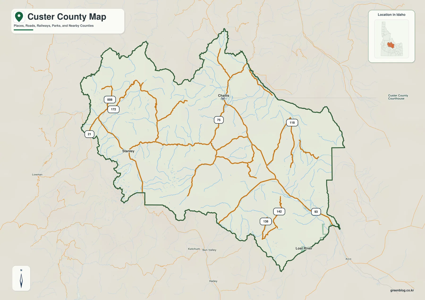
The city-connections map uses Challis as the hub and labels Mackay, Stanley, and Lost River as the other major reference points. The supplied index ranks Challis first, Mackay second, Stanley third, and Lost River fourth. Because the county has relatively few large settlements, this simplified view is especially useful for understanding direction before adding roads and terrain.
The connector labels are straight-line distances, not driving distances. Stanley is shown about 41 miles from Challis, Mackay about 51 miles away, and Lost River about 64 miles away. Mountain passes and winding roads can make the actual road trip substantially longer, so the labels are best used for relative spacing rather than travel-time estimates.
Stanley lies southwest of Challis in the mountain-lake country, while Mackay and Lost River are southeast along the Big Lost River side. After locating those points on the city map, the county overview makes the road relationships clear: Idaho 75 leads toward Stanley and US 93 follows the southeastern corridor toward Mackay and Lost River.
Salmon River headwaters, Sawtooth lakes, and the Big Lost River system
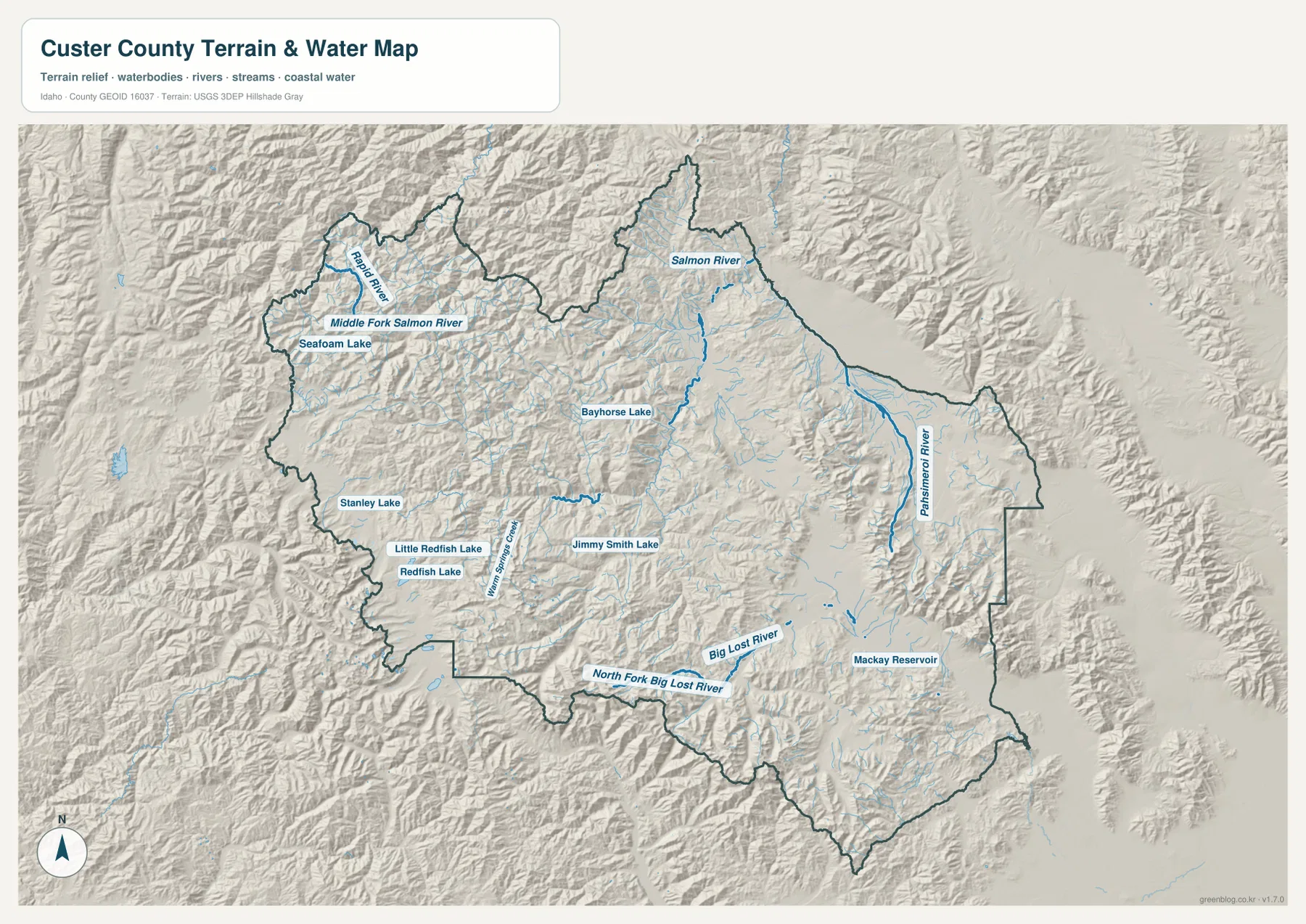
The terrain-and-water map is dominated in the north by the Salmon River and its mountain tributaries. The Middle Fork Salmon River and Rapid River are labeled in the northwestern high country, with Seafoam Lake nearby. These drainages cut through deeply folded terrain and help explain why the northern part of the county contains long river valleys separated by steep ridges.
Around Stanley, the map labels Stanley Lake, Redfish Lake, Little Redfish Lake, and Warm Springs Creek. The shaded terrain makes the setting particularly clear: the lakes occupy narrow mountain basins and valleys rather than broad lowland plains. Bayhorse Lake and Jimmy Smith Lake provide additional landmarks closer to the center of the county.
The southeastern drainage is different. Big Lost River and North Fork Big Lost River cross the lower valleys, and Mackay Reservoir forms a major water landmark. Pahsimeroi River is labeled farther east in a separate north-south valley. With the Salmon River system, Sawtooth-area lakes, and Big Lost River drainage all inside one county, the water map shows several distinct mountain watersheds rather than one simple river network. It is a geographic reference map, not a flood-hazard map, depth chart, navigation product, parcel map, or legal water-right document.
Deep river valleys sit below some of Idaho’s highest mountain terrain
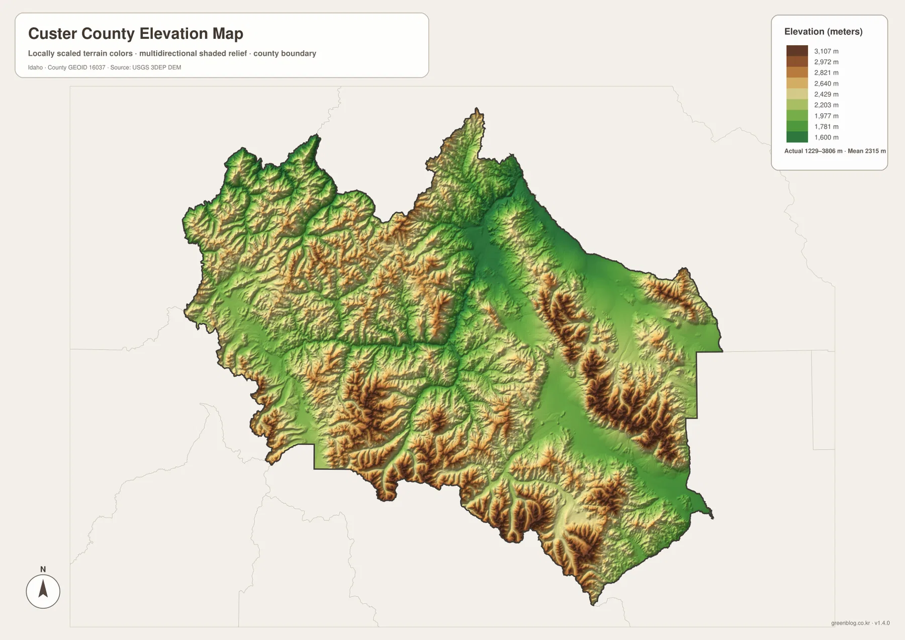
The elevation map makes the county’s rugged character immediately clear. Lower green corridors follow the Salmon River and the southeastern Big Lost River valley, while yellow, tan, and brown highlands spread across much of the west, south, center, and east. The same valleys that carry roads and settlements on the other maps appear as lower bands between large mountain blocks.
The supplied elevation graphic reports an actual range of about 1,229 to 3,806 meters, with a mean near 2,315 meters. Custer County’s official website also notes that the county contains Mount Borah, the highest mountain in Idaho. Even without labeling every summit, the elevation map shows how much of the county is high terrain and how sharply many ridges rise above the inhabited valleys.
The colors are intended for county-scale comparison rather than site-specific measurement. They are useful for seeing why Challis, Stanley, Mackay, and other places occupy valleys and lower corridors, and why streams descend from so many high ridges. A property survey, road project, or engineering study would require a more precise elevation source for an individual site.
Use the maps together to connect towns, roads, water, and relief
For ordinary orientation, start with the city map to locate Challis, Stanley, Mackay, and Lost River, then switch to the county overview to add Idaho 75, US 93, Idaho 21, and the full boundary. This sequence is easier than beginning with the dense mountain terrain because the main settlement directions are already familiar.
The terrain-and-water map is the next step when the Salmon River, Redfish Lake, Mackay Reservoir, or the Big Lost River system is the main interest. After finding those features, the elevation map explains why the roads follow specific valleys and why settlements are separated by large stretches of high country.
This combination works well for classrooms, local research, trip planning, reports, and presentations. A reader can trace Challis from the city map to the road network, follow the Salmon River on the water map, and then compare the lower valley with the surrounding mountains on the elevation map. The same method works for Stanley or the Mackay–Lost River corridor.
Frequently Asked Questions
Where is Challis on the Custer County map?
Challis is in the north-central part of the county near the Salmon River corridor, where Idaho 75 and US 93 meet. It is the county seat and the easiest reference point for locating Stanley, Mackay, and Lost River.
Where are Redfish Lake and Stanley Lake?
Both are in the mountainous southwestern part of the county around Stanley. Little Redfish Lake is also labeled nearby, and the terrain-and-water map shows how the lakes fit among steep ridges and tributary valleys.
Which parts of Custer County are highest?
Large mountain areas across the west, southwest, center, and east are much higher than the river valleys. The supplied elevation map reports an overall range of roughly 1,229 to 3,806 meters.
Map File Information
The ZIP contains high-resolution A3 JPG versions of the Custer County overview, city, terrain-and-water, and elevation maps.
- File Type: JPG files inside one ZIP archive
Related Maps
Sources and references
- Custer County, Idaho official website
- Idaho Secretary of State — Idaho Blue Book, Custer County
- U.S. Census Bureau TIGER/Line Shapefiles
- USGS National Hydrography
- USGS 3D Elevation Program
Green Map creates custom-edited map images using open geographic data sources such as geoBoundaries, Natural Earth, OpenStreetMap, and government open data.
These maps are edited visual materials, not raw data files, and are provided for education, documents, presentations, and graphic reference.