Download the Clark County Idaho Map as one ZIP containing high-resolution A3 JPG versions of the county overview, city, terrain-and-water, and elevation maps. The WEBP previews below make it easy to check Dubois, Spencer, Interstate 15, Camas Creek, mountain tributaries, reservoirs, and relief before opening the larger files for printing, classroom work, reports, or presentations.
Clark County in northeastern Idaho is a large, sparsely settled county where a broad lower interior is surrounded by much higher mountain terrain. Dubois sits in the south-central part of the county, Spencer lies farther north, and smaller labels such as Kilgore and Lone Pine help define the county’s wide east-west reach. The Camas Creek drainage is prominent in the northeast and east, while Medicine Lodge Creek, Birch Creek, and other streams cut through the western mountains.
Table of Contents
Start with Dubois to understand the county’s long shape
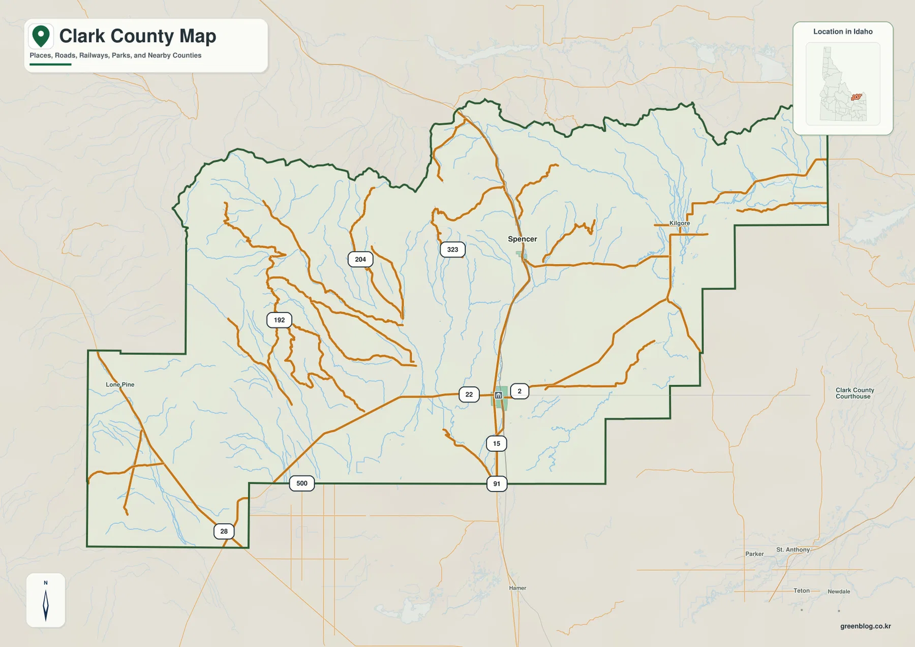
The county overview makes Dubois the easiest reference point. It sits near Interstate 15 and Route 22, and Clark County’s official planning material identifies Dubois as the county seat. From Dubois, Interstate 15 continues north toward Spencer. Kilgore is labeled farther east, while Lone Pine appears near the western edge, giving the map several widely separated landmarks.
Route 22 crosses the Dubois area from west to east, and Route 28 appears near the southwestern part of the county. Several smaller numbered local roads branch into the interior and northern valleys. The road pattern becomes sparser away from the central low country, especially toward the rugged northwestern and western mountain blocks.
The county boundary is highly irregular, with multiple steps along the north and east and a separate southwestern extension. Lemhi, Butte, Jefferson, and Fremont counties are labeled around the map. Learning this outline first makes it much easier to understand where the city and water features sit when the more specialized views are opened.
The city map reduces the county to Dubois and Spencer
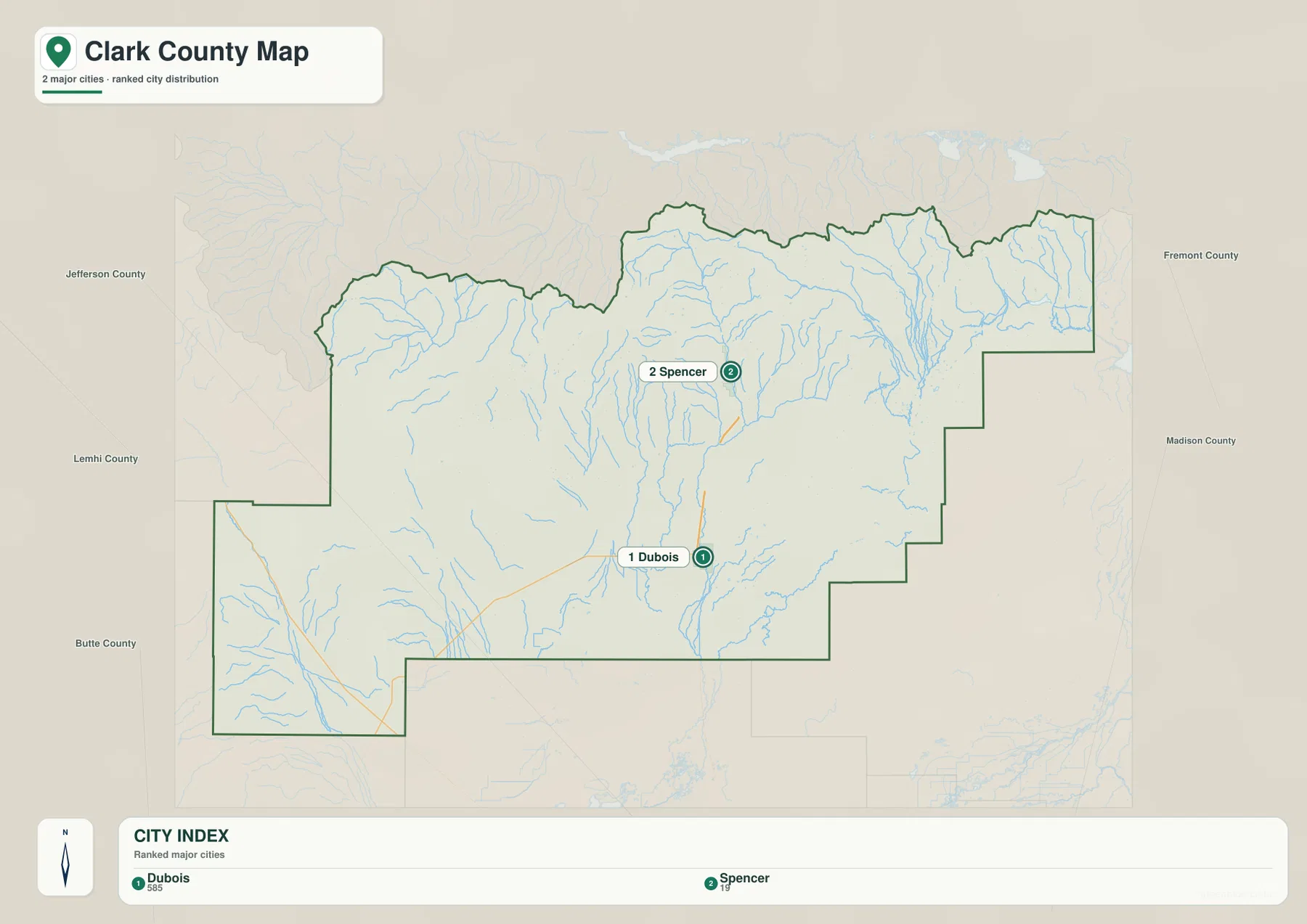
The city map highlights only two major communities: Dubois and Spencer. Dubois is ranked first in the supplied city index and Spencer second. With so few labels, the map makes the north-south relationship easy to see and reinforces the role of Dubois as the main settlement reference point.
Returning to the county overview after using the city map adds the transportation context. Interstate 15 connects the Dubois and Spencer corridor, while Kilgore and Lone Pine show that the county extends far beyond those two incorporated places. The surrounding county names also help readers place the two cities within the broader northeastern Idaho setting.
The city map does not provide connector-distance labels, so it should not be used to infer a precise driving distance between the communities. Its strength is simplicity: it quickly shows which direction Spencer lies from Dubois and leaves the detailed roads, streams, and relief to the other maps.
Camas Creek and mountain tributaries organize the water map
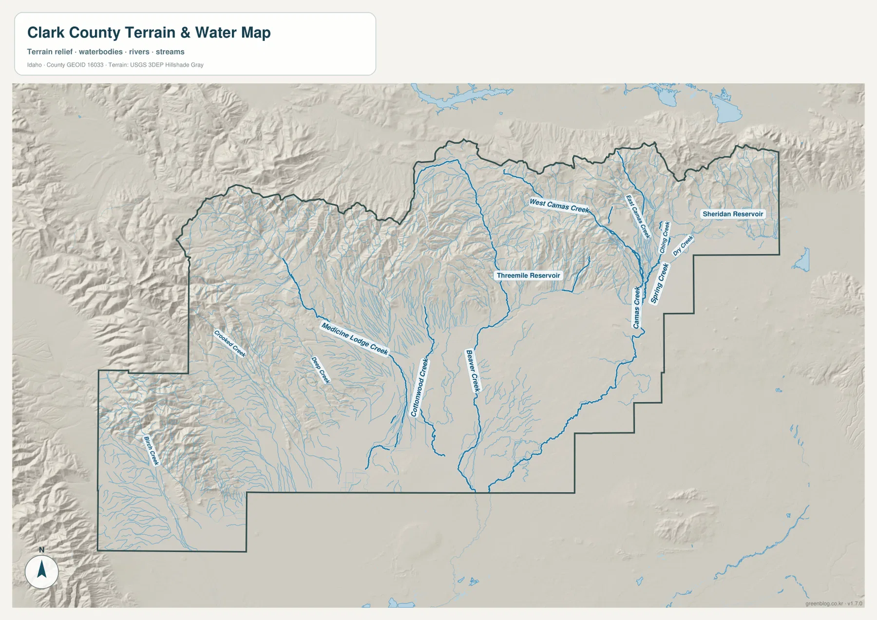
The terrain-and-water map gives the northeastern part of Clark County a clear drainage structure. West Camas Creek and East Camas Creek descend from the northern mountains, and Camas Creek continues through the eastern low country. Spring Creek and Dry Creek appear nearby, adding smaller branches around the same drainage area.
Farther west, Medicine Lodge Creek crosses mountain-and-valley terrain and Crooked Creek appears near the western side. Cottonwood Creek and Beaver Creek run through the central area, while Birch Creek occupies the separate southwestern extension of the county. These streams show how many narrow mountain valleys feed into the broader interior.
Threemile Reservoir is labeled in the north-central part of the county, and Sheridan Reservoir appears near the eastern edge. Both are useful landmarks when comparing the water map with the relief underneath it. This map is intended as a geographic reference for streams and reservoirs; it is not a flood-hazard map, depth chart, navigation product, parcel map, or legal water-right document.
A lower interior is ringed by high northern and western mountains
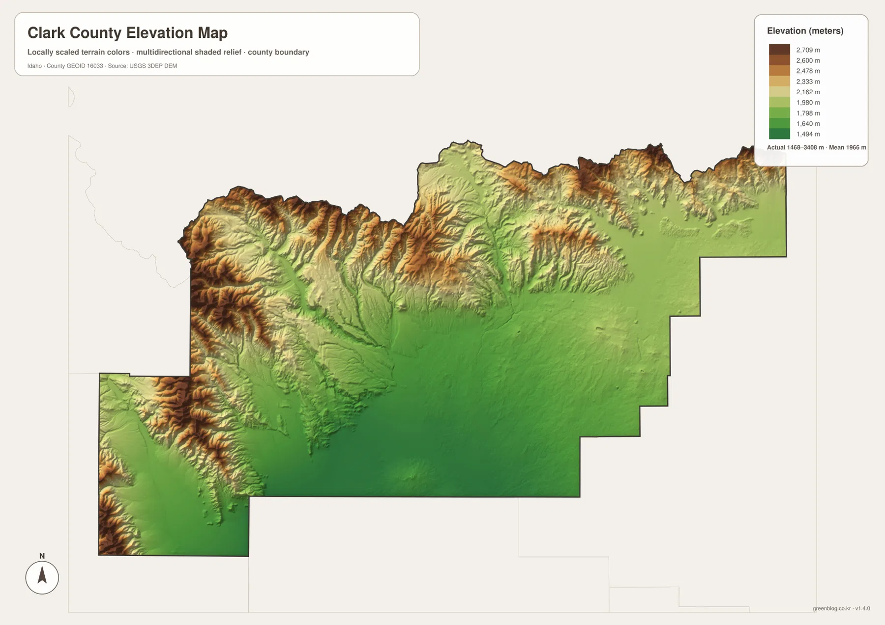
The elevation map makes the county’s relief easy to understand. Broad green areas cover much of the central and southeastern interior, marking the lower and gentler ground. Yellow, tan, and brown colors rise sharply along the northern boundary and across the western mountains, with some of the strongest relief in the northwest and north-central high country.
The supplied elevation graphic reports an actual range of about 1,468 to 3,408 meters, with a mean near 1,966 meters. Dubois and Spencer sit within the lower interior rather than on the highest ridges. The Camas Creek area in the east is also relatively low compared with the mountain rim, while the valleys of Medicine Lodge Creek and Birch Creek cut through much higher western terrain.
The colors are useful for county-scale comparison rather than property-level measurement. They show where roads and settlements occupy gentler land, where streams emerge from high country, and how sharply the western and northern edges rise. A survey or engineering project would require a more precise elevation source for an individual site.
Using the maps together connects roads, water, and relief
For ordinary orientation, begin with the city map to locate Dubois and Spencer, then switch to the county overview to add Interstate 15, Route 22, Route 28, Kilgore, Lone Pine, and the irregular county boundary. That sequence is especially useful for readers who want a quick sense of direction before looking at the more detailed terrain.
The terrain-and-water map is the next step when Camas Creek, Medicine Lodge Creek, Birch Creek, or the reservoirs are the main interest. After locating those features, the elevation map explains why the stream network is so dense along the mountain edges and why the central interior appears much more open.
This combination works well for classrooms, local research, trip planning, reports, and presentations. A student can trace Dubois from the city map to Interstate 15 on the overview, then compare nearby drainage on the water map and the surrounding lower terrain on the elevation map. The same method can be used for Spencer, the Camas Creek drainage, or the western mountain valleys.
Frequently Asked Questions
Where is Dubois on the Clark County map?
Dubois is in the south-central part of the county near Interstate 15 and Route 22. It is the county seat and the easiest reference point for locating Spencer to the north, Kilgore to the east, and Lone Pine to the west.
Where can I find Camas Creek?
The terrain-and-water map shows the Camas Creek drainage across the northeastern and eastern part of the county. West Camas Creek and East Camas Creek descend from the north, and smaller streams such as Spring Creek and Dry Creek are labeled nearby.
Which parts of Clark County are highest?
The northern boundary and the western mountain areas are the highest parts of the supplied elevation map. The broad central and southeastern interior is lower, and the graphic reports an overall elevation range of roughly 1,468 to 3,408 meters.
Map File Information
The ZIP contains high-resolution A3 JPG versions of the Clark County overview, city, terrain-and-water, and elevation maps.
- File Type: JPG files inside one ZIP archive
Related Maps
Sources and references
- Clark County official website
- Clark County All Hazard Mitigation Plan
- U.S. Census Bureau TIGER/Line Shapefiles
- USGS National Hydrography
- USGS 3D Elevation Program
Green Map creates custom-edited map images using open geographic data sources such as geoBoundaries, Natural Earth, OpenStreetMap, and government open data.
These maps are edited visual materials, not raw data files, and are provided for education, documents, presentations, and graphic reference.