Download the high-resolution Deuel County South Dakota Map JPG files from the ZIP on this page. Clear Lake is the easiest place to begin, sitting near the center of the county where SD 15 and SD 22 meet. US 212 runs across the northern edge, while Goodwin and Altamont provide northern references and Brandt, Toronto, and Astoria help define the southern half. The map package also shows lakes spread from the northwest to the southeast, a dense stream network on the east, and an elevation range of 348 to 621 meters.
Deuel County becomes much easier to understand when Clear Lake is used as a cross-map anchor. The western half is generally higher, while the terrain descends toward the eastern side where the West Branch Lac Qui Parle River, Cobb Creek, Lost Creek, and other channels become more prominent. Lakes such as Lake Alice and Lake Cochrane add separate water landmarks, so the county is not defined by a single river or one lake cluster.
Table of Contents
Clear Lake anchors the SD 15 and SD 22 road network
The general county map places Clear Lake slightly south of the county’s midpoint. SD 15 runs north-south through the same area, while SD 22 crosses east-west. The City of Clear Lake website also describes the community as being at the intersection of these two highways, making the road pattern on the map easy to confirm. US 212 provides another strong east-west line near the northern boundary.
Goodwin is shown in the northwest, and Altamont lies farther east in the upper half of the county. South of Clear Lake, Brandt appears before the map reaches Toronto and Astoria near the bottom. Route markers 28 and 11 help define the southern and eastern edges, while several numbered local roads fill the rural interior. The map is useful for location reference rather than live navigation, so current road conditions should be checked separately.
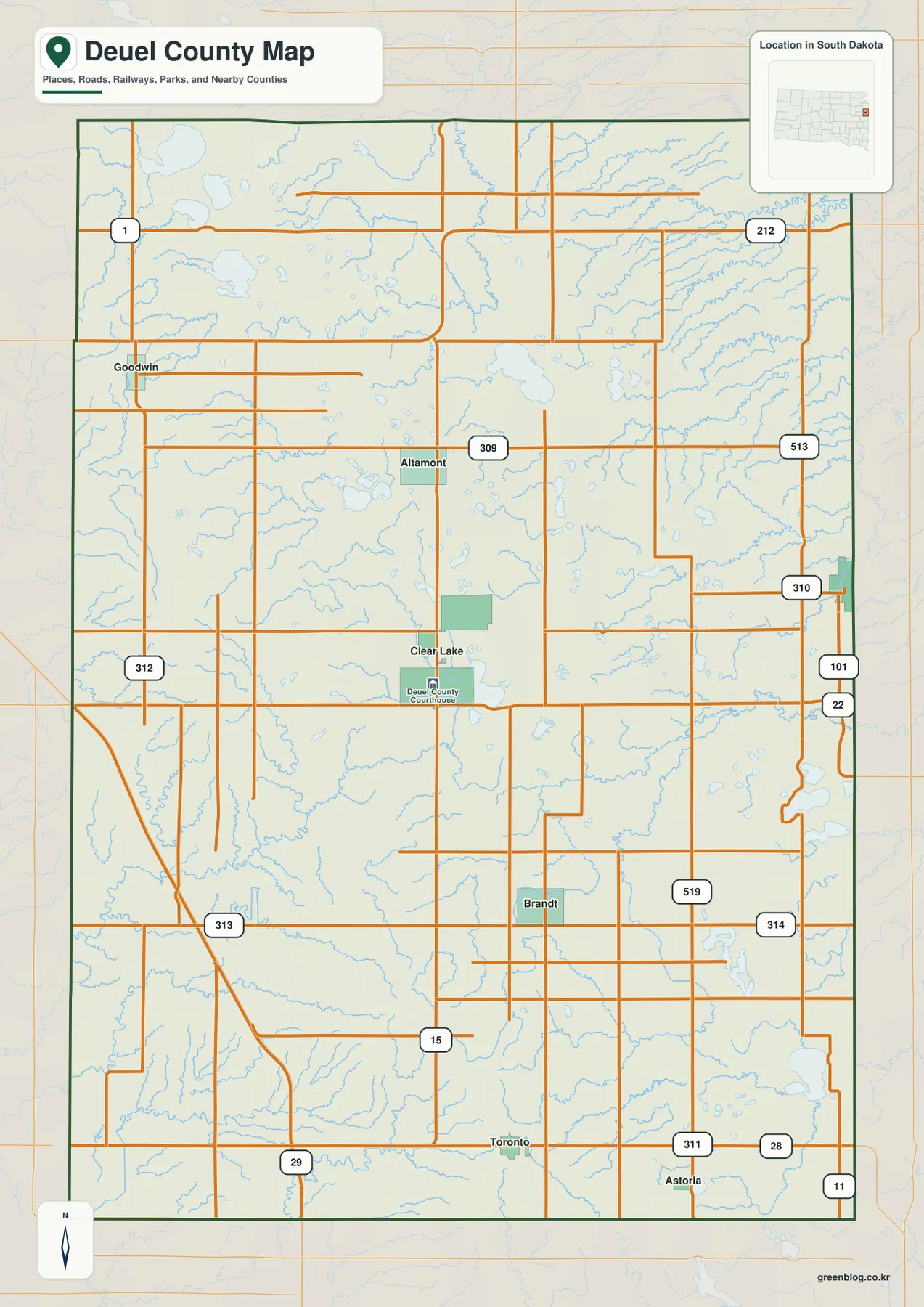
Deuel County’s official website lists the courthouse in Clear Lake, while the city website identifies Clear Lake as the county seat. That administrative role matches the map, where the city sits close to the middle of the county and is surrounded by one of the clearest road junctions. Starting here makes the later city, water, and elevation views easier to follow.
Six ranked communities spread from Goodwin to Gary and Astoria
The city-index view includes Clear Lake, Gary, Toronto, Astoria, Goodwin, and Brandt. It is not a distance diagram. Instead, the useful information is how widely the places are distributed: Clear Lake is central, Gary is near the eastern boundary, Toronto and Astoria are in the south, Goodwin is northwest, and Brandt sits between Clear Lake and the southern towns.
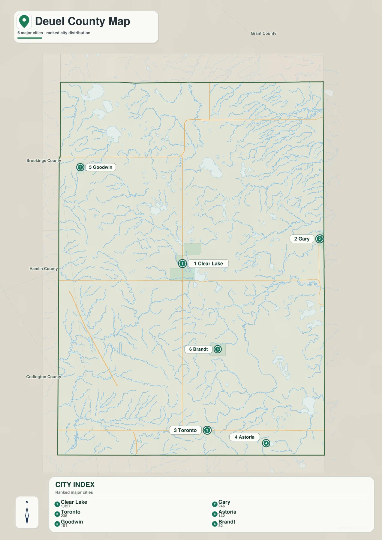
The printed CITY INDEX lists Clear Lake 1,327, Gary 246, Toronto 238, Astoria 142, Goodwin 101, and Brandt 82. This article treats those figures only as values printed on the supplied image, not as current population estimates. Anyone who needs present-day population should verify it with the U.S. Census Bureau.
The image also labels neighboring counties on the South Dakota side, including Grant, Brookings, Hamlin, and Codington. These names help place Deuel County within the surrounding region, but exact legal boundaries should be checked against authoritative boundary data when needed.
Lakes are scattered across the county while the eastern streams feed the Lac Qui Parle system
The terrain-and-water view shows Round Lake and Bullhead Lake in the northwest, with Wigdale Lake farther south. Lake Alice occupies a separate position in the upper-middle eastern part of the county. In the southeast, Lake Cochrane, Fox Lake, and Fish Lake provide a chain of distinct water landmarks rather than one continuous lake system.
The strongest stream reference on the east is the West Branch Lac Qui Parle River. It bends through the eastern half and is joined by smaller channels such as the North Branch and Cobb Creek. Lost Creek and Crow Timber Creek are clearly labeled in the northeast, where the stream network is much denser than in the broad western uplands.
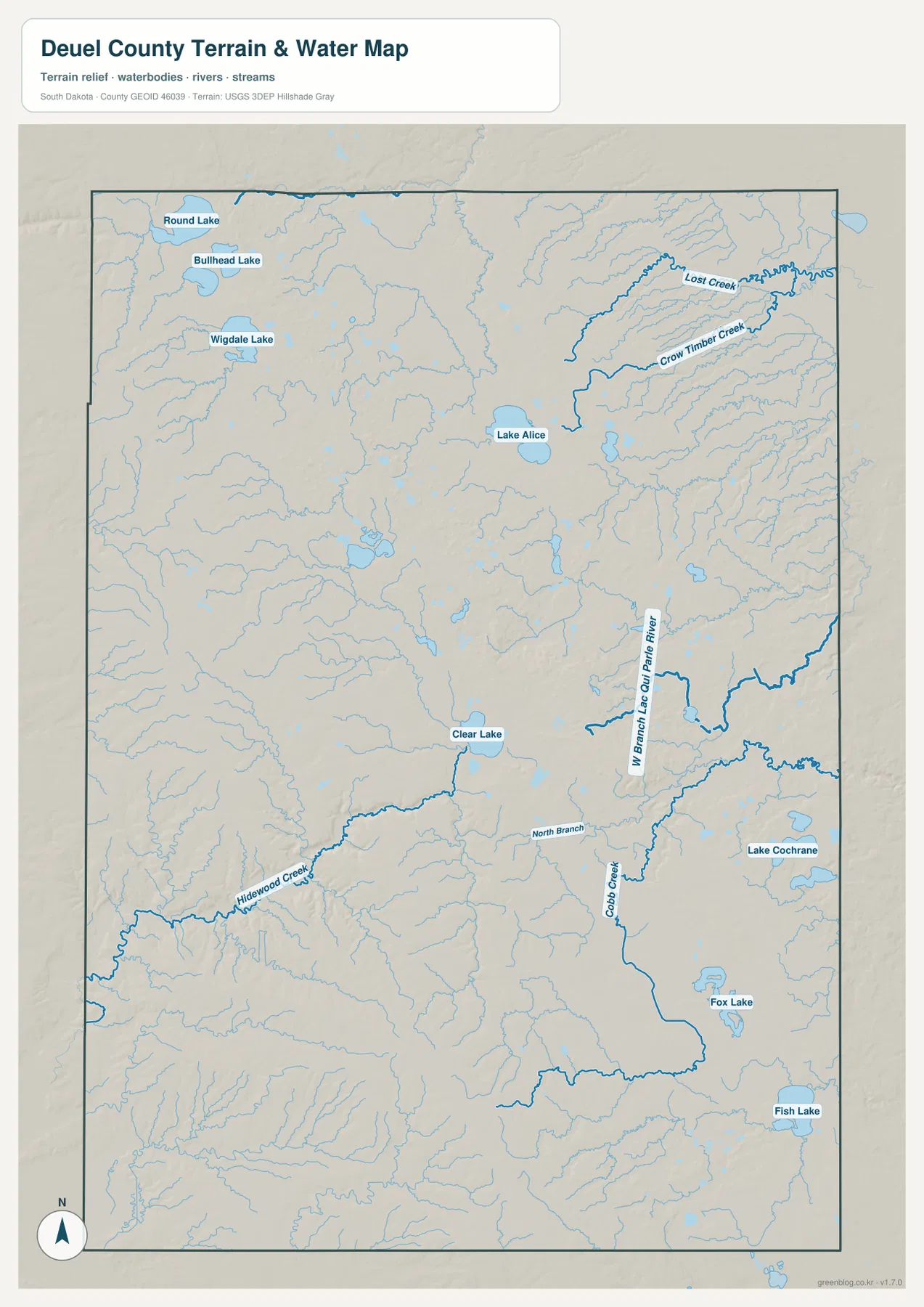
Hidewood Creek is a useful central-western reference because it runs toward the Clear Lake area from the west. Comparing it with the elevation view shows how streams occupy lower cuts through otherwise higher terrain. The static water image is designed for location and name reference, not current lake level, streamflow, flood risk, water quality, or recreation conditions.
For current field conditions around Lake Cochrane, the Lac Qui Parle River system, or other water bodies, use up-to-date USGS or local information. The map here is best used to connect water features with the communities and roads shown elsewhere on the page.
Elevation falls from the western uplands toward the eastern lowlands
The elevation map reports an actual Deuel County range of 348 to 621 meters and a mean of 540 meters. Brown and dark-brown terrain dominates the west and northwest, marking the highest broad areas. Moving east, the colors shift through orange and yellow before large green zones appear along the eastern and northeastern side.
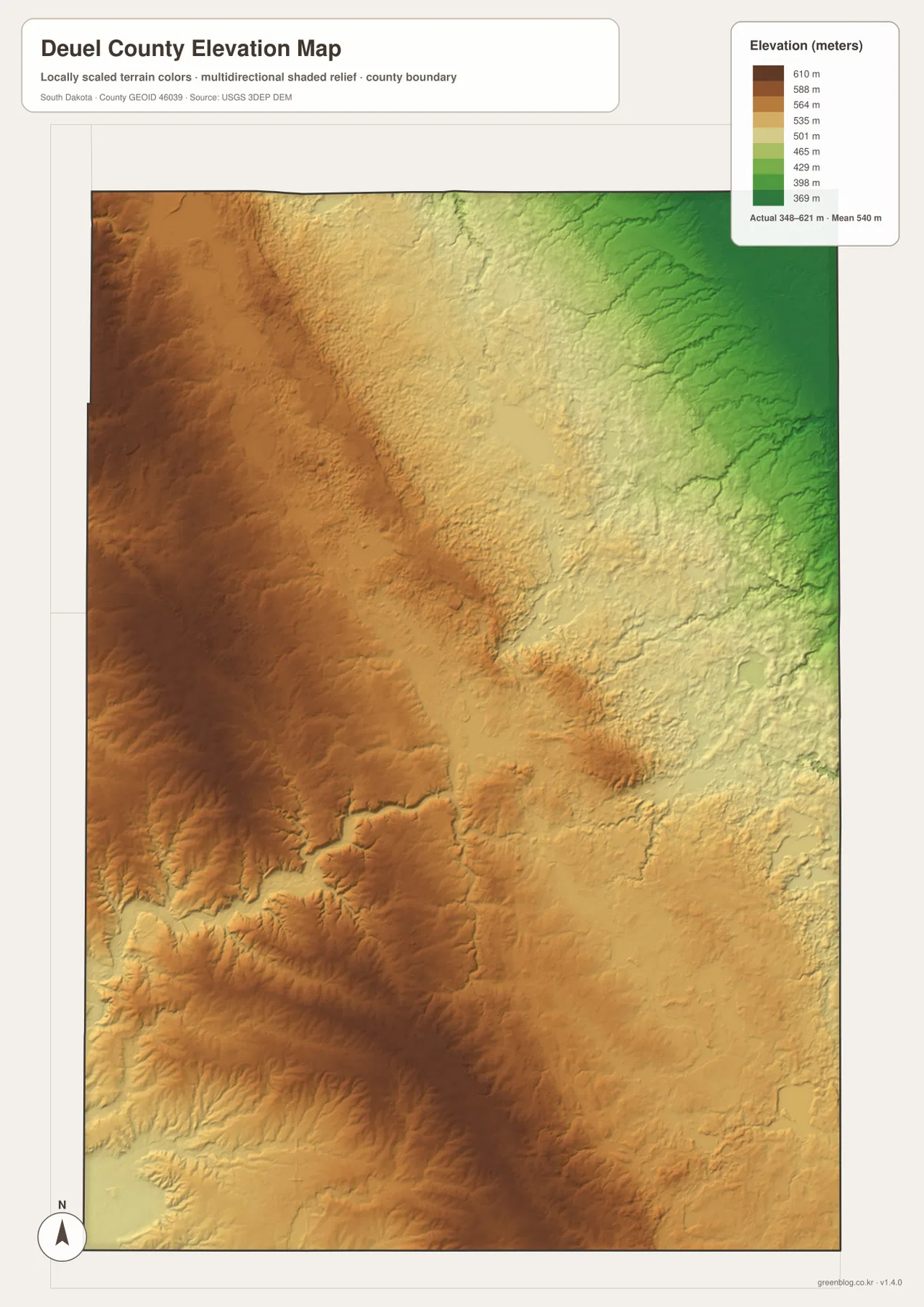
The drop is strong but not perfectly uniform. A broad elevated belt remains through parts of the center and south-central county, while creeks carve lower channels into the western terrain. The eastern side also contains smaller ridges, so the surface cannot be reduced to one simple slope.
The water and elevation views line up particularly well around the eastern streams. The West Branch Lac Qui Parle River, Cobb Creek, Lost Creek, and Crow Timber Creek occupy terrain that is generally lower than the western uplands. The 348–621 meter range is suitable for county-scale comparison, not parcel, building, or engineering measurement. A location-specific elevation should be checked with detailed USGS 3DEP data or professional survey information.
Follow Clear Lake across the maps to connect roads, towns, water, and relief
Clear Lake works well as a single anchor across all four views. The road map ties it to SD 15 and SD 22. The city index places Gary to the east, Goodwin to the northwest, and Toronto and Astoria to the south. The water view adds Hidewood Creek near the central area and the Lac Qui Parle stream system farther east. The elevation surface then places Clear Lake between the higher western country and the lower eastern side.
Other communities create useful regional comparisons. Gary is close to the eastern lowlands and stream network, while Goodwin sits nearer the higher northwest. Toronto and Astoria help define the southern edge, and Brandt provides a midpoint between Clear Lake and the southern communities. Following one place through roads, water, and elevation is more useful than memorizing separate feature lists.
The ZIP below contains the general county, city, terrain-and-water, and elevation maps as original high-resolution JPG files. Each image is 2572 × 3638 pixels in an A3-friendly format, suitable for printing, classroom handouts, presentations, or close viewing. Legal boundaries, live road conditions, current water information, flood decisions, and survey-grade elevation require current authoritative data in addition to these reference maps.
Frequently Asked Questions
Which main highways are shown around Clear Lake?
The supplied county map shows SD 15 running north-south through Clear Lake and SD 22 crossing east-west. The City of Clear Lake website also identifies the community at the intersection of these two highways. US 212 is visible farther north near the county’s upper edge.
Can Lake Cochrane and the Lac Qui Parle River system be seen on the same water map?
Yes. Lake Cochrane is shown in the southeastern part of the county, while the West Branch Lac Qui Parle River runs through the eastern half. Cobb Creek, Lost Creek, Crow Timber Creek, and several additional lakes are also labeled.
Can the 348–621 meter range be used as the exact elevation of a property?
No. The range is useful for broad county-scale comparison. A property-specific or engineering elevation should be checked with detailed USGS 3DEP data or professional survey information.
Map File Information
The Deuel County general, city, terrain-and-water, and elevation views are packaged as high-resolution JPG files.
- Included Files: Use only the versions confirmed in the article and supplied images
- File Type: Use the confirmed download contents
- Intended Use: Printing, education, presentations, and map-based projects
Related Maps
Sources and References
The article is based first on the names, roads, water features, and elevation values visible in the supplied Deuel County maps. These official sources provide additional county, city, boundary, hydrography, and elevation reference information.
- Deuel County official website
- City of Clear Lake official website
- U.S. Census Bureau TIGER/Line Shapefiles
- USGS National Hydrography
- USGS 3D Elevation Program
Green Map creates custom-edited map images using open geographic data sources such as geoBoundaries, Natural Earth, OpenStreetMap, and government open data.
These maps are edited visual materials, not raw data files, and are provided for education, documents, presentations, and graphic reference.