Murray County has one of the clearest east-west land-cover contrasts in this Georgia map series. Forest accounts for 64.47% of the supplied 2025 classification, while agriculture covers 18.82% and developed land 11.01%. The eastern half is overwhelmingly wooded, while farms, towns, and road-oriented development are concentrated farther west around Chatsworth and Eton. This Murray County Georgia Land Cover Map makes that divide easy to see.
Four WebP previews cover current land cover, vegetation, fractional impervious surface, and the 1985–2025 endpoint comparison. The original 2480 × 1754 JPG maps are bundled in one ZIP for reports, classroom work, county profiles, and presentations.
Table of Contents
The wooded eastern half is the feature that sets Murray County apart
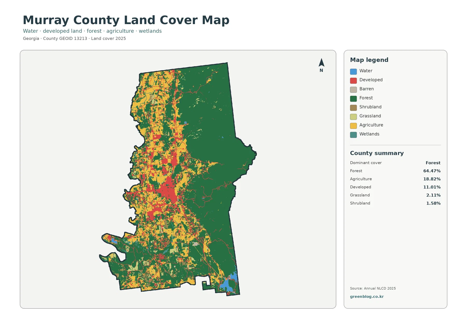
Dark green covers most of the eastern half with very few large interruptions. The western side is different: yellow farm blocks, red development, lighter open cover, and smaller forest patches appear in a much denser mixture. Forest still occurs west of the county center, but it no longer forms the nearly continuous surface seen toward the mountains.
The Forest Service describes the Cohutta Mountains northeast of Chatsworth as part of the Conasauga Ranger District of the Chattahoochee National Forest. That official geography helps explain the broad eastern forest pattern. It does not mean every green pixel belongs to federal land. Annual NLCD classifies surface cover, not ownership or wilderness boundaries.
Agriculture covers 18.82% and is concentrated primarily in the western and northwestern portions, with additional farm openings farther south. Grassland accounts for 2.11% and shrubland 1.58%. Together those classes create a much more varied western landscape than the forest-heavy mountain side.
The vegetation map shows where farming replaces the continuous mountain forest
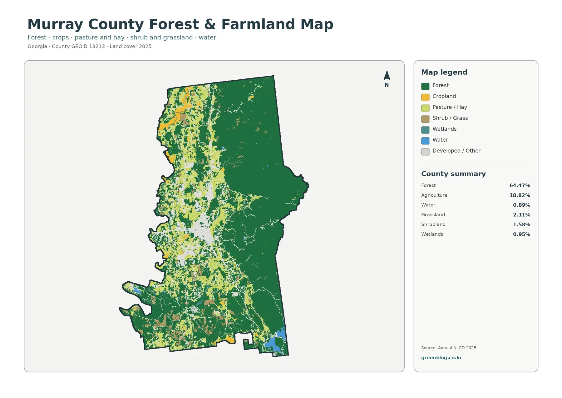
With the developed class muted, the western farm pattern is easier to separate from the eastern mountains. Broad yellow blocks appear from the northwest toward the county’s central corridor, while smaller fields and pasture-like openings continue south. The forest boundary is irregular rather than straight, with wooded ridges and farm openings meeting repeatedly through the middle of the county.
Murray County Extension provides Agriculture and Natural Resources programs along with soil, water, forage, and hay testing. That local service context confirms that farming and land management are active county concerns. The raster cannot identify which crop occupies a yellow cell or whether a light-green area is a particular pasture, so commodity-level interpretation requires separate agricultural records.
Wetlands are only 0.95% and open water 0.89% in the vegetation summary. Small blue and teal features are scattered across the county rather than dominating a major river corridor. The Forest Service also identifies Lake Conasauga in the Cohutta Mountains, but the land-cover image should not be used to label every small eastern water cell as that lake.
Chatsworth concentrates development at the edge of the mountain landscape
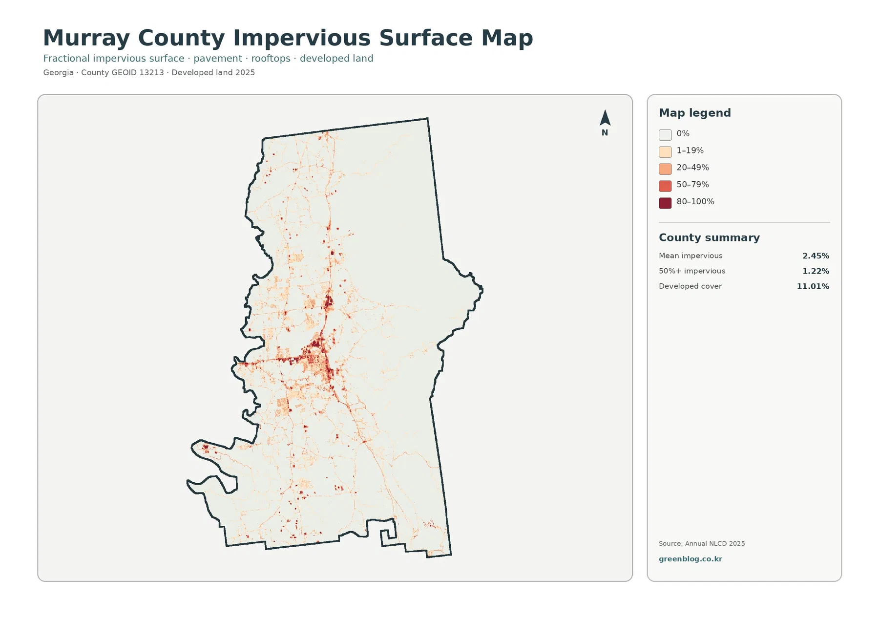
The largest dark cluster sits west of the county’s midpoint, where Georgia’s comprehensive plan identifies Chatsworth as the county seat. Hard-surface values spread north and south from the core and extend west along several road-shaped lines. The pattern becomes sparse quickly toward the eastern forest, making the contrast between the settlement corridor and the mountains particularly clear.
Mean impervious cover is 2.45%, and 1.22% of Murray County reaches 50% impervious surface or more. Developed land covers 11.01%. Those numbers differ because the developed classes can include lawns, trees, yards, and exposed ground, while impervious cover isolates roofs, pavement, parking areas, and similar hard surfaces.
Murray County maintains separate land-use and digital maps for zoning, permits, and rezoning. A hard-surface cluster shows where buildings and pavement concentrate; it does not establish a city limit, zoning district, or property line.
Eton and smaller western communities extend the settlement pattern northward
The joint county comprehensive plan includes Eton with Chatsworth as Murray County’s two incorporated cities. Eton sits north of Chatsworth, and current county information places Eton City Hall on U.S. Highway 411. On the maps, development and hard-surface traces continue north through the western side, while large agricultural blocks remain close to the settlement corridor.
The plan also lists unincorporated communities including Tennga, Cisco, Crandall, Spring Place, and Ramhurst. Small developed pockets are visible in several western and central locations. The raster does not print community names, however, so those patches should be discussed as dispersed rural settlement unless a separate place layer confirms the exact location.
The 1985–2025 endpoint map shows substantial change outside the developed class
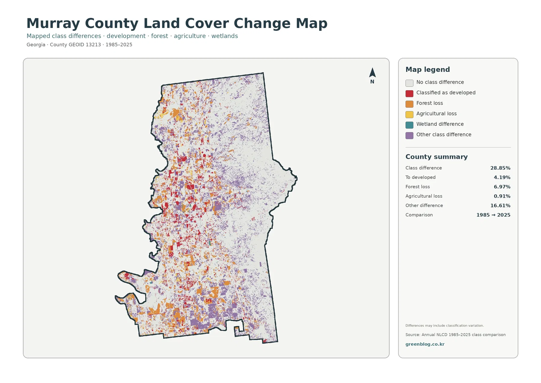
The total class difference between 1985 and 2025 is 28.85%. That figure counts raster cells assigned different classes at the two endpoints. It is not an urbanization rate and does not mean that 28.85% of Murray County was damaged or permanently converted. The map also notes that classification variation can be included.
The printed summary lists 16.61% other difference, 6.97% forest loss, 4.19% classified to developed, and 0.91% agricultural loss. Red developed-change cells are concentrated on the western side around the existing settlement corridor. Orange forest-loss and purple other-difference cells are distributed more broadly, especially through the west and south.
Wetland difference appears in the legend without its own printed percentage. The missing rate should not be reconstructed by subtraction and reported as official. A forest-loss label also does not identify its cause; development, timber activity, storms, regrowth cycles, and classification differences require intermediate imagery or local records before they can be separated.
Thirty-meter land cover is not a forest-ownership, parcel, or zoning map
Annual NLCD assigns one predominant class to each 30-meter raster cell. Mixed field edges, roads, small ponds, thin woods, and scattered buildings can therefore look simpler than they do on the ground.
The distinction is especially important in eastern Murray County. Green does not tell a reader whether land is inside Chattahoochee National Forest, Cohutta Wilderness, private timberland, or another ownership. Likewise, yellow does not define a farm parcel and red does not identify a zoning district. Site-specific decisions need current agency and county records.
Choosing the best map for Murray County’s east-west contrast
The 2025 countywide map is the best first image when the goal is to explain the broad eastern forest and the more varied western settlement and farm corridor. The vegetation view works better for agriculture-versus-forest comparisons. Use the impervious map when roofs and pavement around Chatsworth and Eton are the main subject, and reserve the endpoint map for a separate discussion of long-term classification differences.
Each JPG measures 2480 × 1754 pixels and works well for reports, lessons, and presentations. The package does not identify the files as meeting an A3 high-resolution reference, so a proof is advisable before large-format printing.
Frequently Asked Questions
What is the dominant land-cover class in Murray County?
Forest is the largest class in the supplied 2025 summary at 64.47%. Agriculture follows at 18.82% and developed land at 11.01%, with the most dramatic contrast between the forest-heavy east and the more mixed west.
Does every green cell in eastern Murray County belong to the national forest?
No. Forest Service sources confirm major national-forest and Cohutta Mountain landscapes east of Chatsworth, but Annual NLCD only classifies surface cover. Exact federal, wilderness, or private boundaries require official ownership and management maps.
Does the 28.85% endpoint difference mean that much of the county was developed?
No. It counts all cells with different class labels in 1985 and 2025. The summary separately lists 4.19% classified to developed, 6.97% forest loss, 0.91% agricultural loss, and 16.61% other difference.
Sources and Reference Data
- MRLC Annual NLCD Data – official access to annual land-cover and comparison products
- USGS Annual NLCD Land Cover Classification – definitions for forest, agriculture, developed land, wetlands, and related classes
- Georgia DCA – Murray County, Eton & Chatsworth Comprehensive Plans – official planning context for the county and its two incorporated cities
- Murray County – Land Use / Zoning – official county information on land-use standards, permits, rezoning, and digital mapping
- USDA Forest Service – Conasauga Ranger District – official context for the Cohutta Mountains northeast of Chatsworth and surrounding national-forest lands
- UGA Extension – Murray County Agriculture & Natural Resources – local agriculture, soil, water, forage, and natural-resource services
Map File Information
The ZIP contains four original JPG maps for comparing Murray County's 64.47% forest cover, western agriculture, Chatsworth-Eton development, impervious surfaces, and 1985–2025 class differences.
- Included Files: Use only the versions confirmed in the article and supplied images
- File Type: Use the confirmed download contents
- Intended Use: Printing, education, presentations, and map-based projects
Related Maps
- Appling County Georgia Land Cover Map
- Atkinson County Georgia Land Cover Map
- Bacon County Georgia Land Cover Map
Green Map creates custom-edited map images using open geographic data sources such as geoBoundaries, Natural Earth, OpenStreetMap, and government open data.
These maps are edited visual materials, not raw data files, and are provided for education, documents, presentations, and graphic reference.