Monroe County is heavily wooded in the supplied 2025 data, but two built settings make the map distinctive. Forest covers 63.87%, agriculture 11.21%, and developed land 9.77%. A broad settlement cluster occupies the west-central county around Forsyth, while Lake Juliette and a separate developed complex stand out in the northeast. This Monroe County Georgia Land Cover Map compares those areas with the surrounding forest, fields, wetlands, and water.
The page includes four WebP views: current land cover, forest and farmland, fractional impervious surface, and a 1985–2025 endpoint comparison. The four 2480 × 1754 JPG maps are available in one ZIP for lessons, reports, and presentations.
Table of Contents
Forsyth is the main settlement cluster, but it does not dominate the county
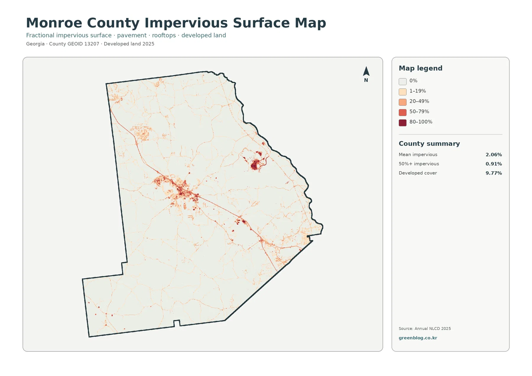
The impervious map places the largest settlement pattern west of the county center. Monroe County’s administration, Planning and Zoning office, courthouse, and several other county departments are based in Forsyth, which makes the city a useful reference for this cluster. Darker hard-surface cells occupy the center, while lighter values extend outward along several road-shaped corridors.
Hard surfaces fade quickly outside the cluster. Forest, farms, and low-density development surround the built area, so the county does not read as a continuously urbanized landscape. The raster does not draw the legal city boundary, and the edge of the colored cluster should not be treated as the municipal limit of Forsyth.
Mean impervious cover is 2.06%, and 0.91% of the county reaches 50% or more. Developed land covers 9.77%. The difference exists because developed classes can include lawns, trees, yards, and exposed soil, while fractional impervious cover focuses on roofs, pavement, parking areas, and other hard surfaces.
Lake Juliette creates a second, very different developed setting in the northeast
The northeast contains the county’s most obvious large water body and a concentrated developed area immediately to its north. Georgia Power identifies Plant Scherer as a Monroe County facility next to Lake Juliette, and company documents place the plant near the county’s northeastern edge. That official context matches the unusual water-and-developed combination visible in this part of the map.
Lake Juliette is described in Georgia Power material as a manmade lake created in connection with the plant. On the land-cover view, open water is surrounded by forest and smaller wetland patches, while the developed complex forms a sharp contrast on the north side. This setting should not be interpreted like the Forsyth settlement cluster because the land uses behind the two built patterns are different.
Forest is the dominant countywide class at 63.87%
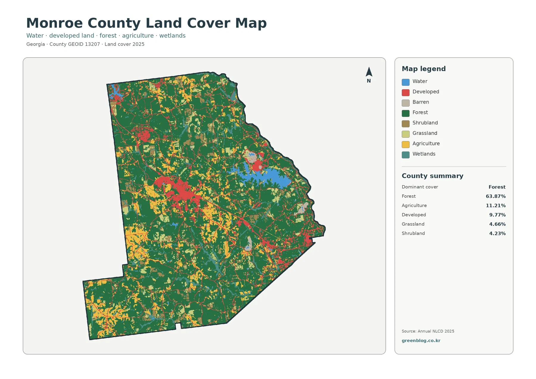
Forest covers nearly two-thirds of the county. Large dark-green areas continue through the north and south, and woodland remains common even near the main settlement and farm areas. Development and agriculture therefore appear as openings and corridors within a forest-heavy landscape rather than as two large regions replacing the woods.
Agriculture accounts for 11.21%. Yellow blocks are visible in the north, west, and south-central areas, with smaller patches scattered farther east. The fields are repeatedly separated by forest, grassland, and low-density development. That pattern is more useful than describing Monroe County as a simple agricultural-versus-forest split.
Grassland is 4.66% and shrubland 4.23%. Wetlands add 3.39%, while open water accounts for 2.36% in the vegetation summary. The large northeastern lake makes the water share visually prominent.
The vegetation view makes farm openings easier to see within the forest
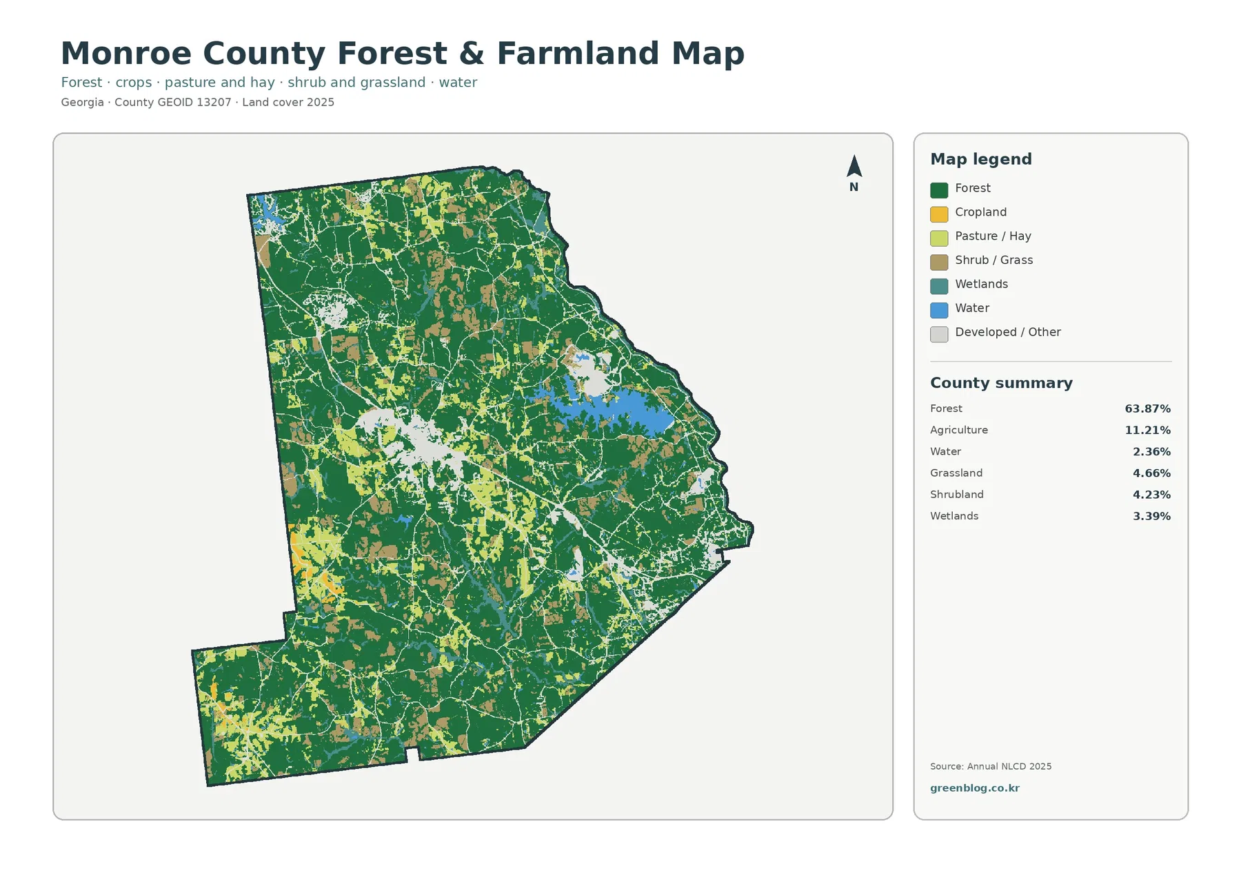
With the developed class reduced, large forest blocks become even more continuous. Agricultural openings stand out in the northern and western portions and continue through the south-central county. Grass and shrub cover fill some of the transitions between farms and woods, producing a varied rural surface rather than one uninterrupted field belt.
The northeast is different because water, forest, and the developed complex sit close together. Farmland is less visually dominant around Lake Juliette than in many western and central areas. That contrast makes the vegetation map useful for showing that Monroe County’s rural landscape changes substantially from one part of the county to another.
Annual NLCD uses 30-meter raster cells. A cell can contain trees, a field edge, grass, a road, and part of a building even though it receives one predominant class. Small ponds, narrow streams, thin wooded strips, and scattered structures can therefore look simplified at county scale.
The 1985–2025 difference map is far more widespread than the developed-change pattern
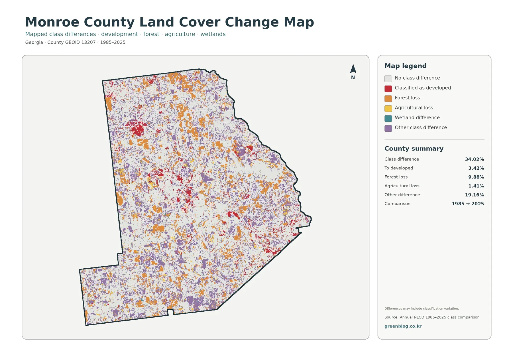
The total endpoint class difference is 34.02%. This number counts raster cells assigned different classes in 1985 and 2025. It is not the share of Monroe County that was damaged, cleared, or developed, and it should not be subtracted from the current 63.87% forest value to estimate an earlier forest percentage.
The printed summary lists 19.16% other difference, 9.88% forest loss, 3.42% classified to developed, and 1.41% agricultural loss. Developed-change red is most concentrated around Forsyth, the Lake Juliette area, and several road-oriented pockets. Orange forest-loss and purple other-difference cells are spread much more widely across the county.
Wetland difference appears in the legend without a separately printed percentage. The missing value should not be reconstructed by subtraction and presented as official. The map also notes that classification variation may occur, so image date, seasonal conditions, mixed pixels, and classification choices can contribute to some endpoint differences.
High Falls adds another water-and-forest context on the county’s broader landscape
Georgia State Parks identifies High Falls State Park as a park spanning Monroe, Lamar, and Butts counties and describes High Falls Lake on the Towaliga River. That official context is useful when considering the smaller water-and-forest features toward the northwestern side of Monroe County. The land-cover image itself does not label the park boundary or the Towaliga River.
Land cover is not zoning, ownership, or a facility boundary
Forest color does not identify ownership or protected land, agricultural color does not define a farm parcel, and developed color does not show zoning. Around Plant Scherer, official facility maps are still required for exact boundaries.
The supplied map is a 2025 snapshot. Later construction, clearing, regrowth, or field changes may be absent, and the 30-meter classification is not a parcel survey.
Frequently Asked Questions
What is the dominant land-cover class in Monroe County?
Forest is the largest class in the supplied 2025 summary at 63.87%. Agriculture follows at 11.21% and developed land at 9.77%, while water and wetlands occupy smaller but locally important areas.
Why is developed land 9.77% while mean impervious cover is only 2.06%?
Developed classes can include trees, lawns, yards, and bare ground around buildings and roads. The impervious layer measures the harder surfaces such as roofs, pavement, and parking areas.
Does the 34.02% endpoint difference measure forest loss or urban growth?
No. It counts all cells with different class labels in 1985 and 2025. The summary separately lists 19.16% other difference, 9.88% forest loss, 3.42% classified to developed, and 1.41% agricultural loss.
Sources and Reference Data
- MRLC Annual NLCD Data – official access to annual land-cover and comparison products
- USGS Annual NLCD Land Cover Classification – definitions for forest, agriculture, developed land, wetlands, and related classes
- U.S. Census Bureau TIGER/Line Shapefiles – authoritative county, place, and transportation layers for comparison
- Monroe County – Directory – official county administration and Planning and Zoning locations in Forsyth
- Georgia Power – Plant Scherer – official facility information for the Monroe County plant beside Lake Juliette
- Georgia State Parks – High Falls State Park – official context for High Falls Lake, the Towaliga River, and the park spanning Monroe, Lamar, and Butts counties
Map File Information
The ZIP contains four original JPG maps for comparing Monroe County's 63.87% forest cover, agriculture, the Forsyth settlement, Lake Juliette and nearby development, impervious surfaces, and 1985–2025 class differences.
- Included Files: Use only the versions confirmed in the article and supplied images
- File Type: Use the confirmed download contents
- Intended Use: Printing, education, presentations, and map-based projects
Related Maps
- Appling County Georgia Land Cover Map
- Atkinson County Georgia Land Cover Map
- Bacon County Georgia Land Cover Map
Green Map creates custom-edited map images using open geographic data sources such as geoBoundaries, Natural Earth, OpenStreetMap, and government open data.
These maps are edited visual materials, not raw data files, and are provided for education, documents, presentations, and graphic reference.