Manatee County Map resources on this page connect Bradenton, Palmetto, the Gulf Coast islands, major roads, and the county’s river system in three complementary views. The county stretches from the barrier-island coast and the southern side of Tampa Bay far into inland Florida, so a single map can make the western urban area look much closer to the eastern interior than it feels on the ground. The maps below separate county-and-road context, the distribution of incorporated cities, and waterways. High-resolution JPG versions of all three maps are available together in the ZIP download farther down the page.
The clearest geographic anchor is the Manatee River. Bradenton sits on the south side of the river, while Palmetto lies on the north side, and the US 41 and US 301 corridors tie the two sides together. West of Bradenton, Anna Maria Island forms a narrow coastal chain with Anna Maria, Holmes Beach, and Bradenton Beach. Longboat Key extends south toward Sarasota County. East of Interstate 75, the settlement pattern becomes more spread out, with Lakewood Ranch and broad inland areas replacing the dense cluster of coastal place names.
Table of Contents
A county organized around river, coast, and east-west corridors
The county map makes the west-to-east contrast immediately visible. Around Bradenton, Palmetto, Ellenton, and the coastal islands, place names and roads are closely spaced. East of I-75, road spacing increases and the map shows a much larger area with fewer major settlement labels. SR 64 and SR 70 are the most useful east-west references: SR 64 runs east from Bradenton through the middle of the county, while SR 70 crosses farther south through the Lakewood Ranch area and continues toward the interior. SR 62 provides another east-west route in the northern part of the county.
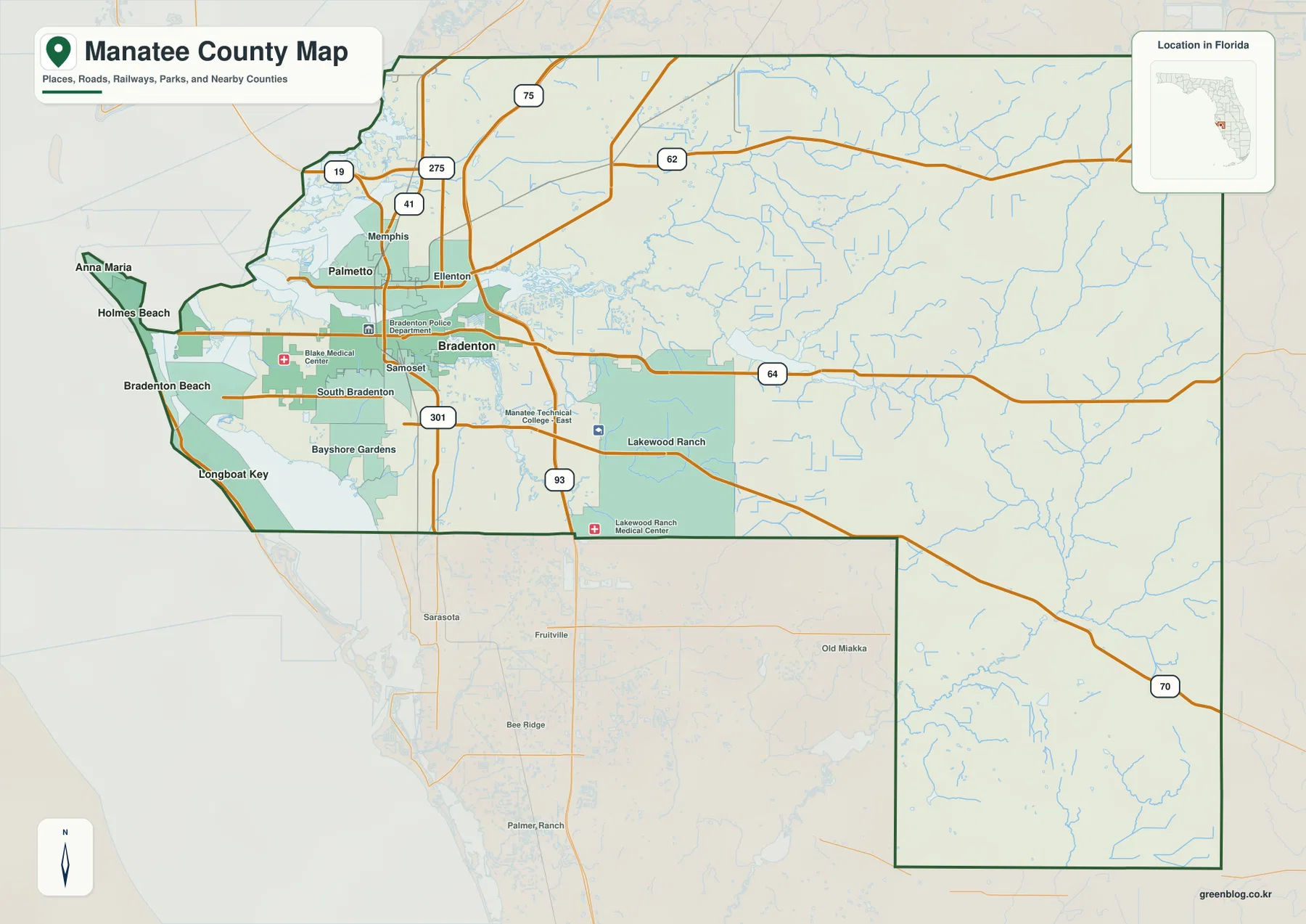
On the western edge, the county is shaped by bays, islands, and narrow strips of land rather than a simple straight shoreline. Anna Maria, Holmes Beach, and Bradenton Beach line up along Anna Maria Island, while Longboat Key continues south from the same general coastal zone. On the mainland, Palma Sola Bay cuts into the coast west of Bradenton, and Terra Ceia Bay lies farther north near the lower part of Tampa Bay. This arrangement explains why a route that looks short in a straight line can still depend on a bridge or a specific mainland connection.
Farther inland, I-75 is the main north-south highway and sits well east of the older Bradenton-Palmetto core. That detail matters when reading travel patterns. Interstate trips toward Tampa or Sarasota can remain on the eastern side of the urban area, while a trip to downtown Bradenton or the island beaches requires a westward move on routes such as SR 64 or SR 70. I-275 appears in the northwestern part of the county and points toward the Sunshine Skyway and the Tampa Bay crossing, adding a separate regional connection from the local street network.
The city map highlights a compact group of western communities
The city distribution map ranks six incorporated municipalities: Bradenton, Palmetto, Longboat Key, Holmes Beach, Anna Maria, and Bradenton Beach. Bradenton is the largest and is positioned inland from the Gulf-facing barrier islands, while Palmetto sits across the Manatee River to the north. The four smaller coastal municipalities occupy narrow island or shoreline locations. Seeing them on one map is useful because the continuous developed coastline can otherwise make several distinct cities look like one long beach community.
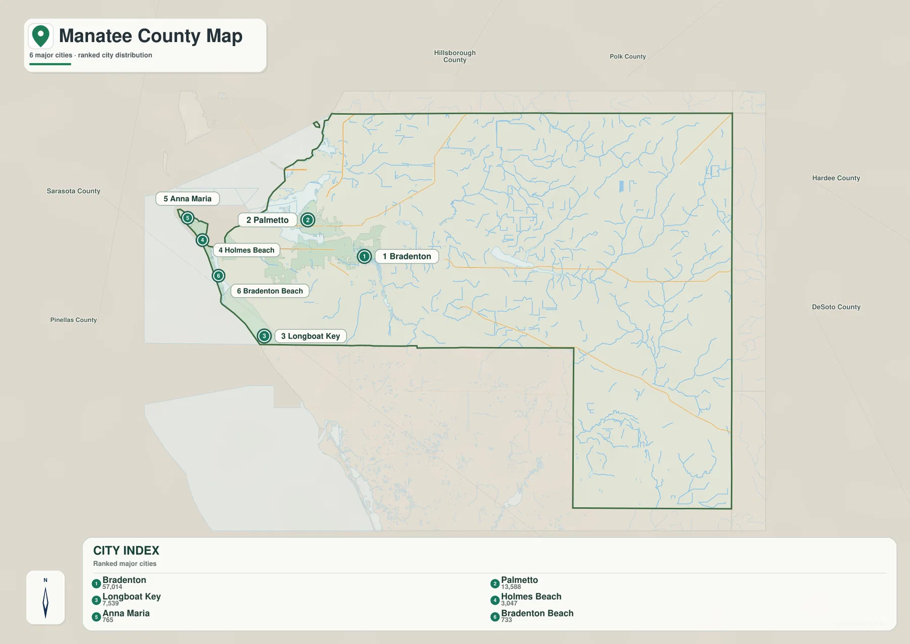
Lakewood Ranch illustrates an important difference between the city map and the broader county map. It is prominent on the county map east of I-75, but it does not appear in the six-city ranking in the same way as the incorporated municipalities. In practical terms, that means a large, recognizable community may be central to how residents describe the county without being represented as a separate incorporated city on this particular city index. Comparing the two map types prevents the common mistake of treating every large community label as the same kind of municipal unit.
The neighboring counties also help orient the city pattern. Hillsborough County is to the north, Polk County to the northeast, Hardee County to the east, DeSoto County to the southeast, and Sarasota County to the south. Nearly all of the six ranked cities cluster toward the western side rather than the inland borders. This concentration is one reason the county outline can appear much larger than the part most visitors associate with Bradenton and the beaches.
From the Manatee River to Tampa Bay and the Gulf-facing inlets
The water map shifts attention away from roads and municipalities and toward the drainage network. The Manatee River is the central feature, running from the inland portion of the county toward the west and reaching the bay between the Bradenton and Palmetto areas. Its North Fork is labeled farther east, while Gamble Creek appears in the northeastern interior. The South Fork Little Manatee River is mapped near the northern side, and the Myakka River appears along the southeastern edge of the broader mapped area. Braden River, south of the Manatee River, is another important watercourse close to the developed part of the county.
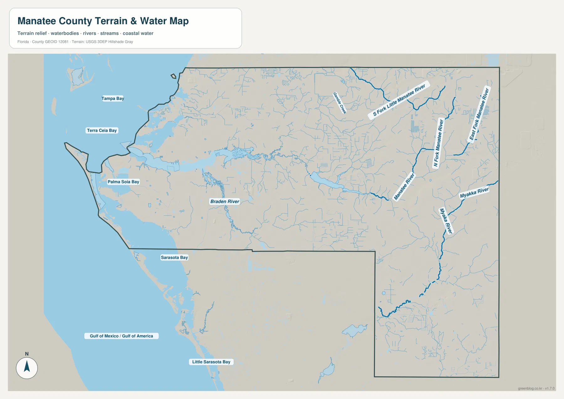
The coastal water names explain the shape of the western boundary. Tampa Bay occupies the northwest side, Terra Ceia Bay reaches into the coast below it, and Palma Sola Bay sits west of the Bradenton area. Sarasota Bay and Little Sarasota Bay continue south beyond the county’s main shoreline context. Longboat Key lies across this transition toward Sarasota County, while Anna Maria Island sits farther north. These bays and islands are not decorative background features; they determine where bridges and road approaches can exist, and they separate communities that may appear almost adjacent when viewed only by straight-line distance.
This water layer is a geographic reference, not a flood-risk, parcel, bathymetric, or navigation chart. It is best used to answer questions such as which river lies between two communities, whether a bay or river explains a gap in the road network, and how inland streams connect toward the coast. Flood zones, channel depths, legal shoreline boundaries, and engineering decisions require separate authoritative products designed for those purposes.
Reading the roads that connect the coast with the interior
US 41 and US 301 are especially useful for understanding the older Bradenton-Palmetto-Ellenton corridor. Both help cross or approach the Manatee River area, while I-75 runs farther east and carries regional traffic north and south. SR 64 leaves Bradenton and extends east across the county, making it the clearest reference for locating the central inland section. SR 70 crosses the southern part of the county and passes the Lakewood Ranch area. SR 62 serves the northern interior. Together, these routes show why “east Manatee County” covers several different corridors rather than one single suburban strip.
The western islands require a different reading. Their access depends on causeways and bridges from the mainland, so the road network narrows as it approaches the coast. A visitor going to Anna Maria Island does not simply continue west from I-75 on any local road; the usable routes funnel toward specific crossings. In the same way, Longboat Key runs north-south along the coast and continues into Sarasota County, so its relationship to the county boundary is unlike the inland grid around Bradenton or Lakewood Ranch.
Which Manatee County map is best for your task?
Choose the county map when you need boundaries, communities, and major highways in one frame. It is the strongest choice for comparing Bradenton, Palmetto, Ellenton, Lakewood Ranch, and the routes leading toward neighboring counties. Use the city distribution map when the goal is to identify the incorporated cities and see how strongly they cluster in the west. Choose the water map when rivers, bays, and coastal water are the main subject. Switching between the three is often more informative than trying to extract every answer from a single crowded map.
The downloaded JPGs are larger than the web previews and are better suited to zooming in on place names, roads, and river labels. They are still general-reference maps rather than legal surveys, parcel maps, navigation charts, or engineering documents. For decisions involving property boundaries, flood regulation, construction, or marine navigation, use the specialized official data issued for those purposes.
Frequently Asked Questions
What is the easiest way to tell Bradenton and Palmetto apart on the map?
Use the Manatee River as the main reference. Bradenton is on the south side of the river and Palmetto is on the north side. The US 41 and US 301 corridors link the two sides, so finding the river first makes the nearby city labels much easier to interpret.
Which cities are shown along Anna Maria Island?
Anna Maria, Holmes Beach, and Bradenton Beach are shown in sequence along Anna Maria Island. They are separate municipalities even though the developed island corridor can look continuous at a small scale. Longboat Key lies farther south and extends toward Sarasota County, so it should not be treated as the same island-city group.
Which file should I use to trace the Manatee River and nearby bays?
The water map is the best choice for the Manatee River, Braden River, Tampa Bay, Terra Ceia Bay, Palma Sola Bay, and other mapped waterways. Use the county map alongside it when you also need roads and community names. The water map is a location reference and is not intended to replace flood, depth, or navigation data.
Map File Information
The download contains the original high-resolution JPG versions of the county map, city map, and water map shown on this page.
- Included Files: county map, city map, water map
- File Type: ZIP containing 3 JPG files
Related Maps
- Arcadia Roads and Peace River | DeSoto County Florida Map
- Baker County Florida Map
- Between the Aucilla and Withlacoochee: Madison County Florida Map
Sources and References
- Manatee County Government
- Manatee County GIS Interactive Map Gallery
- Florida Department of Transportation – Manatee County transportation network
- Florida Department of Environmental Protection – Manatee River basin material
- U.S. Census Bureau QuickFacts – Manatee County
Green Map creates custom-edited map images using open geographic data sources such as geoBoundaries, Natural Earth, OpenStreetMap, and government open data. These maps are edited visual materials, not raw data files, and are provided for education, documents, presentations, and graphic reference.