Bartow County sits northwest of Atlanta where the Cartersville area, the Interstate 75 corridor, the Etowah River, Lake Allatoona, and a much rougher eastern landscape meet inside one county boundary. This page separates those features into four maps so the reader can see roads and places, the distribution of major cities, waterways, and elevation without forcing every detail onto a single sheet. The same four maps are available as high-resolution A3 JPG files in one downloadable ZIP.
Cartersville is the easiest place to use as an anchor. Adairsville lies to the north, White to the northeast, Kingston to the west, Euharlee to the southwest, and Emerson to the south. Lake Allatoona cuts into the eastern and southeastern side of the county with a highly branched shoreline, while the elevation map shows that the eastern ridges rise sharply above the lower river valleys farther west.
Table of Contents
Cartersville and the county’s main road pattern
The general county map is the best starting point because it combines the county outline with towns, principal roads, streams, developed areas, and a small Georgia locator. Cartersville appears slightly southeast of the county’s center and forms the strongest road junction on the sheet. Interstate 75 runs north from Emerson through the Cartersville area toward Adairsville, with US 41 following the same broad north-south corridor. US 411 crosses Cartersville and connects the county westward and northeastward, while State Routes 20, 61, 113, 140, and 293 help connect the lake side, western communities, and the central city.
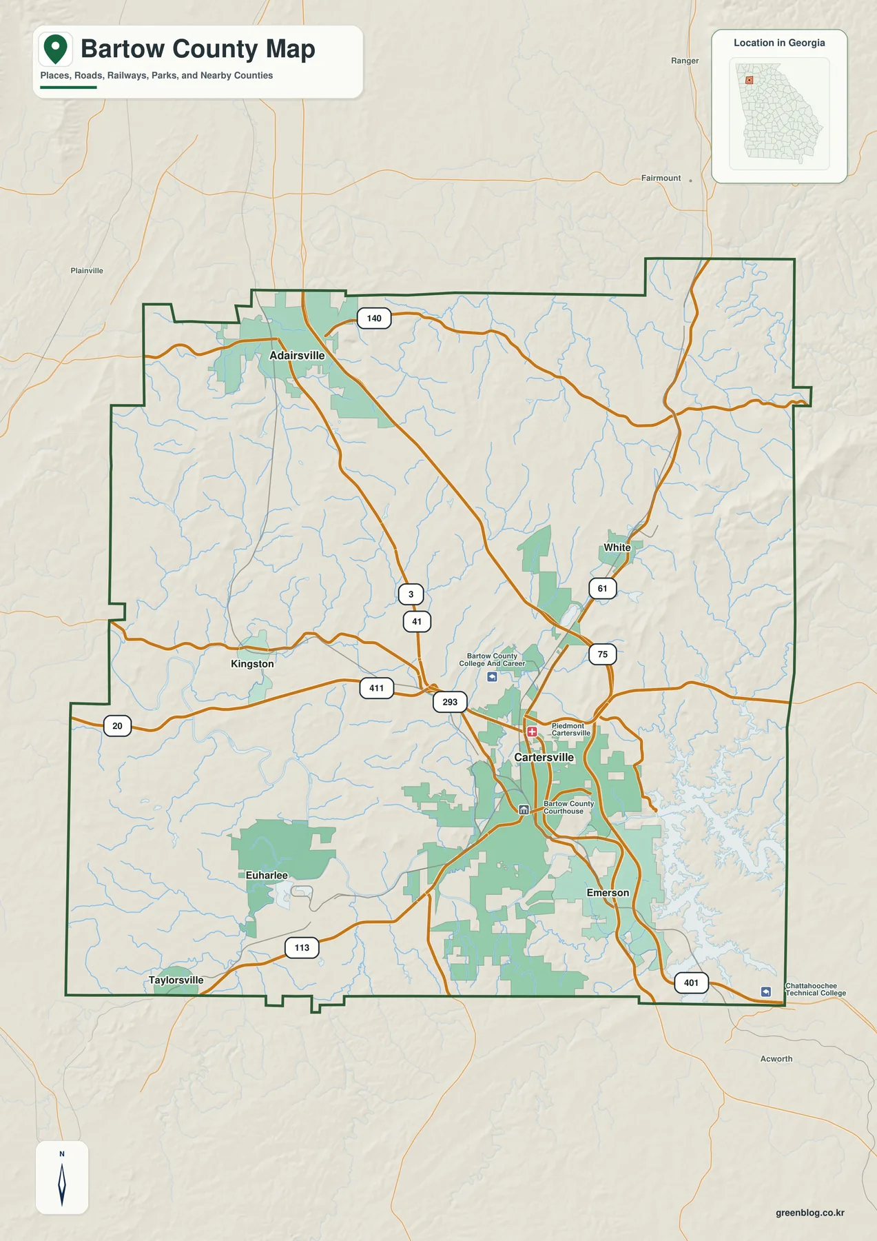
The map makes the settlement pattern easier to understand when the cities are read together with the roads. Adairsville is close to the I-75 and US 41 corridor in the north. White is northeast of Cartersville near the US 411 side of the county, while Kingston and Euharlee sit west of the main interstate-centered urban band. Emerson is immediately south of Cartersville and close to I-75. Taylorsville also appears near the southwestern edge on the general map, even though it is not one of the six cities emphasized on the ranked city sheet.
Neighboring counties help place Bartow within northwestern Georgia. Gordon is to the north, Cherokee and Pickens are on the eastern side, Cobb and Paulding lie toward the southeast and south, and Polk and Floyd are to the west and southwest. That position puts Bartow between the Atlanta metropolitan fringe, the Rome area, and routes that continue north toward the Appalachian foothills. The map is useful for countywide orientation, but it is not a legal parcel, zoning, school-district, flood, or incorporated-city boundary map.
Six major cities spread across different parts of Bartow County
The city map removes some of the general-map detail and ranks six major cities so their relative positions are easier to compare. Cartersville is first and occupies the central-southeastern part of the county. Adairsville is second in the north, Euharlee is third in the southwest, Emerson is fourth south of Cartersville, Kingston is fifth in the west, and White is sixth in the northeast. The city index on the map also provides a compact population reference, but the geographic pattern is more important for map reading than the ranking itself.
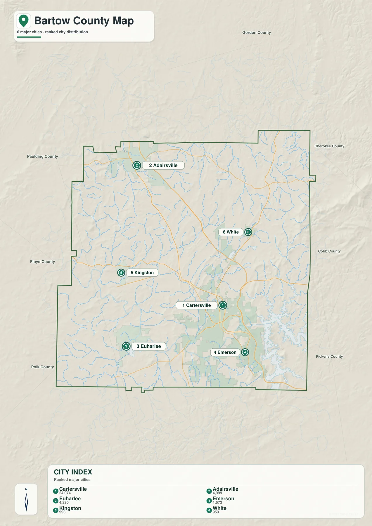
Cartersville and Emerson form the closest pair along the southern I-75 corridor, while Adairsville is separated from them by a longer stretch of the county to the north. Euharlee and Kingston show how far settlement extends west of the main interstate route. White occupies a different position to the northeast, closer to the ridged terrain and the roads approaching the lake-facing side. This makes the city sheet useful for classroom location work, county orientation, and presentations where a full road network would add more detail than the audience needs.
The ranked sheet should not be treated as a complete municipal inventory. Taylorsville, for example, is visible on the general county map near the southwestern boundary but is not included in the six-city ranking. When a specific place is the goal, compare the city sheet with the general map rather than assuming that every community is represented by a numbered marker.
Etowah River, Lake Allatoona, and the county’s branching creeks
Water becomes the dominant feature on the eastern side of Bartow County. Lake Allatoona and the Allatoona Reservoir occupy a broad, branched area along the east and southeast, with narrow arms extending between ridges. The Etowah River crosses the county farther west, tying the lake system to the river valley that continues toward Rome. On the western side, Euharlee Creek and Two Run Creek feed into the larger drainage network, while many smaller tributaries cross the interior.
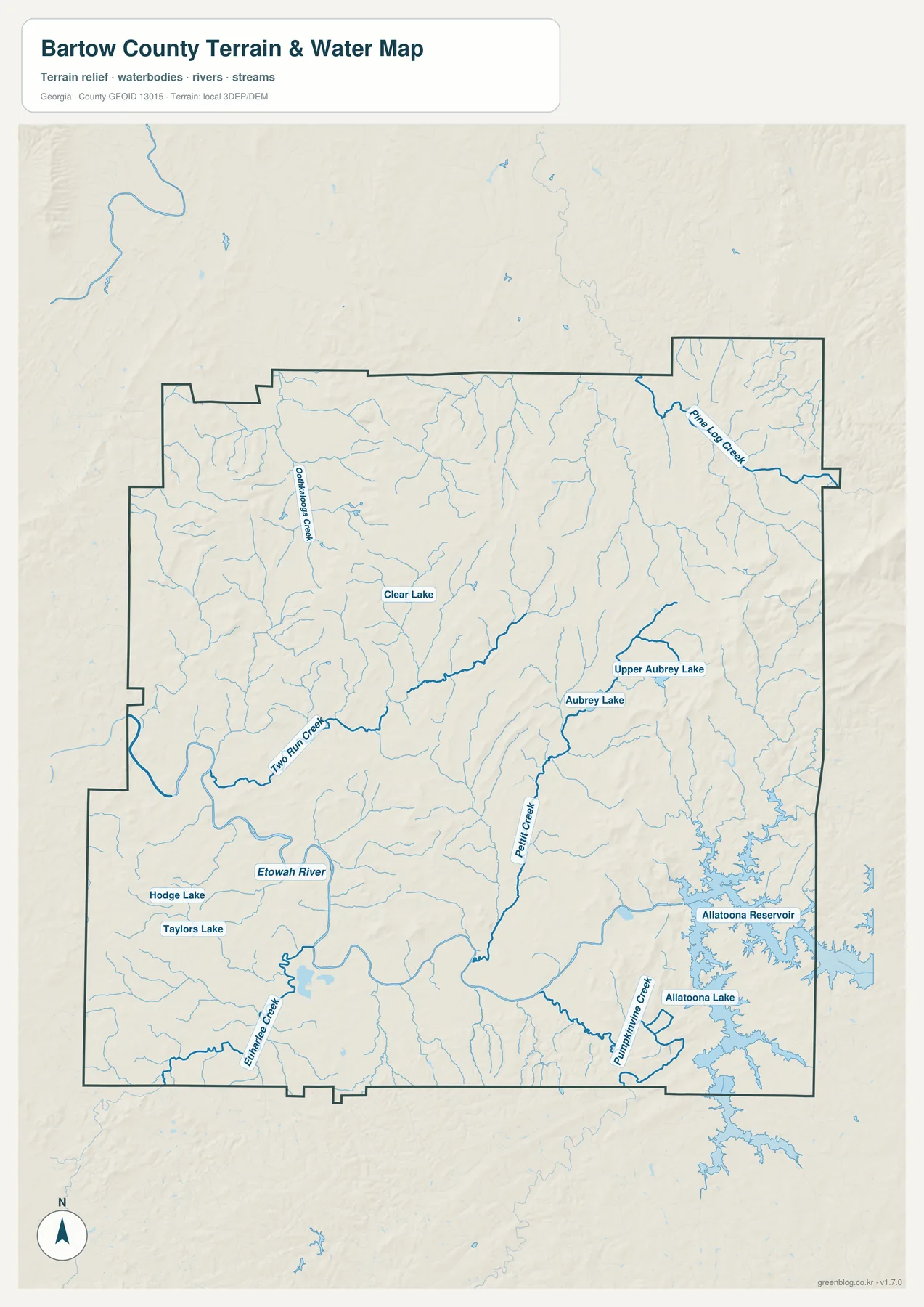
Pettit Creek is labeled near the central-eastern part of the county, and Pumpkinvine Creek approaches the Allatoona system in the southeast. Pine Log Creek is prominent in the northeast. The map also labels Aubrey Lake, Upper Aubrey Lake, Clear Lake, Hodge Lake, and Taylors Lake, which helps show that the county’s water geography is not limited to one reservoir and one river. The many small blue tributaries make the connection between local valleys and the larger Etowah-Allatoona system visible at a county scale.
This sheet is a water-location and terrain reference, not a flood-risk map, navigation chart, water-quality product, or legal shoreline survey. A winding reservoir shore can cross administrative boundaries and property lines in complicated ways. Anyone making a decision about an address, floodplain, access point, or legal jurisdiction should use the current layers from the responsible county, state, or federal agency.
Elevation rises from the river valleys toward the eastern ridges
The elevation map reveals a much stronger terrain contrast than the road map alone suggests. Its summary reports actual elevations of about 181 to 628 meters, with a mean near 259 meters. Lower terrain is widespread through the western and southwestern river valleys, while higher ground becomes much more pronounced on the eastern side. The northeast also contains elevated ridges, and the strongest brown shaded areas show steep terrain close to the eastern boundary.
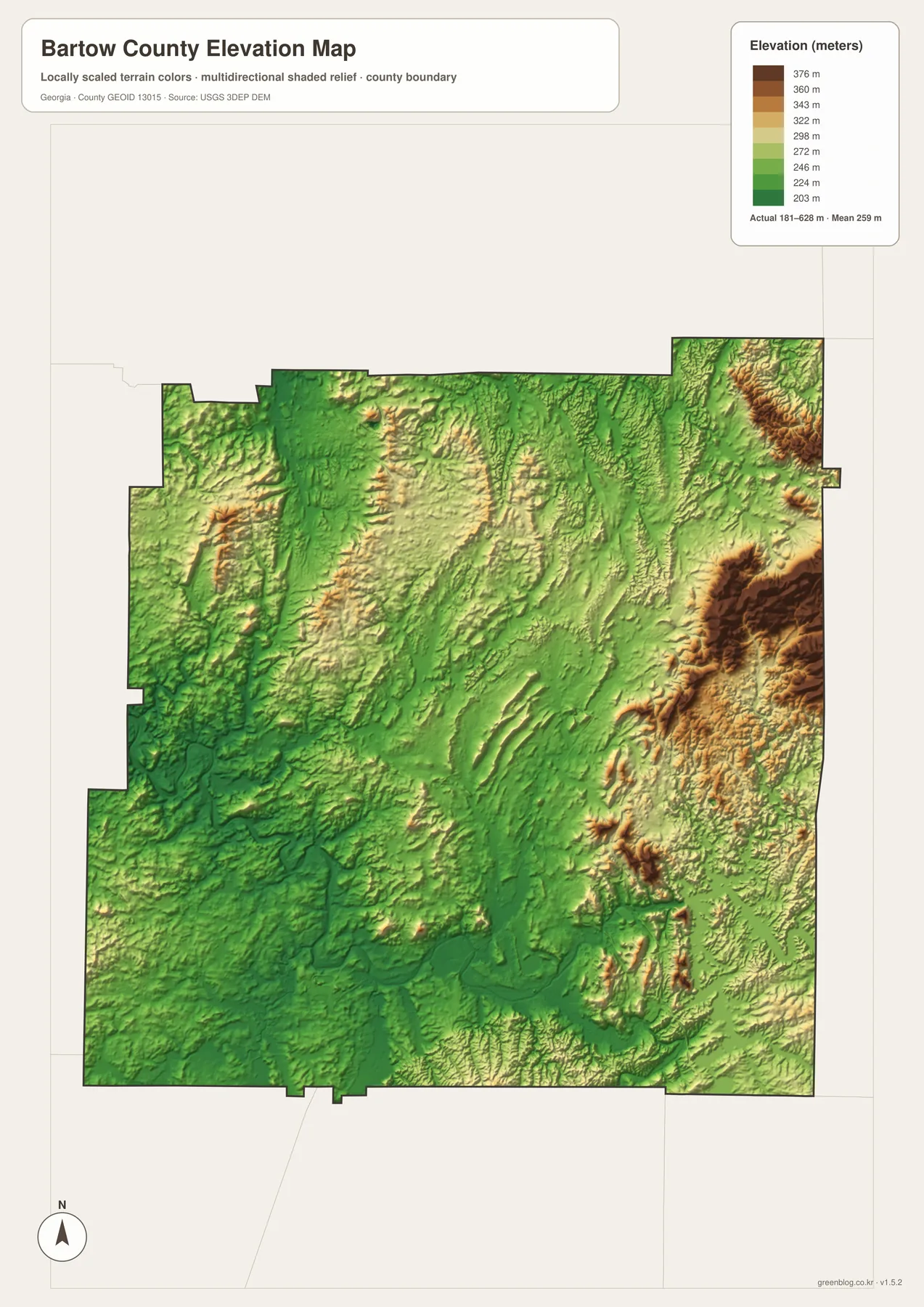
Cartersville and the Etowah corridor sit in relatively lower terrain than the high ridges to the east. The map also shows long, narrow landforms across the northern and central parts of the county, which helps explain why roads and streams often follow valleys rather than crossing every ridge directly. Around Lake Allatoona, the water fills low ground between higher slopes, so the reservoir’s irregular outline and the elevation pattern make more sense when the water and terrain maps are viewed together.
The color ramp is locally scaled for Bartow County and should not be compared directly with the same color on a map of another county. It is also a generalized elevation surface based on USGS 3DEP information, not survey-grade measurement. Use it for countywide terrain interpretation, teaching, and visual reference. Engineering, construction, or property work requires the appropriate source elevation data or a professional survey.
How to choose the most useful Bartow County map
Use the general map when the task begins with roads, named places, and the county boundary. The city map is cleaner when the goal is to compare where the major cities sit without carrying every road label into the discussion. The water sheet is better for explaining the Etowah River, Lake Allatoona, and the creek network, while the elevation sheet is the strongest choice for showing why the eastern side looks and feels more rugged than the lower western valleys.
For a classroom exercise, a useful sequence is to locate Cartersville and the county boundary first, compare the six city markers second, and then add the water or elevation sheet depending on the lesson. For travel or local orientation, begin with the road map and then use the water and relief maps for the Lake Allatoona or Red Top Mountain area. These maps are intentionally county-scale references; legal boundaries, parcel ownership, flood information, and precise engineering elevations should come from current authoritative datasets.
Frequently Asked Questions
Is all of Lake Allatoona inside Bartow County?
No. The reservoir occupies a large part of the eastern and southeastern map, but the entire lake is not confined to Bartow County. Use the general boundary map and the water map for county-scale orientation, and consult current administrative data when exact jurisdiction matters.
Why does the city map leave out Taylorsville?
The city sheet is a ranked display of six major cities rather than a complete list of every municipality or community. Taylorsville is labeled on the general map near the southwestern boundary, so the two maps are meant to be used for different levels of detail.
Can the elevation map be used for construction or surveying?
No. It is designed to show countywide relief and the contrast between valleys and higher ridges. Precise design elevations, parcel work, or construction decisions require source elevation data and, when appropriate, a professional survey.
Map File Information
Bartow County A3 JPG map set
- Included Files: 4 high-resolution A3 JPG map files shown in this article
- File Type: JPG files in a ZIP archive
- Intended Use: Printing, education, presentations, and map-based projects
Related Maps
Sources and references
- U.S. Census Bureau QuickFacts – Bartow County for county population and general statistics.
- New Georgia Encyclopedia – Bartow County for county formation and regional history.
- Georgia Department of Community Affairs for Bartow County and municipal planning resources.
- Georgia State Parks – Red Top Mountain for the Lake Allatoona and Red Top Mountain area.
- USGS National Hydrography for water-feature reference data.
- USGS 3D Elevation Program for elevation and terrain data.
Green Map creates custom-edited map images using open geographic data sources such as geoBoundaries, Natural Earth, OpenStreetMap, and government open data. These maps are edited visual materials, not raw data files, and are provided for education, documents, presentations, and graphic reference.