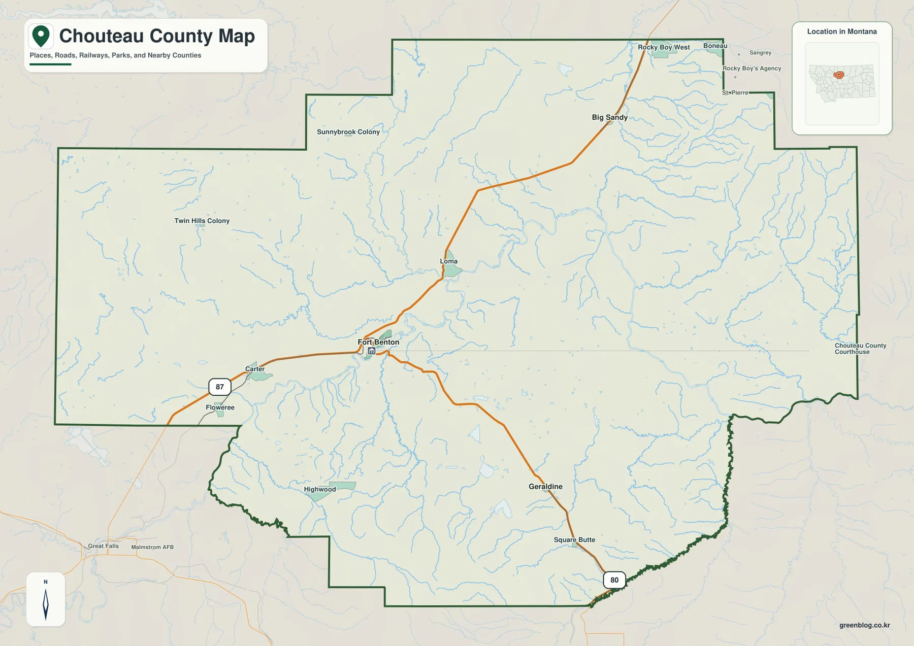
Chouteau County stretches across a large part of north-central Montana, with Fort Benton sitting near a major bend of the Missouri River and serving as the clearest map reference. Roads run northeast through Loma toward Big Sandy, southeast toward Geraldine and Square Butte, and west toward Carter and Floweree. The water map adds another layer: the Teton River approaches from the west, the Marias River crosses the north, and Big Sandy Creek drains the northeastern part of the county. High-resolution JPG versions of the maps shown here are available together in the download ZIP below.
Fort Benton is the easiest place to begin because both the road map and the water map converge around it. The Missouri River passes the city, the Teton River approaches nearby, and the route toward Loma leads toward the Marias River area. The city-connections map also uses Fort Benton as its hub, linking it directly to Big Sandy and Geraldine. From that single reference point, the county can be divided into northern plains, eastern creek country, southern uplands, and the river corridor through the center.
Table of Contents
Roads from Fort Benton split toward Big Sandy, Geraldine, and the western plains
On the general county map, Fort Benton sits slightly west of center. U.S. 87 is labeled on the western side near Floweree and Carter, while the road leaving Fort Benton to the northeast passes Loma before continuing toward Big Sandy. A separate road heads southeast from Fort Benton toward Geraldine and Square Butte. These three directions provide a simple framework for a county whose boundary reaches far beyond the main towns.
The northeast road continues into a more irregular boundary area beyond Big Sandy, where labels such as Rocky Boy West, Boneau, and St. Pierre appear near the county edge. Sunnybrook Colony is shown farther northwest, while Twin Hills Colony appears in the broad western interior. These smaller place names are useful for orientation, but the county boundary should be watched closely because several labels sit near stepped or projecting sections of the outline.
South of Fort Benton, the road toward Geraldine continues to Square Butte and the southeastern edge, where Route 80 is labeled. Highwood lies separately in the southwest. The full county map is useful for seeing these directions at once, but it is not a live navigation product. Construction, seasonal road conditions, and actual drive times should be checked with current transportation information before travel.
The city map compares Big Sandy and Geraldine from a Fort Benton hub
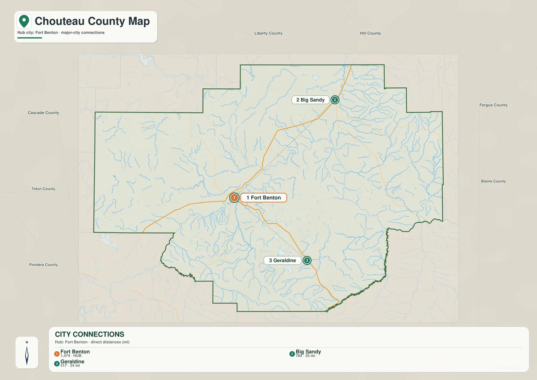
The city-connections map ranks Fort Benton first and links it to Big Sandy and Geraldine. Its printed index shows values of 1,474 for Fort Benton, 784 for Big Sandy, and 317 for Geraldine. These are the population values embedded in the supplied map and should not be treated as guaranteed current estimates. For current demographic figures, consult recent U.S. Census Bureau data.
The map labels Big Sandy at 35 miles from Fort Benton and Geraldine at 24 miles. Those are straight-line distances, not road mileage. Big Sandy lies northeast of Fort Benton, while Geraldine lies southeast, so the two connections follow different directions as well as different lengths. Actual driving distances will be longer where roads curve around terrain or follow established corridors.
The connection lines are most useful for quick scale and orientation. Big Sandy is clearly the farther of the two ranked destinations, while Geraldine is closer and sits in the southern half of the county. Loma, Square Butte, and smaller communities are not part of the ranked connection table, so the general county map remains the better choice when more local detail is needed.
The Missouri River ties Fort Benton to the central county landscape
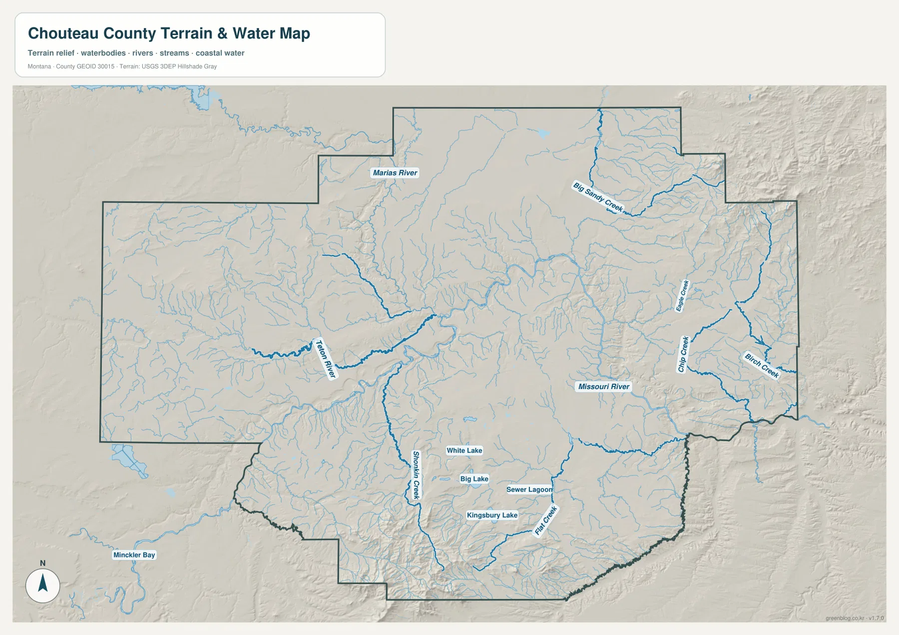
The terrain-and-water map makes the Missouri River the dominant feature through the middle of Chouteau County. It enters from the west, curves through the Fort Benton area, and continues east and southeast across the county. The Teton River approaches from the west and meets the larger river system near Fort Benton, making the city useful not only as a road reference but also as a water reference.
South of Fort Benton, Shonkin Creek forms a long drainage into the rougher southern interior. Flat Creek appears farther southeast, while White Lake, Big Lake, Kingsbury Lake, and a few other small water bodies provide local reference points in the same broad area. These features are small compared with the Missouri, but they make it easier to identify the southern uplands on a detailed map.
Farther east, the Missouri River is joined by numerous short tributaries descending from higher ground. The elevation map shows many of those creek valleys as narrow lower cuts through surrounding uplands. This terrain-and-water map is intended for geographic reference; it should not be used as a flood-hazard map, navigation chart, parcel survey, water-rights record, or guide to safe crossings.
Marias River and Big Sandy Creek organize the northern half
The Marias River is one of the main northern waterways on the map. It runs across the north-central portion of the county and approaches the Missouri River system in the Loma area. Comparing the water map with the road map makes this northern layout easier to understand: the route from Fort Benton to Loma and Big Sandy crosses the same broad part of the county in which the Marias and its tributaries are important landmarks.
Big Sandy Creek is the strongest named drainage in the northeast. It runs through a network of smaller tributaries near Big Sandy and continues toward the eastern side of the county. Chip Creek and Birch Creek are labeled farther east, and Beaver Creek appears to the north. The drainage network is denser here than around some of the open western plains, so locating Big Sandy Creek first helps organize the smaller names.
Fort Benton’s local visitor information describes the town as an important historic Missouri River port and a gateway to the Upper Missouri region. That background fits the map well. Fort Benton lies where the river corridor and overland routes come together, while the Marias River and the Upper Missouri country extend outward from the same general part of north-central Montana.
Elevation runs from about 729 to 2,321 meters
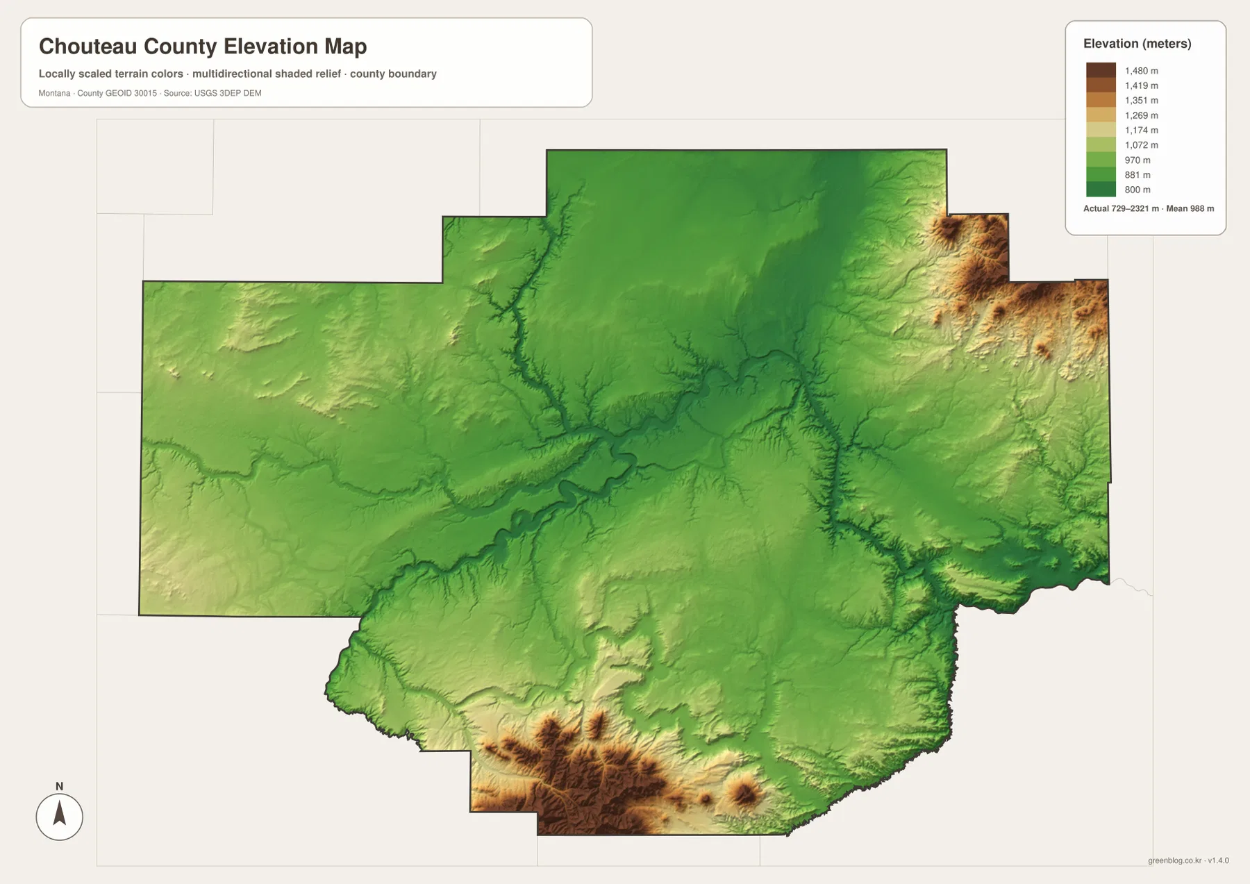
The elevation map reports an actual county range of about 729 to 2,321 meters, with a mean elevation near 988 meters. Much of the central and northern county appears in lower green tones, and the Missouri River corridor is visible as a long low band. Higher yellow and brown terrain is concentrated mainly in the south and southwest, with another strong high area along the northeastern edge.
The southern high country is the most extensive block of elevated terrain on the map. Around and south of the Highwood area, ridges and narrow valleys become much more pronounced than across the central plains. The northeastern edge also rises sharply in a separate high zone. These two areas show that Chouteau County is not uniformly flat even though broad low plains occupy much of its interior.
The Missouri, Teton, Marias, and Big Sandy waterways generally occupy lower corridors within the elevation surface. Their valleys can be traced by the darker green cuts that extend through otherwise smoother terrain. The elevation map is useful for county-wide comparison, but it is not survey-grade or engineering-grade data and should not be used to determine the exact elevation of a specific property.
Using Fort Benton as a compass point keeps the large county manageable
A practical way to read the map set is to begin at Fort Benton and work outward. The northeast route leads through Loma to Big Sandy, the southeast route reaches Geraldine and Square Butte, the western road passes Carter and Floweree, and the southwest points toward Highwood. The city-connections map supplies quick straight-line distances for Big Sandy and Geraldine, while the general map fills in the intermediate roads and settlements.
Waterways provide a second set of anchors. Near Fort Benton, the Missouri and Teton rivers are the easiest to recognize. The Marias River organizes the north-central area, Big Sandy Creek provides the clearest northeastern reference, and Shonkin Creek helps identify the southern uplands. Comparing those waterways with the elevation map explains why the deepest-looking valleys often line up with the major streams.
The WebP images embedded in the article are convenient for quick browsing. The high-resolution JPG files in the ZIP are better for printing or enlarging smaller road and creek labels. These are static reference maps, so changing conditions such as road closures, river levels, and access restrictions should be checked through current official or local sources before travel or field use.
Frequently Asked Questions
Are the Fort Benton-to-Big Sandy and Geraldine distances driving distances?
No. The city map shows Big Sandy at 35 miles and Geraldine at 24 miles from Fort Benton as straight-line distances. Actual road mileage can be longer because the available roads follow established routes rather than the direct connector lines shown on the map.
Where can I see the Missouri and Marias rivers together?
The terrain-and-water map shows the Missouri River running through the center of the county and the Marias River across the north-central area near Loma. Viewing them together makes the northern river layout of Chouteau County much easier to understand.
Can the 729–2,321 meter elevation range be used for a property or engineering project?
No. The range is a county-wide reference for comparing lower river valleys with higher uplands and mountain terrain. Precise site elevation should come from an authoritative source such as the USGS 3D Elevation Program and, when necessary, a professional survey.
Map File Information
Download the Chouteau County county, city, terrain-and-water, and elevation maps as high-resolution A3 JPG files.
- Included Files: county map, city map, terrain and water map, elevation map
- File Type: ZIP containing 4 JPG files
Related Maps
Sources and References
Background on Fort Benton and its Missouri River history is available from the Fort Benton visitor guide. County boundary and road-reference data can be checked through U.S. Census Bureau TIGER/Line Shapefiles.
Hydrographic reference data are available from USGS National Hydrography, and elevation data can be checked through the USGS 3D Elevation Program.
Green Map creates custom-edited map images using open geographic data sources such as geoBoundaries, Natural Earth, OpenStreetMap, and government open data. These maps are edited visual materials, not raw data files, and are provided for education, documents, presentations, and graphic reference.