Camden County in south-central Missouri is shaped as much by water as by roads. Lake of the Ozarks cuts deeply into the northern half of the county, while Camdenton provides an inland reference point near the middle. U.S. 54 runs from the Macks Creek side through Camdenton toward Osage Beach, and communities such as Sunrise Beach and the Village of Four Seasons sit among the lake’s long coves and peninsulas. This page explains the county through roads, settlement, water, and elevation, and the four high-resolution JPG maps shown here can be downloaded together in one ZIP file. High-resolution map files are available for download in the section below.
The county looks very different north and south of Camdenton. Around Lake of the Ozarks, narrow flooded valleys form an intricate pattern of water and land, so nearby places may be separated by a cove or a long ridge. Farther south, the Niangua River, Little Niangua River, Dry Auglaize Creek, Wet Glaize Creek, and many smaller streams carve through rugged Ozark terrain. The elevation map reinforces that contrast: low green corridors follow the lake and major valleys, while warmer browns mark higher ground across parts of the southwest, south, and southeast.
Camden County’s official website places the county in south-central Missouri and lists Morgan, Miller, Pulaski, Laclede, Dallas, Hickory, and Benton as neighboring counties. That regional position is easy to recognize on the supplied maps. The northern and eastern boundaries bend repeatedly around lake country and irregular terrain, whereas several western and southern boundary segments are much straighter. For a first look, it is easier to anchor yourself with Camdenton, U.S. 54, and Lake of the Ozarks than to memorize the county’s outline.
Table of Contents
U.S. 54 ties Camdenton to Macks Creek and the Osage Beach side of the lake
Camdenton is the clearest starting point on the general county map. U.S. 54 crosses the county from the west, passing the Macks Creek area before reaching Camdenton and continuing northeast toward Linn Creek and Osage Beach. Because U.S. 54 links the inland county seat with the heavily developed lake corridor, it works as a practical geographic reference even for someone seeing Camden County for the first time. Route 5 extends north from the Camdenton area toward Sunrise Beach and the western lake arms, while other state routes branch toward the southern interior.
Roads around the lake rarely form a simple grid. Osage Beach lies near an eastern arm of Lake of the Ozarks, and the Village of Four Seasons occupies a highly indented area farther north. Sunrise Beach is associated with the western lake side, where coves and ridges repeatedly interrupt direct east-west travel. Those geographic constraints help explain why a place that looks close across open water may require a much longer road route. The map is useful for understanding that relationship, although current navigation and road closures should always be checked with live transportation tools.
Western Camden County has a different pattern. Macks Creek sits along U.S. 54 near Route 73, while Climax Springs lies farther north in hill country. Southeast of Camdenton, the road network continues through the interior toward Montreal and the Stoutland area, with Route 7 marked near the county’s southeastern edge. Route 134 appears along the eastern side. These roads do not all carry the same traffic or serve the same function, but together they show how Camdenton acts as a junction between the lake-oriented north and the more rural southern uplands.
The county boundary itself is worth noticing. Lake arms and narrow strips of land create a complicated northern outline, while the eastern edge steps southward through a series of bends. Near Stoutland, the county projects farther south before turning back west. Labels for Dallas, Laclede, Pulaski, Miller, Morgan, Hickory, and Benton counties provide additional orientation. The result is a county that connects the Lake of the Ozarks region with a broad section of the interior Ozark hills rather than fitting into a simple rectangular footprint.
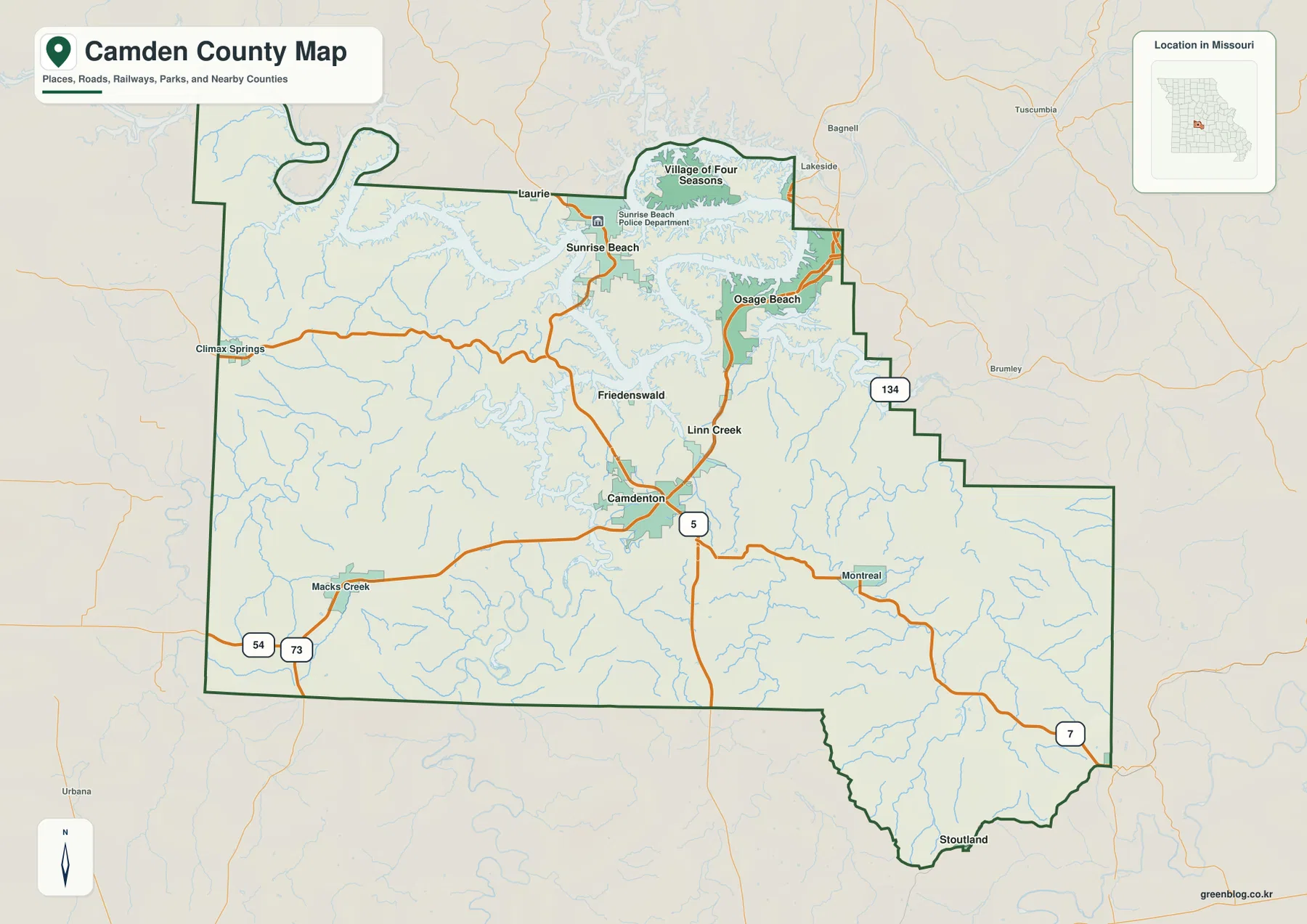
A simple way to use this map is to find Camdenton first and then move outward. Follow U.S. 54 west for Macks Creek, northeast for Linn Creek and Osage Beach, Route 5 north for Sunrise Beach, and the southern roads for Montreal or Stoutland. This approach keeps the complicated lake shoreline from becoming visually overwhelming and makes the county’s road structure much easier to understand.
Five of the six ranked communities cluster in the lake-and-Camdenton corridor
The city index map removes most road detail and emphasizes six selected communities. On the supplied map, Osage Beach ranks first with a displayed value of 4,905, Camdenton second at 4,023, the Village of Four Seasons third at 2,252, Sunrise Beach fourth at 413, Stoutland fifth at 243, and Linn Creek sixth at 188. These are the comparative values used by the map rather than a guarantee of the latest official population. Anyone who needs current population estimates or formal municipal statistics should verify them through the U.S. Census Bureau or the relevant local government.
The spatial pattern matters more than the ranking alone. Osage Beach, the Village of Four Seasons, and Sunrise Beach are closely tied to Lake of the Ozarks. Camdenton sits just south of the most intricate lake arms and connects them to the county’s inland road network. Linn Creek lies between Camdenton and the lake corridor to the northeast. Stoutland is the clear outlier, positioned far to the south near the county’s lower projection and separated from the northern community cluster by a large expanse of rugged interior terrain.
Osage Beach holds the largest value on this particular city index, but that does not make Camdenton less important as a geographic reference. Camdenton is the county seat and occupies a central road location where U.S. 54 and Route 5 provide useful orientation. The Village of Four Seasons, by contrast, is embedded among lake coves and peninsulas, and Sunrise Beach is associated with the western lake arms. Each community therefore stands out for a different reason: scale, government function, road access, or shoreline setting.
The numbered markers are rankings, not distance measurements. They do not show driving mileage or straight-line distance between cities. The map is best used to compare where the selected communities fall within Camden County: which ones cluster around the lake, which one sits near the center, and which one lies far south. For trip planning, the more detailed road map is the better choice because the lake’s coves and ridges can make apparently short connections much longer by road.
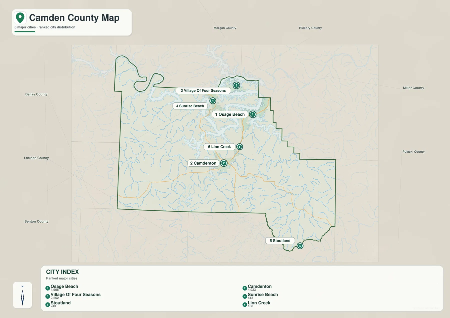
The surrounding county labels add context to the distribution. Morgan County is north of the lake area, Miller County lies to the northeast and east, Pulaski County is farther east, and Laclede and Dallas counties line much of the south and southwest. Hickory and Benton counties are to the west. Because Lake of the Ozarks spans a broader region than Camden County alone, administrative boundaries and the visual lake landscape do not always line up in an intuitive way.
Lake of the Ozarks coves merge with the Niangua and Little Niangua river valleys
The terrain-and-water map makes the northern landscape much easier to understand. Lake of the Ozarks fills a branching network of valleys, so the shoreline is made up of long coves, narrow fingers of land, and steeply cut side drainages rather than one broad open basin. Labels such as Johnsons Bay, Lick Branch Cove, Downing Branch Cove, Wideford Hollow Cove, Crabtree Cove, Shepherd Cove, and Libby Cove show how many named recesses occur within the larger lake system.
South and west of the main lake arms, the Niangua River and Little Niangua River form two of the most important drainage features. The Niangua River winds through the central-southern part of the county before joining the lake system, while the Little Niangua River drains the western side. Macks Creek is another prominent western stream. Their courses are not straight because they follow valleys cut into the Ozark uplands, and the shaded relief shows a dense pattern of smaller tributaries feeding the larger channels.
Eastern Camden County has its own network. Dry Auglaize Creek crosses a broad section of the east-central area, while Wet Glaize Creek forms a more southerly valley. Mill Creek and Deane Creek are also labeled on the eastern side. These streams show that the southern half of the county is not a single continuous ridge. It is a dissected landscape in which narrow valleys repeatedly separate higher hills and ridges.
The relationship between water and relief is especially visible near the lake. Blue water fills the lowest corridors, and gray terrain shading rises quickly on either side. In many places the land between neighboring coves is only a narrow ridge or peninsula. This has a practical consequence for reading the county map: water can separate communities that appear close in straight-line distance, while roads must follow the available ridges, bridges, and crossings. Looking at the general map and water map together helps explain the seemingly indirect road pattern.
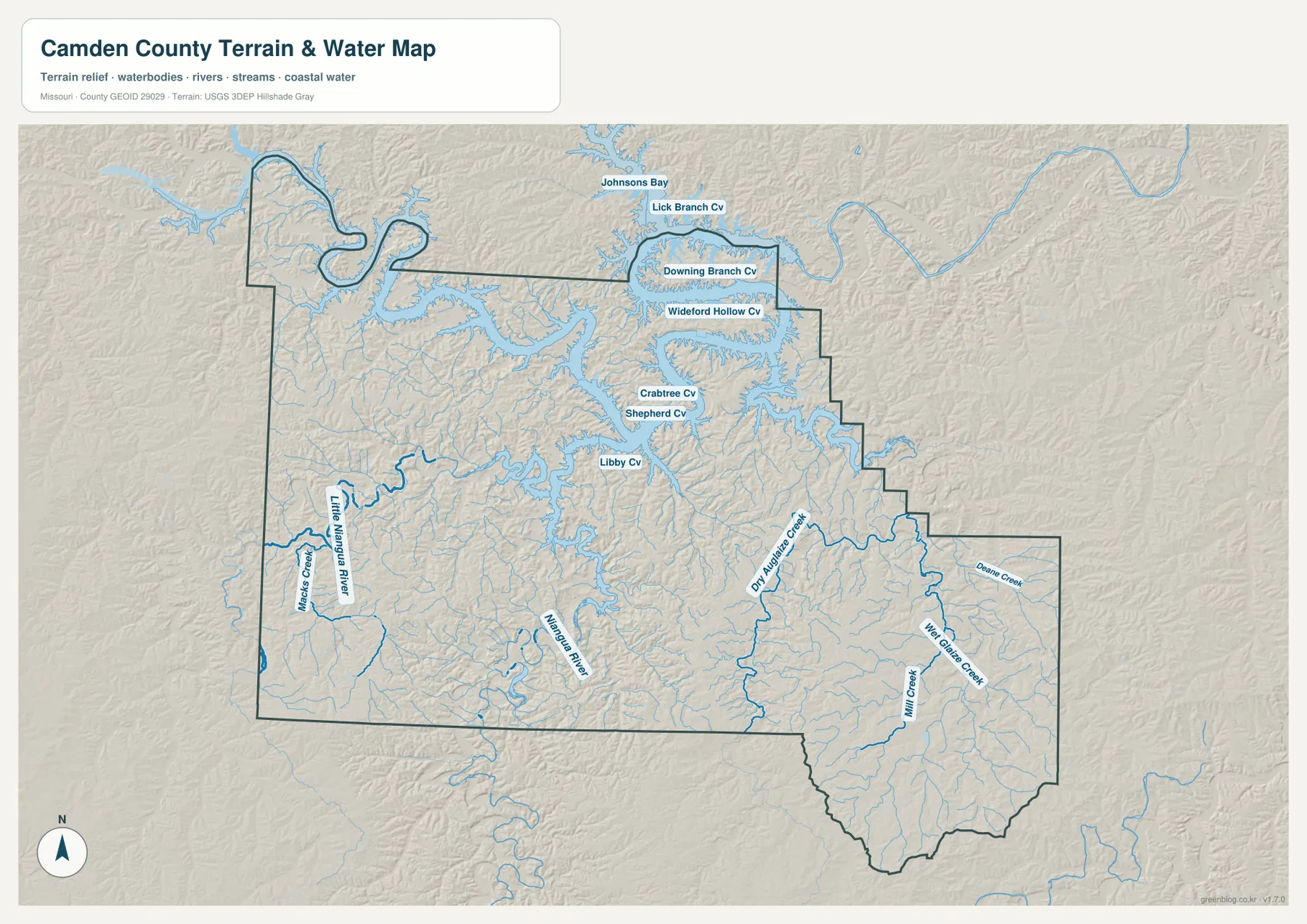
This water map is a general geographic reference, not a floodplain, parcel, legal-boundary, or navigation chart. A blue channel or a low valley on the map does not by itself identify a FEMA flood zone, navigable water, shoreline ownership, or current lake level. Decisions involving insurance, property boundaries, docks, development, boating restrictions, or real-time water conditions require the latest information from the appropriate public agency.
From roughly 200 to 381 meters, low lake corridors cut into higher Ozark ridges
The elevation map shows an actual county range of about 200 to 381 meters, with a mean near 265 meters. Greens represent lower ground within Camden County, while yellows, tans, and browns mark progressively higher terrain. The lake and major river valleys appear as branching green corridors, particularly across the north and through the Niangua drainage. Higher terrain is more extensive in parts of the southwest, south-central area, and southeast.
Northern Camden County is not simply low. The water occupies the lowest valley floors, but the narrow peninsulas between lake arms rise above them as a dense network of ridges. This produces a highly textured surface around Sunrise Beach, the Village of Four Seasons, and the broader Lake of the Ozarks shoreline. Camdenton also sits within rolling terrain rather than a broad flat plain, which helps explain the curving local road pattern beyond the main U.S. 54 corridor.
The southern half of the county contains larger patches of higher ground. Warm brown colors are prominent in the southwest and along the far southern and southeastern ridges, while green valleys cut between them. Around Stoutland and the southern projection, the relief becomes especially intricate. The result is a landscape where a short horizontal distance can cross several ridges and stream valleys, even though Camden County has no extremely high mountains by national standards.
Ha Ha Tonka State Park, just south of Camdenton, offers useful real-world context for this rugged terrain. Missouri State Parks describes caves, sinkholes, a natural bridge, bluffs, and a major spring there, all features associated with the karst landscape of the Ozarks. The county elevation map does not locate individual caves or sinkholes, but the steep and irregular relief around the southern lake country is consistent with the broader topographic setting visitors encounter in that area.
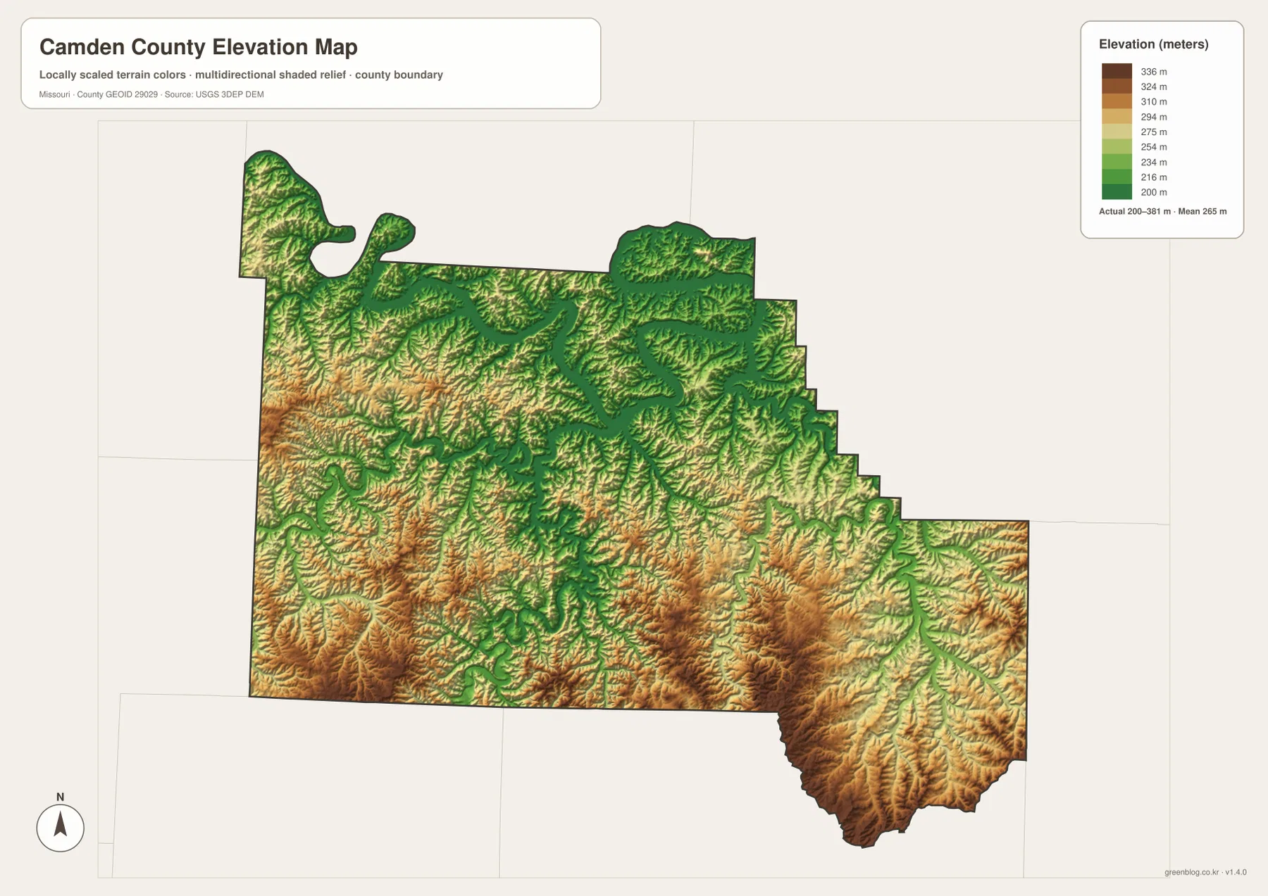
The color scale is locally stretched to make differences within Camden County easy to see. Brown does not mean the terrain is among the highest in Missouri, and green does not automatically indicate wetlands or flood hazard. This surface is appropriate for county-scale comparison. Surveying, engineering design, drainage calculations, or exact point elevations should use detailed USGS elevation products or professional field measurements.
Choose the map by whether you need roads, settlements, water, or relief
For general orientation, the county map is the most useful starting point. It combines the boundary, major communities, U.S. 54, Route 5, other state routes, and the broad shape of Lake of the Ozarks. Someone looking for the relationship between Camdenton, Osage Beach, Sunrise Beach, Macks Creek, and Stoutland will usually get the answer fastest from this version.
The city index is better when the goal is to compare the six selected communities without road clutter. It quickly shows that Osage Beach and Camdenton lead the displayed ranking, that the Village of Four Seasons and Sunrise Beach are strongly tied to lake country, and that Stoutland is geographically separate in the south. This simpler view works well for presentations, regional summaries, and quick settlement comparisons.
For physical geography, the terrain-and-water map provides the richest labels. It identifies the Niangua and Little Niangua rivers, major eastern creeks, and numerous lake coves while preserving shaded relief. The elevation map answers a different question: where the ground is relatively low or high. Viewed together, the two maps show why the Lake of the Ozarks shoreline is so intricate and why southern Camden County contains so many narrow stream valleys between higher ridges.
The WebP images embedded in the article are optimized for quick viewing online. The ZIP download contains four corresponding JPG originals at 3638 × 2572 pixels, which are better when you need to zoom into road labels, cove names, stream lines, or elevation shading, or when preparing a printed reference. These maps remain general-purpose geographic resources rather than substitutes for parcel surveys, legal boundaries, flood insurance maps, real-time navigation, or engineering data.
In short, Camden County is easiest to understand as a meeting place between lake country and rugged interior Ozark terrain. Lake of the Ozarks dominates the north, Camdenton anchors the road network, Osage Beach and other communities cluster around water, and the Niangua system cuts through the hills to the south and west. Starting with those relationships makes the county’s unusual boundary and complicated road pattern much easier to interpret.
Frequently Asked Questions
Why is Camden County’s northern boundary so much more irregular than its southern side?
Lake of the Ozarks fills a dense network of valleys across northern Camden County, creating long coves, narrow peninsulas, and repeated bends between land and water. The county boundary also turns around this complicated lake-country geography, so it has many more angles and indentations than several straighter southern and western segments. Comparing the county map with the terrain-and-water map makes the connection especially clear.
If Osage Beach ranks first on the city map, why is Camdenton used as the main reference point?
Osage Beach has the largest value on the supplied six-city index, but Camdenton is the county seat and occupies a central road position on U.S. 54 near Route 5. That makes Camdenton especially useful for explaining directions across the county. The two maps emphasize different things: the city index compares selected community size, while the general map highlights the road and geographic framework.
Does the green lowland around Lake of the Ozarks on the elevation map represent a flood zone?
No. Green indicates relatively lower elevation within Camden County, not a FEMA flood classification. Lake shores, river valleys, and creek corridors often appear lower, but actual flood risk depends on water levels, rainfall, detailed terrain, infrastructure, and official flood mapping. Insurance, development, and property decisions should use current FEMA and local government information.
Map File Information
The ZIP contains the four high-resolution JPG originals used for the county map, ranked city distribution map, terrain-and-water map, and elevation map. They are larger than the web-optimized WebP images and are useful for zooming into road labels, lake coves, stream names, and relief details or for preparing a printed reference.
- File Type: JPG
Related Maps
Sources and References
- Camden County Missouri official website: official county location, government, and local information.
- Missouri State Parks – Ha Ha Tonka State Park: official information on karst features, bluffs, caves, springs, and the landscape south of Camdenton.
- U.S. Census Bureau TIGER/Line Shapefiles: authoritative county boundary and geographic reference data.
- USGS National Hydrography: authoritative river, stream, lake, and hydrographic reference data.
- USGS 3D Elevation Program: authoritative elevation and terrain surface data.
Green Map creates custom-edited map images using open geographic data sources such as geoBoundaries, Natural Earth, OpenStreetMap, and government open data. These maps are edited visual materials, not raw data files, and are provided for education, documents, presentations, and graphic reference.