Le Sueur County in south-central Minnesota combines a low western Minnesota River valley with rolling higher terrain toward the east and northeast. The city of Le Sueur sits close to the river side, Le Center occupies the interior, Montgomery is farther east, and Waterville and Elysian lie within a lake-rich southeastern district. Comparing the four supplied views makes those differences much clearer than roads alone.
This page uses the supplied county, city, water, and elevation maps to explain the actual communities, highways, rivers, lakes, and relief shown in the package. Original high-resolution JPG versions are also available together in one ZIP download for printing, classroom work, presentations, or image editing.
Table of Contents
Roads connect the Le Sueur river side with Le Center and Montgomery
The city of Le Sueur is the easiest place to begin on the general county map. U.S. 169 follows the western river corridor near the city, while Highway 19 crosses the upper part of the county. Kasota and Cleveland provide additional references farther south along the western side.
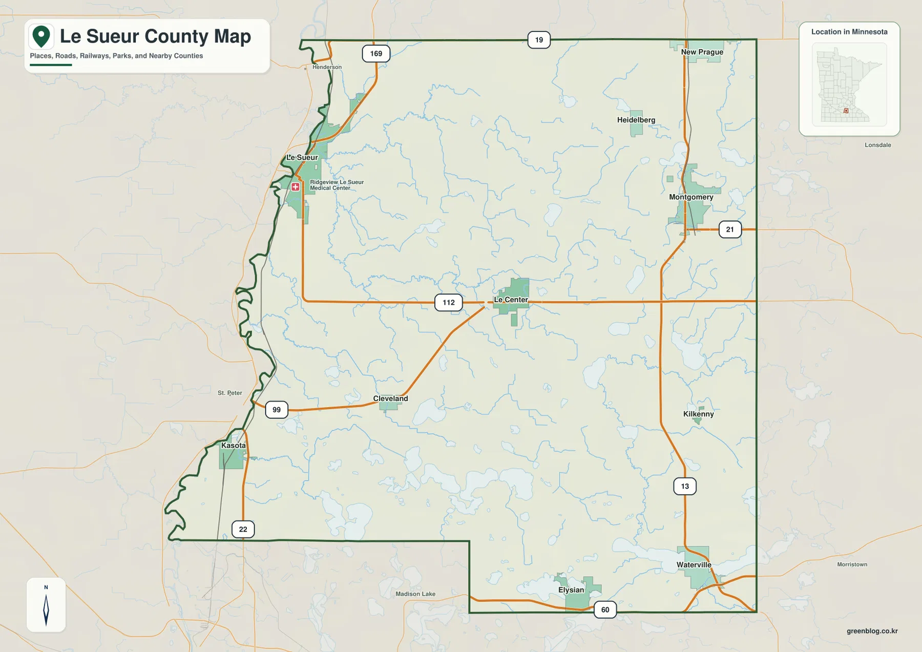
Le Center sits near the middle of the county close to the east-west road labeled 112 on the supplied map. Montgomery lies farther east along Highway 13, which continues south toward Waterville. Highway 21 appears near the eastern boundary and provides another north-south reference toward Rice County.
Highways 99 and 22 help locate Cleveland and Kasota in the southwest. Farther south, Highway 60 crosses near Elysian and the county’s southern edge. Roads in the southeastern lake district bend around water bodies more often than routes in the open central interior.
New Prague appears near the northeastern edge, with Heidelberg and Montgomery farther south. The county is therefore easier to understand as three broad settings: the western river valley, the rolling central interior, and the more lake-rich southeast. The general map is for orientation rather than live traffic, construction, or winter-road conditions.
Six selected cities span the river valley, interior, and lake district
The city map highlights Le Sueur, Montgomery, Le Center, Waterville, Elysian, and Cleveland. Le Sueur is on the western side, Montgomery is in the east, Le Center is central, and Waterville and Elysian occupy the southeast. Cleveland provides a southwestern reference near the Minnesota River side.
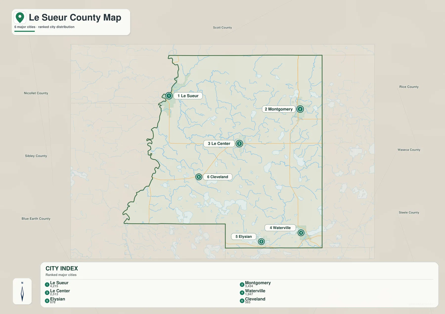
The supplied CITY INDEX lists Le Sueur at 4,215, Le Center at 2,513, Montgomery at 2,344, Waterville at 1,947, Elysian at 676, and Cleveland at 563. These should be treated as values embedded in the map rather than as a claim about the latest official population estimates. They are most useful for comparing the selected communities.
Le Sueur is represented as the largest of the six, but Le Center is the county seat. The official county website places the Le Sueur County Government Center at 88 South Park Avenue in Le Center. The largest mapped community and the administrative center therefore serve different geographic roles.
Montgomery and Waterville provide the strongest eastern and southeastern references. Montgomery is useful for following Highway 13, while Waterville sits beside the Cannon River and Lake Tetonka system. Elysian and Cleveland are smaller but help define the southern and southwestern sides of the county.
The Minnesota River creates a low western edge
The western boundary follows the broad Minnesota River valley, and that relationship is visible in both the water and elevation maps. The boundary bends repeatedly along the river side, while the Le Sueur and Kasota areas occupy terrain much lower than the eastern uplands.
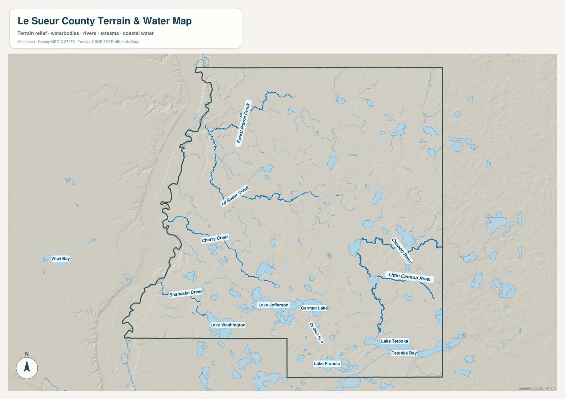
Forest Prairie Creek, Le Sueur Creek, Cherry Creek, and Shanaska Creek drain different parts of the central and western county toward the low river side. Le Sueur Creek is especially prominent through the middle, while Cherry Creek and Shanaska Creek occupy separate lower corridors farther south.
Le Sueur County’s official GIS services include parcels, road centerlines, and drainage-related layers. Those sources are better suited to parcel-level or administrative questions, while the map on this page is intended to show the larger county-wide relationship among waterways, roads, and settlements.
Cannon River and Lake Tetonka define the southeastern lake country
The eastern and southeastern water map is dominated by Cannon River and Little Cannon River. Both pass through the broader Montgomery-Waterville side, where Lake Tetonka and Tetonka Bay add large open-water features. Waterville therefore appears much more closely tied to water than it does on the road-only view.
Lake Jefferson, German Lake, Lake Washington, and Lake Francis provide additional southern landmarks. Lake Jefferson and German Lake sit relatively close together in the south-central interior, Lake Washington is farther southwest, and Lake Francis lies nearer the southeastern edge.
Minnesota DNR’s Le Sueur-Rice County public water access map identifies Tetonka, Jefferson, Washington, and other local lakes as separate public-water resources. That official map is a useful companion when access points matter, while the map here is intended for broader geographic comparison.
This water map should not be used as a flood, depth, navigation, fishing-regulation, or legal-access map. Current DNR and county information is the appropriate source for those decisions.
A 218–362 meter rise from the river valley to eastern uplands
The supplied elevation map reports an actual range of about 218 to 362 meters, with a mean near 308 meters. Dark green low terrain forms a narrow western strip along the Minnesota River, while yellow and brown become increasingly common toward the center, east, and northeast. The east-west contrast is one of the county’s clearest physical features.
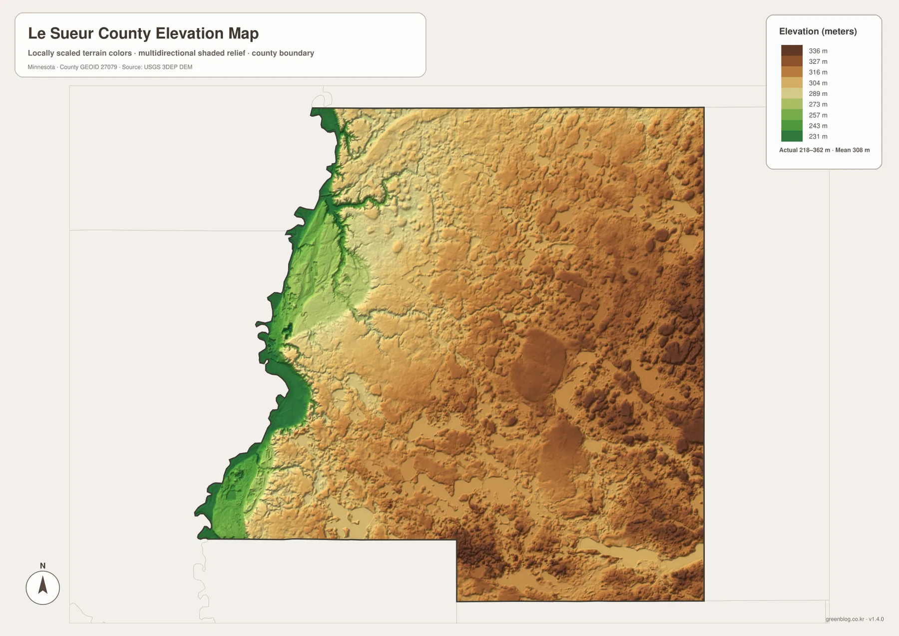
The western lowland is narrow but very distinct around Le Sueur and Kasota. Small tributary valleys extend eastward from it, allowing Forest Prairie Creek and Le Sueur Creek to be matched with lower green corridors on the relief map. In several places, elevation rises quickly just east of the river edge.
The central interior is higher than the river valley but far from flat. Rolling hills and shallow depressions repeat around Le Center, and the southern lake district contains additional low basins around Lake Jefferson, German Lake, and Lake Washington.
The east and northeast contain the broadest high terrain. The Montgomery and New Prague sides are much higher than the Minnesota River valley, while Cannon River and Little Cannon River occupy lower corridors cutting through the uplands. The county can therefore be read as a low western river edge rising into a rolling eastern interior.
This elevation surface is useful for county-scale comparison, not surveying or engineering. It should not be used for exact building elevations, road grades, drainage design, or parcel-level contour decisions. Detailed USGS 3D Elevation Program data or professional survey information are better sources when precision matters.
Le Sueur, Le Center, and Waterville occupy different physical settings
Le Sueur sits closest to the low Minnesota River valley. U.S. 169 follows the same western corridor, and terrain rises east of the city. That makes Le Sueur a useful reference for understanding the county’s lowest landscape, even though it is the largest selected community on the city map.
Le Center occupies the rolling middle of the county between the river valley and eastern uplands. Small streams and lakes remain common, but the landscape is less dominated by a single major river or lake. Its central location and county-government role make it a useful reference for the interior.
Waterville and Elysian sit in a much more water-rich southeastern setting. Cannon River, Little Cannon River, Lake Tetonka, and several nearby lakes shape local road and settlement patterns. Comparing the city and water maps makes the difference between this lake district and the western river-valley setting especially clear.
Choosing a map for roads, towns, water, or relief
Use the general county map when Le Sueur, Le Center, Montgomery, Waterville, Elysian, Cleveland, and the major numbered roads need to appear together. The city map is cleaner when the goal is to compare the six selected communities and their CITY INDEX values.
The water map is the better choice for the Minnesota River side, Le Sueur Creek, Cannon River, Little Cannon River, Lake Tetonka, Jefferson, Washington, and other lakes. Pair it with the elevation view when the goal is to explain the low western river valley and higher eastern uplands.
For printing or image editing, the original JPG files in the ZIP provide more resolution than the WebP previews embedded in this article. Each JPG measures 3638 by 2572 pixels, and the archive contains the county, city, water, and elevation maps.
Official county GIS, DNR, and federal reference sources
The official Le Sueur County website provides land records, planning and zoning, tax, drainage, and other government services from the Government Center in Le Center. The county GIS server also publishes parcel, road-centerline, and drainage-related layers for more detailed local work.
Minnesota DNR’s Le Sueur-Rice County public water access map is useful for local lakes such as Tetonka, Jefferson, and Washington. U.S. Census Bureau TIGER/Line supports boundary and road work, USGS National Hydrography provides water data, and the USGS 3D Elevation Program provides detailed elevation products.
Frequently Asked Questions
Is Le Sueur or Le Center the county seat?
Le Center is the county seat. The official Le Sueur County website lists the Government Center in Le Center. Le Sueur is represented as the largest selected city in the supplied CITY INDEX, so city size and county-government function are centered in different places.
Which major waters are near Waterville?
Waterville is close to Cannon River, Little Cannon River, Lake Tetonka, and Tetonka Bay. Lake Jefferson, German Lake, Lake Washington, and Lake Francis provide additional southern lake references.
Where are the lowest and highest parts of Le Sueur County?
The supplied elevation map shows a range of about 218–362 meters with a mean near 308 meters. The Minnesota River valley along the west is lowest, while the east and northeast are substantially higher. Exact site elevations require detailed USGS or survey data.
Map File Information
Download the original high-resolution JPG versions of the Le Sueur County maps shown on this page in one ZIP file.
- Included Files: county map, city map, water map, elevation map
- Printable Size: each JPG is 3638 × 2572 px
- File Type: ZIP containing 4 JPG files
Related Maps
Sources and references
- Le Sueur County official website – Government Center, land records, taxes, planning, zoning, and county services
- Le Sueur County GIS – official parcel, road-centerline, drainage, and other GIS layers
- Minnesota DNR Le Sueur & Rice County Water Access Map – local lakes and public water-access references
- U.S. Census Bureau TIGER/Line Shapefiles – boundary, road, and place data
- USGS National Hydrography – river, stream, and water data
- USGS 3D Elevation Program – elevation data and products
Green Map creates custom-edited map images using open geographic data sources such as geoBoundaries, Natural Earth, OpenStreetMap, and government open data. These maps are edited visual materials, not raw data files, and are provided for education, documents, presentations, and graphic reference.