Dodge County is an inland county in southeastern Minnesota where the central communities of Dodge Center and Kasson provide an easy reference point for the rest of the map. Mantorville sits just northeast of Kasson, West Concord is farther northwest, Claremont is near the western side, and Hayfield is well to the south. This page explains the county boundary, road network, city distribution, streams, and terrain shown in the supplied maps, and the high-resolution JPG versions can be downloaded for printing or reuse. High-resolution map files are available for download in the section below.
Two features make the county especially easy to read. Highway 14 crosses the central part of the county through Dodge Center and Kasson, while the northern half contains a dense network of Zumbro River branches and smaller creeks. South of that network, the Little Cedar River and East Fork Cedar River appear near the lower part of the county. Comparing the road, water, and elevation views shows how the communities sit among broad uplands and lower stream valleys rather than on a completely uniform surface.
Table of Contents
Dodge Center and Kasson along the central road corridor
The general county map gives the broadest overview because it places communities, numbered roads, streams, and the county outline in a single frame. Dodge Center lies close to the geographic middle of the county, and Kasson is positioned to the east along the same main east-west route. Several other numbered roads meet or cross this central corridor, including 56 and 148 near Dodge Center and 34 and 15 near Kasson. Mantorville is a short distance northeast of Kasson, so the eastern-central part of the map contains the county’s tightest cluster of named communities.
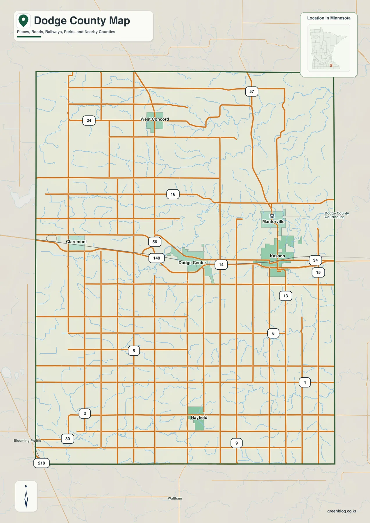
Away from that central cluster, the settlement pattern becomes more dispersed. West Concord is in the northwest near road 24, Claremont is close to the western side, and Hayfield occupies a separate position in the southern part of the county. Road 57 descends through the northeast, while 30 and several local routes cross the southern area. The many straight local roads visible between the larger routes reflect the rural grid, making it possible to follow how farms and smaller settlements connect back to the main towns without treating the map as a turn-by-turn navigation product.
The map also provides useful edge references. Blooming Prairie is labeled just beyond the southwest corner, Waltham appears south of the county, and the eastern side leads toward Olmsted County. These outside labels help orient the county within southeastern Minnesota and make the boundary easier to interpret when the map is used in a report, classroom handout, or local history project. For detailed driving instructions, current road conditions, or construction detours, a live transportation source should still be used in addition to this static reference map.
How the six mapped cities are distributed
The city-focused map removes much of the road detail and emphasizes six communities. Its printed city index ranks Kasson first, Dodge Center second, Hayfield third, Mantorville fourth, West Concord fifth, and Claremont sixth. The values shown with those labels are 7,050 for Kasson, 2,880 for Dodge Center, 1,395 for Hayfield, 1,047 for Mantorville, 843 for West Concord, and 502 for Claremont. Because the map does not state a separate reference year beside that index, those figures are best treated as values printed on this map rather than as a substitute for a current population table.
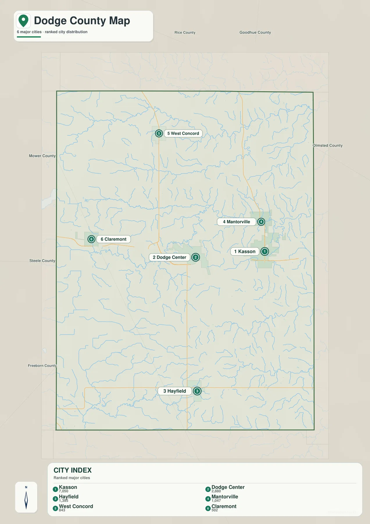
The spatial arrangement matters more than the ranking alone. Kasson and Dodge Center form the most obvious central pair, with Mantorville nearby to the northeast. Hayfield is much farther south, West Concord is isolated toward the northwest, and Claremont sits along the western side. That spread makes the map useful when a reader needs a quick answer to questions such as whether two communities are in the same part of the county or which direction to look from the central Highway 14 corridor.
Neighboring county labels add another layer of context. Rice and Goodhue counties are shown to the north, Olmsted County to the east, Mower and Freeborn counties to the south or southeast, and Steele County to the west. This is helpful for regional comparisons because Dodge County is small enough that nearby communities and county boundaries can matter when discussing schools, services, commuting, or local history. The city map is not designed to calculate road mileage, so actual travel distance should be checked with a routing source when that information matters.
Middle Fork Zumbro River across the northern half
The water map makes clear that Dodge County is defined more by streams and river branches than by large lakes. The Middle Fork Zumbro River runs across the northern part of the county and receives numerous small tributaries from both sides. Farther south, the South Branch Middle Fork Zumbro River follows another long east-west course through the central half. Smaller named features, including Milliken Creek and Dodge Center Creek, appear among a much denser network of thin tributary lines that are difficult to notice on the general road map.
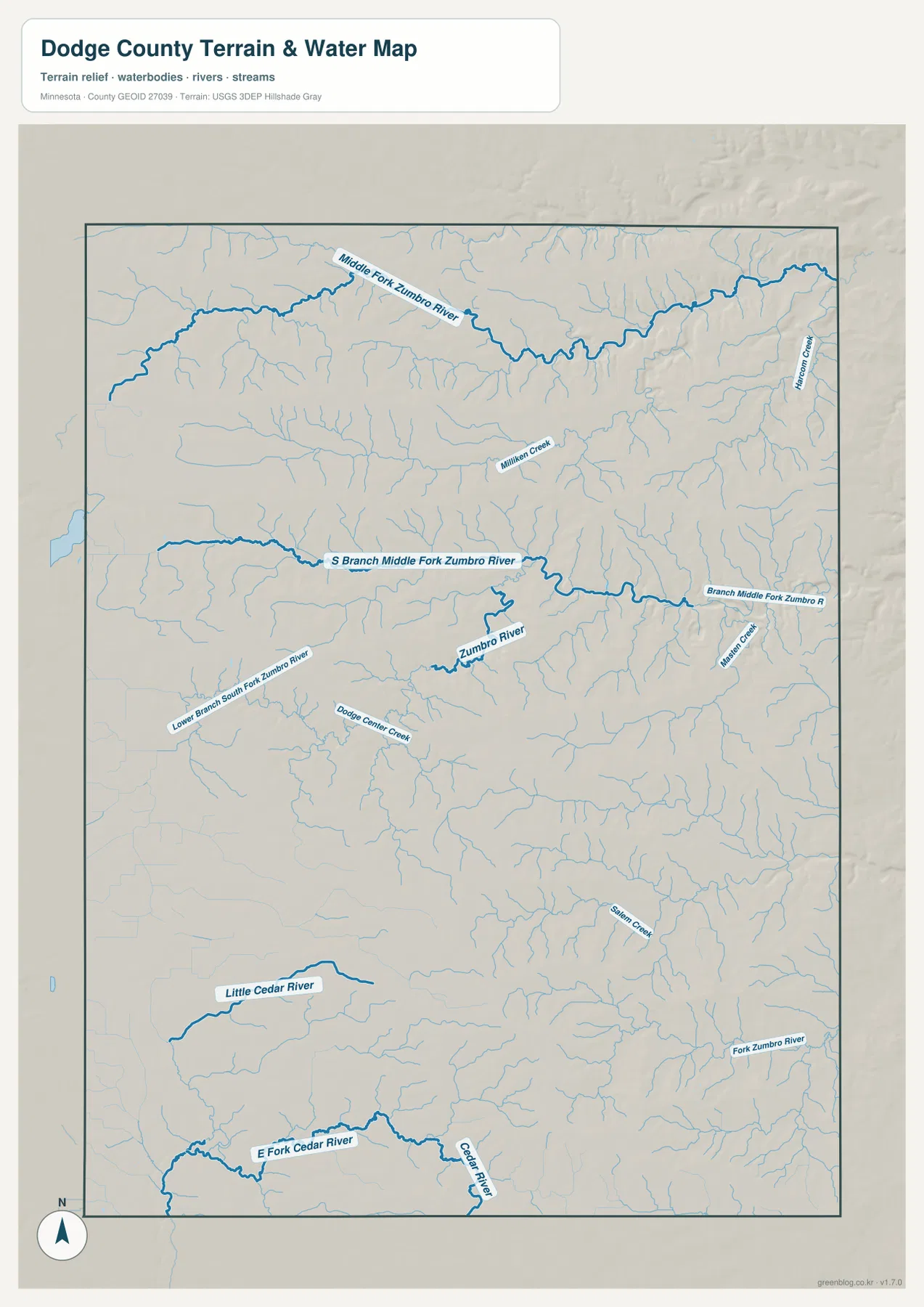
The central water network is not a single uninterrupted channel. The map shows branches of the Zumbro system, short creeks, and many unnamed tributaries converging at different points. A Lower Branch South Fork Zumbro River label appears west of the middle of the county, while additional Zumbro-related channels continue toward the east. This level of detail is useful for identifying the nearest named stream or understanding how a local creek connects to a larger river system, but it should not be interpreted as a flood map, parcel boundary map, or navigation chart.
Little Cedar and East Fork Cedar rivers in the south
The southern third of Dodge County looks different from the northern Zumbro-dominated area. The Little Cedar River is labeled in the southwest, and the East Fork Cedar River reaches the southern edge along with the Cedar River. Salem Creek and many smaller tributaries fill the space between those larger named channels. The result is a county where the northern and southern sections connect to different prominent river names, a distinction that is easy to miss when roads and city labels are the main focus.
Comparing the water map with the city map helps connect natural and human geography. Dodge Center sits near smaller creeks in the central portion, while Kasson and Mantorville are surrounded by numerous tributaries leading toward the eastern side. Hayfield is farther from the prominent northern Zumbro branches and closer to the southern network. These relationships are appropriate for general geographic explanation, but anyone planning field access, drainage work, or land management should consult current hydrologic and property records rather than relying only on this overview.
Elevation from 308 to 420 meters
The elevation map reports an actual range of about 308 to 420 meters, with a mean near 382 meters. Broad areas in the south-central and western parts of the county appear in tan and brown tones, indicating relatively higher ground. Lower green areas are more common in the northeast and along stream-cut corridors on the eastern side. Dodge County does not contain dramatic mountain relief, yet the shaded surface shows enough variation to separate rolling uplands from the valleys carved by the river network.
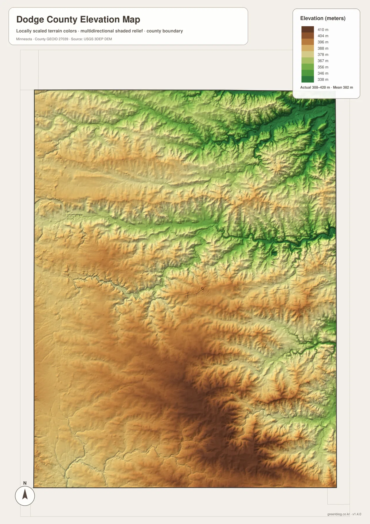
The northeast is the clearest example of the connection between water and relief. Branching green valleys on the elevation map line up with the dense tributary pattern visible on the water map, while higher tones occupy the ground between those channels. Similar but smaller incisions continue through the central and southern portions. The pattern is therefore more complex than a simple north-low, south-high slope: individual streams create narrow lower corridors within otherwise higher terrain.
This elevation surface is intended for county-scale comparison rather than engineering measurement. The colors and shaded relief are useful for showing where the land is generally higher or lower, but they should not be used to determine the exact elevation of a parcel, design a structure, or calculate site drainage. For those purposes, the underlying elevation data and professional survey information are more appropriate. In a classroom or presentation, however, pairing this map with the water map is an effective way to show why river branches often follow the lower parts of the landscape.
Choosing the most useful map for the task
The general county map is the best choice when boundaries, communities, and numbered roads need to appear together. The city map is cleaner for showing where the six highlighted communities sit relative to one another. For river names, creeks, and tributary connections, the water map contains far more detail, while the elevation map is the clearest option for comparing uplands with lower valleys. Using two maps together can be more informative than forcing every feature into one crowded view.
For example, a local history page about Dodge Center and Kasson may only need the general and city maps. A geography lesson about the Zumbro River branches benefits from the water and elevation views side by side because the stream network can be compared directly with lower terrain. The downloadable archive contains the original 2572 × 3638 pixel JPG versions, while the WebP images in the article are convenient previews for screen viewing.
Frequently Asked Questions
What is the easiest way to locate Dodge Center and Kasson?
Start with Highway 14 across the middle of the county. Dodge Center is on the western side of the central pair and Kasson is to the east, with Mantorville a short distance northeast of Kasson. The general county map is the most useful version when you want the road numbers and city locations together.
How do the northern and southern river systems differ?
The Middle Fork Zumbro River and South Branch Middle Fork Zumbro River dominate the northern and central portions of the water map. In the south, the Little Cedar River and East Fork Cedar River become more prominent. Numerous smaller tributaries connect to these larger channels throughout the county.
Can the elevation map be used as survey data?
No. It is a county-scale visualization showing a broad elevation range of roughly 308 to 420 meters and the contrast between lower valleys and higher ground. It works well for general geography and educational use, but parcel-level engineering, construction, or drainage decisions require original elevation data and professional survey information.
Map File Information
The ZIP contains the original high-resolution JPG versions of the four Dodge County maps described on this page.
- Included Files: county map, city map, water map, elevation map
- Printable Size: 2572 × 3638 px for each JPG
- File Type: ZIP containing 4 JPG images
Related Maps
Sources and reference data
For more detailed source material, the U.S. Census Bureau TIGER/Line Shapefiles provide boundary and road data, USGS National Hydrography covers rivers and streams, and the USGS 3D Elevation Program provides elevation data. These official resources are the better choice when a project requires current source files, precise geographic analysis, or verification beyond the county-scale maps presented here.
Green Map creates custom-edited map images using open geographic data sources such as geoBoundaries, Natural Earth, OpenStreetMap, and government open data. These maps are edited visual materials, not raw data files, and are provided for education, documents, presentations, and graphic reference.