Cook County occupies the northeastern tip of Minnesota, where a long Lake Superior shoreline borders a large interior filled with lakes, streams, forest roads, and higher ground. Grand Marais is the clearest population center on the maps, while Lutsen lies to the southwest and Grand Portage is near the narrow northeastern end. Looking at the shore and interior together is the easiest way to understand why travel and settlement are concentrated in only part of this large county.
This page includes separate views for county roads and places, the ranked city location, water features, and elevation. The maps can be viewed on the page, and the matching A3 high-resolution JPG files are also available together in a downloadable ZIP archive. A useful way to read the set is to begin with Highway 61 along Lake Superior, then compare what happens to roads, rivers, lakes, and terrain as you move inland.
Table of Contents
Highway 61 links Cook County’s Lake Superior communities
The general county map makes the shoreline the main point of orientation. Cook County is broad across the west and northwest, then narrows as it extends toward Grand Portage and the international border. Lake Superior forms the county’s long southeastern edge, while the inland boundary encloses a much larger area with fewer roads. This shape helps explain why the county can feel linear when traveling even though its interior covers a wide expanse.
Minnesota Highway 61 enters from the southwest, passes Lutsen and Grand Marais, and continues northeast toward Grand Portage and the Canadian border. Local routes branch inland at several points, with labels such as 14, 16, 20, 70, 89, 152, 154, 158, and 309 visible on the map. Around Grand Marais, several of those routes gather near the shore before spreading northward, whereas road coverage becomes noticeably thinner farther west and north.
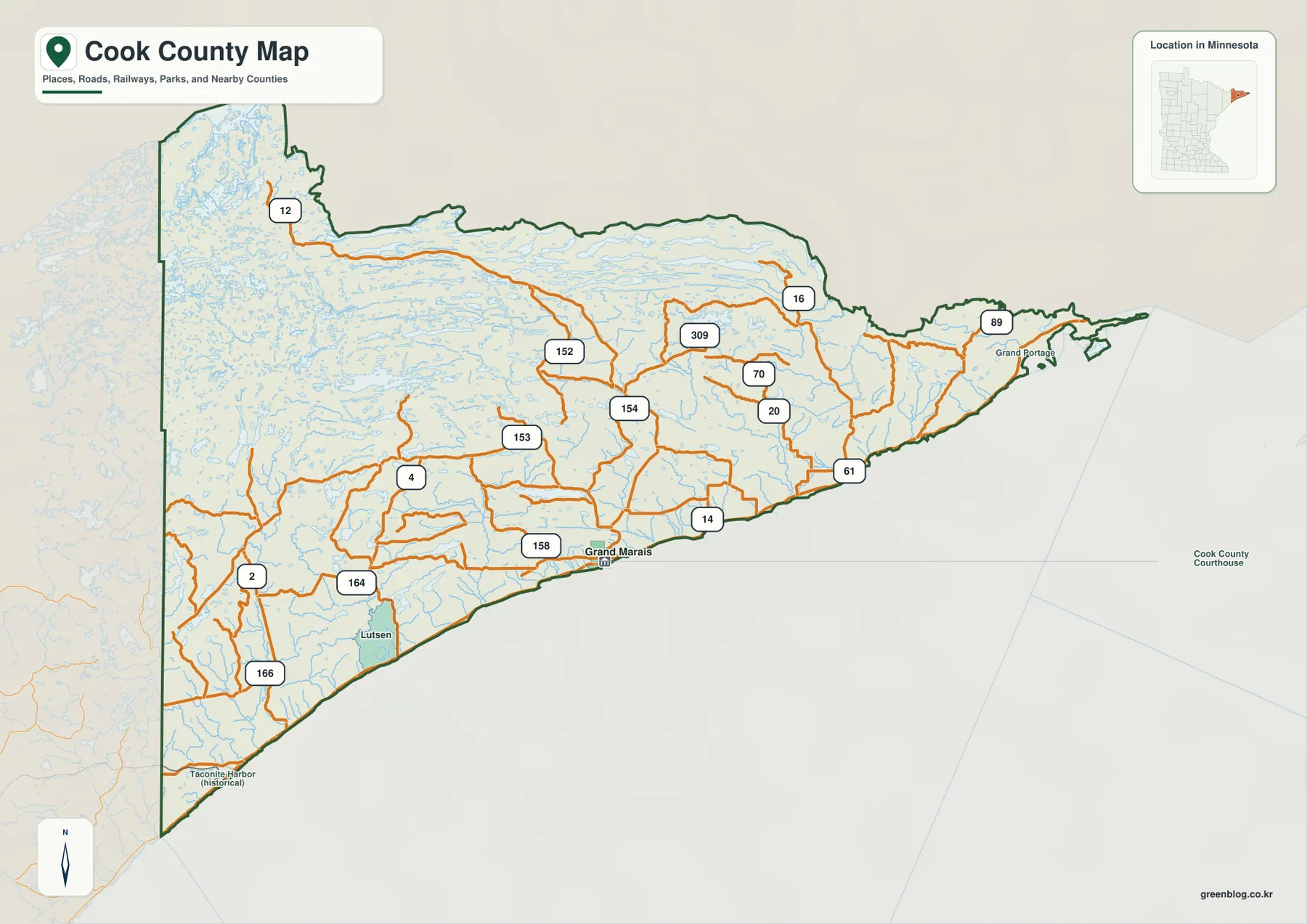
Grand Marais sits on the lakeshore east of the county’s midpoint and is the most obvious road junction shown. Lutsen is farther southwest along Highway 61, and Grand Portage occupies the far northeastern side. The National Park Service describes Grand Portage in the context of Minnesota’s Arrowhead and the north shore of Lake Superior, close to the international boundary. That setting is useful background for the unusual shape at the county’s northeastern tip.
Use this map for orientation rather than turn-by-turn driving. It is good for comparing where communities sit, which roads leave the lakeshore, and how much of the county lies away from the main highway. Current detours, construction, winter closures, and exact route conditions should be checked with Cook County and the Minnesota Department of Transportation, because those details can change after a static map is made.
Grand Marais stands alone on the ranked city map
The city map strips away most road labels and highlights a single ranked place: Grand Marais. The CITY INDEX shows Grand Marais with a value of 1,796, and there are no city-to-city connector lines because no second ranked city appears in this particular graphic. The result is a clean view of where Grand Marais sits along the Lake Superior side of the county, roughly opposite the broad undeveloped interior.
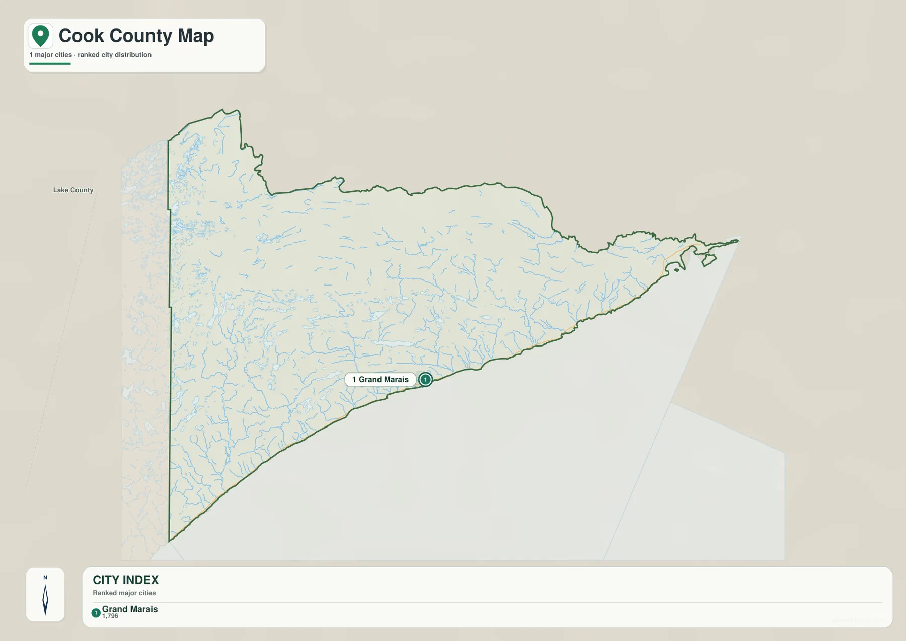
A one-city map should not be read as a list of every community in Cook County. Lutsen, Tofte, Schroeder, Hovland, Grand Portage, and other local places remain important for travel and local life, but they are outside the ranking used for this graphic. If you need those names, the general county map is the better reference. If you need a presentation slide that quickly locates the county seat area, the city map is more effective because it removes most competing detail.
The sparse city display also makes sense in the context of the county’s population and land area. U.S. Census Bureau QuickFacts lists an estimated Cook County population of 5,522 on July 1, 2025. With extensive forest, lakes, public lands, and relatively limited development, settlement is not spread evenly across the county. The map therefore works best as a simple location view rather than as a complete inventory of inhabited places.
Inland lakes feed rivers flowing toward Lake Superior
The terrain and water map changes the emphasis from roads to water. In the northwest, Mud Bay, Gulf Lake, and Sea Gull Lake are prominent, with Cross Bay Lake and Brule Lake farther southeast. Pine Lake appears near the northern interior, and many smaller lakes and streams fill the spaces between the labeled features. The amount of blue across the interior immediately distinguishes Cook County from counties where agriculture or a dense road grid dominates the landscape.
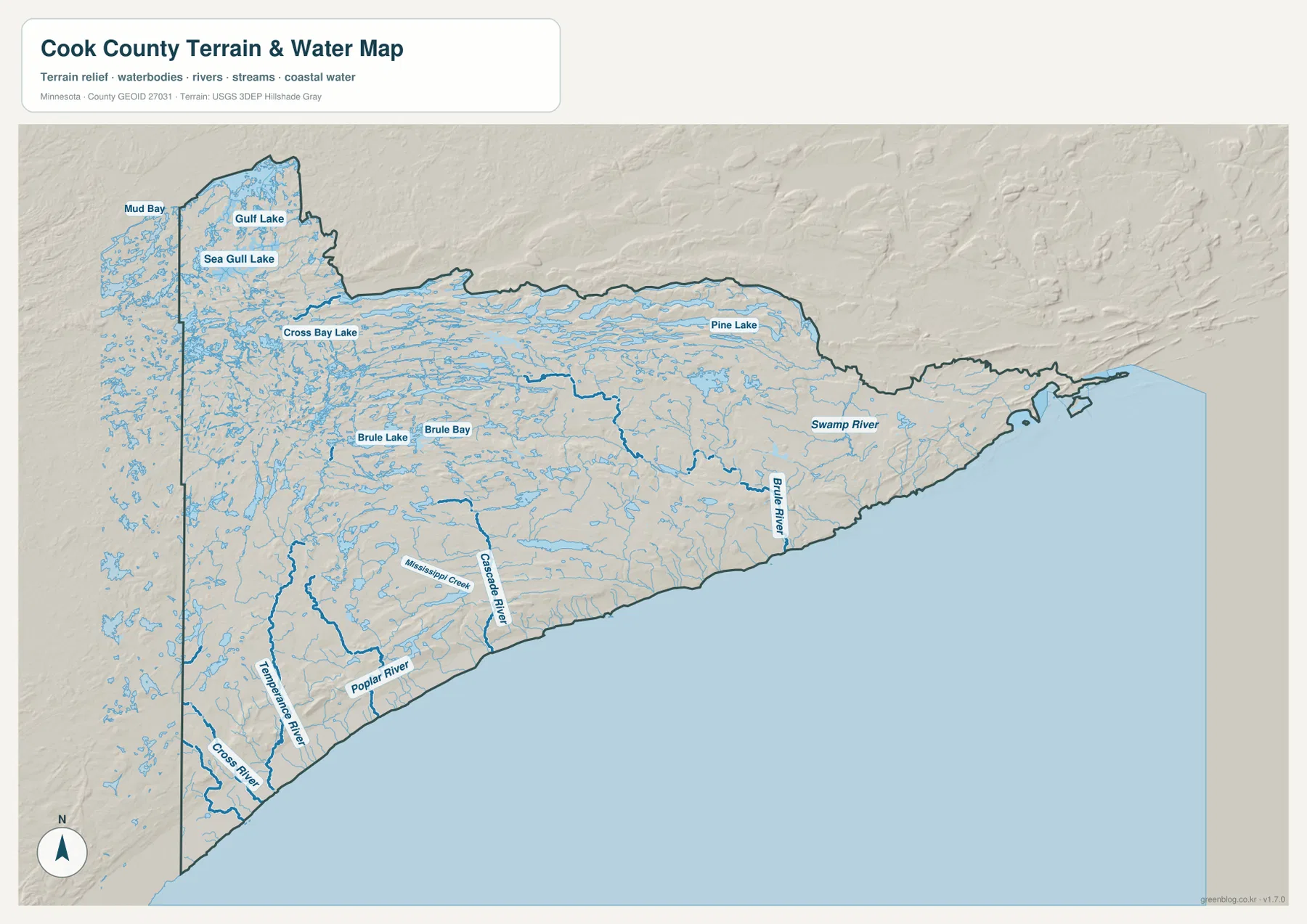
Several named rivers can be followed from the interior toward Lake Superior. From southwest toward the northeast, the map labels Cross River, Temperance River, Poplar River, Cascade River, Brule River, and Swamp River. Their lower courses reach the same shoreline followed by Highway 61, so the road crosses or approaches a succession of drainage valleys. Comparing this map with the road map is especially useful for understanding why waterfalls, river mouths, and steep ravines are recurring features along the North Shore corridor.
The concentration of lakes in the northwestern part of the county belongs to a much larger forest-and-water setting. The U.S. Forest Service describes Superior National Forest as a landscape of extensive forests, lakes, and rocky terrain and notes that the Boundary Waters Canoe Area Wilderness lies within the forest. The map on this page does not draw those management boundaries, so it should not be used to decide whether a campsite, portage, or lake lies inside a permit area.
This is also not a flood map, navigation chart, wetland determination, or parcel record. A blue line or polygon is useful for locating a river or lake at county scale, but it does not establish safe boating routes, public access, flood-insurance status, shoreline ownership, or regulatory jurisdiction. Those questions require current information from Cook County, Minnesota agencies, the U.S. Forest Service, or other responsible authorities.
Elevation rises quickly away from the Lake Superior shore
The elevation map shows one of Cook County’s strongest physical contrasts. Its legend reports an actual range of about 182 to 694 meters and a mean near 496 meters. The lowest colors form a narrow strip along Lake Superior, while higher greens, tans, and browns spread inland. Much of the central and western interior is substantially higher than the shore, producing the broad upland appearance that is difficult to appreciate from the road map alone.
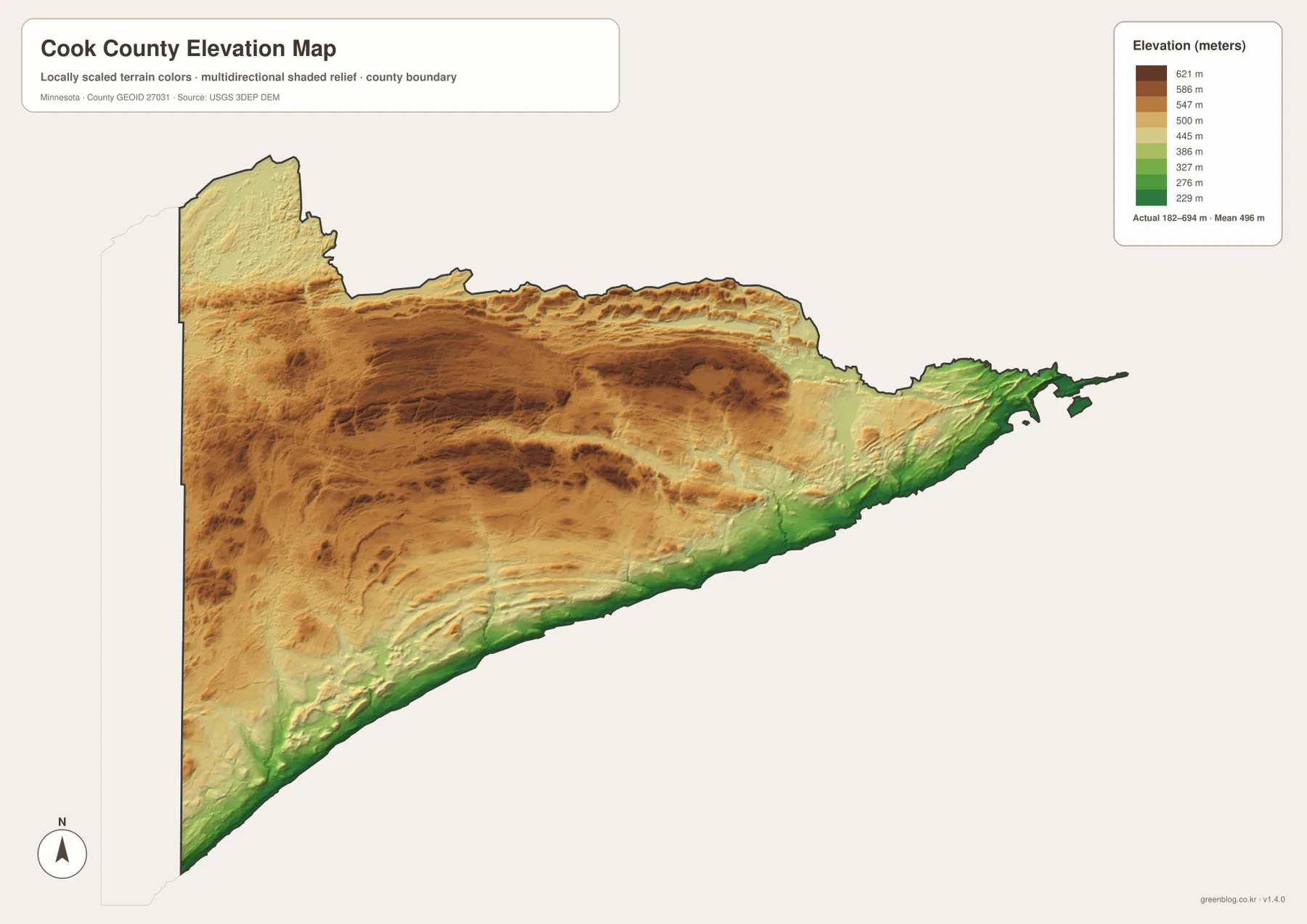
Near Grand Marais and Lutsen, the map shows the low lakeshore giving way to higher ridges over a relatively short distance. That rise helps explain the direction of the rivers on the water map: Temperance, Poplar, Cascade, Brule, and other streams begin or gather on higher ground and descend toward Lake Superior. Valleys cut through the uplands, so the interior is not a flat plateau even where broad areas share similar elevation colors.
The northeastern end near Grand Portage contains more low and middle elevation colors than some of the central uplands, while the west and southwest include long bands of higher terrain. Local relief varies around lakes, valleys, and ridges, so the 182–694 meter range is only a county-wide summary. It should not be treated as the elevation of any specific road, building site, shoreline parcel, or trail location.
For engineering, grading, drainage design, or surveying, use higher-resolution elevation products and appropriate field measurements. The USGS 3D Elevation Program is a better starting point for technical work. The map here serves a different purpose: it makes the broad rise from Lake Superior into the interior easy to see and provides a useful visual companion to the river map.
Which Cook County map fits the task?
Choose the general county map when road connections and named places matter. It is the best starting point for tracing Highway 61 from the western county line through Lutsen and Grand Marais toward Grand Portage, and it also shows where local roads turn inland. Choose the ranked city map when Grand Marais is the only place you need to emphasize, such as on a simple classroom slide or a county overview.
The water map is more useful for questions about Sea Gull Lake, Brule Lake, or the rivers reaching Lake Superior. It can also explain why a trip along Highway 61 repeatedly encounters river valleys. Add the elevation map when the subject includes the steep rise away from the shore, the higher interior, or the relationship between uplands and river courses. Each view removes some details and emphasizes others, so using them together is often more informative than forcing every topic onto one map.
Cook County contains many recreation sites, protected lands, trails, campgrounds, and historic places that are not labeled on these maps. Grand Portage National Monument provides detailed material for the northeastern historical landscape, while Superior National Forest publishes current information for a much larger network of forest lands, lakes, roads, and wilderness areas. Use the county maps to understand the broad location first, then consult the relevant agency before a trip that depends on permits, access rules, trail status, or seasonal conditions.
For official geographic data, U.S. Census Bureau TIGER/Line files are useful for boundaries and transportation layers, USGS National Hydrography provides water information, and USGS 3DEP provides elevation products. Cook County’s own website is the better place to begin for local administrative and property-related mapping. The downloadable images on this page are intended for readable county-scale reference and do not replace those authoritative records.
Frequently Asked Questions
Why is Grand Marais the only ranked city shown?
This city graphic uses a ranked-city index rather than a complete list of communities. Grand Marais is the only Cook County place included in that index, so it receives the sole city marker. Lutsen, Tofte, Schroeder, Hovland, Grand Portage, and other communities still matter locally; use the general county map when you need those places and the roads that connect them.
Which map makes the rivers flowing to Lake Superior easiest to see?
Use the terrain and water map. It labels Cross River, Temperance River, Poplar River, Cascade River, Brule River, Swamp River, and several inland lakes, making their relationship to Lake Superior easy to compare. If you also need Highway 61 and local road numbers, place the general county map beside it.
Can the 182–694 meter range be used for site-level elevation work?
No. That range describes the county-wide elevation shown by the map and is not a precise measurement for a parcel, building site, trail, or road segment. Surveying, engineering, grading, and drainage work require higher-resolution official elevation data and, where appropriate, field measurements. Use this map for broad terrain comparison rather than site design.
Map File Information
The ZIP archive contains the original high-resolution JPG versions of all four Cook County maps shown on this page.
- Included Files: county map, city map, terrain and water map, elevation map
- File Type: ZIP containing 4 JPG images
Related Maps
Sources and references
- Cook County, Minnesota official website – county services, roads, mapping, and administrative information
- U.S. Census Bureau QuickFacts: Cook County, Minnesota – population and county statistics
- Minnesota Department of Transportation – Highway 61 and county route information
- U.S. Forest Service: Superior National Forest – forest, lakes, and Boundary Waters context
- National Park Service: Grand Portage National Monument – Grand Portage history and northeastern Lake Superior setting
- U.S. Census Bureau TIGER/Line Shapefiles – geographic boundaries and transportation data
- USGS National Hydrography – river and water data
- USGS 3D Elevation Program – elevation data and products
Green Map creates custom-edited map images using open geographic data sources such as geoBoundaries, Natural Earth, OpenStreetMap, and government open data. These maps are edited visual materials, not raw data files, and are provided for education, documents, presentations, and graphic reference.