Washington County occupies Maine’s far eastern edge, stretching from the Machias area along a deeply indented coast to Calais, Eastport, Lubec, and the long northern interior near Vanceboro. Its eastern side meets New Brunswick, while the south and southeast open toward the Gulf of Maine and the Atlantic. The supplied maps make that geography easy to compare: roads and communities on one view, the two ranked cities on another, and a dense network of rivers, bays, and coastal water on the terrain-water map. High-resolution JPG versions of the map files can also be downloaded together in a ZIP archive.
Machias is the Washington County seat and also works as a practical landmark on the road map. From there, U.S. 1 and several state routes lead toward the eastern border communities, while Routes 9 and 6 help organize the much larger inland section. Farther east, Calais sits close to the international boundary, Eastport occupies a water-fringed coastal position, and Lubec lies still farther south along the Atlantic side. The contrast between these compact coastal destinations and the sparsely labeled northern interior is one of the strongest features of the county map.
Table of Contents
U.S. 1 ties Machias to a coast that becomes increasingly intricate toward Calais
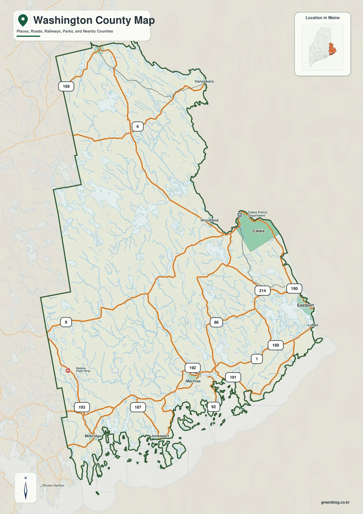
Machias is the simplest place to begin reading the general county map. U.S. 1 passes through the southern part of Washington County and continues northeast, while Routes 191 and 192 branch through the surrounding area. Route 193 reaches toward the southwestern side of the county, and Route 187 turns toward the Jonesport area. Together these roads show why Machias functions as more than a single town marker: it is a useful junction for understanding how the county’s southern road system divides between the coast and the interior.
Following U.S. 1 northeast introduces a different pattern. Route 86 crosses the central area, and Route 214 appears closer to the Calais-Eastport side. As the road approaches the eastern boundary, it threads between rivers, narrow land sections, and coastal inlets instead of crossing a broad uninterrupted plain. The curves become easier to understand when the road map is compared with the water map, where the bays and river mouths occupying this part of the county are much more obvious.
Calais is the strongest northeastern road reference, while Eastport lies farther south and is reached from the U.S. 1 side by Route 190. Lubec sits farther down the Atlantic coast, with Route 189 providing the most visible connection on the supplied map. These places may look close in a small county overview, but the shoreline between them is split by bays, channels, and projecting land. Their actual road relationship is therefore more complicated than a simple straight coastal line.
Southwest of Machias, the map labels Milbridge and Jonesport among a maze of small coastal projections and islands. Route 187 is the clearest numbered reference near Jonesport, while Route 193 reaches toward the western boundary. On a small screen, it is easier to locate Machias first and then move toward one named coastal community at a time than to follow every orange road line at once. The high-resolution JPG is especially useful when those smaller route labels matter.
Route 9 and Route 6 reveal how large the northern interior really is
The coastal communities receive most of the visible place labels, but the northern and western parts of Washington County cover a much larger space. Route 9 enters from the west and runs across the interior toward the Woodland-Calais side. Around it, the map shows extensive water networks and relatively few large settlement labels. That open appearance is a useful reminder that a county known for its coast also contains a broad inland landscape where long road segments connect widely separated places.
Route 6 provides another strong organizing line, running through the north-central part of the county toward Vanceboro. The farther north the map goes, the less useful coastal place names become for orientation. Route 6 and Vanceboro offer a better frame, with numerous lakes and narrow waterways filling the background. Instead of trying to identify every stream, readers can use the highway as the first landmark and then add nearby water features as needed.
Route 169 appears near the northwestern edge, while Route 9 remains the main east-west reference across the central-western portion. Comparing this area with the U.S. 1 corridor makes the internal contrast clear. The coast contains many named communities and short connecting roads; the interior has broader spaces, longer route segments, and a landscape visually dominated by water and undeveloped terrain. That difference matters when planning how much detail to show on a printout or classroom map.
The map is intended for geographic orientation rather than live navigation. Winter weather, construction, road restrictions, and detours can change, especially across long rural stretches. Drivers should verify current MaineDOT information and use a navigation service before traveling. A county overview is most useful for seeing the direction and relationship of routes, not for predicting travel time from map distance alone.
The City Index places Calais and Eastport on two distinct parts of the eastern edge
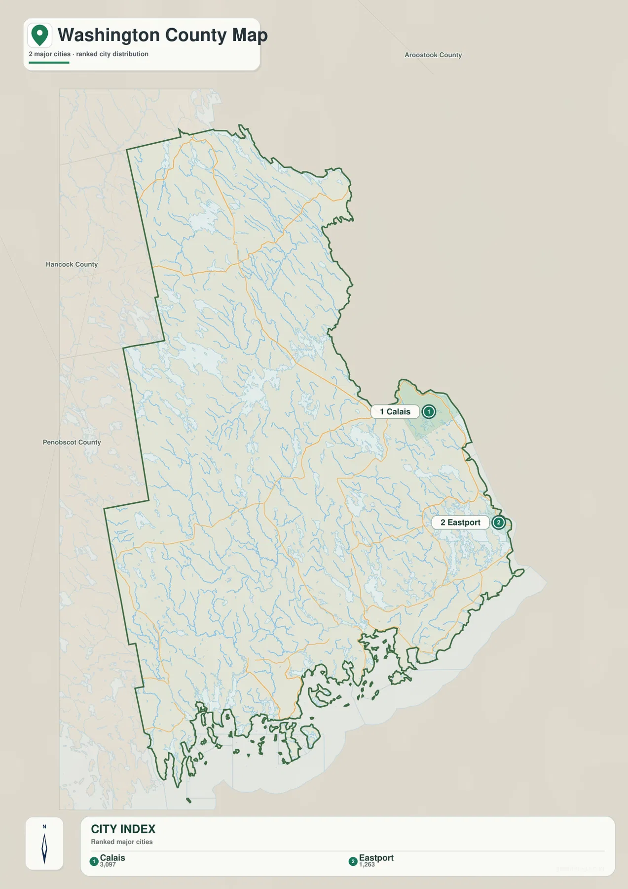
The City Index ranks only two locations: Calais in the first position with the figure 3,097 and Eastport in the second position with 1,263. The graphic does not provide a year or a statistical definition for those numbers, so they should not be presented as current population estimates. Anyone who needs up-to-date population data should consult the latest U.S. Census Bureau tables rather than treating the index values as current.
The most useful information in this simplified view is geographic. Calais appears near the international boundary in the northeastern part of the county, while Eastport lies farther south along a water-fringed section of the coast. With most road labels removed, the two markers make it easy to see that the ranked cities are concentrated on the eastern side rather than around Machias, the western interior, or the long northern section.
No straight-line distance or connector line is shown between Calais and Eastport. The City Index therefore should not be used to estimate driving mileage or travel time. For actual route context, return to the general map and look at U.S. 1, Route 190, and the surrounding state roads, then confirm a trip with current navigation data.
Machias being the county seat does not require it to appear in this ranked city graphic. The index is a simplified major-city layer rather than an administrative-center map. Machias, Lubec, Milbridge, Jonesport, Woodland, and Vanceboro remain important geographic references on the general county map, while the City Index is best used when a clean comparison of Calais and Eastport is all that is needed.
The Machias and Dennys river systems break the interior into many smaller watersheds
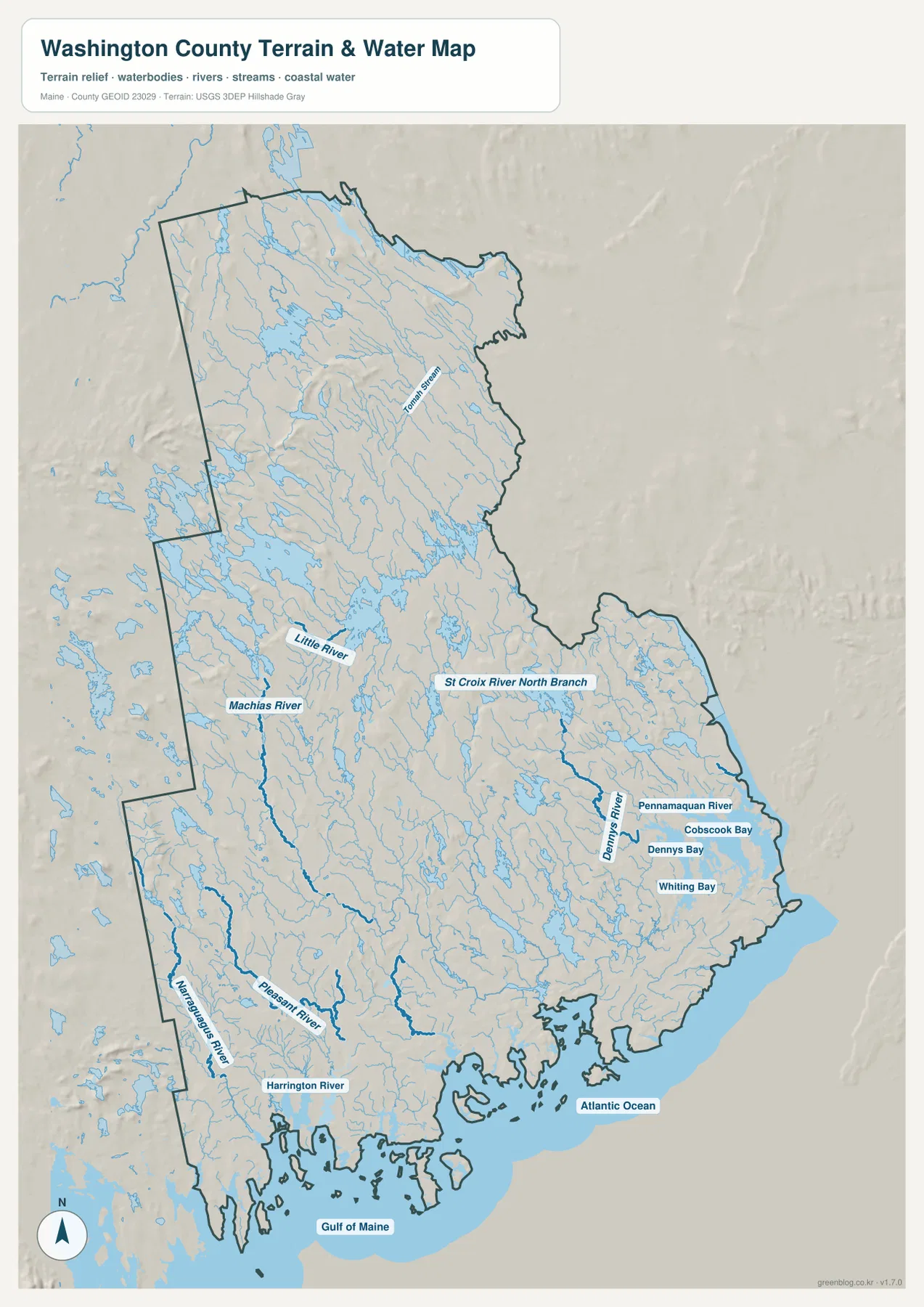
The terrain-water map shows a county that is far more water-rich than the road map first suggests. The Machias River runs through the central-southwestern side with many tributaries feeding it, while Tomah Stream is labeled much farther north. East of the county’s center, the St Croix River North Branch appears among an extensive pattern of lakes and narrow channels. Large areas that seem nearly empty on the road map are actually filled with connected freshwater features.
The Dennys River provides an important eastern reference. Near it, the Pennamaquan River reaches toward the same coastal region, and the shoreline opens into Dennys Bay, Cobscook Bay, and Whiting Bay. Comparing this view with the road map helps explain the curves and indirect connections around the Calais-Eastport-Lubec side. The roads are navigating a landscape divided by estuaries and narrow arms of water rather than a simple continuous coast.
Farther southwest, the Narraguagus River descends near the county’s western edge, while the Pleasant River and Harrington River reach the coast in separate drainage systems. This part of Washington County does not funnel into one dominant river. Several independent watersheds sit close together before meeting the Gulf of Maine, which is why the shoreline around Milbridge, Jonesport, and nearby islands looks so fragmented on the map.
The shaded-relief background adds a sense of hills and valleys, but it is not a survey-grade elevation surface. It can help readers see where streams occupy lower ground and where rolling terrain surrounds them, yet it does not provide precise elevation or slope measurements. Engineering, surveying, site planning, and other technical work should use authoritative elevation data such as the USGS 3D Elevation Program rather than measurements inferred from this illustration.
Cobscook Bay and the Lubec coast create the county’s most intricate shoreline
Cobscook Bay is one of the clearest labels on the eastern water map. The Dennys and Pennamaquan river systems approach the same general area, with Dennys Bay and Whiting Bay appearing farther south. Land and water interlock repeatedly here, creating narrow peninsulas, channels, and inlets. That geometry explains why Eastport and Lubec cannot be understood as two points on a smooth coastal road even though they occupy the same broad eastern side of the county.
South of the Lubec area, the map labels the Atlantic Ocean, while the lower southwestern coast is marked by the Gulf of Maine. Between these larger water bodies and the mainland are many islands and narrow passages. The Jonesport-Milbridge side is especially irregular, reinforcing the idea that Washington County’s southern boundary is shaped as much by coastal water as by any simple land line.
This terrain-water map is not a nautical chart, flood map, legal water-boundary survey, or source of depth information. It does not show tides, navigation channels, shoals, real-time river levels, flood probabilities, or parcel ownership. Boating, emergency planning, coastal regulation, and flood decisions require current products from agencies such as NOAA, FEMA, USGS, and the State of Maine. The map here is a geographic overview of relative water and terrain locations.
On a small screen, it is better to start with a few large labels rather than attempt to read every stream. Cobscook Bay, the Machias River, and the Dennys River are strong eastern and southern landmarks. Tomah Stream and the St Croix River North Branch help orient the north, while the Narraguagus, Pleasant, and Harrington rivers organize the southwestern side. Once those anchors are clear, the smaller waterways become much easier to place.
Choose the road map for routes and the water map for the county’s coastal shape
The general county map is the strongest choice for questions about Machias, Calais, Eastport, Lubec, Route 9, Route 6, or U.S. 1. It keeps community names, roads, and the full county outline in one view, making it easier to understand how a destination relates to the rest of Washington County. Because the county is both long and broad, starting with the full outline before zooming into a town usually saves time.
The City Index is useful when the goal is a clean visual comparison of Calais and Eastport without the distraction of smaller roads and towns. The terrain-water map serves a different need: it makes the Machias River, Dennys River, Cobscook Bay, and other water features much more prominent. Switching between the road and water views often explains why routes bend, why communities cluster near particular shores, and why the eastern coastline looks unusually complex.
The downloadable originals are JPG files measuring 2572 × 3638 pixels each. That size works well for full-page documents or for zooming into a specific part of the county in presentations and classroom material. Enlarging the image does not add live traffic, precise elevation, nautical detail, or flood data, so specialized decisions should always be checked against current official sources.
Washington County benefits from using more than one map style because its geography changes sharply from the inland north to the coastal southeast. The road map is best for travel orientation, the city view isolates the ranked urban points, and the terrain-water map explains the rivers and bays that shape the boundary. Selecting the map that matches the question keeps the information useful without overloading the page.
Frequently Asked Questions
How should Machias and Calais be used as reference points on the Washington County map?
Machias is the county seat and a useful southern road anchor, while Calais provides a strong reference on the eastern international-boundary side near U.S. 1 and Route 9. The map is good for understanding direction and relative position, but current driving routes and travel times should be checked with a navigation service and MaineDOT information.
Are the Calais 3,097 and Eastport 1,263 figures on the City Index current populations?
They should not be treated as current population figures because the supplied graphic does not state a reference year or statistical definition. This article treats them only as values printed on the City Index. Use the latest U.S. Census Bureau data when a current population estimate or count is required.
Can the Cobscook Bay and Dennys Bay map be used for boating or flood-risk decisions?
No. The terrain-water image is a general geographic reference. It does not provide water depth, tides, navigation channels, shoals, flood zones, real-time water levels, or legal boundaries. Use current NOAA, FEMA, USGS, and State of Maine products when safety, navigation, regulation, or flood risk is involved.
Map File Information
The ZIP archive contains three high-resolution JPG maps of Washington County matching the map themes described on this page.
- Included Files: county and major roads map, City Index map, terrain and water map
- Printable Size: 2572 × 3638 pixels each
- File Type: JPG
Related Maps
Sources and References
- Washington County, Maine – Official Website
- Washington County Unorganized Territories – About
- U.S. Census Bureau – TIGER/Line Shapefiles
- USGS – National Hydrography
- USGS – 3D Elevation Program
Green Map creates custom-edited map images using open geographic data sources such as geoBoundaries, Natural Earth, OpenStreetMap, and government open data. These maps are edited visual materials, not raw data files, and are provided for education, documents, presentations, and graphic reference.