Trigg County occupies a distinctive part of southwestern Kentucky, where Cadiz anchors the inland road network while Lake Barkley and the Cumberland River shape much of the county’s western side. This Trigg County Kentucky Map collection shows Cadiz, Cerulean, US 68/80, KY 139, the Little River drainage, broad lake water, and rolling relief that ranges from about 107 to 246 meters. The web maps are useful for quick reference, and all four original high-resolution JPG files can also be downloaded together in a ZIP archive. High-resolution map files are available for download in the section below.
The county’s official website describes Trigg County as part of Kentucky’s southwestern Pennyrile, bordering Tennessee to the south and lying beside Lake Barkley. That description matches the supplied maps well. Cadiz sits inland toward the northeastern half of the county, while the west is broken into long shorelines, bays, narrow ridges, and river valleys. The road map alone emphasizes connections between communities, but the water and elevation maps explain why the western half feels so different from the broader inland country around Cadiz.
Table of Contents
Cadiz ties together US 68/80, KY 139, and the interior road network
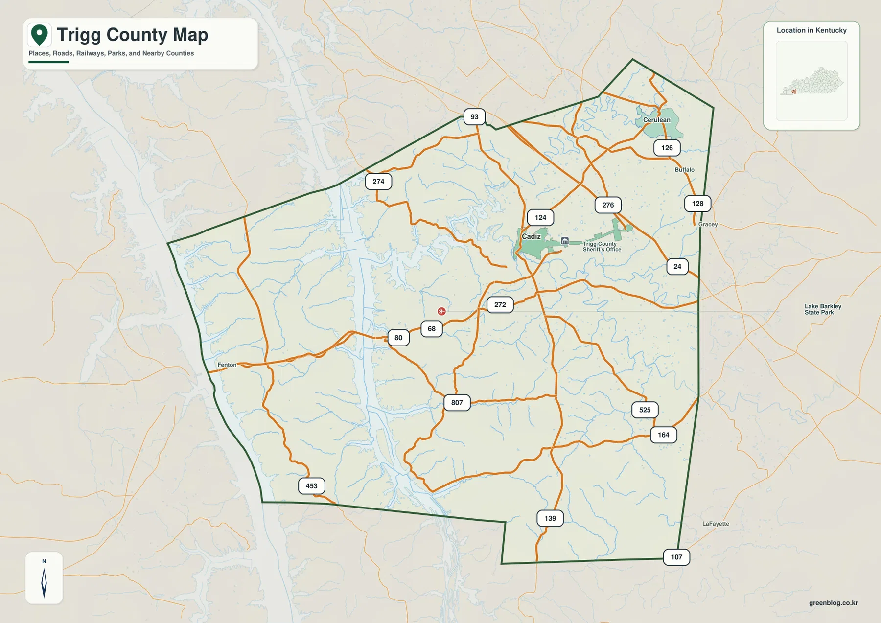
Cadiz is the clearest orientation point on the county map. US 68/80 crosses the county from the west toward Cadiz, while KY 124, KY 276, KY 272, and a network of smaller roads spread outward from the surrounding area. KY 139 runs south from the Cadiz region toward the Tennessee line, making it an especially useful north–south reference. Farther southeast, KY 525, KY 164, and KY 107 appear near the county edge, while KY 93 and KY 274 help organize the northern side.
The northeastern corner has another recognizable cluster around Cerulean, where KY 126 and KY 128 are labeled. Fenton appears on the western side near the more heavily indented lake country. Those places help show that Trigg County is not simply a single-town county with empty space around Cadiz. The road network has several local branches, but Cadiz remains the point where the most visible east–west and north–south routes come together.
West of Cadiz, the road pattern begins to respond more strongly to water. Long arms of Lake Barkley and the Cumberland River system cut into the county, leaving ridges and peninsulas between narrow valleys. Roads curve around those features rather than forming a simple grid. Following US 68/80 westward is a useful way to see the transition: the inland road web around Cadiz gives way to a landscape where shorelines and channels increasingly influence the shape of travel routes.
This map is a geographic reference rather than a live navigation product. It does not show current traffic, closures, construction, access restrictions, or private property boundaries. Its strength is the ability to compare the county outline, principal numbered roads, communities, and nearby place names in one view. For route planning, a current transportation source should be used alongside it.
A single major-city marker keeps Cadiz easy to locate
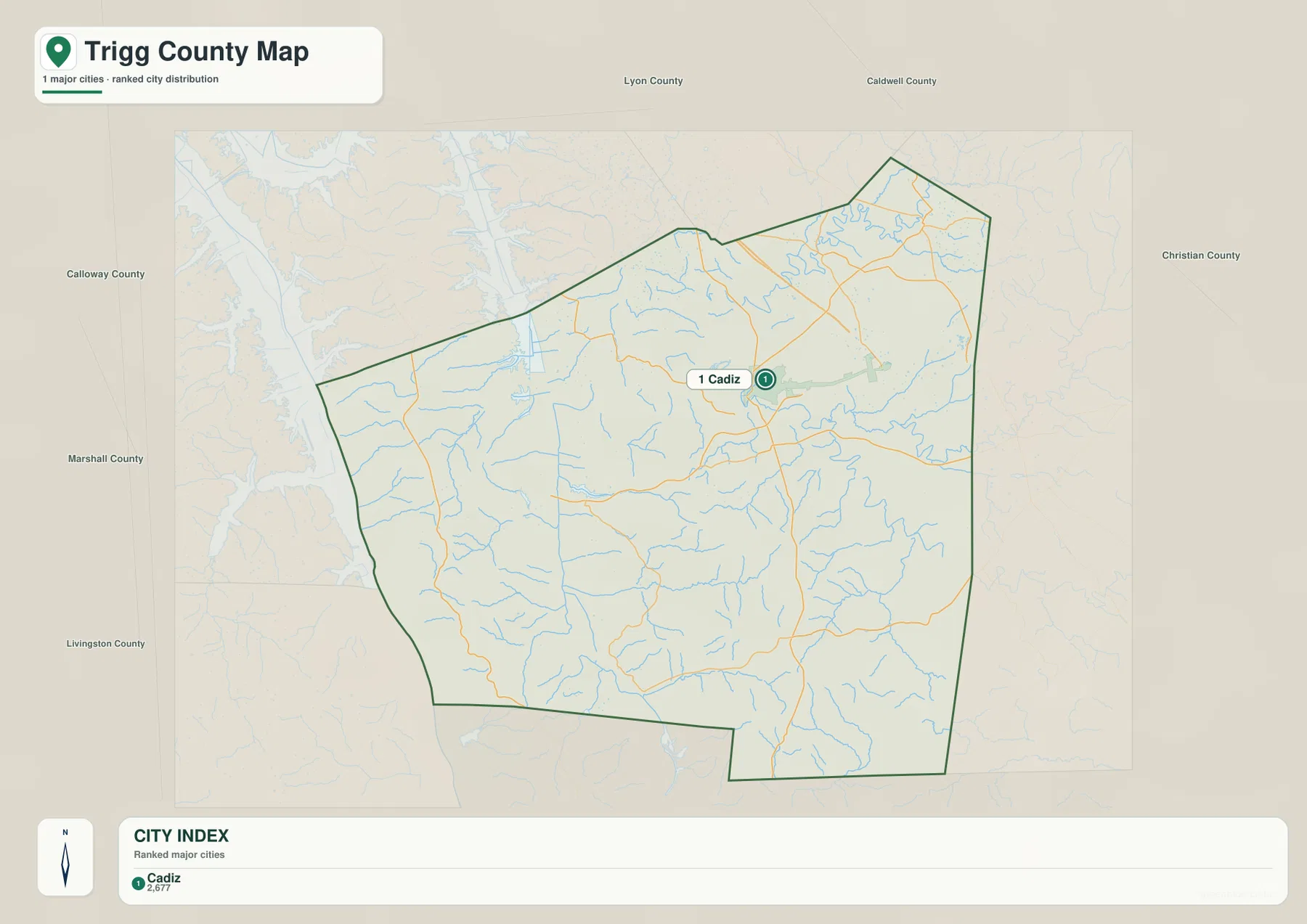
The city-distribution map deliberately removes much of the road detail and gives Cadiz a single prominent marker. That makes it useful when the question is simply where the county’s main settlement lies. Cadiz sits northeast of the county’s visual center rather than in the middle of the outline, with a large stretch of water-influenced land to the west and broad rural territory extending south toward Tennessee.
Neighboring county labels provide a second layer of orientation. Lyon and Caldwell Counties lie to the north, Christian County is to the east, and Calloway, Marshall, and Livingston appear around the western side of the map. The southern boundary does not continue into another Kentucky county because Trigg County reaches the Tennessee state line. Seeing these names around the outline makes the county’s position within western Kentucky easier to explain than a city marker alone would.
The number printed in the city index comes from the source used to build this particular map and should not be treated as a current official population total. Anyone needing recent demographic figures should consult the U.S. Census Bureau or local government data. The purpose of this file is spatial: it shows how Cadiz relates to the county boundary, nearby counties, and the large western water system without the visual clutter of every road and stream.
Lake Barkley, Cumberland River, and Little River define the water geography
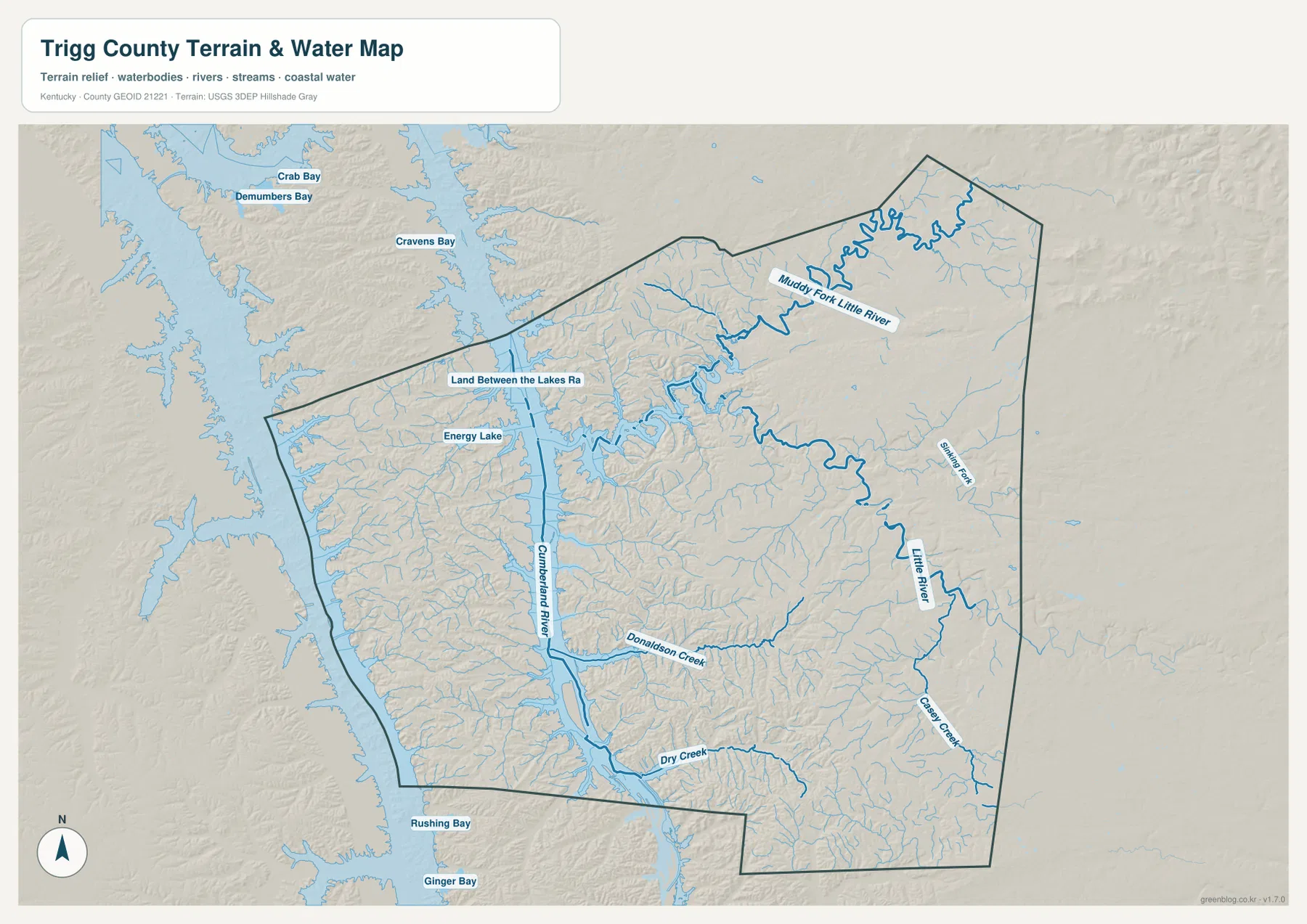
The water map changes the visual balance of the county. The Cumberland River and Lake Barkley corridor dominates the west, where broad blue water and branching coves divide the landscape into ridges and narrow landforms. Energy Lake is labeled inside the western half, and several named bays appear just beyond the county edge. These features explain why the western boundary and road system look so much more irregular than the inland side around Cadiz.
Farther east, the Little River system becomes the main organizing feature. Muddy Fork Little River winds across the northern interior before connecting with the larger drainage. Little River runs through the eastern and central part of the county, while Sinking Fork approaches from the east. Donaldson Creek extends toward the Cumberland corridor, and Dry Creek and Casey Creek mark separate southern valleys. The smaller blue lines around them show that Trigg County is cut by many short tributaries rather than one isolated river channel.
Land Between the Lakes is also part of the geographic story of the western side. The supplied map includes a Land Between the Lakes road label, and local official information regularly points visitors toward Lake Barkley and the national recreation area. Those references help explain why the western edge is not just another rural section of the county: large public water and recreation landscapes occupy a prominent place there.
This map should not be used as a flood map, nautical chart, depth map, parcel boundary, or legal shoreline document. It is designed to show the relative position of rivers, creeks, lakes, and terrain. Flood risk, boating, water quality, or regulatory questions require current information from the agencies responsible for those subjects.
Relief from 107 to 246 meters reveals low water corridors and higher ridges
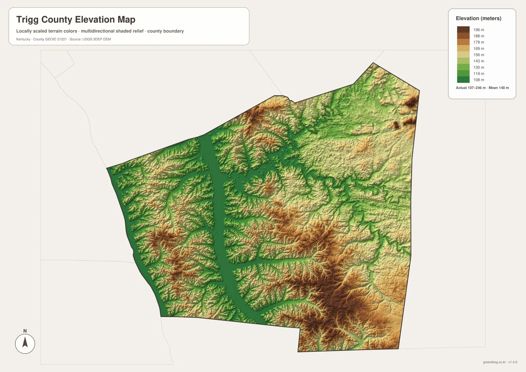
The elevation legend gives an actual county range of about 107 to 246 meters, with a mean near 148 meters. Greens mark the lower ground, while yellow, orange, and brown shades represent progressively higher terrain. The lowest areas closely follow the major water corridors, especially the Cumberland River and Lake Barkley system. That relationship is visible immediately because long green valleys sit between bands of higher ridges.
South-central and southeastern Trigg County contain several of the strongest clusters of higher relief on the map. Brown and orange ridges are separated by narrow green valleys, creating a branching pattern that mirrors the creek network. The effect is not mountainous in the sense of very high elevation, but it is distinctly dissected terrain. Short distances across the map can involve repeated climbs and descents between ridge tops and stream bottoms.
The north and northeast are more mixed. Broad zones of moderate color are interrupted by stream-cut lowlands, while the western lake corridor remains visibly lower. Around Cadiz, the relief is less dramatic than in the highest southern ridge clusters, which fits the denser road connections seen on the general map. Comparing the two files side by side helps explain why some roads around the county are relatively direct while others bend through valleys or around water.
The elevation surface is generalized for county-scale comparison. The 107–246 meter range and 148 meter mean are useful for understanding Trigg County’s overall terrain, but they are not survey-grade values for a building site, bridge, parcel, or engineering project. Detailed design work should use the underlying USGS 3D Elevation Program data at an appropriate resolution and, where necessary, professional field survey measurements.
Comparing the lake country with the inland side of Trigg County
The biggest contrast in Trigg County is between the western lake-and-river landscape and the inland country centered on Cadiz. On the road map, Cadiz and its highway connections naturally attract attention. On the water map, however, the Cumberland River and Lake Barkley become the dominant features, and the west appears far more fragmented by shoreline. The elevation map then adds a third layer, showing that those water corridors occupy low ground between ridges.
One useful comparison starts at Cadiz and follows US 68/80 west. The county map emphasizes the road and nearby communities. The water map shows the increasing number of channels and coves toward the Cumberland corridor, while the elevation map shows long low valleys surrounded by higher ground. Looking at the same direction in three different files turns what might look like a simple road connection into a much clearer picture of how transportation, drainage, and relief interact.
The southern and eastern sides reward a different comparison. Little River, Sinking Fork, Casey Creek, and Dry Creek can first be identified on the water map, then traced as lower green corridors through the elevation surface. Between them, higher ridges form the rolling country that appears only subtly on the general road map. For teaching or regional orientation, this approach is more informative than listing every road or stream separately because the same places remain connected across each map.
Choosing the right Trigg County file for the question
The general county map is the best starting point when roads, place names, and the boundary all matter at once. The city map is cleaner when Cadiz and the neighboring-county context are the main subject. The terrain-and-water map is the strongest choice for Lake Barkley, the Cumberland River, Little River, and tributary valleys, while the elevation file makes the 107–246 meter relief pattern much easier to see.
- County map: Use it for Cadiz, Cerulean, Fenton, US 68/80, KY 139, KY 124, KY 276, KY 272, and the county outline.
- City map: Use it to highlight Cadiz and show its position relative to Lyon, Caldwell, Christian, Calloway, Marshall, and Livingston Counties.
- Terrain and water map: Use it for Lake Barkley, Cumberland River, Little River, Muddy Fork Little River, Donaldson Creek, Dry Creek, Casey Creek, Sinking Fork, and Energy Lake.
- Elevation map: Use it to compare the low water corridors with higher southern and central ridges across the 107–246 meter range.
Each original JPG measures 3638 × 2572 pixels, so the downloaded files preserve more detail than the web previews. Keeping the original aspect ratio is helpful when printing, and very small print sizes can make creek names and road shields difficult to read. When several maps are used in a presentation, a clear sequence is Cadiz and roads first, water geography second, and elevation last so the audience can connect the same places across each view.
Frequently Asked Questions
Which map is best for Cadiz, US 68/80, and KY 139?
The general county map is the best choice because it combines Cadiz, the county boundary, US 68/80, KY 139, and additional numbered routes such as KY 124, KY 276, KY 272, and KY 807. If the goal is simply to show where Cadiz sits inside the county, the city map removes most of that extra detail.
Where can I see Lake Barkley, Little River, and the tributary network most clearly?
The terrain-and-water map is the most useful file for that purpose. It labels the Cumberland River and Lake Barkley corridor along with Little River, Muddy Fork Little River, Donaldson Creek, Dry Creek, Casey Creek, Sinking Fork, and Energy Lake. It is a geographic reference, not a flood-risk, navigation, or water-depth chart.
Can the 107–246 meter elevation map be used for surveying?
No. The elevation file is intended for county-scale comparison of low valleys and higher ridges. Its approximately 107–246 meter range and 148 meter mean help describe regional relief, but construction, drainage design, engineering, and property-level elevation work require more precise source data and appropriate field measurements.
Map File Information
The ZIP contains high-resolution JPG versions of the Trigg County general map, city map, terrain-and-water map, and elevation map. Use the previews to check Cadiz, the main roads, Lake Barkley and Cumberland River waterways, Little River tributaries, and the 107–246 meter relief before selecting the original files.
- Included Files: Use only the versions confirmed in the article and supplied images
- File Type: Use the confirmed download contents
- Intended Use: Printing, education, presentations, and map-based projects
Related Maps
Sources and references
The geographic discussion is based primarily on the supplied Trigg County maps, with official county, city, boundary, hydrography, and elevation sources used for context.
- Trigg County official website — county location, neighboring areas, and Lake Barkley context.
- City of Cadiz official website — local Cadiz information and regional references to Lake Barkley and Land Between the Lakes.
- U.S. Census Bureau TIGER/Line Shapefiles — official geographic boundary and road data.
- USGS National Hydrography — federal hydrography background for rivers, creeks, and water features.
- USGS 3D Elevation Program — federal elevation and terrain data program.
Green Map creates custom-edited map images using open geographic data sources such as geoBoundaries, Natural Earth, OpenStreetMap, and government open data. These maps are edited visual materials, not raw data files, and are provided for education, documents, presentations, and graphic reference.