Montgomery County sits in Kentucky’s Outer Bluegrass region with Mount Sterling serving as the main urban and road reference. Interstate 64 and routes 60, 460, 713, 11, and 213 connect the central city with Camargo, Jeffersonville, and the surrounding rural valleys. The physical maps show Hinkston Creek, Spencer Creek, Grassy Lick Creek, Somerset Creek, Brush Creek, Slate Creek, and a dense pattern of smaller tributaries. The original high-resolution JPG map files can also be downloaded together in one ZIP archive for printing, classroom work, presentations, or offline reference.
The official Montgomery County Fiscal Court website identifies Mount Sterling as the county seat and describes the county as part of Kentucky’s Outer Bluegrass region. The supplied maps show that central role clearly: Mount Sterling has the strongest concentration of roads and public landmarks, while the outer county becomes progressively more rural and dissected by creek valleys. The elevation map reports an actual range of about 217 to 438 meters with a mean near 284 meters.
Table of Contents
Mount Sterling concentrates the county’s main road connections
The general county map makes Mount Sterling the easiest place to begin. Interstate 64 passes near the city, route 60 extends east-west, route 460 runs south toward Camargo, and route 713 approaches from the west. The Saint Joseph Hospital and Morehead State University at Mount Sterling markers provide additional reference points around the urban area.
Camargo lies south of Mount Sterling near route 460, with local roads continuing toward the southeastern interior. Jeffersonville is farther southeast near routes 213, 599, and 965, and the historical Salem label appears nearby. The road pattern becomes noticeably more winding in this part of the county because streams and ridges occupy much of the terrain between settlements.
Route 537 serves the northern part of the county, while routes 646 and 11 help organize the western and southwestern side. Sharpsburg, Owingsville, Clay City, and Stanton appear outside the boundary as useful regional references. Those labels make Montgomery County’s position between the Outer Bluegrass and the more rugged eastern Kentucky landscape easier to understand.
This map is intended for geographic orientation rather than live navigation. It does not show current construction, road closures, bridge restrictions, or travel times. Creek valleys and repeated ridges can make actual driving routes longer than the direct separation between two places.
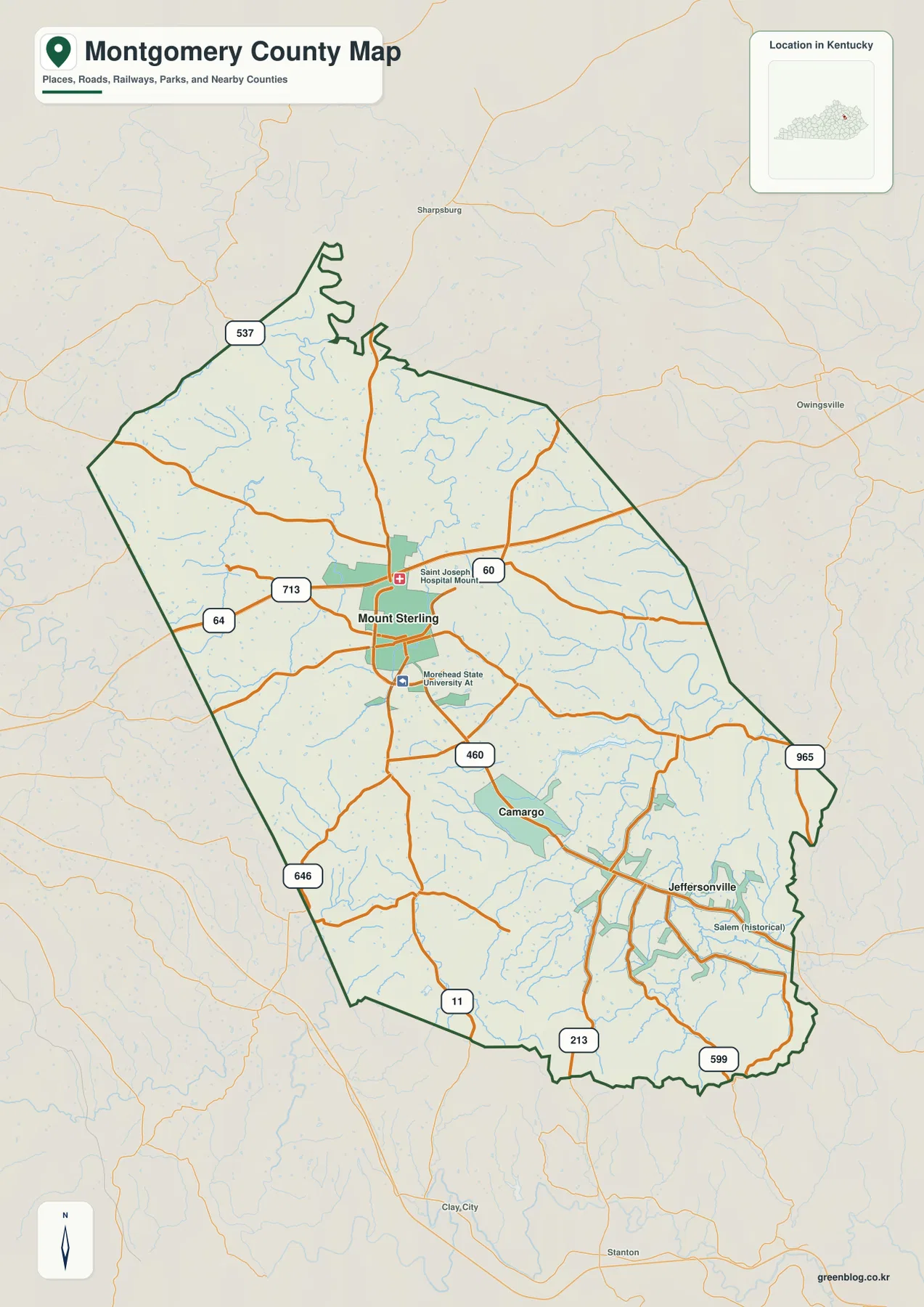
Jeffersonville and Camargo lie 10 and 5 straight-line miles from Mount Sterling
The city-connections map uses Mount Sterling as the hub and highlights Jeffersonville and Camargo. The supplied map labels Mount Sterling with 7,551 residents, Jeffersonville with 1,651, and Camargo with 874. It shows a direct distance of about 10 miles from Mount Sterling to Jeffersonville and about 5 miles from Mount Sterling to Camargo. These are straight-line distances between mapped points rather than driving distances.
Camargo is the closer southern community, while Jeffersonville sits farther southeast. Actual travel between the three places follows route 460 and a network of local roads, including routes 213, 599, and 965 near Jeffersonville. Because the southeastern county contains many creek valleys and higher ridges, road distance and travel time can differ substantially from the direct lines on the simplified map.
Removing most local-road and stream detail makes the relative spacing especially clear. Camargo appears as an intermediate southern reference, while Jeffersonville occupies a separate southeastern area closer to the county edge. Once those locations are familiar, Spencer Creek, Slate Creek, and the southeastern elevation pattern are much easier to place on the physical maps.
The city view works well in a classroom or presentation when direction and relative distance matter more than routing detail. The general county map is the better choice for road numbers, public landmarks, and smaller place references. Mount Sterling remains the common anchor between both views.
Hinkston Creek and Spencer Creek organize the central and eastern drainage
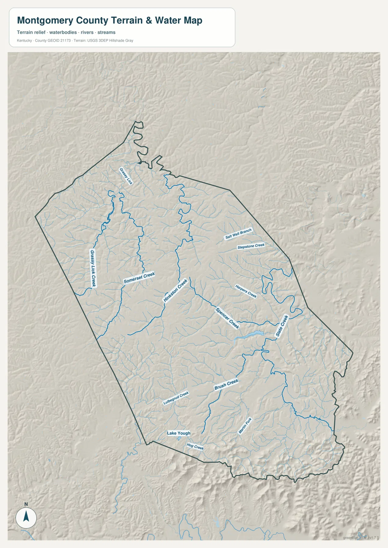
Hinkston Creek is one of the strongest named water features on the terrain-and-water map. Several northern tributaries feed into the central system, while Somerset Creek approaches from the west. Grassy Lick Creek occupies another long valley in the northwest and helps define the drainage pattern on that side of the county.
Spencer Creek extends across the central-eastern interior, and Slate Creek becomes an important reference closer to the eastern boundary. Salt Well Branch, Stepstone Creek, and Hoppers Creek add smaller named valleys in the same broad area. Rather than one wide flat drainage corridor, eastern Montgomery County contains many separate creek valleys divided by low ridges.
In the south, Brush Creek and Lulbegrud Creek occupy distinct valleys, while Martin Fork reaches through the southeastern interior. Lake Yough provides a small water landmark near the southwestern edge, and Hog Creek follows part of the southern boundary area. These waterways correspond closely with the lower green corridors visible on the elevation surface.
A practical way to read the physical map is to begin with Hinkston Creek and Somerset Creek, then move east to Spencer and Slate creeks before tracing Brush Creek and Martin Fork in the south. The map is not intended for current flood stage, fishing regulations, water quality, or private-access decisions. Those questions require current information from the responsible agencies.
Elevation from 217 to 438 meters rises sharply toward the southeast
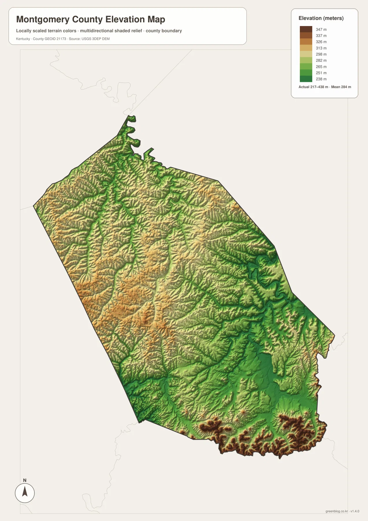
The elevation map reports an actual county range of about 217 to 438 meters and a mean near 284 meters. Lower green terrain follows Hinkston Creek, Spencer Creek, and many smaller tributary valleys, while the Mount Sterling area occupies comparatively gentle central ground. The highest brown and dark-orange terrain is concentrated along the southeastern edge, creating the strongest relief contrast in the county.
The west and northwest contain a tighter alternation of valleys and ridges. Grassy Lick Creek and Somerset Creek form low green corridors, while the ground between them rises into yellow and brown uplands. That pattern adds context to the winding routes 537, 646, and 713 on the road map.
East of the center, Spencer Creek and Slate Creek occupy longer low corridors before the terrain becomes more rugged near Jeffersonville. The southeastern boundary has repeated high ridges separated by narrow stream valleys. Camargo lies between the gentler Mount Sterling area and that more strongly dissected southeastern terrain.
The elevation colors are designed for county-scale comparison rather than parcel-level measurement. They are useful for distinguishing creek valleys from uplands and high ridges, but they should not be treated as survey-grade elevation for a road, structure, property, or engineering project. Exact site work should rely on current source data or professional surveying.
Following Montgomery County from Mount Sterling to the western creeks and southeastern ridges
Mount Sterling is the simplest starting point for comparing the map views. On the road map, locate Interstate 64 and routes 60 and 460, then identify Camargo to the south and Jeffersonville to the southeast. On the physical map, Hinkston Creek and Spencer Creek provide the main drainage references around the central and eastern county.
For the west, use routes 713 and 646 together with Grassy Lick Creek and Somerset Creek. The elevation view shows those waterways as lower corridors between rolling uplands. Moving away from Mount Sterling, the map becomes increasingly rural, with smaller roads and tributaries replacing the dense central street pattern.
For the southeast, begin with Camargo and Jeffersonville and follow routes 460, 213, 599, and 965. Spencer Creek, Slate Creek, and Martin Fork provide the main water references. The elevation map shows some of the county’s strongest ridge relief in the same area, making the southeastern section especially easy to distinguish from the gentler central ground.
Choosing the best Montgomery County map for print, class, or reference
Use the general county map when Mount Sterling, Camargo, Jeffersonville, numbered roads, public landmarks, and the full boundary need to appear together. The city-connections map is cleaner when the main question is how Jeffersonville and Camargo relate to Mount Sterling and what their straight-line distances are.
Choose the terrain-and-water map for Hinkston Creek, Spencer Creek, Grassy Lick Creek, Somerset Creek, Brush Creek, Slate Creek, and Martin Fork. The elevation map is the strongest view for explaining the difference between lower creek corridors and the high southeastern ridges. Comparing water and elevation together makes the county’s terrain much easier to understand.
The WebP images in the article are optimized for browser viewing. The downloadable ZIP contains the original JPG maps at 2,572×3,638 pixels each, which is better suited to printing, classroom worksheets, presentations, and offline reference. These maps are general geographic resources rather than legal boundary records, flood studies, parcel surveys, navigation products, or engineering plans.
Frequently Asked Questions
Are the Mount Sterling-to-Jeffersonville and Mount Sterling-to-Camargo distances driving distances?
No. The city-connections map shows straight-line distances of about 10 miles to Jeffersonville and 5 miles to Camargo. Actual driving distances can be longer because roads follow creek valleys, ridges, intersections, and available crossings rather than the direct line between points.
Which map best shows Hinkston Creek and Spencer Creek together?
The terrain-and-water map is the best choice. It shows Hinkston Creek, Somerset Creek, Grassy Lick Creek, Spencer Creek, Slate Creek, Brush Creek, Martin Fork, and many smaller tributaries in one view.
Can the 217–438 meter elevation range be used as an exact property elevation?
No. The range summarizes the actual countywide elevations shown on the supplied map, with a mean near 284 meters. It is useful for comparing creek valleys with higher ridges, but exact site elevations should come from current source data or professional surveying.
Map File Information
The ZIP archive contains the original high-resolution JPG versions of the Montgomery County road-and-boundary map, city-connections map, terrain-and-water map, and elevation map. Each image is 2,572×3,638 pixels for printing, classroom work, presentations, and offline reference.
- File Type: 4 JPG files inside one ZIP archive
Related Maps
Sources and references
County and Mount Sterling information is available from the official Montgomery County Fiscal Court website and its About Us page. For underlying geographic data, see the U.S. Census Bureau TIGER/Line Shapefiles for boundaries and roads, USGS National Hydrography for streams and water features, and the USGS 3D Elevation Program for elevation data.
These maps are intended for geographic explanation, printing, and general reference. Legal boundary decisions, live traffic, flood and water-safety questions, property surveying, and engineering work should rely on the latest authoritative information from the responsible public agency.
Green Map creates custom-edited map images using open geographic data sources such as geoBoundaries, Natural Earth, OpenStreetMap, and government open data. These maps are edited visual materials, not raw data files, and are provided for education, documents, presentations, and graphic reference.